Showing 1049 items
matching earth
-
 Eltham District Historical Society Inc
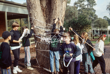
Slide - Photograph, World Environment Day 1993, Heidelberg-Kinglake Road, Hurstbridge, 5 June 1993
World Environment Day was established by in 1972 by the United Nations General Assembly on the first day of the Stockholm Conference on the Human Environment. Two years later, in 1974 the first World Environment Day was held with the theme "Only One Earth" and is observed every year on June 5 to encourage awareness and environmental protection. According to United Nations, "The celebration of this day provides us with an opportunity to broaden the basis for an enlightened opinion and responsible conduct by individuals, enterprises, and communities in preserving and enhancing the environment." 35mm colour positive transparency (1 of 23) Mount - Black and Whiteworld environment day 1993, heritage tree, significant tree, heidelberg-kinglake road, hurstbridge, hurstbridge shopping centre -
 Eltham District Historical Society Inc
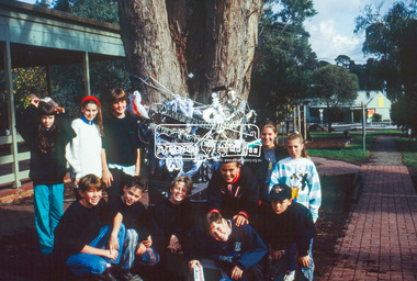
Slide - Photograph, World Environment Day 1993, Heidelberg-Kinglake Road, Hurstbridge, 5 June 1993
World Environment Day was established by in 1972 by the United Nations General Assembly on the first day of the Stockholm Conference on the Human Environment. Two years later, in 1974 the first World Environment Day was held with the theme "Only One Earth" and is observed every year on June 5 to encourage awareness and environmental protection. According to United Nations, "The celebration of this day provides us with an opportunity to broaden the basis for an enlightened opinion and responsible conduct by individuals, enterprises, and communities in preserving and enhancing the environment." 35mm colour positive transparency (1 of 23) Mount - Black and Whiteworld environment day 1993, heritage tree, significant tree, heidelberg-kinglake road, hurstbridge, hurstbridge shopping centre -
 Bendigo Historical Society Inc.
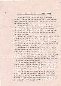
Document - RESEARCH PAPERS: THOMAS WILKINSON PINNIGER, 1828
Thomas Pinniger (1828-1927) was born in England and emigrated to New Zealand before coming to Australia in 1852. With a team of 4 he conducted the first geodetic* survey of Victoria. He became the Government Surveyor for Bendigo in 1853 and in 1854 he laid out the plans for the town of Broadford. His son George, became the Victorian Surveyor General 1925-6. * Large scale mapping based on global measurements of large land masses. It allows corrections for the curvature of the earth.Document detailing the history of district serveyor Thomas Wilkinson Pinniger and his family history. -
 Christ Church Anglican Parish of Warrnambool
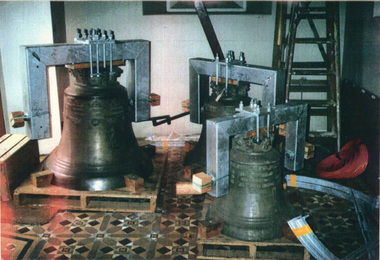
Peal of three German Bells: Memorial to Frederick Stephen STEVENS, Messrs Radler of Hanover, Germany, Late nineteenth century
The bells were sent to the Melbourne Exhibition of 1881. They were awarded first prize. Guaranteed to chime to the sixteenth of a tone. They were purchased by Frederick Perkins Stevens and given to Christ Church Warrnambool as a gift in memory of his son, Frederick Stephen Stevens, who died at his Queensland property in1879.These German bells are the oldest matched peal in Australia.Three bells weighing 9cwt, 5cwt and 3cwt respectively, decorated with angels, medallions and inscriptionsThe largest bell has "Gloria in excelsis Deo: (Glory to God in the highest)"Vivos voco" (I summon the living) and "Motuos plango" (I bewail the dead). The second bell has "In terra pax" (Peace on earth); and the third bell has "In hominibus beneplacitum" (Goodwill towards men) Another inscription in German is "Siehe die Steine Rufen, Ehre sei Gott in de Hohe" (Behold the stones cry, Honour to God in the height)frederick perkins stevens, frederick stephen stevens, melbourne exhibition 1881, radler, warrnambool victoria -
 The Beechworth Burke Museum
Geological specimen - Native Sulphur, unknown
Native Sulphur in its solid form is a yellow crystalline mineral that forms near volcanic vents and fumaroles where it is the solid form of hot gases. It is also frequently found in the subsurface as a by-product of sulphide ore mineralization. In all its forms, sulphur is one of the most commonly occurring minerals on the planet, especially in natural gases, and is key to the make-up of a range of other minerals. It is essential to continuing life on earth, and was used in ancient societies as part of medical care, religious rites, and entertainment, and was key to the invention of gunpowder by the Chinese. Native Sulphur in its solid form is a yellow crystalline mineral that forms near volcanic vents and fumaroles where it is the solid form of hot gases. It is also frequently found in the subsurface as a by-product of sulphide ore mineralization. In all its forms, sulphur is one of the most commonly occurring minerals on the planet, especially in natural gases, and is key to the make-up of a range of other minerals. It is essential to continuing life on earth and was used in ancient societies as part of medical care, religious rites, and entertainment, and was key to the invention of gunpowder by the Chinese. The exact site of extraction for this specimen is unknown, but it was probably collected in New Zealand in the 1850s. Sulphur is significant both for its historical and current uses, and for its nature as one of the most abundant minerals on the planet. Sulphur's importance comes both from its abundance and its role in ensuring survival, creating other minerals, and daily human life. This specimen is significant as representative of sulphur's solid properties. This specimen is part of a larger collection of geological and mineral specimens collected from around Australia (and some parts of the world) and donated to the Burke Museum between 1868-1880. A large percentage of these specimens were collected in Victoria as part of the Geological Survey of Victoria that begun in 1852 (in response to the Gold Rush) to study and map the geology of Victoria. Collecting geological specimens was an important part of mapping and understanding the scientific makeup of the earth. Many of these specimens were sent to research and collecting organisations across Australia, including the Burke Museum, to educate and encourage further study.A solid, small, crystalline mineral specimen that is largely bright yellow, with some darker spotting. geological specimen, geology, geology collection, burke museum, beechworth, sulphur, native sulphur, new zealand, native sulphur specimen, sulphur specimen -
 Shepparton RSL Sub Branch
Sniper shield, c. 1910s
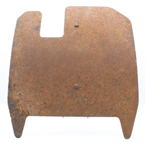
This sniper shield may have been used by German troops during the First World War. There are few other examples of sniper shields of this shape or style, so it was possibly not a widely used design.Metal sniper shield constructed of a large flat front with curved edges, onto which a handle-like piece is soldered on one end and bolted on another. This handle has a pin which presumably adjusts the height/angle of the shield in relation to the ground. The third piece of the shield is a stand with a curved end, presumably rests on the ground, and on the other end a series of five holes which adjust the height/angle. The shield itself is roughly square in shape with a rectangular cut out off-centre at the top and a larger rectangular cut out at the base, which forms two pointed ends, possibly for securing into earth like a peg."G-01" is inscribed in ink, a registration number rather than historic inscription.germany, first world war, world war i, world war 1, the great war, sniper, firearm -
 Bendigo Historical Society Inc.
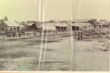
Photograph - LONG GULLY HISTORY GROUP COLLECTION: STREETSCAPE
Black and white photo of a streetscape with various buildings, earth street and wood rail fencing. At the right edge is the Commercial Hotel. In the centre is a building with a veranda with P. Pentreath printed above the veranda. At the edge of the veranda is a sign with Post Office on it. Next is a Dr J W Sibley, Physician next to a bakery. On the left of the photo is a slab building with the windows propped open and a cart in the front of it. A two rail fence is in the front of the hut. There are other buildings in the background including what looks like a church behind the slab hut. The photocopy for this item is not available at this time, 23 Jan. 2020. The original photo for this item is at the bottom of box 621bendigo, history, long gully history group, the long gully history group - streetscape, p pentreath, commercial hotel, dr j w sibley? -
 Old Castlemaine Schoolboys Association Inc.
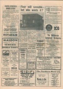
Newspaper Clipping, Castlemaine Mail 11/10/1978
4 pages of newspaper. Articles include: Earth Stresses under studt Castlemaine Flour Mill Saveable - But who wants to save it? Melbourne Symphony Orchestra and Thompsons foundry band playing together Birth of Kirstyn Leanne Butterworth Birth of Tanya Louise Serpell Birth of Shane Daniel Brown Death of Robert Oscar Dodd Death of Betty Farrell Death of Lena Heritage Death of Peter James Megee SSW Advertising Allan Craig Baker Accident Peter Baker Accident Footpath Construction in forest, Duke and McGrath Streets Old Boys Reunion This Weekend Notice of AGM - Old Castlemaine Schoolboys Association castlemaine flour mill, melbourne symphony orchestra, thompsons foundry band -
 Federation University Art Collection
Artwork, Yasmin Williams, 'Spiritual Head' by Yasmin Williams, 2016
Yasmin WILLIAMS (1991 - ) B. Ballarat, Victoria This works was completed while Yasmin Williams was a student at Federation University Arts Academy in the Bachelor of Fine Arts (Visual Arts).Artist's Statement: Through-out life we have our own different realities of the world we exist in. From childhood to adulthood our perception of the world is reshaped constantly in every way. These pieces of ‘found object’ and earthen artworks are surreal and re-purposed reflections of the reality I have a grasp of, and each found item creates its own narrative, balance and connection with its surroundings. When viewing these works I hope that the viewer is grounded by the earth and stone and helps to create a personal link or relationship with the abandoned objects that once belonged to another person, therefore creating their own narratives and perception of the world.yasmin williams, artwork, available -
 Kiewa Valley Historical Society
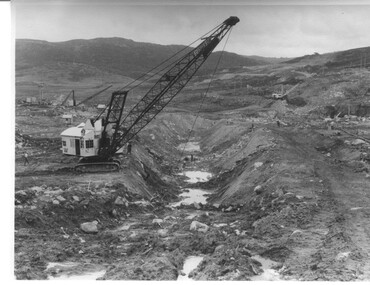
Photograph Rocky Valley Dam Excavations, Rocky Valley Dam Wall Excavation, c1947-48
Work commenced at Rocky Valley Dam site in early 1947 and proceeded until May. Resumed work in October after the winter and a camp for the accommodation of workmen was commenced at this time. Work continued in 1948 with the establishment of work facilities, including the erection of two large excavators. At the dam site the river was diverted through a temporary pipeline. Work proceeded in the summer months with the placing of concrete in the foundations and earth and rock fill for the construction of the wall. Rocky Valley and associated spillway and outlet works were completed in March, 1959. A very good representation of the type of machinery available in the 1940's used for excavation of the dam and the construction of the dam wall.Black and white photograph of Rocky Valley Dam wall under construction. There are at least three cranes plus workmen in the photo. This is taken from the Heathey's Spur side of the dam wall looking back toward Sun Valley.Hand written on back of photograph "Rocky Valley Dam Wall Excavation" in blue ink.rocky valley, dam, wall, machinery -
 Wangaratta RSL Sub Branch
Citation, Military Medal
During the attack on Polygon Wood Belgium on 20th September 1917 Pte Sandow displayed conspicuous gallantry - He was an operator on Amplification and Power Buzzer Station in a chain of communication and in the enemy barrage he patrolled and repaired lines and earths utterly regardless of personal danger. While in the performance of his duty his leg was shot away. He however completed his task. It was largely due to this man's effort that good communication was maintained. Private Sandow died of wounds on 22 September 1917 and was buried at Lijssenthoek Military Cemetery. Cream coloured citation with Australian Coat of Arms above black type contained in black border.Military Medal 1120 Private Roy Llewellyn Sandow 5th Australian Infantry Battalion attached 1st Australian Divisional Signal Company 1st Australian Divisionroy llewellyn sandow, polygon wood, belgium, 1917, ww1, 5th australian infantry battalion -
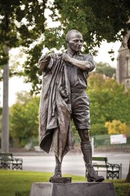 City of Ballarat
Artwork, other - Public Artwork, Albert Coates Memorial by Louis Laumen, 2012
Leading surgeon and academic Sir Albert Coates (1895-1977) is one of Ballarat's most celebrated sons. A medical orderly during WWI, he returned home to become a pioneering neurosurgeon. A medical man in the worst of circumstances, Coates is often mentioned for his compassion and care in his role as a doctor in the Burma-Siam Railway POW camps. The bronze statue by Louis Laumen captures his down-to-earth nature. Laumen is a Melbourne sculptor who has completed many commissioned bronze public artworks around Australia.The statue is of aesthetic and historic significance to the people of BallaratBronze figure mounted on granite, amid garden plantings and plaques.Inscription details the life of Albert Coates.albert coates, medicine, pow camps -
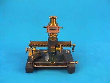 The Ed Muirhead Physics Museum
Meldometer, Joly
The Joly meldometer was created to determine the melting point of minerals. W.E. Wilson, an astronomer and author, stated in 1900 that the Joly meldometer consisted of a ‘a strip of platinum on which minute fragments of any mineral can be placed, while any alteration in its length can be determined by means of a micrometer screw which touches a lever connected with one end of the strip. The strip can be heated by an electric current, and is calibrated by observing the micrometer readings corresponding to the temperatures at which some substances of known melting-points melt’i . One reason why the Joly meldometer was seen as a successful addition to science was the small amount of any substance that it required for testing. Only a minute sample was needed for the instrument to work and so a tiny part could be taken from a delicate item without destroying itii . The instrument was originally manufactured by the Irish company Yeates & Son of Dublin. The Yeates family business was established in the early 1790’s and is thought to have operated until approximately 1922iii . Their business slogan was recorded as ‘Instrument makers to the University’, a slogan which proudly exhibited their relationship with Trinity College, Dublin. The company was located directly opposite Trinity College, the place where the Joly meldometer was created. Working in such close proximity must have assisted this business relationship. The inventor of this meldometer was Irishman John Joly. Joly was born in 1857 at the Church of Ireland Rectory, Hollywood House. His education led him to Trinity College Dublin where, by 1891, he had obtained a Bachelor of Engineering degree as well as a Doctorate of Science. The entirety of his working life appears to have taken place at Trinity College although he is known to have travelled in order to consult with other scientists such as the world renowned Sir Ernest Rutherford. The Joly meldometer was used for a variety of different purposes, with scientists often adapting the instrument to suit their own needs. For instance, the previously mentioned astronomer W.E. Wilson adapted the meldometer to assist him in measuring the radiation of the suniv . Joly used his device in an attempt to ascertain the age of the earth. In 1913, along with Sir Rutherford, Joly came to the conclusion that the earth was approximately 400 million years old. They did this by analysing the decay of radioactivity in minerals. According to our present knowledge of the earth this was a much more accurate date than the dates Joly had previously derived. He had first thought that the earth was 97 million years old due to the volume of sodium in the oceans. Joly’s second analysis of the topic had resulted in the age of 80 million years. This figure was based on the accumulation of sediment. Apart from designing his meldometer, Joly is also remembered for his work with colour photography. In 1894 Joly discovered a method for creating colour photographs from a single platev . He also studied the use of radiation as a treatment for cancer and persuaded the Royal Dublin Society to establish the Radium Institute to assist hospitals. In 1933 Joly passed away at the age of seventy-six. -
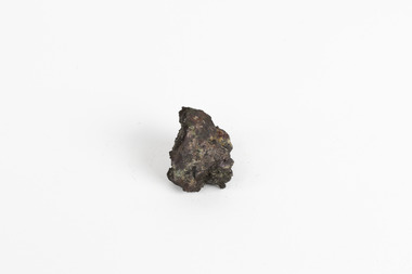 The Beechworth Burke Museum
Geological specimen - Native (metallic) copper, Unknown
This specimen is a native copper specimen that is metallic. Copper is typically found in the earth's crust and is often found alongside other metals such as gold, zinc, lead and silver which all belong to the same group which is the Copper/Gold group. Copper is most commonly formed from large masses of molten lava rock which has solidified in the earth's crust and over time though different sizes and speeds of crystal growth has turned into large amounts of copper, stored in porphyry copper deposits. Copper has a distinctive colour, yet can sometime appear blue and greenish which is often caused by oxidisation or a mixture of copper and other metals. This specific specimen was recovered from Moonta, South Australia. The Moonta Mining Company was established in 1861, after a Shepard in the area noticed traces of copper. This lead to a rush in the copper mining industry which was relatively young in Australia at the time, making Moonta Mining Company one of the richest in Australia. By the 1860's, South Australia had been nicknamed the "Copper Kingdom" due to its vast amount of Large copper mines and resources. As of 2016, Australia was the second largest producer of Copper internationally, following behind Chile in first place. This copper specimen is significant historically and scientifically as it is such an important metal commonly used throughout the world in various ways. Copper is an invaluable recourse used in daily life, used in most electrical appliances as it is a great conductor of heat and electricity, as well as being soft and malleable, making it easy to bend and mould into delicate sheets and wires. Copper does not corrode and is therefore used in the production of water pipes among countless other significant necessities that are often overlooked in our society. Historically, Copper holds great significance as it was the first metal used by humans. It was discovered roughly 9000 years ago and was utilised by the Neolithic Man who learnt that heating the metal made it more malleable, thus tools and utensils were made which were far superior to the previous stone tools used by humans. This history and its connection to the current and ongoing relationship between humans and copper must be preserved and highlighted as it is integral to the history of all humankind. A small, palm-sized solid native copper mineral specimen with shades of browns, black and rustic tones throughout the specimen.NATIVE (metalic) COPPER / Locality: Moonta, South Australiabeechworth, burke museum, geological specimen, native specimen, geological, mineral, mineralogy, indigo shire, beechworth museum, copper, copper ore -
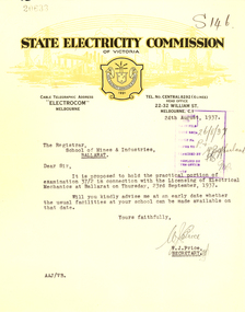 Federation University Historical Collection
Correspondence, State Electricity Commission of Victoria to Ballarat School of Mines, 1937, 1937
The Ballarat School of Mines trained electricians.Correspondence on State Electricity Commission of Victoria letterhead between the State Electricity Commission of Victoria to Ballarat School of Mines in 1937. .1) Dated 16/01/1937 this item relates to the licensing of Electrical Mechanics Regulations 1935 and is signed by W.J. Price .2) Dated 24/08/1937 this item relates to the practical portion of examination 37/2 in connection with Licensing of Electrical Mechanics at Ballarat on 23 September 1937 and is signed by W.J. Price .3) Dates 18 October 1937 this three page foolscap letter relates to radio interference suppressors, and the increasing us of earth leakage circuit breakers for the protection of installations, and is signed by D. Dunhamstate electricity commission of victoria, ballarat school of mines, electricity, trades, electricians, w.j. price, d. dunham, sec -
 Eltham District Historical Society Inc
Slide - Photograph, Clay Nuneham, Stanhope Street, Eltham, 23 May 1993
Built by journalist turned earth builder, John Harcourt as his own home. The 1993 Eltham Heritage Tour was enjoyed by a busload of members of the Historical Society on a fine, calm day, Sunday May 23rd. Between 10.00 am and 4.30 pm, except for a brief lunch stop at the Eltham Living and Learning Centre, members passed about thirty places of local interest and others recommended for the Historic Buildings Register and the Register of the National Estate. A number of significant trees and buildings were also highlighted along with the opportunity to explored some of the properties.35mm colour positive transparency (1 of 24) Mount - Kodak Kodachromeactivities, shire of eltham historical society, heritage excursion, eltham, houses, mudbrick, clay nuneham, mount - kodak kodachrome, scan - 35mm positive, stanhope street -
 The Beechworth Burke Museum
Photograph - Photograph - Reproduction
This photograph depicts the Great Southern Mine located in Rutherglen as it was during the 1900. After the initial Gold Rush of 1853-1854, Gold was discovered deeper under the surface of the earth in the 1860 after the discovery of another deep lead system. Due to the discovery of Gold in Rutherglen, Rutherglen developed into a community in its own right, possessing a population of 6600 by December 1860 and developed into a municipality in 1862. The Great Southern Mine depicted in this photograph required the use of a range of modern technologies, including the hydraulic pumps, in order to reach gold. This photo depicts the mining operations as they were undertaken around the turn of the century.The search for gold is ingrained into the history of Victoria and therefore, images like this one which portray a modern mining operation undertaken in the 1860s, can reveal important information for society and technology for the date when the photograph was taken. This image is of important historical significance for its ability to convey information about the methods used to extract gold in 1900. It is significant as most mining operations around the region, particularly earlier on in the period, used different technologies such as water races. This image is important for current research into the history of Rutherglen more generally, a town which developed singlehandedly due to the discovery of minerals and mining, as depicted here in this photograph, thus indicating an element of social significance as well as historic. The Beechworth Burke Museum has additional images relating to mining and Rutherglen which can be analysed and studied alongside images like this one.A black and white rectangular photograph printed on matte photographic paper.Reverse: $ 3.00 19972503 / a02503 / Great Southern Mine Rutherglen 1900rutherglen mine, rutherglen, great southern mine, beechworth, mine, mining, post goldrush, victoria, gold, 1860s, sluicing, hydrolic sluicing -
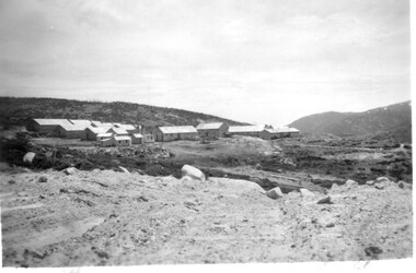 Kiewa Valley Historical Society
11 Black and White photographs of the Rocky Valley area, c1948
In October 1947 construction was commenced on the erection of the workmen's camp at Rocky Valley. Also in 1947 construction of a stream diversion was commenced to allow excavation to commence for the dam wall. In the summer of 1948/49, stripping of the foundation area on both sides of the river was carried out. Weather conditions were not always favourable during the construction, particularly 1955/56 summer, and work would have to cease each year for the winter season due to the severe conditions. The dam is a earth and rock fill structure with a height of about 30.5 metres and crest length 518.16 metres and was completed in March, 1959.These photographs show the type of terrain in the area prior to the construction and filling of Rocky Valley Dam. Also of interest is the type of accommodation provided for those working on the construction and the early cranes available in the 1940/50's. Of historical importance to understand the conditions in the early construction of the Kiewa Hydro Electric SchemeEleven small black and white photographsPhoto No. 1 - on the back, printed in ink"Rocky Valley - New Mess & offices Dec. 1948". In pencil '14 on the back Photo No. 2 - on the back, printed in ink "Rocky Valley Camp. October 1948". Also stamped on the back "998L" Photo No. 3 -on the back, printed in ink "Rocky Valley Hostel October 1948". Also stamped on the back '998L' Photo No. 4 - on the back, printed in ink "Spion Kopje from bedroom window. October 1948". Stamped on the back '998L'. Photo No. 5 - on the back, printed in ink "Rocky Valley Basin Dec. 1948." In pencil on back, 14. Photo No. 6 - on the back, printed in ink "Site of Wall for Rocky Valley Dam Dec. 1948". In pencil on back, 14. Photo No. 7 - On the back, printed in ink "Commencing of Diversion Tunnel Rocky Valley December 1948". In pencil on back, 14. Photo No. 8 - on the back, printed in ink "One of the two electric cranes at Rocky Valley December 1948". In pencil on back, 14. Photo No. 9 - on the back, printed in ink "'Rapier' (H.Y.) electric crane Rocky Valley December 1948". In pencil on back, 14 . Photo No. 10 - on the back, printed in ink " Pretty Valley Pump line construction Mt. Cope in Background Nov 1948. Circular stamp with the words 'print by Wilson White Albury' in the circle. Photo No. 11 - on the back, printed in ink "Stringing cable on Ruined Castle October 1948. Same stamp as No. 10. In pencil '31'. rocky valley; pretty valley; ruined castle; bogong high plains; kiewa hydro electric scheme -
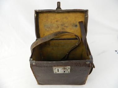 Kiewa Valley Historical Society
Case leather
This case was used between 1950 and 1980's. As part of the Occupation, Health and Safety requirements, equipment used to monitor the performance of electricity producing generators, regularly, hand held testers were used to check the insulation and the "earth" pin were up the the required operational levels. As the generators and their ancillary monitoring equipment was spread over a large area and cumbersome to service small hand held devices were required. These had to always be safe for the user to operate. A selected range of high quality meters were recalibrated every two years in the Meter and Calibration Laboratory at Yarraville(near Melbourne)This leather case contains a meter which is very significant to The Kiewa Hydro Electricity Scheme because it was an integral part of maintaining the electricity producing water driven generators of the power stations. The reason why this meter was so essential is that provided the safety check on equipment used to monitor each Hydro Generator that they were complying within the grid network parameters. Grid parameters are set so that if there is an electrical fault on the system, that fault can be attended to with a very small change in the output stability of each generator. It is essential that the voltage of the network remain within the set limits. Generators are at Dartmouth, Mackay, Clover, West Kiewa, Yarrawonga, Cain Curran and three Power Stations in the Thornton area.This carry case is made from leather hide and cloth covered cardboard insert. The front side has a lockable English made suitcase fitting. It has a broken carry strap (leather) travelling from top and through leather strap holders both sides and on the bottom of the case. A State Electricity Commission of Victoria identification tag riveted onto the top lid "ELECTRICAL ENGINEERING SECTION No. 1483"sec vic kiewa hydro scheme, alternate energy supplies, alpine located electricity generators, mobile measuring equipment -
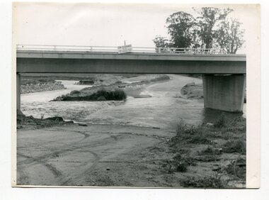 Orbost & District Historical Society
black and white photographs, October 22 1976
The road to Marlo was cut by flood waters from the Snowy River in two places. The road was closed when water flowed over Gilbert's Gulch (3243.1) The Snowy River broke its banks and flooded surrounding Orbost, Marlo, Lochend and Jarrahmond were isolated. The river bank at the bridge site was broken and filled with earth and rock fill. (3243.2) The new Snowy River Bridge was nearing completion when the river rose 7.2 metres causing erosion on the eastern bank. (3243.7) Contractors involved in the construction of the Princes Freeway and bridge were delayed by the flood waters. (3243.8) The 1976 flood at Orbost was a significant event which delayed the construction of the current Snowy River Road Bridge.These photographs record that event.Nine black / white photographs of flood waters across roads. orbost-flood-1976 snowy-river-bridge marlo-road-flood-1976 gilbert;s-gulch-flood -
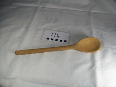 Blacksmith's Cottage and Forge
Wooden Spoon
Used for stirring a multitude of kitchen produced food, especially jam, scones, cakes, and soup. Also used by the mother as a threat to naughty children. The word spoon derives from an ancient word meaning a chip of wood or horn carved from a larger piece.[1] Wooden spoons were easy to carve and thus inexpensive, making them common throughout history. Wooden spoons have been made in virtually every nation on earth and (compared to silver or pewter or gold spoons) represent the ordinary artisan and reflect the life of ordinary folk: this is their "folk art". Source: www.wikipedia.org An essential item found in the kitchen. One piece wooden spoon. Turned marble-shaped decoration at end of handle.kitchen, food, spoon, wooden, stirring, mixing, jam, cakes, batter -
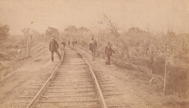 The Beechworth Burke Museum
Photograph - Carte de Visite, William E Barnes
This Carte-de-visite (CdV) taken by renowned Wangaratta based photographer William Edward Barnes previously belonged to the donor's grandfather, Daniel Mullins who was a Police Officer stationed at Glenrowan soon after the Kelly gang siege. Today, the siege has become an important part of Australian culture and Ned Kelly and the Kelly Gang (comprising of Ned Kelly, Dan Kelly, Steve Hart and Joe Byrne) has become ingrained in Australian history and mythology. A CdV is a sepia toned photograph mounted on card and is generally of a small size. This particular style was first patented by Andre Adolphe Eugene Disdéri (1819-1889) in 1854. In 1857, the CdV was introduced to England and after photographs of Queen Victoria, Prince Albert and their family were taken using CdV in 1860 the popularity of this method reached a peak. In this photograph, eight men stand along the railway line near Glenrowan. The photo dates to shortly after 1880 and references the attempt by the Kelly gang to derail a police train in June 1880 on those very tracks. Ultimately, this plan failed and the police train was never derailed. Ned Kelly and the Kelly gang took their final stand at Glenrowan which has been immortalised through Australian popular culture.This photograph is part of the Burke Museum "Kelly album" which includes a significant collection of photographs and artefacts connected to Ned Kelly and the Kelly Gang. Ned Kelly and his gang have become ingrained in Australian popular culture and thus many museums, art galleries and private collections house material connected to the Kelly story which allows the events and people to be researched and interpreted. Artefacts and photographs pertaining to the Kelly gang are particularly valuable for Australian museums. This particular photograph is significant for its connection to Wangaratta based photographer William Edward Barnes and to the Glenrowan Siege of June 1880. Taken at an unknown time, after the siege at Glenrowan, this image depicts eight gentlemen standing about the railway line near Glenrowan. This is a reference to the Kelly gang's plan to derail a train which would barrel up to Glenrowan after news reached Melbourne that Aaron Sherritt had been shot by Joe Byrne in the Woolshed Valley. This image is important for its artistic information that it can provide about the Kelly story and the fashion and streetscape of Glenrowan.This sepia coloured Carte de Visite is attached to yellow cardboard. The obverse of the photo depicts the railway line near Glenrowan around 1880s. The rails are positioned in the centre of the image and are made on an incline of earth. In the foreground are three men, two standing next to the rails and one slightly off to the right of the image. In the background are trees which line the side of the rails and slightly in front of these trees is a group of five men standing on the rails. The reverse of the image is yellow card and contains printed and pencil writing. The printed writing is in the centre of the card. It reveals that the photographer was William E Barnes from Wangaratta. The pencil writing provides the inscription stating that the photo was taken near Glenrowan around the time of Ned Kelly.Pencil: Railway line near / Glen Rowan / Kelly's time / Printed: W. E. Barnes / Photographer / Wangaratta / BMM 8089 /kelly album, glenrowan, glenrowan siege, carte-de-visite, glenrowan railway, ned kelly, kelly gang, last stand, colonial australia, kelly siege, train, railway line, railway, sepia, photography, william e barnes, william barnes -
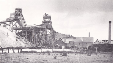
Bendigo Historical Society Inc.
Document - MERLE HALL COLLECTION: ROSALIND PARK CREATIVE VILLAGE BENDIGO PLAN OF MOSAIC AND TYPICAL REEF CONTOURS, 1990s
MERLE HALL COLLECTION: ROSALIND PARK CREATIVE VILLAGE BENDIGO Plan of Mosaic and Typical Reef Contours 3858.14.pdf contains five pages First Page: Describes the plan the mosaic is a stylised representation of the cenral area of the main Bendigo Goldfield. A typical croos section ogf the Bendigo Goldfield. The mosaic are based on actual mine layouts. The artist has used gold as her inspiration. Second Page: A plan of the mosaic using the atomic structure of gold. Third Page: A plan of the quartz vains winding through the earth, containing gold in its various forms. Fourth Page: A typical reef layout in the Bendigo Goldfields and cross sections. Fifth page: On of the Mosiaic depicking a bird -
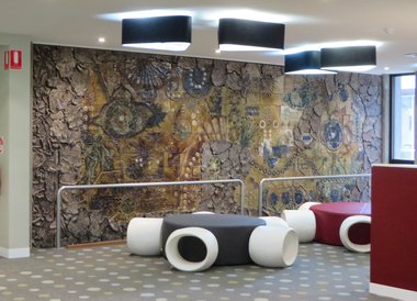 Federation University Art Collection
Artwork, other - Ceramic mural, John Gilbert, 'Enigmatic Land' by John Gilbert, 1973, 1973
ENIMATIC LAND OF BIRDS THAT SING FLOWERS FROMS SEEDS THAT SPRING OF REPTILES AND FISHES CREATURES FROM THE BEGINNING SUN AND MAN AND SCIENCE THE SYMBOLS THAT SILENTLY BUILD AND CHANGE IN COOL AND WARM YOU ARE THERE AND HERE OF YESTERDAY NOW THE SPLITTING EARTH MURAL BY JOHN GILBERT 1973John GILBERT (1935- ) Born Albury, New South Wales John Gilbert worked as a teacher while completing a Certificate of Art at the Technical College in Marlborough, before moving to Ballarat in 1958. He studied at the Ballarat Technical Art School, a division of the Ballarat School of Mines (1960-1961) receiving a Diploma of Art; and Croydon College of Art, London. Gilbert was a Senior Lecturer at the Ballarat Institute of Advanced Education (now Federation University) Art Department until his retirement in the late 1970s. In John Gilbert's Mount Helen studio he produced work marked with an incised 'Gilbert'. He had acquired a concern for form and an interest in sculpture from his teacher Neville Bunning, and from the British potter Hans Coper, whom he visited in 1968. He established two potteries in Ballarat , the Edinburgh Pottery (1972-2005) located within the Sovereign Hill precinct, and the Old Ballarat Pottery (1973-1994) located in the Old Ballarat Village opposite Sovereign Hill. This item is part of the Federation University Art Collection. The Art Collection features over 2000 works and was listed as a 'Ballarat Treasure' in 2007.A large ceramic mural by John Gilbert commissioned for the wall of the E.J. Barker Library. The mural features brown and green glaze with features of indigo. The work has no particular pictorial representation. It is an arrangement of colour and form, designed for enjoyment rather than to analyse. The theme relates to the development of the Universe through basic symbols such as plant forms, fish, birds and to mans development through symbols of science and engineering. The outer edge is symbolic of earths crust being peeled away to reveal science and nature. The mural depicts the changing of seasons from Winter to Summer (left to right). The mural was completed at John Gilbert's Slate Gallery studio, Mount Helen, and took eight months to make.gilbert, artwork, john gilbert, art, ballarat school of mines, mural, ballarat institute of advanced education, ballarat pottery, ceramics, old ballarat pottery, edinburgh pottery -
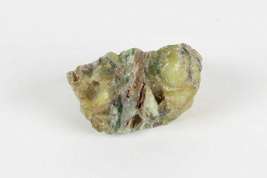 The Beechworth Burke Museum
Geological specimen - Common Opal, Unknown
It is not known where this opal originated. Common Opal is formed from silica-rich water entering the earths crust and hardening into a gel of water and silica-spheres, layered through the specimen. Common opal differs from precious opal in colouration and appearance, with precious opal including more colours, and having a translucent or glossy appearance, where common opal shows less colour and is typically opaque. It scores high on the Mohs hardness scale, and is common throughout the world, especially in Australia, where it is far more prevalent than the highly-prized precious opal. Australia is also the highest producer of opals in the modern world. This specimen is part of a larger collection of geological and mineral specimens collected from around Australia (and some parts of the world) and donated to the Burke Museum between 1868-1880. A large percentage of these specimens were collected in Victoria as part of the Geological Survey of Victoria that begun in 1852 (in response to the Gold Rush) to study and map the geology of Victoria. Collecting geological specimens was an important part of mapping and understanding the scientific makeup of the earth. Many of these specimens were sent to research and collecting organisations across Australia, including the Burke Museum, to educate and encourage further study.A solid, silica-based mineral specimen of Common Opal in shades of grey, green, and yellow, with a thick grey vein running through the centre. geological specimen, geology, geology collection, burke museum, beechworth, opal, common opal, gemstone, mining -
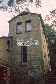
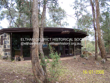
 Eltham District Historical Society Inc
Photograph - Digital Photograph, Marguerite Marshall, Former home of Alistair and Margot Knox, King Street, Eltham, 16 January 2006
Situated in King Street, Eltham, Alistair Knox built his home and office in 1962-1963 with mud-bricks made from the local soil and recycled materials blending the house with bush around it. Knox popularised the Eltham earth building movement, begun by Montsalvat founder, Justus Jorgensen. Alistair Knox (1912-1986) was also an Eltham Shire Councillor 1971-1975 and Shire President in 1975. Knox established the inaugural Eltham Community Festival in 1975. Covered under Heritage Overlay, Nillumbik Planning Scheme. Published: Nillumbik Now and Then / Marguerite Marshall 2008; photographs Alan King with Marguerite Marshall.; p145This collection of almost 130 photos about places and people within the Shire of Nillumbik, an urban and rural municipality in Melbourne's north, contributes to an understanding of the history of the Shire. Published in 2008 immediately prior to the Black Saturday bushfires of February 7, 2009, it documents sites that were impacted, and in some cases destroyed by the fires. It includes photographs taken especially for the publication, creating a unique time capsule representing the Shire in the early 21st century. It remains the most recent comprehenesive publication devoted to the Shire's history connecting local residents to the past. nillumbik now and then (marshall-king) collection, alistair and margot knox house, alistair knox design, mudbrick construction, eltham, king street -
 Eltham District Historical Society Inc
Photograph - Digital Photograph, Marguerite Marshall, Former office of Alistair Knox, King Street, Eltham, 16 January 2006
Situated in King Street, Eltham, Alistair Knox built his home and office in 1962-1963 with mud-bricks made from the local soil and recycled materials blending the house with bush around it. Knox popularised the Eltham earth building movement, begun by Montsalvat founder, Justus Jorgensen. Alistair Knox (1912-1986) was also an Eltham Shire Councillor 1971-1975 and Shire President in 1975. He established the inaugural Eltham Community Festival in 1975. Covered under Heritage Overlay, Nillumbik Planning Scheme. Published: Nillumbik Now and Then / Marguerite Marshall 2008; photographs Alan King with Marguerite Marshall.; p145This collection of almost 130 photos about places and people within the Shire of Nillumbik, an urban and rural municipality in Melbourne's north, contributes to an understanding of the history of the Shire. Published in 2008 immediately prior to the Black Saturday bushfires of February 7, 2009, it documents sites that were impacted, and in some cases destroyed by the fires. It includes photographs taken especially for the publication, creating a unique time capsule representing the Shire in the early 21st century. It remains the most recent comprehenesive publication devoted to the Shire's history connecting local residents to the past. nillumbik now and then (marshall-king) collection, alistair and margot knox house, alistair knox design, mudbrick construction, eltham, king street -
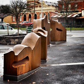 City of Ballarat
Artwork, other - Public Artwork, Cliff Burtt, Buninyong Bivium, 2016
Buninyong Bivium (2016) by Cliff Burtt engages with the geography and history of the Buninyong region in both pre and post settlement. The town of Buninyong is dominated by the profiles of Mt Helen and the extinct volcano Mt. Buninyong. Traditional land of the Wadawurrung people, today the area remains a significant site for the culture of indigenous people and their connection to the land. The profile of this sculpture is based on topographical mapping of the area, depicting sections of the landscape. The gaps between the elements of the work can be viewed as representations of the shafts sunk into the earth by the early gold miners and compound curves on the upper surfaces are mirroring the topography of the area, while cut-aways in the sides are suggestive of rock strata.The artwork is of aesthetic and social significance to the people of BallaratCorten steel sculpture made of five unique sculptural pieces secured to at concreate base at pavement levelbuninyong, cliff burtt, sculpture, public art, mining, ballarat -
Unions Ballarat
Survival now : the human transformation, Cairns, Jim, 1982
This book has been described as New Age (Reverend Paul Seiler, The New Age Movement, http://tinyurl.com/cairnsNE). Seiler provides the following quotations from Cairns' book: "The new culture will be a culture of conservation, of a respect for all forms of life, of an appreciation that the essential importance is within each human person." "The first consciousness, a female-centred one, brought the first humanising forces in the evolution of the species. The second consciousness, that of patriarchy, transformed it and gave man fantastic power to build and destroy but finally to destroy himself. The third consciousness will be whole - the child, the woman, the man, the earth and the cosmos. The signs of it can be seen everywhere. Aquarius is rising."Social evolution. Paper; bookThe book has been autographed by Jim Cairns (author). Front cover: title and author's name.btlc, ballarat trades hall, ballarat trades and labour council, new age, cairns, jim, social evolution, social change