Showing 491 items
matching floods road
-
 City of Moorabbin Historical Society (Operating the Box Cottage Museum)
Newsletter, City of Moorabbin Historical Society Feb 2010 pdf, February 2010
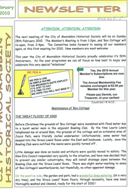
The City of Moorabbin Historical Society was formed c 1960 by a group of Moorabbin residents who were concerned that the history of the area should be preserved. A good response to a call for items related to the historical area of Moorabbin Shire brought donations of a wide variety of artefacts which are now preserved by the current members of CMHS at Box Cottage Museum . Helen Stanley, Secretary of CMHS, began producing a Newsletter for members in April 2007 to provide current information and well researched items of historical interestHelen Stanley has produced a bi-monthly Newsletter, 2007 - 2013, for the members of the City of Moorabbin Historical Society that contains well researched interesting historical items, notification of upcoming events, current advice from Royal Australian Historical Society , Museums Australia Victoria and activities of Local Historical Societies. The Newsletter is an important record of the activities of the CMHS5 x A4 paper printed on 1 side Issue 15 of the bi-monthly, City of Moorabbin Historical Society Newsletter produced by Society member and Secretary, Mrs Helen Stanley in February 2010. Notices for the meeting February 28th , subscriptions due, and this is 50th Anniversary of CMHS. Water flooded Joyce Park, the grounds of the Cottage and a little seeped into Grace Lewis Room in December 2009 when a water main at the neighbouring Bowling Club burst, but little damage occurred and the Glen Eira Council will install drainage pipes between Box Cottage and the Bowling Club. In January, 2 brush tailed possums had taken up residence in the Barn and after failed attempts by Helen and Dennis to move them, Glen Eira Council relocated them. A description of the establishment of Cobb & Co Coaches by Freeman Cobb in 1853, for cartage between Melbourne and the Ports but they soon began transporting people and mail to the gold fields around Victoria. 3 photocopied photographs of Cobb & Co Coaches and 1 photo of the 2 Possums CITY of MOORABBIN HISTORICAL SOCIETY / February 2010 NEWSLETTER city of moorabbin historical society, stanley helen, maynard dennis, melbourne, moorabbin, cheltenham, ormond, bentleigh, market gardeners, pioneers, early settlers, moorabbin shire, box cottage museum, lewis grace, cobb freeman, cobb and co coaches, ballarat, goldfields, gold miners, bendigo, castlemaine, governor latrobe, victoria, sydney road, sutherland alexander, chinese gold miners -
 Flagstaff Hill Maritime Museum and Village
Journal - Record Book, Meteorological Observations, 1947-1948
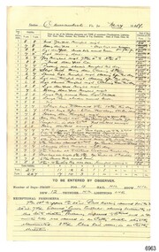
This bundel of twenty pages of meteorological observations covers the period between March 1947 and April 1948 but there are some gaps. The bundle includes handwritten records on pre-printed forms from the Commonwealth Government and brief records on plain paper. There are calculations for monthly totals of information such as rainfall, and there are some comparisons between the years. One of the forms has handwriting in three directions, which is quite unusual. Readings were recorded daily for barometer, temperature and wind. There was also a section for comments on Exceptional Phenomena such as storms and fog. . It was one of the many duties of the Lighthouse Keeper or his Assistant to keep these records and make the mathematical calculations required by the Government. Information gathered from Lighthouse Keepers' letters tells of the large amount of time taken for this detailed work and the lack of payment made for such a responsibility. The quite detailed record for May, June and July 1947 were signed by C Carrington, Harbour Master for Warrnambool. Captain Carrington was responsible to the Harborus Board. He was responsibilite for the fortnightly training of the Warrnambool Lifeboat Crew on the practice of lifesaving and using the Rocket Rescue equipment. These Meteorological Observations are an important accurate record of the local weather since the late 1899s. They are part of Flagstaff Hill's Meteorological Observations collection of over seventy record books dating from the late 19th century. The collected information gives a picture of the weather patterns for the months and seasons, which then allows for warnings of events out of the normal or extreme, such as forecasting floods or droughts.Meteorological Observations for Warrnambool March 1947 to May 1948. A bundle of unbound sheets of paper joined at the top left corner with a metal fastener. The pages are ordered from most recent on top to the oldest on bottom. The older records are on pre-printed forms and include many handwritten details. The more recent records are handwritten on plain paper. There is a line for each day of the month and lines for calculations at the bottom of the page. The handwritten Information includes readings for Barometer, Temperature, Wind and Rain. Printed: "COMMONWEALTH OF AUSTRALIA METEROLOGICAL OBSERVATIONS / Division No. 5, Vic. "flagstaff hill, warrnambool, great ocean road, shipwreck coast, flagstaff hill maritime museum and village, maritime museum, maritime village, meteorological observations, weather records, meteorology, barometer readings, temperature records, barometer records, wind records, rain records, commonwealth of australia, division 5, weather measurement, weather forecast, weather history, carrington, harbour master -
 Ballaarat Mechanics' Institute (BMI Ballarat)
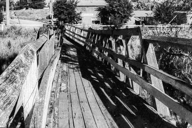
Film - Photograph by Herb Richmond. ca 1971, Skipton- Footbridge Over Emu Creek. No provision on road bridge for foot traffic. Note effect of flood waters
Ballarat History35mm B&W Kodak Plus X Pan Film.ballarat, ballaraat, skipton, footbridge, emu-creek -
 Bendigo Historical Society Inc.
Document - LONG GULLY HISTORY GROUP COLLECTION: CITY OF BENDIGO
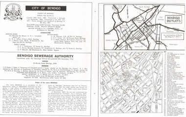
Page with the titled City of Bendigo includes when the County was created, proclaimed a Borough, then a City and a name change, the area, population, swellings and Mayoral Allowance. Darling Ward Councillors were: Cr R L Campbell, The Mayor, Cr N C Jeffrey, and Cr J Pearce. Sutton Ward Councillors, Cr M Petersen, Cr R F Turner, and Cr C Stoltz. and Barkly Ward Councillors, Cr P T Tomkinson, Cr C Davies and Cr P Mansell. Bendigo Sewerage Authority Members: T R Flood, C Stoltz, P Tomkinson, R Campbell, R F Turner, A L Roy, K Houlahan, E Knight, J Bowles, M Brennan, H A Moors and V F Moyle. Also mentioned is the Origin of the name Bendigo. There is a small map of Bendigo Outlet roads and another map with services, attractions, churches, etc.bendigo, history, long gully history group, the long gully history group - city of bendigo, cr r l campbell, cr n c jeffrey, cr j pearce, cr m petersen, cr r f turner, cr c stoltz, cr p t tomkinson, cr c davies, bendigo disposals, cr p mansell, bendigo sewerage authority, t r flood, bendigo city council, a l roy, borough of eaglehawk, k houlahan, shire of strathfieldsaye, e knight, shire of marong, j bowles, shire of huntly, m brennan, h a moors, v f moyle, abednego, john wesley, abednego thompson, battling bendigo, richard sherratt, thomas myers, castleton, sandhurst, military college of sandhurst england -
 Clunes Museum
Photograph
... 3 X COLOUR PHOTOGRAPHS TAKEN AT MT CAMERON ROAD BRIDGE... CAMERON ROAD BRIDGE OF THE FLOODS OF AUGUST TO SEPTEMBER 2010 ...3 X COLOUR PHOTOGRAPHS TAKEN AT MT CAMERON ROAD BRIDGE OF THE FLOODS OF AUGUST TO SEPTEMBER 2010 PHOTOGRAPHS WERE TAKEN ON 12/08/2010 AND 04/09/2010STICKER ON THE BACK OF PHOTOGRAPH: MC. EILEEN BRADSWORTH, CLUNESflood 2010, mt cameron road bridge -
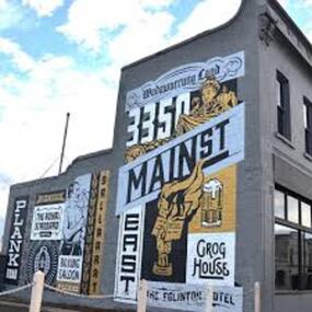 City of Ballarat
Artwork, other - Public Artwork, Travis Price, Main Road Mural by Travis Price, May 2018
... Ballaarat, Gold Fever, The Royal Standard Hotel, Flood..., Flood, Boxing Saloon, Plank Road, Kulin Nation, 3350, Election ...Whilst my main focus for the artwork design was on the Hotels on Main Road, I felt there was an opportunity to tell a broader story of Main Rd and combine/include some interesting pieces of information from many stages of the history of Main Road. Considering that at one point in time there would have been at more than six hotels in this very short section of street….there’s no doubt Main Rd was an epicentre of communication and festivities for the Goldfields of Ballarat. “No matter what luck he had, every miner needed supplies, food and something to entertain him when he was not searching for gold.” Described as being an overcrowded jumble of muddy streets loosely arranged around mining camps...and loud, muddy, colourful and sometimes illicit. I wanted the artwork composition to consist of overlapping images and text to reflect this sense of hustle and bustle. Main Road Mural tells the broader story of the history of Main Road in Ballarat. In 2018, the City of Ballarat commissioned local Ballarat artist Travis Price to create an artwork to align with the Main Road Revitalisation Project and deliver a key component of the storytelling (heritage interpretation) project that spans the length of the shopping precinct. The artwork is featured on a prominent site in the shopping precinct of main road and tells the story of Main Road through depicting key timeline events. Main Road, as its name suggests, was one of the main entries to the mining areas of East Ballarat. It had several names: Main Street before 1858, Plank Road between 1858 and 1868 and Main Road from 1868 onwards. The centre of mining life, it was crowded, prosperous, raucous and dirty. Painted mural on shop wall in Main Road, BallaratBallaarat, Gold Fever, The Royal Standard Hotel, Flood, Boxing Saloon, Plank Road, Kulin Nation, 3350, Election, East, Grog House, The Scandinavian Hotel. Images; Chinese lantern, Pick & Shovel, Miners Licence burning.main road history, ballarat hotels, gold fever, wadawurrung, kulin nation -
Tatura Irrigation & Wartime Camps Museum
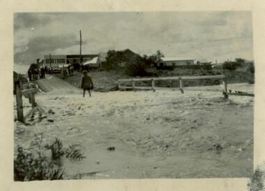
Photograph, 1955 Tatura Floods, 2001
... . The Midland Highway west of the Tatura Undera Road was cut by flood... hogan's farm baldwin road photograph people 1955 Tatura Floods ...In 1955 Ross Street North had to be cut to allow flood waters to relieve the flooding of the Tatura Township. The Midland Highway west of the Tatura Undera Road was cut by flood waters.floods 1955, ross st, midland highway, hogan's farm, baldwin road, photograph, people -
 Sunshine and District Historical Society Incorporated
Photograph (1954) - Flooded Bridge, 1954
1954 Photograph of KOROROIT CREEK in flood and overflowing the DERBY RD BRIDGE in Sunshine. Short time later this bridge was declared unsafe and closed to vehicle traffic. The Sunshine Technical School building is in the background.derby rd bridge, flood, kororoit creek, sunshine technical school, 1954 -
 Nillumbik Shire Council
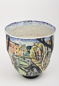
Ceramics (vase): Chris PITTARD, Chris Pittard, Vessel - Flood, 2006
Chris Pittard is a painter who has been working with clay for over 15 years. Pittard studied Fine Arts at RMIT and VCA and has exhibited paintings for a number of years. Pittard divides his time between teaching, drawing and painting and working in the ceramics studio where he creates distinctive pieces. Chris Pittard's ceramic pieces translate the narrative to the vessel. His vessels speak to us about our place and even his personal stories become more universal expressions.In early 2005 there was a flood which raged through the creeks cutting through the Shire of Nillumbik (Eltham). Not usually affected by catastrophe, these surging waters destroyed bridges and threatened roads. When the water subsided along the banks of the creek, trees had fallen, flotsam and jetsam piled up and even weeks later the long grass flattened by the flood continued to map the raging waters flow. The combination of slightly threatening and destructive forces and eerie beauty interested me. This at a time when world events of a far more horrific and tragic nature where presented to us by strangely beautiful coloured photos in our daily papers. These connections may not be obvious but it was certainly something I was thinking about while making this ceramic piece.flood, chris pittard, eltham, nillumbik -
Peterborough History Group
Newspaper articles pertaining to Peterborough from 1990 to 1999
Various newspaper articles kept by Mrs Dawn Irvine, all pertaining to Peterborough - river flooding and quality, concerns over council boundary realignment. Article titles: 6/10/1992 Flooding at Peterborough 28/6/1994 Residents undecided over River 4/7/1994 Letter from Warren Moore. Peterborough is alive, the way residents like it. 26/12/1994 Letter from R. Irvine. Apprehension over changes 17/6/1998 Algae fear prompts call to open Curdies River 13/4/1999 Battlelines on the Curdies 14/4/1999 Peterborough residents urge BHP to find alternative waste disposal optionHistoric overview of the towns' concerns at that time. Seven newspaper cuttings of various sizes all regarding aspects of Peterborough. Includes objection to BHP discharging waste into the Curdies River and flooding. warren moore, ronald irvine, curdies river, moyne council, council boundary realignment, curdies river flooding, floods, peterborough, blue green algae, river quality, bhp waste management, bhp -
 National Wool Museum
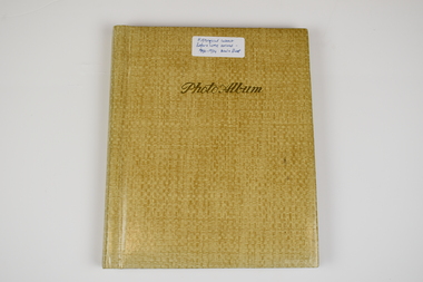
Photo Album, 1930-1934
The Photo Album was created by Hans Beck, who interned with the donor's father (Wilhelm Eckels). The Photo Album depicts wool buying and sheep station related life between 1927-1939. Each photograph has been individually labelled.Straw coloured booklet with gold cursive writing on front cover spelling 'Photo Album'. Inside are 18 pages containing 63 photographs, each individually captioned. Internal pages show signs of age with discolouration, particularly in areas of previous adhesive application.Lettering, Front: Historic Interest Before WME arrived - 1930-1934 Wool & Sheep Photo Album Lettering, Internal by Page: Page 1 - Bottom Left Conner: Table from right:/ O. Hilbert sen. / WW. Richter, W. Ehrig/ Sampler: C. McCarthy/ at desk: E.S. Bottom Right Corner: 1927/ Wool Sample Room/ O. Hilbert/ Terranora Buildings/ Reiby Lane Page 2 - Bottom Middle: 1931/ Opening Sale/ Sydney Page 3 - Bottom Middle: 1934/ Opening Sale/ Sydney Page 4 - Bottom Middle: 1933/ Wool Auctions/ Brisbane Page 5 - Top Left Corner: 1930 Escapade/ Sydney to CAIRNS/ via Bourke, Central/ Queensland, Hinter-/ land & Atherton/ Table Lands Top Right Corner: Dubbo: Main Street/ (1st Night)/ 31.7.1930 Middle Right: 1st Night-"OUT"/ Stranded 11 miles/ from Bourke. (Red/ Dust in Carburettor Bottom Right Corner: Our "ERSKINE'/ hits Culvert &/ breaks both King-/pins. 1 1/2 miles from/ CUNNAMULLA SW-Q. Page 6 - Top Right Corner: "Rosevale Station"/ via Cunnamulla SWQ/ "Gidgi" country/ Gidgi Creak &/ Warrigo R. Middle Left: STAN HILL Page 7 - Middle Top: Blackhall/ Tattersall's Hotel/ Yarning at Cross-/roads. Middle Left: FO Wool Sales/ 22 Horse team Middle Right: Roadsign to:/ ISIS DOWNS &/ Homestead (Fart Page 8 - Middle Top: Muster: 3000 sheep/ Semi-circular/ Shearing shed/ ISIS DOWNS Page 9 - Middle Top: Shearer/ Water Tower/ Counting out/ pens Middle Bottom: Shearers Cook/ Hot Water & Soup/ Cake for Shearing/ Shed Charity Ball Page 10 - Middle Left: Isis Downs Home-/ stead with fire// flood Lookout./ Artesian Borewell Bottom Right: Manager: Moore/ & Alfred Loh-/ mann with kills/ Ducks & Emus Page 11 - Top Middle: PORTLAND DOWNS/ Muster: 10,000/ Sheep Bottom Left: Manager:/ Mr. Luck/ with A.L./Moore Page 12 - Middle Top: ROOKWOOD Station/ near/ HUGHENDEN/ Central NWQ Page 13 - Top Middle: 'HINTERLAND"/ Cattle country/ Spear Grass/ Tracks Bottom Middle: Crossings:/ Creeks: Quick/ Sand/ Rivers: rocky Page 14 - Middle Right: Lyndhurst stat/tion/ Head Stockman Middle Left: -Valley of la-/goons/ Station Bottom Right Corner: Master Atkinson/ saves/ Petrol shortage Page 15 - Top Middle: ATHERTON TABLELANDS/ LAKE BERRINE Middle Centre: Tropical Rainforest/ near/ Lake Berrine Page 16 - Top Middle: ATHERTON TABLELANDS/ Timber Country Bottom Middle Edge: CAIRNS/ Imperial Hotel Page 17 - Hans Beck with/ Betty Hilbert/ Lapstone Hill 1931 wool - transportation, wool sales, wool growing, wool growing agriculture farming, wool industry, wool sales - sydney, wool sales - brisbane, dubbo, 1930, bourke, cunnamulla, isis downs, shearing, shearing - lifestyle, portland downs, muster, hughenden, hinterland, lake berrine, cairns -
 Yarrawonga and Mulwala Pioneer Museum
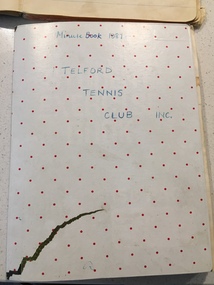
Telford Tennis Club minute books and records, 1920's to 2019
Telford Tennis courts were situated on the Telford Yarrawonga Road, west of the railway line, Telford station and silos. A thriving club existed from early 1920's with players from surrounding areas in early times. balls and tournaments were held as fundraisers. Prominent family names included Stevenson, Chappell, Mulquiney, Thom, Inchbold, Connell. Quinn. There were three teams during the 1960's playing in the Wilby and District Tennis Association ( WDTA) competition. Opponents included Wilby, Almonds, St Mary's, Bundalong, Savernake, Rennie, Roseneath, Burramine. Being in a low lying area the Telford dirt courts were often flooded. At the beginning of the season working bees were held to remove the weeds. mow the surrounds and line the courts During the early 1980's the courts were abandoned and home matches were played at the Yarrawonga Lawn Tennis courts. The club still has a team in the WDTA in 2019. A number of B grade Premierships have been won over the years however A grade premierships have been non existent. The club has always encouraged juniors to play and now the players mostly originate from Yarrawonga. Current President (2019) is Richard Inchbold, Secretary/Treasurer Joan Thom. The Bank account is held at the CMCU. The club is no longer IncorporatedCountry tennis teams provided a social outlet from the farming pursuits of the districtall enclosed in a cardboard box. Minute books 1927 to 2014 (not all complete). Includes photos, paper cuttings, Wilby and District Tennis Association draws, subs books, list of names of those who have played for Telford. Consumer Affairs returns, Incorporation papers, receipt books, some correspondence (later years)see photos -
Whitehorse Historical Society Inc.
Article, Cyclonic rise to the top, 1995
The Acting Chief Executive Officer of the City of Whitehorse, Brian Payne, faced a flood of memories during the recent 20th anniversary of Cyclone Tracy.The Acting Chief Executive Officer of the City of Whitehorse, Brian Payne, faced a flood of memories during the recent 20th anniversary of Cyclone Tracy.The Acting Chief Executive Officer of the City of Whitehorse, Brian Payne, faced a flood of memories during the recent 20th anniversary of Cyclone Tracy.payne, brian, city of whitehorse, council staff -
Whitehorse Historical Society Inc.
Article, Water walkout, 1993
An article in which the City of Nunawading council is blamed for continual flooding in Barbara Street Vermont.An article in which the City of Nunawading council is blamed for continual flooding in Barbara Street Vermont.An article in which the City of Nunawading council is blamed for continual flooding in Barbara Street Vermont.city of nunawading, barbara street, vermont, daly, lyn -
Whitehorse Historical Society Inc.
Article, Basin not the answer, claims flooding victim, 1993
A retarding basin in Scott Street, Vermont is proposed to prevent flooding in Barbara Street, but former resident, Ms Daly is sceptical of its efficiency.A retarding basin in Scott Street, Vermont is proposed to prevent flooding in Barbara Street, but former resident, Ms Daly is sceptical of its efficiency.A retarding basin in Scott Street, Vermont is proposed to prevent flooding in Barbara Street, but former resident, Ms Daly is sceptical of its efficiency.city of nunawading., barbara street, vermont, scott street, vermont, daly, belinda, ward, kelvin -
Whitehorse Historical Society Inc.
Article, Nunawading residents see red over drainage scheme 'waste', 1993
Residents are concerned that the proposed easement drain in Esdale Street will not solve flooding problems.Residents are concerned that the proposed easement drain in Esdale Street will not solve flooding problems.Residents are concerned that the proposed easement drain in Esdale Street will not solve flooding problems.city of nunawading., esdale street, nunawading, springfield road, nunawading, swingler, phillipa, neal, andrew, drainage -
Whitehorse Historical Society Inc.
Article, Flood plan, 1993
... flooding problems in the Fulton Road area. $100,000 will be spent ...$100,000 will be spent by Melbourne Water to solve flooding problems in the Fulton Road area.$100,000 will be spent by Melbourne Water to solve flooding problems in the Fulton Road area.$100,000 will be spent by Melbourne Water to solve flooding problems in the Fulton Road area.melbourne water, fulton road, blackburn south, drainage -
Whitehorse Historical Society Inc.
Correspondence, Documents re P.E. Eriksson property purchase, 1/03/1943
Invoice and receipt - property search for Mrs P.E. Eriksson from Flood & Permezel solicitors, Collins Street. Receipt for deposit from Frank Parker, Real Estate Agent. Title check and plan from Flood & Permezel. Copy, contract of sale - Insurance Policy Coop Insurance Co. Invoice Griffiths Bros, tea merchants Nov 1910 - Jan 1911 for Mrs A. Eriksson. Advice - certificate of title.eriksson, pearl eileen, w. h. flood & permezel, frank parker (real estate agent), warnes road, mitcham no 30, land sales, cooperative insurance company of australia, edgar -
 Whitehorse Historical Society Inc.
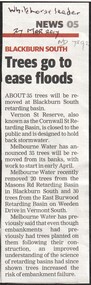
Article, Trees go to ease floods, 2017
Melbourne Water will remove 35 trees from the embankments of the Vernon Street Reserve, also known as the Cornwall Street Retarding Basin, to reduce the risk of embankment failure.trees, blackburn south, vernon street, blackburn, melbourne water -
 Whitehorse Historical Society Inc.
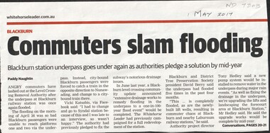
Article, Commuters slam flooding, 2017
The underpass at Blackburn railway station flooded again on the morning of Apr 26th preventing passengers from boarding city bound trains. This is the fifth time it has flooded in the past 4 months.level crossing removal authority, blackburn railway station -
 Ballarat Heritage Services
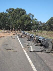
Photograph - Colour, Asphalt on Bridge, Floods, Carisbrook
... Office goldfields Carisbrook flood road damage asphalt Asphalt ...carisbrook, flood, road damage, asphalt -
 Whitehorse Historical Society Inc.
Photograph, Blackburn Bowling Club, 2012
First games played 1926. The Club was then situated in South Parade. Ladies were invited to join in 1927. The yearly fee was 1.10 sterling. In 1933 the green was officially opened by Robert Menzies. The clubhouse was finally completed in the late 1940's. By the 1960's membership had risen to the extent that a new site was needed. A site on the east side of Pakenham Street, south of the creek, was proposed but it was subject to flooding. In 1966, after the flooding of the creek was managed, the South Parade property was acquired and the new greens were ready by September 1966.Coloured photograph of the Blackburn Bowling Club, Pakenham Street Blackburn. Photograph shows rinks in front of the club house - 2012blackburn bowling club, sporting clubs, pakenham street, blackburn -
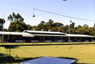
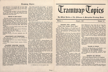 Ballarat Tramway Museum
Magazine, Melbourne and Metropolitan Tramways Board (MMTB), "Tramway Topics" - M&MTB, 1947 and 1948
16 issues of the, "Tramway Topics" - "The Official Bulletin of The Melbourne & Metropolitan Tramways Board", issues 50, 51, 53 to 61, issued between August 1947 and October 1948. All printed on cream coloured paper. Headings of significance are listed below. Common items were; Retiring and Death Gratuities, Appointments and Promotions, long service records. 918.1 - 50 - August 1947 - 4 pages - Comment from London, Scalers in Sydney, Brisbane Services, PAYE to go, Newcastle wants to own the trams, Diesels in favour, Fares in London and Melbourne, Something like a deficit, a remarkable record (substations), Work of Testing Department, Accidents are Expensive, and Transport Operations Indicted (National City Lines - USA) 918.2 - 51 - Sept. 1947 - 4 pages - Our SW6 tram, Transport in the US, Conductresses again, How bus costs have risen, Footscray Extensions, Of Course you are good (drivers and driving), How Fares Go, 40-Hour week. 918.3 - 53 - November 1947 - 4 pages - No increase in fares, an unusually interesting tram (Glasgow), alcohol and driving do not mix, pedestrian crossing case, how wages have increased, Russia prefers trams, Sydney's "Honesty" joke, Higher Fares wanted, Tramcars as hearses, an editor on Trolley buses, buses lead - but at a cost (Leicester), the Non paying passenger (Sydney) 918.4 - 54 - December 1947 - 4 pages - Christmas 1947 (Chairman's notes on the future), New Stockholm tram, according to use and wont - Birmingham, Trams in the USA, Board re-appointed, Buses few, so coaches are hired (London), transport from Footscray, "Philadelphians must have the best" - so they are given trams!, The Merri Creek Bridge and appreciations. 918.5 - 55 - March 1948 - 4 pages - That 4/- doubts arising over the 5-day week, Buses carried pick-a-back, Sydney to lose L500,000 this year, Trolleybuses, Rapid transit with PCC trams, another compliment (rosters in Perth), the bill for it all (Melbourne tram strike), an Extraordinary award (Washington DC), Prison tram's last load (Sydney), Douglas horse trams, Lord Ashfield, Glasgow's all night buses. 918.6 -56 - April 1948 - 4 pages - The Board's ambassadors (MMTB Conductors), Brisbane's bus routes, Another deficit in sight (Liverpool UK), Poor Paris, The resilient wheel, the 5-day week rosters, a subway and its costs (Detroit), PCC's in Belgium, South London Trams. 918.7 -57 -May 1948 - 4 pages - Spread of Hours Payment - 5 day week, weak breaks, Buses multiply - losses expand (Manchester UK), Static Electricity, L750,000 deficit in Sydney, praise for conductresses, no purchase by Newcastle, a loss at Adelaide, Transport in Switzerland, Denmark's giant bus, new trams for Glasgow, Grants for sports, single deckers out of favour (UK buses), Transport by Water (London). 918.8 - 58 - June 1948 - 8 pages - Stirring up strife (Melb.) No profit - no sharing (Kansas City), Just why - prices and fares in the US, MMTB staff needs from 5 day week, Section fares in the US, trams at L5,500 each (Sheffield), The unfinished dance (Perth and Hay St.), Thanks from Bristol, Interest in Melbourne trams (letters to the Board), Adelaide's Deficit, Fares up in Sydney and Adelaide, Moscow transport, No trolleybuses thankyou in Belgium, thanks to the Traffic staff, the Late Inspector Boardman, 24,000 irregularities (passengers), Sth London trams, Melbourne's trams amazing, Winnipeg's transport Growth and Standing passengers - London. 918.9 - 59 - July 1948 - 4 pages - The Red Light - RACV and red lights on trams, A request from Argentina,, where our SW6's are, the last 5c fare (New York), Work in the Fog, Traffic headaches in the US, Brisbane's Streamlined tram, Safety glass, Now for La Trobe St. The Tramways Band (South St.), Transport Losses in Sydney. 918.10 - 60 - August 1948 - 4 pages - from Pretoria (Comments on Melbourne), Buses with sliding Doors (OPS1), PCC trams, trams of the future (Glasgow), new trams in Rome, Clearing up the Parking Problem (Sacramento), Fantastic figures - world tram car figures - anti tram, Trainer Drivers, the railway trams and disaster to Liverpool trams, Monte Video trams purchased. 918.11 - 61 - September 1948 - 4 pages - The Year's Work (Melbourne), How Absurd (transport management), items from Britain, Tramway Band News, Food from Melbourne (to Scotland floods), London's Extraordinary traffic, New trams for The Hague, who are the road hogs, the La Trobe St. extension, out clothing factory, Preston Workshops, Toil on the tracks, how the money comes in (fares distribution). 918.12 - 62 - October 1948 - 4 pages - Melbourne's tram fares, Bourke St., Sydney's Street Transport, Scientist or Baker (London), Trolleybuses out of favour, London's poor bus fleet, tram and bus fares, The band at Wattle Park, Madras tramway deal, 121 decide for 6000 (Sydney Sunday trams), Preston workshops, A Engineer's tribute, Was the Street Quiz on trams faked? (The Sun). 918.3 - No. 31 - September 1945 - Year in review - trams more reliable than buses, loss on buses to munitions and Fisherman's bend, ticket checking, Hawthorn clothing factory SW6 trams construction, news from cities in Europe, sub-stations. 918.14 - 64 - September 1949 - higher operating expenses and revenue, school children behaviour, headway recording system - communication issues, golf at Wattle Park, Mr Bell lives in Riversdale Rd. 918.15 - 67 - December 1949 - Record Payment to Consolidated Revenue, payment to MFB etc, flat fares, Latrobe St extension - delayed, fare concessions - who pays, 918.16 - 68 - January 1950 - Bourke St conversion - Risson looking for an early start, fitting of radios to MMTB vehicles, Resilient wheels 918.4 - on top edge in pencil is "Mr Russell", and 918.10 ditto.trams, tramways, mmtb, melbourne, tramways -
 Kew Historical Society Inc
Print - Walmer Street Foot Bridge, 1901
Photographic print of the Walmer Street Bridge. The view of the Bridge is from the Abbotsford side of the Yarra. A section of pipe on the near side of the bridge is a remnant of the irrigation pipes that carried water from above Dight's falls to the Melbourne Botanic Gardens. The former bridge, constructed in 1896 was swept away in the 1901 Flood. It has two major brick piers while the remainder of the trestle supports are metal. The original photograph from which this copy was made was taken after 1901 as it shows the second bridge under construction. Houses in Young Street, Kew, can be seen on the far side of the river.Reverse: " Walmer St footbridge 1901 being repaired after flood / Constructed 1892 substantially renewed in 1901 and in 1928 / Rebuilt in 1977 by Kew Council aided by State funding. Won for designer Martin Aylard a New Zealand award presented by the timber Research & Development Assoc / Site of Simpsons Road passenger foot ferry". bridges - yarra river -- kew (vic.), walmer street bridge -- kew (vic.) -
 Kew Historical Society Inc
Photograph - Flooding of the Yarra River in North Kew, 1934
North Kew, now divided between Kew and Kew East, bordered the Yarra River. As such, it was a region subject to flooding in the Yarra Valley. Development beyond this point (ie Kellett Grove) was limited by the City of Kew's planning regulations. Prior to urban development, the area since European settlement and the first land sales in the district in the 1840s, had been used for dairy farming. Small sepia snapshot of floodwaters taken from near Willsmere Road, in what was then known as North Kew. The point of view is looking towards Fairfield. In the foreground are two figures viewing a group in a rowboat in the middle of the flooded river. Semi-submerged street lighting indicates that entire streets had been. overwhelmed by the flood waters. Verso: WILLSMERE ROAD NORTH KEW / Stamped 3 163yarra river -- north kew, floods -- yarra valley, floods -- north kew, floods -- 1934, natural disasters -- kew, willsmere road -
 Kew Historical Society Inc
Photograph - Flooding of the Yarra River in North Kew, 1934
North Kew, now divided between Kew and Kew East, bordered the Yarra River. As such, it was a region subject to flooding in the Yarra Valley. Development beyond this point (ie Kellett Grove) was limited by the City of Kew's planning regulations. Prior to urban development, the area since European settlement and the first land sales in the district in the 1840s, had been used for dairy farming. Small sepia snapshot of floodwaters in North Kew. The point of view is of two houses belonging to local families that were surrounded by floodwater. Verso: HYATTS HOUSE / WILLSMERE ROAD / Stamped 3 163yarra river -- north kew, floods -- yarra valley, floods -- north kew, floods -- 1934, natural disasters -- kew, willsmere road -
 Kew Historical Society Inc
Photograph - Flooding of the Yarra River in North Kew, 1934
North Kew, now divided between Kew and Kew East, bordered the Yarra River. As such, it was a region subject to flooding in the Yarra Valley. Development beyond this point (ie Kellett Grove) was limited by the City of Kew's planning regulations. Prior to urban development, the area since European settlement and the first land sales in the district in the 1840s, had been used for dairy farming. Small sepia snapshot of floodwaters in North Kew, from the rear of 8 Kellett Grove. Verso: OUR BACKYARD / Stamped 52yarra river -- north kew, floods -- yarra valley, floods -- north kew, floods -- 1934, natural disasters -- kew, willsmere road -
 Kew Historical Society Inc
Photograph - Grandfather and granddaughter in the yard of 8 Kellett Grove, Kew, 1934
North Kew, now divided between Kew and Kew East, bordered the Yarra River. As such, it was a region subject to flooding in the Yarra Valley. Development beyond this point (ie Kellett Grove) was limited by the City of Kew's planning regulations. Prior to urban development, the area since European settlement and the first land sales in the district in the 1840s, had been used for dairy farming. Vivid photograph contrasting domestic life and relationships with natural disasters such as the flood of 1934.Small sepia snapshot of a grandfather and granddaughter sitting in the backyard of 8 Kellett Grove, North Kew, with the floodwaters stretching behind them.Verso: GRANDDAD AND I IN BACKYARDyarra river -- north kew, floods -- yarra valley, floods -- north kew, floods -- 1934, natural disasters -- kew, willsmere road -
![The Punt, Echuca / [by] Nicholas Caire, circa 1876](/media/collectors/550653872162f11fb04854aa/items/57825721d0cdd1176ce1789a/item-media/57825765d0cdd1176ce19829/item-fit-380x285.jpg) Kew Historical Society Inc
Kew Historical Society IncPhotograph, Anglo-Australasian Photographic Company, The Punt, Echuca, c. 1876
Nicholas Caire was born on Guernsey in the Channel Islands in 1837. He arrived in Adelaide with his parents in about 1860. In 1867, following photographic journeys in Gippsland, he opened a studio in Adelaide. From 1870 to 1876 he lived and worked in Talbot in Central Victoria. In 1876 he purchased T. F. Chuck's studios in the Royal Arcade Melbourne. In 1885, following the introduction of dry plate photography, he began a series of landscape series, which were commercially successful. As a photographer, he travelled extensively through Victoria, photographing places few of his contemporaries had previously seen. He died in 1918. Reference: Jack Cato, 'Caire, Nicholas John (1837–1918)', Australian Dictionary of Biography.An original, rare photograph from the series 'Views of Victoria: General Series' by the photographer, Nicholas Caire (1837-1918). The series of 60 photographs that comprise the series was issued c. 1876 and reinforced a neo-Romantic view of the Australian landscape to which a growing nationalist movement would respond. Nicholas Caire was active as a photographer in Australia from 1858 until his death in 1918. His vision of the Australian bush and pioneer life had a counterpart in the works of Henry Lawson and other nationalist poets, authors and painters.Views of Victoria (General Series) No.34; ‘The Punt, Echuca’; Albumen silver photograph | Photo on card with Title and Description on reverse | Mounted 24 x 30 cm; Photo 12 x 17 cm.On Reverse: ‘The subject of this illustration is the principal crossing-place on the River Murray at Echuca, as regards the ordinary road traffic from the district of Riverina, New South Wales. After the periodical floods, the Punt is found to be insufficient for the large traffic; but this inconvenience will not be found to occur again to any great extent, as the new Railway Bridge from Moama will considerably lessen the road traffic through the Township of Echuca.’nicholas caire (1837-1918), echuca (vic), landscape photography -
 Kew Historical Society Inc
Plan, Studley Park Estate, 1910
Prue Sanderson, in her groundbreaking ‘City of Kew Urban Conservation Study : Volume 2 - Development History’ (1988), summarised the periods of urban development and subdivisions of land in Kew. The periods that she identified included 1845-1880, 1880-1893, 1893-1921, 1921-1933, 1933-1943, and Post-War Development. These periods were selected as they represented periods of rapid growth or decline in urban development. An obvious starting point for Sanderson’s groupings involved population growth and the associated economic cycles. These cycles also highlighted urban expansion onto land that was predominantly rural, although in other cases it represented the decline and breakup of large estates. A number of the plans in the Kew Historical Society’s collection can also be found in other collections, such as those of the State Library of Victoria and the Boroondara Library Service. A number are however unique to the collection.The Kew Historical Society collection includes almost 100 subdivision plans pertaining to suburbs of the City of Melbourne. Most of these are of Kew, Kew East or Studley Park, although a smaller number are plans of Camberwell, Deepdene, Balwyn and Hawthorn. It is believed that the majority of the plans were gifted to the Society by persons connected with the real estate firm - J. R. Mathers and McMillan, 136 Cotham Road, Kew. The Plans in the collection are rarely in pristine form, being working plans on which the agent would write notes and record lots sold and the prices of these. The subdivision plans are historically significant examples of the growth of urban Melbourne from the beginning of the 20th Century up until the 1980s. A number of the plans are double-sided and often include a photograph on the reverse. A number of the latter are by noted photographers such as J.E. Barnes.Coloured lithograph of a subdivision plan of the Studley Park Estate, bordered by Yarra, Willsmere Road and the Outer Circle Railway line. The estate was listed in 1910 and was the subject of a planning dispute between the developer and the Town of Kew in relation to flood levels and the suitability of the land for housing. In many cases the names of streets were subsequently changed. The layout was also affected by the creation of the Eastern Freeway. A newspaper report of the day described the subdivision as a: "GOLDEN OPPORTUNITY. We are pleased to submit for PRIVATE SALE that magnificent ESTATE, situated only 4 1/2 miles from the Melbourne General Post Office, STUDLEY PARK ESTATE. KF/NV. Doubtless the CHEAPEST LAND EVER OFFERED having extensive frontages to the prettiest spot on the River Yarra and the National Park, commanding lovely river and landscape views, and acknowledged to be the finest land available so close to the city. The PRICES ARE EXTREMELY MODERATE; The TERMS ARE SIMPLY MARVELLOUS. NO DEPOSIT. NO DEPOSIT. NO DEPOSIT. Allotments and prices to suit everyone."subdivision plans - kew, studley park estate