Showing 439 items
matching flowes
-
 Kiewa Valley Historical Society
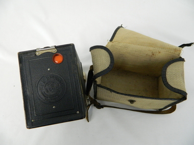
Bag Camera, circa 1920s
This item was manufactured in a period where the cheapest containers for portable equipment was canvas. The market place for cheap cameras was still restricted to European, England and its colonies. It was well before the post World War II explosion of the Asian manufacturing juggernaut.This item shows one of the most popular avenues of not only bringing new "modern" age equipment into the Kiewa Valley but also providing the local market with actual overseas inexpensive merchandise. It was a time when the new European fashion and "new age" equipment took years to permeate into regional Australia. The world, through Australia eyes, was still a very large planet and supply of "modern" lifestyle equipment emphasised the geographic isolation of Australia. Post World War II emigrants and an increasing flow of tourists to Australia provided the contact needed by rural settlements to open up not only their social contacts but lifestyle activities.Canvas, yellow, cream in color and with a weave pattern on the external side. It has stitched brown laminated fabric boarders containing all ends and corners. A flap opening top fastened on one side by a large press stud (15mm). A brown coloured leather carry strap (adjustable and 10mm wide) fasted at either of the longitudinal ends of the bag.camera, case photography, hobby, personal equipment -
 Kiewa Valley Historical Society
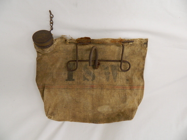
Bag Canvas Water, Circa 1950
This extract from an advertisement in the Sydney Morning Herald newspaper of 1/12/1959 places the era in which this water bag was prolific throughout rural Australia. " ABERDEEN CANVAS GOODS for the man on the land here is Australia's most useful, convenient and hygienic water bag. Its special unbreakable plastic nozzle is fitted with a perforated filter strainer. Made from long flax canvas, its universal handle enables it to be hung on bumper bar, wire fence or on hook or nail" The availability of clean cool drinking water in remote rural locations was essential for survival under the blistering Australian summer sun. This was in a pioneer era when transport, roads and convenience stores were ,in a lot of "outback" Australia, in short supply and survival was dependent upon what could be carried by vehicle or pack horse.When the Kiewa Hydro Electricity Scheme became a reality, the use of the water bag was one of the essential personal items of survival given to each person working in the forests and on and in the high plains environment. Even in an outside stationary work place the availability of cool clean water was a prerequisite. The canvas water bag allowed any wind or airflow to cool down the water, even on very hot days, to provide a refreshing and throat quenching supply of water. These bags could be fastened onto the front of vehicles or hanging from shady tree branches thereby permitting air flow around the bag. During the "wearing in" period the residual taste from the canvas was fairly strong, this became considerably less as time and a half moved on. This "Aberdeen" long flax canvas water bag is held together on two sides and the top by strong heavy cotton stitching. The iron fashioned carrying handle has, protruding from its top elevation ,a very strong hook (well in excess of the bags' weight requirement). At the top, of the bag, and on one side only, is a brown coloured bakelite spout (with an inbuilt filter) protruding upwards. This spout has its matching , screw on, lid complete with attachment chain (not fixed at the handle end)On the front of the bad and stenciled in bold lettering, "ABERDEEN" and directly below "Travellers" and below this "FILTER BAG". Below this are two parallel black lines enclosing an ochre coloured band(12mm wide) running around the bottom section of the bag. Below this band is stenciled the number 14 in black (25mm high) figures. The spout lid has stamped on the top surface and within the outline of Australia, "ABERDEEN FILTER WATER BAG". Above this and close to the edge of the lid is pressed "PAT. No 9149/32 and down at the bottom rim is stamped "RD. No. 9870". canvas, water bag, water container, camping equipment, survival pack -
 Eltham District Historical Society Inc
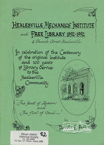
Book, Healesville Mechanics' Institute and Free Library 1892-1992, 4 Church Street, Healesville : in celebration of the centenary of the original institute building and 100 years of library service to the Healesville community : "the feast of reason and the flow of soul" / Pamela E. Firth, 1992
Paperback; xvi, 70 p. : ill. ; 30 cm.ISBN 0646113569mechanics' institute, healesville, libraries -
 Orbost & District Historical Society
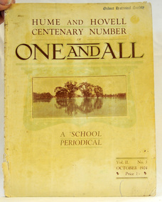
magazine, Clothier & Co, One And All, 1924
This magazine was circulated amongst the pupils, parents, and teachers of the Beechworth Inspectorate, North-East Victoria. This magazine is Vol. 2, no. 3 (Oct. 1924), Hume and Hovell Centenary Number.School magazines were the forerunners of today's school newsletters and were generally published annually. They are contemporary records of the students and staff of the school and usually contain examples of the students' work.This one, published to commemorate the centenary contains information on the Hume and Hovell expedition the purpose of which was to find new grazing land in the south of the colony, and also to find an answer to the mystery of where New South Wales's western rivers flowed. At the centenary of Hume and Hovell exploration in 1924 a committee was formed to co-ordinate and organise local celebrations along the route from Albury to Corio Bay. A roadside cairn was unveiled near Beechworth.A stapled school magazine with a cream coloured cover. It has an illustration of a river and trees reflected in the water on the front. The title, "ONE AND ALL" is at the top in black print. It has " Hume and Hovell Centenary Number" above the title.education-beechworth school-magazine-one-and-all -
 Marysville & District Historical Society
Booklet (Item) - Information booklet, Artworkz Tourism, The Big Culvert, Unknown
An information booklet that was produced as a guide to The Big Culvert.An information booklet that was produced as a guide to The Big Culvert. The Big Culvert is a historic granite and bluestone arch along the Yarra Track, a major route to Melbourne through the 1800s. Built in 1870 and a major piece of infrastructure for its time, the heritage listed culvert allowed water to flow under often-flooded the road. The Yarra Track is the former name of the gold fields road from Healesville to the Woods Point and Jordan Goldfields, in Victoria, Australia. A direct route via the Yarra River and the Great Divide was discovered by Rieck in September 1862 and became known as the Yarra Track. Early in 1863, the Victorian Government decided to construct a 193-kilometre (120 mile) road along the route. Its original width varied between 4 and 6 metres (12 and 20 feet), and was designed to accommodate horse-drawn vehicles. The Track involved the climbing of the Black Spur, descent into the Acheron Valley, and then through Marysville to the Cumberland where it followed the existing route.the big culvert, yarra track, victoria, healesville, wood's point goldfields, jordan goldfields, black spur, acheron valley, cumberland valley -
Marysville & District Historical Society
Flyer (Item) - Information flyer, Artworkz Tourism, The Big Culvert, 26-03-2016
An information flyer that was produced as a guide to The Big Culvert.An information flyer that was produced as a guide to The Big Culvert. The Big Culvert is a historic granite and bluestone arch along the Yarra Track, a major route to Melbourne through the 1800s. Built in 1870 and a major piece of infrastructure for its time, the heritage listed culvert allowed water to flow under often-flooded the road. The Yarra Track is the former name of the gold fields road from Healesville to the Woods Point and Jordan Goldfields, in Victoria, Australia. A direct route via the Yarra River and the Great Divide was discovered by Rieck in September 1862 and became known as the Yarra Track. Early in 1863, the Victorian Government decided to construct a 193-kilometre (120 mile) road along the route. Its original width varied between 4 and 6 metres (12 and 20 feet), and was designed to accommodate horse-drawn vehicles. The Track involved the climbing of the Black Spur, descent into the Acheron Valley, and then through Marysville to the Cumberland where it followed the existing route.the big culvert, yarra track, victoria, healesville, wood's point goldfields, jordan goldfields, black spur, acheron valley, cumberland valley -
 Marysville & District Historical Society
Photograph (Item) - Black and white photograph, Unknown
A black and white photograph taken at the unveiling of the sign placed at The Big Culvert.A black and white photograph taken at the unveiling of the sign placed at The Big Culvert. The Big Culvert is a historic granite and bluestone arch along the Yarra Track, a major route to Melbourne through the 1800s. Built in 1870 and a major piece of infrastructure for its time, the heritage listed culvert allowed water to flow under often-flooded the road. The Yarra Track is the former name of the gold fields road from Healesville to the Woods Point and Jordan Goldfields, in Victoria, Australia. A direct route via the Yarra River and the Great Divide was discovered by Rieck in September 1862 and became known as the Yarra Track. Early in 1863, the Victorian Government decided to construct a 193-kilometre (120 mile) road along the route. Its original width varied between 4 and 6 metres (12 and 20 feet), and was designed to accommodate horse-drawn vehicles. The Track involved the climbing of the Black Spur, descent into the Acheron Valley, and then through Marysville to the Cumberland where it followed the existing route.Unveiling of sign/ at "Big Culvert" In front Max Cockerrell and - Rear: second back Geoff Pope R.H.S. rear: Nancy "/ Anne "the big culvert, yarra track, victoria, healesville, wood's point goldfields, jordan goldfields, black spur, acheron valley, cumberland valley -
 Marysville & District Historical Society
Photograph (Item) - Colour photograph, 20-09-2008
A colour photograph of the entrance to The Big Culvert.A colour photograph of the entrance to The Big Culvert. The Big Culvert is a historic granite and bluestone arch along the Yarra Track, a major route to Melbourne through the 1800s. Built in 1870 and a major piece of infrastructure for its time, the heritage listed culvert allowed water to flow under often-flooded the road. The Yarra Track is the former name of the gold fields road from Healesville to the Woods Point and Jordan Goldfields, in Victoria, Australia. A direct route via the Yarra River and the Great Divide was discovered by Rieck in September 1862 and became known as the Yarra Track. Early in 1863, the Victorian Government decided to construct a 193-kilometre (120 mile) road along the route. Its original width varied between 4 and 6 metres (12 and 20 feet), and was designed to accommodate horse-drawn vehicles. The Track involved the climbing of the Black Spur, descent into the Acheron Valley, and then through Marysville to the Cumberland where it followed the existing route.the big culvert, yarra track, victoria, healesville, wood's point goldfields, jordan goldfields, black spur, acheron valley, cumberland valley -
 Federation University Historical Collection
Booklet, Thomas Stephen Hart, The Highlands and Main Divide of Western Victoria, 1907, 12/12/1907
Thomas S. Hart was a teacher at the Ballarat School of Mines, and a member of the Ballarat Field Naturalists ClubArticle with illustrations published by the Royal Society of Victoria by Thomas S. Hart. The following plates are included: Fig 1. The Main Divide and some of the transverse ridges Fig 2. Hills on and near the Divide at the Ercildoun and Ascot Gaps Fig. 3. Profile of the Divide at Ascot Gap. Fig. 4. Sketch of the Hills west and north-west from Mt Buninyong - - The divide in Ascot Gap from Mt Blowhard (Serra Range, Mt William, Mt Ararat, Larne Gerin, Ben Major, Mt Cole, Mt Misery, Mt Bolton) Fig. 5. Diagram to illustrate the possible courses of the leads south of the present Divide - Burrumbeet Basin (Smythesdale, Ballarat, Lal Lal , Mt Doran, egerton, Parwan Creet, Rowsley Fault, Eastern Plateau) Fig. 6. Diagramatic cross section of the grampians, south of Hall's Gap. Profile of the Pyranees, from maiden Hill - Diagramatic Section of the Grampians south of Hall's Gap. (Mt Cole, Mt Mitchell, Ben Major, Ben More, Avoca Hill, Hall's Gap.) Fig. 7. Profile of the Pyrenees as seen from Maiden Hill near Waubra.thomas hart, thomas s. hart, ballarat school of mines, ballarat field naturalists club, royal society of victoria, western victoria, ballarat, great dividing range, mt william, volcano, volcanic plains, waterways, lal lal basin, yarrowee creek, ballarat common, lava flow, wendouree, warrenheip, ballarat plateau, mt elephant, grampians, t.s. hart, mt buangor, mt beckworth, mt misery, mt bolton, lal lal iron ored, mt ararat, mt wiliam, mt cole, burrumbeet, mt warrenheip, daylesford, waubra, ercildoun gap, smythesdale, lal lal falls, parwan valley, burrumbeet creek, staffordshire reef, pyranees, bacchus marsh, rowsley fault, ben nevis, avoca hill, landsborough hill, mt blowhard, weatherboard, mclean's hill, fyan's creek, thomas stephen hart, lal lal -
 Federation University Historical Collection
Book, Department of Infrastructure, Regional Matters: An Atlas of Regional Victoria, C2003
Green soft covered book including chapers on population, jobs and industry, housing, road and rail transport, health services, education, and water resourcesvictoria, regional victoria, population, migration flow, jobs, industry, export, food production, housing, rail, roads, health, education, qualifications, water, irrigation -
 Monbulk RSL Sub Branch
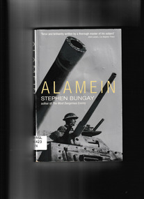
Book, Aurum Press, Alamein, 2003
Stephen Bungay's Alamein is a trenchant re-examination of an event now cloaked in myth. Though the propaganda of the time focused on personalities, this was a desert war, he reveals, determined largely by logistics. In a conflict that for two years had ebbed and flowed along the North African littoral, victory was always going to go to the side that mastered its supply lines - in Britain's case not least by withstanding the epic siege of Malta. He also gets beyond the polemics and eulogies of many past writers in re-assessing Alamein's chief protaganists, Montgomery and Rommel, to show how it was precisely the most unattractive side of Montgomery's character that was needed to transform the Eighth Army into a force capable of fighting a battle it could win.Index, bibliography, notes, ill, maps, p.266.non-fictionStephen Bungay's Alamein is a trenchant re-examination of an event now cloaked in myth. Though the propaganda of the time focused on personalities, this was a desert war, he reveals, determined largely by logistics. In a conflict that for two years had ebbed and flowed along the North African littoral, victory was always going to go to the side that mastered its supply lines - in Britain's case not least by withstanding the epic siege of Malta. He also gets beyond the polemics and eulogies of many past writers in re-assessing Alamein's chief protaganists, Montgomery and Rommel, to show how it was precisely the most unattractive side of Montgomery's character that was needed to transform the Eighth Army into a force capable of fighting a battle it could win.battle of alamein - 1942, world war 1939-1945 - campaigns - north africa -
 Monbulk RSL Sub Branch
Book, Bison Books, Battle of Britain, 1990
Charts the ebb and flow of one of the most important battles of World War TwoIndex, ill, maps, p.80.non-fictionCharts the ebb and flow of one of the most important battles of World War Twobattle of britain, world war 1939-1945 - aerial operarions - britain -
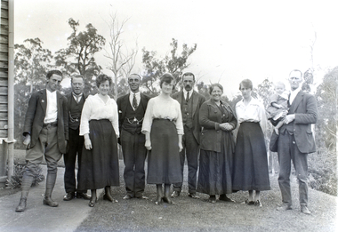 Melbourne Water
Transparency, Staff and Chauffeurs at the O'Shannassy Weir Quarters, 8th April, 1921
The O'Shannassy Weir was a small Weir created in 1911 and completed in 1913, and was the originating point of outflow into the Aqueduct. In 1928, it was replaced by the much larger O'Shannassy Reservoir. The Weir had water moving along the Aqueduct to the Surrey Hills Reservoir. Many structures at the Weir precinct have survived and remain in-situ.The O'shannassy Weir and Aqueduct contains a wide range of intact and diverse features. This demonstrates the way in which the Board constructed and managed the water supply that flowed through farmland and forest areas subject to timber milling. The caretakers residences that are located along the aqueduct were utilised by caretakers who were responsible for maintaining one of their four sections of the channel. This transparency is significant for its historic association to the establishment of the weir and to those who worked on the project, and at the quarters. weir, o'shannassy, aqueduct, reservoir, melbourne water, mmbw, staff -
Moorabbin Air Museum
Plan (item) - Project plans for aircraft construction, Flow Chart No.1
-
Moorabbin Air Museum
Manual - CAC Commonwealth Aircraft Corporation, rolls royce nene Avon 1 100 200series Volume 2 air flow oil pumps overhaul quality control
-
 National Vietnam Veterans Museum (NVVM)
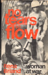
Book, Briand, Rena, No Tears to Flow: Woman at War (Copy 2)
The Vietnam problem is not simply defined by clashes of the Ho Chi Minh regime against supporters of whoever is currently in charge of the South.The Vietnam problem is not simply defined by clashes of the Ho Chi Minh regime against supporters of whoever is currently in charge of the South. 1961-1975 - personal narratives, australian, vietnam war, 1961-1975 - women, ho chi minh -
 National Vietnam Veterans Museum (NVVM)
Book, No Tears to Flow: Woman at War
The Vietnam problem is not simply defined by clashes of the Ho Chi Minh regime against supporters of whoever is currently in charge of the South.The Vietnam problem is not simply defined by clashes of the Ho Chi Minh regime against supporters of whoever is currently in charge of the South. 1961-1975 - personal narratives, australian, vietnam war, 1961-1975 - women -
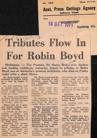 Robin Boyd Foundation
Newspaper - Clipping, Advertiser (Geelong), Tributes flow in for Robin Boyd, 18.10.1971
This article contains an announcement of Robin Boyd's death on Friday 16th October and gives a short summary his career, including tributes for many people, including Premier Sir Henry Bolte.Image/RVIA on top left in pencilwalsh st library -
University of Melbourne, Burnley Campus Archives
Document, Resuscitation flow chart, c. 1980
Instructions for resuscitation of unconscious victimfirst aid, emergency -
 Nillumbik Shire Council
Photograph: Dena ASHBOLT (b.UK, arrived 1982 AUS), Dena Ashbolt, Waking Time, 2012
'Waking Time' is part of the series ' So when do you throw the flowers out?', which exhibited at Melbourne's Alcaston Gallery from 8 May - 1 June 2012.In this series Dena Ashbolt used photographic pigment prints, video and Raku Nu ceramic funery urn drawings, to explore time as evidenced by movement and references the beauty of aging. Ashbolt has a continuing interest engaging with the concepts of time, its flow and passing - as evident in this series. Ashbolt has been a regular finalist at the Nillumbik Prize Contemporary Art and in 2009 was awarded the Prize for the video drawing 'Wet Feet Under the Pier'. Ashbolt is a inter-disciplinary artist whose practice ranges from photography and printmaking through to filmmaking and collaborative performance projects.Pigment Print on Hahnemuhle Paper Edition of 7AK18136 PNT817dena ashbolt, photographic print -
 Nillumbik Shire Council
Photograph: Dena ASHBOLT (b.UK, arrived 1982 AUS), Dena Ashbolt, Countless Daughters, 2012
'Countless Daughters' is part of the series ' So when do you throw the flowers out?', which exhibited at Melbourne's Alcaston Gallery from 8 May - 1 June 2012In this series Dena Ashbolt used photographic pigment prints, video and Raku Nu ceramic funery urn drawings, to explore time as evidenced by movement and references the beauty of aging. Ashbolt has a continuing interest engaging with the concepts of time, its flow and passing - as evident in this series. Ashbolt has been a regular finalist at the Nillumbik Prize Contemporary Art and in 2009 was awarded the Prize for the video drawing 'Wet Feet Under the Pier'. Ashbolt is a inter-disciplinary artist whose practice ranges from photography and printmaking through to filmmaking and collaborative performance projects. Pigment Print on Hahnemuhle Paper Edition of 7AK18137 PNT809photographic pigment prints, dena ashbolt -
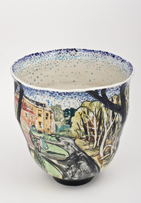 Nillumbik Shire Council
Ceramics (vase): Chris PITTARD, Chris Pittard, Vessel - Flood, 2006
Chris Pittard is a painter who has been working with clay for over 15 years. Pittard studied Fine Arts at RMIT and VCA and has exhibited paintings for a number of years. Pittard divides his time between teaching, drawing and painting and working in the ceramics studio where he creates distinctive pieces. Chris Pittard's ceramic pieces translate the narrative to the vessel. His vessels speak to us about our place and even his personal stories become more universal expressions.In early 2005 there was a flood which raged through the creeks cutting through the Shire of Nillumbik (Eltham). Not usually affected by catastrophe, these surging waters destroyed bridges and threatened roads. When the water subsided along the banks of the creek, trees had fallen, flotsam and jetsam piled up and even weeks later the long grass flattened by the flood continued to map the raging waters flow. The combination of slightly threatening and destructive forces and eerie beauty interested me. This at a time when world events of a far more horrific and tragic nature where presented to us by strangely beautiful coloured photos in our daily papers. These connections may not be obvious but it was certainly something I was thinking about while making this ceramic piece.flood, chris pittard, eltham, nillumbik -
 Nillumbik Shire Council
Public Art: Robert BAINES (b.1949, Melb, Aus), Robert Baines, Transaction (Location: entrance, Nillumbik Shire Council Offices, Civic Drive, Greensborough), 1994
The site specific sculpture is located at the entry to the office of Nillumbik Shire Council. It was commissioned in 1994 by the Shire of Diamond Valley for their 20 year celebration. Baines was chosen from a short list of three artists. He is an internationally renowned artist, particularly in the field of gold and silver smithing. 'Transaction' takes on the visual and aesthetic vocabulary of its surroundings. It is a statement of the geometry and idiosyncrasy of its immediate site. The series of arcs are reinterpreted into longitudinal curves in the sculpture. It is a transaction between the place and the anticipated entry to the building. The title also suggests the flow of civil and administrative procedures that take place daily within the Shire's offices. A large cascading form in stainless steel. Multiple rows of concave dishes set on long steel stems, which progressively increase in size as they rise in height. The work plays elaborately with perspective, and its repeated shapes are arranged in a orderly mathematical series. It faces a wheelchair ramp lined with polished steel rails, and is integrated with the architectural features of its forecourt setting, for which it was designed. The piece is sited in a small garden area and can be viewed from within the building's foyer. In bright sunlight, its dish-shapes cast elliptical shadows across walkways and lawns. N/Apublic art, transaction, ekphrasis2017, stainless steel, disks, poles, council -
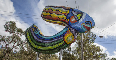 Nillumbik Shire Council
Public Art: Deborah HALPERN, 'Queen of the Shire'; Location: Cnr Kangaroo Ground-Warrandyte Rd & Research-Warrandyte Rd, North Warrandyte, 2015
Deborah Halpern was raised in Nth Warrandyte. Her connection to the area and the significant contribution that she and her family (founding members of Potters Cottage) have made to the artistic heritage and culture of the Shire is acknowledge with the commission of this piece. Deborah Halpern is a highly recognised and respected local artist with an acclaimed national reputation in the arts community. This work is a gateway piece, welcoming residents and visitors into the Shire from the southern end of the boundary. 'Queen of the Shire' reflects the creative spirit that flows endlessly in the Shire, inspired by the landscape. This work forms part of a series of sculptures that Halpern has created along the banks of the Yarra in Melbourne ('Angel' - Birrarung Marr and 'Ophelia' - Southgate). This sculpture is an excellent example of Halpern’s ouvere and 'tile construction' technique for which she is renowned. Materials: coloured glass tiles, fibreglass, aluminium, steel. A sweeping stylised (female) form covered in bright and colourful tiles held aloft by two steel poles. queen, sculpture, semi-abstract, stylised, glass, tiles, public art, halpern, ek prac 2015 -
Moorabbin Air Museum
Manual (Item) - NATO Advisory Group for Aerospace Researc;h & Development Reports - Unsteady Airloads in Seperated & Transonic Flow, AGARD Report No.108 Technical Evaluation of the Specialists' Meeting on Unsteady Airloads in Seperated & Transonic Flow
NATO -
Moorabbin Air Museum
Manual (Item) - Axial Flow Blower 1 PL 41-426 Mk3&4 Manual - RAAF
-
Moorabbin Air Museum
Manual (Item) - Pressure Controller Air Conditioning System Normalair Types 509240 509240FR and 514290 Demisting Blower Mass Flow Controller Intercooler Windscreen Wiper Motor, Pressure Controller Air Conditioning System Normalair Types 509240 509240FR
-
Moorabbin Air Museum
Manual (Item) - Societe de Fabrication D'Instruments de Mesure Technical Information Flight Recorders Timing Units Junction Boxes Electrical Receivers Altitude Measurements Differential Pressure Measurements Movement Detectors Acceleration and Vibration Indicators Air Flow Displacement Stree Temperature Optical, Societe de Fabrication D'Instruments de Mesure Technical Information
-
Moorabbin Air Museum
Booklet - Dual Snap Pressure, Temperature, Air Relay and Flow Switches, Custom Component Switches
-
Moorabbin Air Museum
Booklet (Item) - Basic overhaul instructions, Handbook of operation and service of PESCO hydraulic flow equalizer