Showing 1088 items matching "geological"
-
 Clunes Museum
Photograph, ca1861
When Richard Daintree rejoined the Victorian Geological Survey as a field surveyor in January 1859, he pioneered the use of photography in field-work. The glass plates attributed to him by the State Library of Victoria show four images of the mines in Clunes, Victoria, Australia in the 1860'sBlack and white reproduction of Port Phillip Colonial & Gold Mining Co., Clunes, Victoria, Australia in a light wood timber frameOn Reverse: Handwritten in pencil Port Phillip Co. 1860's Nettleton Photography glass plate Latrobe Libraryport phillip and colonial gold mining co., richard daintree -
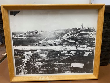
 Bendigo Historical Society Inc.
Document - BENDIGO STATE FORESTS - FORESTS NOTES
Forests Notes: Bendigo State forests newsletter published May 2006 by the State of Victoria, Department of sustainability and Environment. Getting there - indigenous culture - Bendigo's golden past - Geology and geomorphology - Discover nature treasures - Bendigo State forests - Activities to enjoy in State forests. Map of Bendigo State forests.government, state, department of sustainability -
 Bendigo Historical Society Inc.
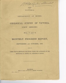
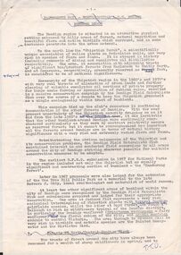
Document - MCCOLL, RANKIN AND STANISTREET COLLECTION: GEOLOGICAL SURVEY OF VICTORIA 1899, 1899
Booklet: 1899 Victoria Department of Mines Geological survey of Victoria (new series Nos. 6 &7. Monthly progress report, September, October issued by James Travis secretary for mines, under the Authority of the Hon. H. Foster M.P. Minister of Mines. McColl Rankin & Stanistreet, 1899 Victoria.MCCOLL RANKIN & STANISTREETorganization, business, industrial - mining, mccoll rankin & stanistreet -
 Bendigo Historical Society Inc.
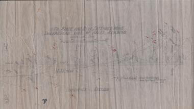
Map - STRUGNELL COLLECTION: HUSTLER'S LINE OF REEFS, September 1913
Map, Hustler's Line of Reefs, Hustler's Reef & Hustler's Reef No.1 Mines Plan.Plate No. XV1.(16) Sheet 2 .Bulletin No 33 Signed H.A.Whitelaw.Underground Survey Office, Bendigo, September,1913. Included is the emblem of the Geological Survey of Victoria. Drawing shows a plan view of reefs and shaft locations .Underground Survey Office, Bendigomap, bendigo, hustler's reef & hustler's reef 1 -
 Bendigo Historical Society Inc.
Document - PETER ELLIS COLLECTION: NOTES MENTIONING WHIPSTICK REGION
Four pages of typed notes mentioning the Whipstick Region, Mandurang Forest, Jackass Flat, Diamond Hill Area, One Tree Hill, and the Coliban/Sandhurst Water Supply Reserve. Mentioned are the Birds, Mammals, Geology, Flora, Ground Flora, Orchids,Lilies, Mistletoe, Ferns and Grasses of some of the areas.bendigo, parks and gardens, public reserves, peter ellis collection, north/central l.c.c. region bendigo block, bendigo field naturalists club, shipstick scrub, mandurang forest, one tree hill public park, redvers j eddy, coliban/sandhurst water supply reserve -
 Bendigo Historical Society Inc.
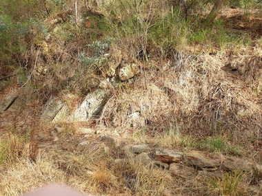
Document - MINING REPORTS - DEBORAH MINE - QUARRY HILL
Handwritten notes from a report by J. J. Caldwell, District Geologist. Ref. M. & Geological, July 1938. Page 29. Depth of Shaft 30 - 9 - 1937 - including well was 1025 feet as at 3 - 10 - 1932. Water was then making 500 gallons per hour. Baled with tanks.document, gold, mining reports, deborah mine quarry hill, m & geological, j j caldwell -
 Bendigo Historical Society Inc.
Map - UNITED HUSTLER'S & REDAN MINE - TRANSVERSE SECTIONS N & S OF SHAFT UNITED HUSTLER'S & REDAN MINE
Transverse Sections N & S of Shaft United Hustler's & Redan Mine on the Hustler's Line of Reef Bulletin No 33, Plate No XXX. Map shows some of the stone encountered on the levels and depth. Geological Survey of Victoria emblem and signed by H A Whitdan, Underground Survey Office Bendigo, September 1913.mining, parish map, united hustler's & redan mine, transverse sections n & s of shaft united hustler's & redan mine, hustler's line of reef -
 Ringwood and District Historical Society
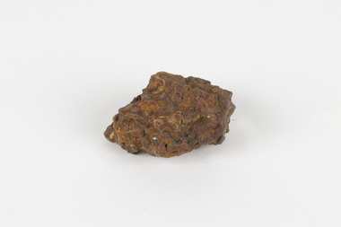
Piece of Rock, Collected by J. Lundy-Clarke, Lump of Black Rock - Sample of Metamorphic Rock from Hubbard Park, Ringwood 1979, Found 1979
Sample of metamorphic rock encountered by M.M.B.W. gang of tunnellers boring for a sewer drain through a geological fault-dyke along the southern boundary of Hubbard Park. The hole for 900 feet of 12.5 inch pipe took 6 months to bore from Oct-1979 to May-1980.Lump of black rock. +Additional Keywords: Lundy-Clarke, J. -
 Warrnambool and District Historical Society Inc.
Booklet - Booklet: Settlement of the Western District, Collett, Bain and Gaspar, Printers, Settlement of the Western District From Prehistoric Times to the Present, 1985
This booklet documents a public lecture series held in Warrnambool 3rd November 1984.This is a soft-cover book of 133 pages on the settlement of the Western District from prehistoric times to the present. It has a blue paper front cover and a grey paper back cover. The front cover is covered with a clear plastic sheet and the binding is plastic. The cover has an image of a sketch of the Warrnambool beach showing the lighthouse complex on Middle Island and the lighthouse on the beach (established 1860). There are a Contents page, a Foreword, a List of Plates and seven articles on different aspects of the Western District history by different authors. There are black and white photographs and illustrations. One page (p.17) has been annotated by Les O’Callaghan.This booklet documents a public lecture series held in Warrnambool 3rd November 1984.western victorian history, edmund gill, peter ronald, john sherwood, jan critchett, tony dingle, miles lewis, kevin o’toole, warrnambool, history -
Federation University Historical Collection
Booklet, Ballarat School of Mines Student's Magazine, September 1899, 1899
Table of contents: Editorial, News and Notes, Summaries and notes from the mining journals, Some recent steam plants at Bendigo, Professor T. S. hart. Students' Association, Notes on Victorian geology, Centrifugal pumps, A new chum's experience, Original poetry, Correspondence, Editorial notices.Pale green booklet of 12 pagesballarat school of mines, students' magazine, w. huey steele, w. lamb, j. m. bickett, james bickett, alex frazer, j. w. sutherland, a. w. g. mcpherson, w. a. gosman, w. waite, a. selwyn brown, a. babington, c. w. mirill, ottokar hofmann, professor g. j. dawbarn, professor t. s. hart, thomas hart, a. e. c. kerr -
Federation University Historical Collection
Book - Exercise book, The Metallurgy of Gold and Ore Dressing, 1908
William Baragwanath studied at the Ballarat School of Mines, obtained a Geology certificate in 1911. He was born on 01 august 1878 at Ballarat. He joined the Victorian Department of Mines in 1897 and was Chief Mining Surveyor from 1924 to 1943. Baragwanath died at Prahran on 20 Septemeber 1966.Black covered exercise book containing handwritten notes by William Baragwanath on metallurgy of gold & orr dressing Headings include: Orr dressing Battery practice Physical properties Copper Gold Assaying ballarat school of mines, mining, william baragwanath, gold, copper -
Federation University Historical Collection
Exercise Book, William Baragwanath, William Baragwanath's Exercise Book, 1898, 1898
William Baragwanath studied at the Ballarat School of Mines, obtained a Geology certificate in 1911. He was born on 01 August 1878 at Ballarat. He joined the Victorian Department of Mines in 1897 and was Chief Mining Surveyor from 1924 to 1943. Baragwanath died at Prahran on 20 Septemeber 1966.Marbled blue card covered exercise book with yellow tape spine containing handwritten notes by William Baragwanath on dividing land problems, earthworks, refraction, etc; Headings include: Tom Joe Smith ballarat school of mines, earthworks, land problems, refraction, william baragwanath, -
 Ballarat Heritage Services
Photograph - Photograph - Colour, Anticline in the Hepburn Springs Reserve, 2019, 22/04/2019
Anticlines are folded rock formations that have an upwards convex shape. Anticlines can exist as a single fold or as a series of adjacent folds of alternating synclines and anticlines. The Hepburn Springs anticline is geologically associated with the west dipping fissures cutting across sandstone strata of the Hepburn Spring anticline.Colour photograph of an anticline at Hepburn Mineral Springs Reserve, in close proximity to the Sulphur Spring. hepburn springs, anticline, geology, hepburn mineral springs reserve, hepburn anticline, hepburn geology -
 Federation University Historical Collection
Book, Hydraulic and Placer Mining, 1898, 1905
Blue/black hard covered book of 234 pages including index and photographic reproductions. Contents include Uses of Water in Mining; Geology of Placer Deposits; Gold Recovery; Flumes, ditches, dams, pipes; Giants, valaves, gates, weirs, miner's inch, pressure box, dams; gravel elvators; exploiting. mining, hydraulics, water, dredge, dredging, gold mining -
 Bendigo Historical Society Inc.
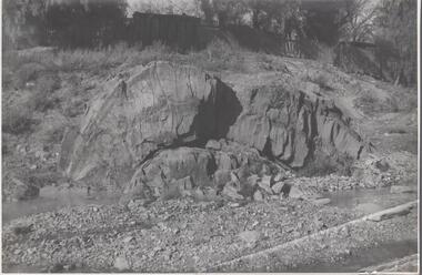
Map - RED WHITE & BLUE EXTENDED - PLAN OF RED WHITE AND BLUE EXTENDED MINE TRANSVERSE SECTION
Transverse section of the Red White & Blue Extended Mine on the Sheepshead Line of Reef showing shafts, depths and geological features. Drawn on tracing film in pencil. Signed by J J Caldwell, District Field Geologist, Mines Department, Bendigo and dated 5/12/1940. Notes prepared by Albert Richardson.document, gold, red white & blue extended, red white & blue extended, plan of red white & blue extended mine transverse section, j j caldwell, mines dept bendigo -
Federation University Historical Collection
Booklet, Ballarat School of Mines Student's Magazine, March 1899, 1899
Table of contents: Editorial, News and Notes, History of the School of Mines, Notes on Victorian Geology, Sir William Crookes, Summaries and notes from the mining journals, Students' Association, Sports, The Bush Assayer, Solubility of gold-silver alloys in potassium cyanide, Correspondence, Editorial notices, Publication receivedPale green booklet of 12 pagest. s. hart, sir william crookes, c. woodman, henry watson, james stirling, c. a. mulholland, s. b. j. skertchly, george f. becker, arthur h. thorpe, arthur s. boucher, henry louis, alfred james, john plummer, louis coste, w. terrill, h. g. brickhill, f. j. andrews, adam morton, w. gosman, j. matson, h. schaw, j. h. pratt, henry watson, william mcneil, ballarat school of mines, students' magazine -
 Bendigo Historical Society Inc.
Photograph - Napoleon Anticline, 1935
In structural geology, an anticline is a type of fold that is an arch-like shape and has its oldest beds at its core, whereas a syncline is the inverse of an anticline. A typical anticline is convex up in which the hinge or crest is the location where the curvature is greatest, and the limbs are the sides of the fold that dip away from the hinge.Significant to mining history of Bendigo.Black and white photograph: rock formation, anticline with an archlike shape in centre of image. Written in pencil on back of photograph : 'Napoleon anticline Golden Square'.napoleon gold mine, anticline -
 Federation University Historical Collection
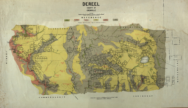
Map, Dereel, County of Grenville, 1890, 1890
Dereel is in western Victoria.Geological map of Dereel in the County of Grenville featuing six colours (predominantly grey and yellow). WGS 84 Centroid Lat: 37 degrees 48 feet 50 inches S Long:143 degrees 42 feet 10 inches S N-S: 6.4 km E-W: 15.2 km dereel, ferdinand krause, crown lands department, plan -
 Bendigo Historical Society Inc.
Map - STRUGNELL COLLECTION: HUSTLER'S LINE OF REEFS K.K.MINE, September 1913
Map, Hustler's Line of Reefs, K.K.Mine,Transverse section.Plate No.XXX11(32).Geological Survey of Victoria.Bulletin 33.Signed H.A.Whitelaw. Drawing shows the vertical shaft descending to over 1932 feet and appears to show samples of connecting horizontal shafts with their respective mineral contents and dotted lines appear to show connecting reefs .Underground Survey Office, Bendigo,map, bendigo, k.k.mine -
 Bendigo Historical Society Inc.
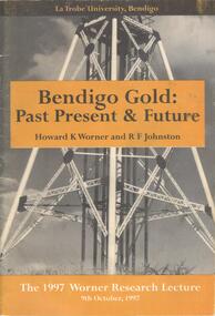
Document - BOOKLET: BENDIGO GOLD: PAST PRESENT & FUTURE - THE 1997 WORNER RESEARCH LECTURE, 1997
BHS CollectionSoftcover booklet produced for the 1997 Worner Research Lecture 9 October 1997. Cover contains black and white photograph of a poppet head, with gold coloured inserts bearing the title, authors and date. 29 pages with the contents of the lecture together with illustrations and photographs. Lecture covered the history and geology and the refractory gold ores.Published by Lat Trobe University Authors Howard K Worner and R F Johnston.bendigo, gold mining -
 Bendigo Historical Society Inc.
Map - HUSTLER'S REEF & HUSTLER'S REEF NO 1 MINES - PLAN OF THE HUSTLER'S REEF & HUSTLER'S REEF NO 1 MINES
Plan of the Hustler's Reef & Hustler's Reef No 1 Mines on the Hustler's Line of Reefs Bulletin No 33, Plate No XVII. Two drawings with different levels on each for clarity. Shows depth and some geographical features. Geological Survey of Victoria emblem. Signed by H A Whitelaw Underground Survey Office Bendigo, September 1913. mining, parish map, hustler's reef & hustler's reef no 1 mines, hustler's line of reefs, geological survey of victoria, underground survey office bendigo, h a whitelaw -
 Bendigo Historical Society Inc.
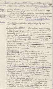
Document - DEBORAH MINE - DEBORAH MINE MACHINERY & EQUIPMENT
Handwritten notes on machinery and equipment at the Deborah Mine. Reference: Mining & Geological Journal July 1938, pages 28 & 29. Items mentioned include: Poppet Legs, winding engines, boiler, suction gas plant, electricity, battery and surface plant. J. J. Caldwell name on the paper. Also, a typewritten copymine, gold, deborah mine, deborah mine machinery & equipment -
 The Beechworth Burke Museum
Geological specimen - Slice Dendrites on Sandstone, Unknown
Dendrites are deposits of black minerals, typically manganese oxides that precipitated from water seeping through fractures in fine-grain rocks like a sandstone or limestone. Dendrites are much less regular than plant fossils and lacks vein structures. The manganese cryztallizes through the process called 'supercooling'. Some samples of dendrites occur in volcanic rocks in the Lilydale district, east of Melbourne. Sandstones are made of tiny sand grains that may have been deposited in the sea and later formed together. Most sandstones are made of quartz which are chemically-resistant minerals. This particular specimen was donated by Alfred Selwyn in 1868 as part of the Geological Survey of Victoria. It is connected to the original 1875 catalogue on Geological Specimen with number 189 'Quartz Crystals_Quartz Crystals (two are polished)'Dendrites on sandstones This specimen is an important contribution to the geological history of Victoria, as well as its links to the 1868 Geological Survey of Victoria. This specimen is part of larger collection of significant geological specimens in the Burke Museum that was collected from around the world between 1868-1880. A large percentage of these specimens were collection as part of the Geological Survey of Victoria 1852-1974. The Geological Survey of Victoria was an organisation founded in response to the Victorian gold rush to explore the geological and mineral resources and to record a detailed map of the state. It was headed by British geologist, Alfred Richard Cecil Selwyn (1824-1902), who was responsible for issuing over 60 geological maps during his 17 years as director. These maps were all hand-drawn and coloured and became the benchmark for accuracy for geological mapping. Collecting geological specimens was an important part of mapping and understanding the scientific makeup of the earth. Many of these specimens were sent to research and collecting organisations across Australia, including the Burke Museum, to educate and encourage further study. A hand-sized slice of light brown sandstone with dendrites formed from crystallized manganese oxide.Existing label: Not sure what / 'Slica dondrites' / means. / Sample is sandstone and original label / identifies it as from / the Grampians near Stawell. / C. Willman / 15/4/21 Other label: [illegible] / stone [ illegible] / from Grampians Stawell / 1894 /geological specimen, geology, geology collection, burke museum, beechworth, dendrites, sandstones, quartz, lilydale district, geological survey of victoria, grampians, victoria rocks, minerals, rocks, manganese oxides, alfred selwyn -
 The Beechworth Burke Museum
Geological specimen - Feldspathic Sandstone
... geological ...Feldspathic arenites are sandstones that contain less than 90% quartz, and more feldspar than unstable lithic fragments, and minor accessory minerals.Feldspathic sandstones are commonly immature or sub-mature.These sandstones occur in association with cratonic or stable shelf settings. Feldspathic sandstones are derived from granitic-type, primary crystalline, rocks. If the sandstone is dominantly plagioclase, then it is igneous in origin Sandstone features prominently in public buildings throughout Victoria. Most of the sandstone used as dimension stone in the State came from three sources: the Heatherlie quarry in the Grampians (Silurian), the Bacchus Marsh area (Permian), and the Barrabool Hills near Geelong (Cretaceous).Sandstone features prominently in public buildings throughout Victoria, making this specimen special as it shows the materials used by Victorian building companies. Sandstone can also be crushed, crushed stone is used in the construction of roadways and road structures such as bridges, and in buildings, both commercial and residential. This specimen is part of a larger collection of geological and mineral specimens collected from around Australia (and some parts of the world) and donated to the Burke Museum between 1868-1880. A large percentage of these specimens were collected in Victoria as part of the Geological Survey of Victoria that begun in 1852 (in response to the Gold Rush) to study and map the geology of Victoria. Collecting geological specimens was an important part of mapping and understanding the scientific makeup of the earth. Many of these specimens were sent to research and collecting organisations across Australia, including the Burke Museum, to educate and encourage further study. A feldspar-rich sandstone, a sandstone intermediate in composition between an arkosic sandstone and a quartz sandstone, containing 10% to 25% feldspar and less than 20% matrix material of clay, sericite, and chlorite. Feldspathic arenite containing less than 90 percent of the composition of quartz. Feldspar is the main composition. Feldspathic arenite may contain fragments of unstable rock, and a little amount of other minerals such as mica and heavy minerals. Some feldspathic arenite have pink or red color because of the presence of potassium feldspar or iron oxide. There are also colored light gray to white. These sandstones are usually medium to coarse grained and can contain a high percentage of granules with angular until subangular roundness. The content of the matrix can appear as the rest up to more than 15 percent, and sorting of grains can present as moderate to poorly sorted. Feldspathic sandstones are generally immature in textural maturity. Feldspathic arenite can not be judged from the structure of the sediment. Bedding can emerge from the laminate parallel to the crossbed. Fossils may appear in the layer deposited on the sea. Feldspathic arenites usually appear on the craton or the continental shelf, which can be associated with conglomerate, quartz lithic arenite, carbonate rock, or evaporites. This sandstone may also appear on the succession of sedimentary basins deposited on an unstable or deep sea, and moving arc setting. According to Pettijohn (1963) Arkose make up about 15 percent of all sandstones. Some Arkose formed in situ when the granite and related rocks disintegrate and generate granular sediments. Most of the material feldspathic sandstones derived from primary crystalline granitic rocks, such as granite or metasomatic rocks containing abundant potassium feldspar. Mineral contained in sandstones is mostly a form of plagioclase feldspar derived from quartz diorite or volcanic rock. Feldspar contained on this sandstone comes from arid to cool climates when the chemical weathering process is reduced.sandstone, natural stone, feldspathic sandstone, burke museum, geology, geological, geological specimen -
 The Beechworth Burke Museum
Geological specimen - Laterite
... geological ...Laterite refers to both a rock and a soil type that is rich in clay, as well as Iron and Aluminium. It is created during a process that is called laterization, where high heat and seasonal heavy rainfall cause there to be wet and dry periods, which over time hardens the soil into rock. Because of this, most laterite is formed between tropics of Cancer and Capricorn. The iron oxide in laterite is what gives it it’s orange-red colouring. The largest religious complex in the world, Angkor Wat in Cambodia, is partially constructed of laterite, particularly its foundations, as laterite is porous and allows rainwater to drain. This specimen of laterite was collected from the Democratic Republic of Congo while it was colonised by Belgium in the 19th century. Laterite forms in many parts of the world, particularly between the tropics. It is used both for ore and as a building material, and comparing specimens from different parts of the world allows us to document the different compositions that this mineral can have when formed at different locations. This specimen is part of a larger collection of geological and mineral specimens collected from around Australia (and some parts of the world) and donated to the Burke Museum between 1868-1880. A large percentage of these specimens were collected in Victoria as part of the Geological Survey of Victoria that begun in 1852 (in response to the Gold Rush) to study and map the geology of Victoria. Collecting geological specimens was an important part of mapping and understanding the scientific makeup of the earth. Many of these specimens were sent to research and collecting organisations across Australia, including the Burke Museum, to educate and encourage further study.a palm-sized solid iron-aluminium oxide mineral specimen in shades of brown, orange and greyburke museum, beechworth, geological, geological specimen, laterite, laterite specimen, geology -
 Federation University Historical Collection
Plan, Parish of Lal-Lal County of Grant
... geological ...Printed colour map on paperlal lal, mt doran, lal lal racecourse, geology, geological, moorabool river, mount duran -
 The Beechworth Burke Museum
Geological specimen - Tourmaline (schorl), Unknown
... geological ...Tourmaline is a group of minerals belonging to the complex borosilicate mineral class. These minerals are known for their striking and varied colours, making them prized gemstones. Tourmaline crystals can come in various shades, including pink, green, blue, brown, black, and colourless. They are often transparent or translucent. Tourmaline's chemical composition is complex, but it typically includes elements such as aluminium, iron, magnesium, sodium, lithium, and potassium. The specific arrangement of these elements in the crystal lattice gives rise to the different colours and properties of tourmaline specimens. Tourmaline specimens from Beechworth, Victoria, Australia, are a notable part of the region's mineral heritage. These tourmalines are of interest to mineral collectors and enthusiasts. While the tourmaline found in Beechworth is not as well-known as some other tourmaline varieties, it has unique characteristics and a historical context associated with the gold mining areas in Beechworth.The significance of tourmaline in Beechworth, Victoria, Australia, lies in its unique geological and historical context, contributing to both scientific and cultural aspects. The tourmaline mined in Beechworth is a rare and unique variety of tourmaline that is primarily found in the historic gold mining areas surrounding Beechworth. Its occurrence is closely linked to the geological processes that shaped the region during the Gold Rush era. The discovery of tourmaline in Beechworth adds to the rich mineral heritage of the area, which was historically known for gold mining. The specimens serve as a tangible connection to the region's mining history and contribute to preserving its geological legacy. The presence of tourmaline in Beechworth showcases the mineralogical diversity of the area. Tourmaline is known for its wide range of colours and unique properties, making it a valuable subject of study for mineralogists and geologists. Tourmaline specimens from Beechworth have educational significance, providing opportunities for research and study. They offer insights into the geological processes and mineral formation in the region, contributing to a better understanding of Earth's geological history.A hand-sized solid mineral specimen in shades of brown, green, light grey and dark greyTOURMALINE (schorl) / (Silicate of boron and aluminum) burke museum, beechworth, indigo shire, geological, geological specimen, mineralogy, tourmaline -
 Bendigo Historical Society Inc.
Document - KANGAROO FLAT GOLD MINE COLLECTION: MEMO TO SANDNER FROM WILLMAN
Two page memo 17 January 1984, to R. Sandner, D. Cahill, R. Cameron, P.Vail and D. Andrew from C.E. William. Topics covered: Deborah lease project; Brunswick Mine Costerfield, E.L's 1397 and 1398; town planning permit application; historical research and geological assessment, dewatering programme.bendigo, gold mining, deborah lease project -
 Federation University Historical Collection
Book, Ballarat College of Advanced Education Annual Report, 1979, 1979
In 1980 the President was M.B. John. In 1980 the administration staff moved out of the lower level of the library and the space was converted for teaching use. Extensive alterations were made to the lower level of the mechanical/Civil Engineering wing for the housing of Applied Geology and Environmental Science. Car parking facilities were extended at Mt Helen.Orange soft covered book of 35 pages. Contents include: Courses, student numbers, Victorian School of Forestry, financial statement, Education Building (T Building) completed, Gillies Street Campus, Art building under construction, Great Hall (1870s Founders Hall) completion date expected to be mid 1980, Centenary Appeal, E.J. Barker Library, Computer Centre, bookshop . ballarat college of advanced education, bcae, mt helen, mount helen, library computer -
 Federation University Historical Collection
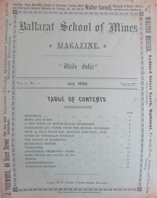
Magazine - Booklet, Ballarat School of Mines Student's Magazine, July 1899, 1899
Table of contents: Editorial, News and Notes, A few hints on histological technique, Summaries and notes from the mining journals, Professor A. Mica Smith B.Sc., Notes on Victorian geology, The origin of diamonds, Hydraulic mining, Volcanoes, Analytical chemistry notes, Some things we ought to do, Sports, Correspondence, Editorial notes.Pale green booklet of 10 pages. ballarat school of mines, students' magazine, g. e. saunder, w. wallace, j. booth, f. farnell, h. waller, a. h. freeman, w. e. hearman, professor dawbarn, e. gutheil, a. selwyn brown, h. watson, a. w. k. peirce, professor mica smith, w. bradford, henry watson, mr e. faribault, j. h. parsons, j. holmes pollock, t. s. hart, thomas hart, alfred mica smith, a. e. c. kerr, g. g. bonney, histological technique, diamonds, victorian geology, massey-harris bicycles, adelaide school of mines, ballarat school of mines colours, ballarat school of mines motto, ballarat school of mines badge, w.hirt, e. byron moore, britannia gold mine, visitors, j. bryant, premier mine coolgardie, last chance gold mine, g.e. saunder, ivanhoe mine kalgoorlie, black horse cyanide works, edgerton, hercules mine, mount reid, tasmania, f. parnell paul, zeehan school of mines, a.h. freeman, crown point gold mining co, w.e. hearman, parker's range, southern cross, w.a., trappean rocks, hydraulic mining, a.e.c. kerr, volcanoes, f.g. bonney, l.j. austine and co., downer and co, carter and werner