Showing 1669 items matching "junction"
-
 Melbourne Tram Museum
Photograph - Black & White Photograph/s, LWR, c1920
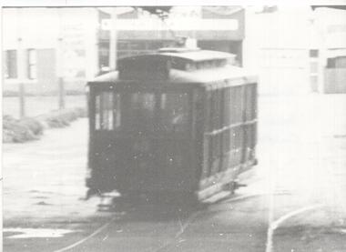
Copy photographs . Photograph, Black and White of MMTB tram F46 about to pass under the railway bridge at Caulfield. Photo is very poor copy. Has the Caulfield loop junction in the foreground.In ink on the rear: " Melbourne Probably F46, under railway bridge at Caulfield, About 1920." Has KSK number LWR5 and ADV322trams, tramways, f class, pmtt, bridges, caulfield, tram 46 -
 Melbourne Tram Museum
Photograph - Black and White photograph, 1967
Black and White photograph of W5 790, Route 56, West Coburg about to leave the junction at Flemington Road and run through Royal Park. The tram shelter and cross over are in the view.On rear in ink "Melbourne Vic (1967)"trams, tramways, w5 class, royal park, flemington road, route 56, shelters, tram 790 -
 Ballarat Tramway Museum
Photograph - Black & White Photograph/s, Dave Macartney, Early 1970's
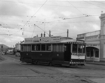
Yields information about the area known as Hospital corner or Hospital junction and the appearance of the trams prior to closure.Black and white photograph of SEC No. 28 turning from Sturt St into Drummond St. South, at Hospital Corner with Destination of Sebastopol. Tram has two SEC Roof advertisements - "Electricity Best for Cooking" and "Everything's under control in my all electric kitchen". Has also Rimmington Bros. shop in the background and other shops on the south side of Sturt. St. Colour photocopy, laminated, of this photograph on display 5/2000 at 02-02-06 1413.1 - as for above, but slightly wider view both sides. Shows the Town Hall and part of the hotel."DJM" on back of print in pencil.trams, tramways, hospital corner, sturt st, junction, tram 28 -
 Malmsbury Historical Society
Photograph (Item), The Mansions Malmsbury + 2 M/Print, Malmsbury ca1970
People - "Young, Betty" Buildings - "The Mansions,Junction Holtel" -
 Kiewa Valley Historical Society
Postcard - Junction Dam - Circa 1950, Circa 1950
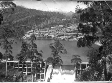
This postcard was produced in the 1950's for the tourist trade in the Kiewa Valley and Alpine region. It encompasses the period when the State of Victoria was pressured by the ever increasing demand by industry and its population for electricity supplies. Hydro electricity was seen as an untapped natural resource to quench this demand. The Victorian Alps and the rivers flowing into its valleys was ideal for the construction of the Kiewa Hydro Electricity Scheme. The late 1940's saw the development of this scheme and the changing of sections of alpine landscape is covered by this and other postcards/pictures (tourists, construction workers, and established rural populations). This period in time was before the established wildlife and forest/nature groups became political activist who changed legislative acts to protect the environment.This rural region (Kiewa Valley/alpine plains) was at most only significant to a smaller group of winter sports, summer hikers/horse riders and rural farmers/graziers. The numbers of tourists and the increase in the local resident population was boosted by the construction of the Hydro Electricity Scheme. This influx to the regional population resulted in a corresponding diversity in services and brought about an environment that responded to a growing level of tourists and thereby permitting this industry to grow more rapidly than it would have naturally. This postcard details an attraction to the "cleaner" method of providing electricity. This postcard was purchased in 1950 by a surveyor at Landford's Gap.This black and white photograph on a Valentine's postcard is from a V2 Argus photograph. It is on a 200g/m paper density one side gloss only/. See 0480 (A) -(L) for other photos of similar postcards."JUNCTION DAM & SPILLWAY, LAKE GUY, BOGONG, KIEWA HYDRO-ELECTRIC PROJECT" "V5" on the flip side" VALENTINE'S POST CARD " "A GENUINE PHOTOGRAPH"kiewa valley tourism, victorian alps, alternate energy supplies, alpine population growth, junction dam, secv -
 Kiewa Valley Historical Society
Set of 6 framed photographs - Kiewa Hydro Electric Scheme
Official photo of KHES constructed by SECVOfficial photo of KHES in the Kiewa Valley1. No. 1 Pipeline - from Anchor 1 to Anchor 5. August 1955 2. Junction Dam - General View from Downstream - May 1943 3. No. 3 Power Station - Clover Flat Camp - February 1951 4. Clover Dam - October 1954 5. View from Downstream of Junction Dam - July 1943 6. Upper Kiewa Valley Road 3 to 4 Mile - Mt Arthur in Background - July 1954 khes, secv -
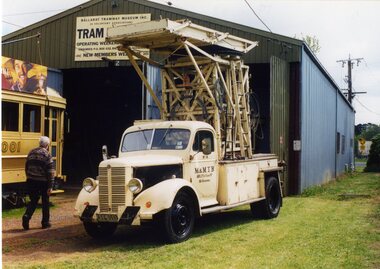
 Ballarat Tramway Museum
Photograph - Black & White Photograph/s - set of 4, Richard Gilbert, Sept. 1975
Series of four Black and white photographs of tram 26 being operated following maintenance in Wendouree Parade. The tramcar record sheets note that the car was lifted 15-3-1975 and lowered 27-7-1975 and tested on the same day. Seems to have re-entered service on 28/9/1975. .1 - At Gardens Loop. .2 - At depot Junction .3 - At St Aidans Drive with Andrew Hall standing at the rear of the tram. .4 - at depot Junction. trams, tramways, btps, gardens loop, maintenance, wendouree parade, depot junction, st aidans drive, tram 26 -
 Ballarat Tramway Museum
Photograph - Colour Photograph/s - set of 6, Carolyn Dean, 19/10/2003 12:00:00 AM
Set of six photographs taken by Carolyn Dean of the BTM services - AGM 2003 on 19.10.2003. 2600.1 - No. 28 arriving at Depot Junction. 2600.2 - No. 28 leaving Depot Junction with No. 27 waiting to cross Wendouree Parade 2660.3 - No. 27 crossing Wendouree Parade on Members Special 2600.4 - No. 27 at Carlton St. terminus 2660.5 - Nos. 661, 27 and 45 on Depot Fan 2660.4 - Tower Truck outside Depot on No. 1 Road, with No. 45 in background.On rear of each print in blue biro "19.10.03" / "Photo by Carolyn Dean".btm, depot, wendouree parade, tram 28, tram 27, tram 45, tram 661 -
 Ballarat Tramway Museum
Ephemera - Membership Card/s, Ballarat Tramway Museum (BTM), 2015
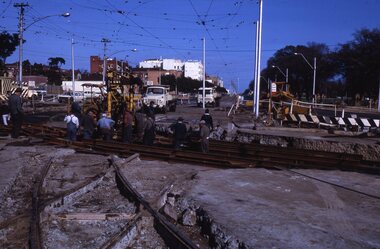
Colour photograph printed onto white card as a BTM Membership card for 2015 - 2016. Photo of trams 27 and 671 at depot junction Jan. 2015 following the reconstruction of Wendouree Parade. Has the words "Ballarat Tramway Museum" in green block printing on the upper edge of the card. On rear along bottom edge, has words "Trams 27 & 671 at Depot Junction 2015. Photo P. Winspur" Two copies held. No label on rear.trams, tramways, membership cards, depot junction, btm, wendouree parade, road works -
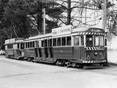 Ballarat Tramway Museum
Photograph - Black & White Photograph/s, Leon Marshall-Wood, Aug. 1964
Yields information about the Ballarat's tramcars in the mid 1960's before the white strip was extended under the dash canopy lighting.Black and white photograph of Ballarat No. 36 and a single truck car at the SEC's Depot Junction. No. 36 has the destination of Mt Pleasant, and a "Cook with Electricity" roof advertisement. A single truck stands behind.On the Rear in ink "Wendouree Pde, Ballarat 8/64" and a "L. Marshall-Wood Photograph" stamp on the rear.tramways, trams, wendouree parade, secv, depot junction, tram 36 -
 Ballarat Tramway Museum
Slide - 27 mm sq slide/s, Andrew Howlett, Tram 28 in Wendouree Parade, Mar. 1969
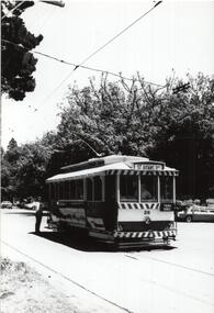
Yields information about the services in Wendouree Parade near the future BTPS/BTM depot junction.Colour slide, Kodak white cardboard mount, developed March 1969, of No. 28 (Mt Pleasant) in Wendouree Parade approaching what is now the BTM Depot Junction. Has the toilet block in the background.ballarat, tramways, trams, wendouree parade, depot junction, tram 28 -
 Kew Historical Society Inc
Photograph, Stewart West, High Street, Kew, 2001, 2001
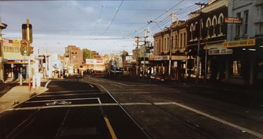
High Street, Kew. View west towards Kew Junction. One of a pair of photographs prepared by Stuart West comparing the vista in c. 1890 and 2001. This photograph dates from the later date.Nilhigh street (kew) -
 Kew Historical Society Inc
Photograph - Street Works, Studley Park Road, March 1934
Studley Park Road, like most streets in Kew, was originally a dirt road. Street works during the Great Depression included bituminising major roads in the district. This photograph of Council works originated in the City of Kew Engineers Department as a record of works undertaken. It was given to the collection by a Mrs Fisher in 1998.Well provenanced photograph of Council-funded public works in Kew during the Great Depression. Original sepia monochrome positive of Council workers standing on and beside a dray in Studley Park Road, Kew while resurfacing of the street was taking place. The Kew Junction is just visible behind the men.Typed reverse: "B4 / Kew C.C. / Spreading premixed material on Studley Park Road with drag spreader, view from rear of machine, March 1934"roadworks -- kew (vic.), street works -- kew (vic.), public works kew (vic.), studley park road -- kew (vic.), city of kew -- engineers department, city of kew -- public works -- great depression -- 1930s -
 Bendigo Historical Society Inc.
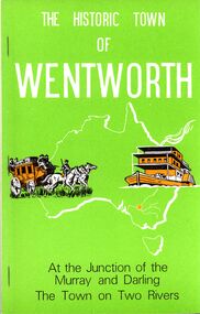
Book - STRAUCH COLLECTION: THE HISTORIC TOWN OF WENTWORTH
BHS CollectionThe Historic Town Of Wentworth, at the junction of the Murray and Darling, the town on two rivers.History of Wentworth Sunraysia's oldest town seventh edition December 1984, soft cover 88 pages with black and white photographs.australia, history, wentworth, australia-history-nsw-wentworth -
 Eltham District Historical Society Inc
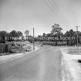
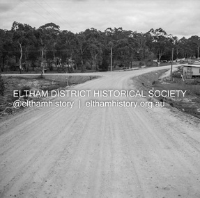
Negative - Photograph, J.A. McDonald, Heidelberg-Kinglake Road, Mar. 1960
Completed junction Looking north March 1960 Job 56M411Record of various Shire of Eltham infrastructure works undertaken during the period of 1952-1962 involving bridge and road reconstruction projects, sometimes with Eltham Shire Council Project Reference numbers quoted. It was during this period that a number of significant improvements were made to roads and new bridges constructed within the shire that remain in place as of present day (2022). In many situations, the photos provide a tangible visible record of infrastructure that existed throughout the early days of the Shire. The album was put together by or under the direction of the Shire Engineer, J.A. McDonald.infrastructure, 1960-03, bridge construction, cherry tree road, heidelberg-kinglake road, road construction, shire of eltham -
 Parks Victoria - Wilsons Promontory Lightstation
Part, electrical
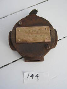
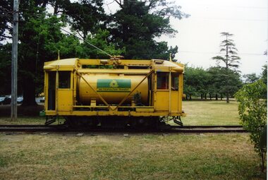
Used as a junction box for metal conduit in RAAF power house.This technical item has second level significance because their use is likely to be directly linked to WWII communications activity at the lightstation:Round metal piece with protrusions and with "12 VOLT / CHARGING" stamped on a metal plate on the front."12 VOLT / CHARGING" -
Glen Eira Historical Society
Article - Grand Union Tramway Junction, Balaclava Road and Hawthorn Road
This file contains three items. 1. A three-page Caulfield Conservation Study of the Balaclava Road/Hawthorn Road Tramway Crossing, undertake by Andrew Ward and dated September 1994. Study includes a brief history of the junction and a statement of significance. Study also includes Four black and white photographs of the junction and of architectural details of the tram tracks. 2. A letter from the Conservation Manager of the National Trust of Australia (Victoria) to the manager of the Planning Section for the City of Glen Eira, dated 15/06/2001 and attached to a six-page Classification Report. The letter informs of the Classification of the Grand Union Junction at the intersection of Balaclava and Hawthorn Road by the national trust, signed by Conservation Manager Ian Pausacker. Classification Report includes details such as the date of construction, a statement of significance, history of the junction, physical description of the junction and the condition of the junction at the time of writing. Report also includes a map of the Melbourne Tram Network drafted by Keith Kings and dated 01/005/1956, with illustration of the layout of fifteen tram depots, and updated aerial illustration of the Grand Union Junction, and a further map of Melbourne Tramways developed by North Melbourne Electric Tramways and Lighting Co. and Prahran and Malvern Tramways Trust, drafted by Keith Kings and dated January 1914 with illustrations of three tram depots. 3. Two articles from the Caulfield Leader written by Aaron Langmaid and dated 13/02/2007 and the Melbourne Bayside Weekly dated 21/02/2007 written by Joanne Sim, both concerning the Grand Union Junction. The article from the Caulfield Leader includes a picture of Executive Officer of the council of Tramway Museum of Australia Craig Tooke in front of the intersection. The article from the Bayside Weekly includes a picture of a tram passing through the junction and a brief history of the junction and tram network in Caulfield. The article also refers to twp local tram shelters at the intersection of Dandenong Road and Alma Road and also Orrong Road and Balaclava Road.caulfield, caulfield conservation, study, balaclava road, hawthorn road, grand union junction, ward andrew, tramway crossings, transport, acland street, caulfield racecourse, tram tracks, race events, event, tram routes, thorough fares, melbourne and metropolitan tramways board, prahran and malvern tramway trust, prahran and malvern district tramways, caulfield electric tramways, caulfield city council, architectural detail, city of glen eira, balaclava road and hawthorn road intersection, balaclava road and hawthorn road junction, dandenong road, glenhuntly road, four-way tram junctions, access covers darling road, cast metal access covers, hadfields patent, caulfield park, tram systems, tram networks, heritage, tramway heritage, kings keith, tram depots, glenhuntly depot, maps, glen eira, melbourne electric tramways, north melbourne electric tramways and lighting co., prahran and malvern tramways trust, caulfield leader, bayside weekly, tooke craig, tourist attractions, grand union tramways junction, caulfield junction, cable car tramways, tram shelters, building, sheds, alma road, orrong road, caulfield electric line, balaclava junction, elsternwick railway station, caulfield station, caulfield station loop, tram services, transport establishments, thoroughfares, buildings, structures, establishments, parts of buildings or structures, documents, commercial industry, sites, historic sites, melbourne bayside weekly -
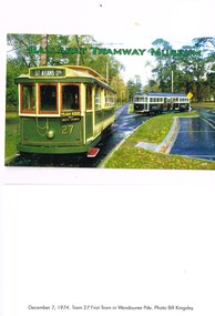
 Melbourne Tram Museum
Slide - Set of 2, Keith Kings, 5/05/1968 12:00:00 AM
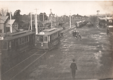
Set of two 35mm Kodak white cardboard colour slide by Keith Kings of 5/5/1968 .1 - construction of new curves from Fitzroy St and High St into St Kilda Road. Shows the old junction trackwork and road height differences. Note the temporary tram stop. .2 - ditto, shows the trackwork for High St behind the hotel and the Junction Hotel with a large Dunlop sign and Rothmans cigarette advert. See Keith's slide notes.Keith Kings stamp and number "23-27 and 23-28", with details of exposure. .1 - St Kilda Jtn by pass work. installing new turnout for Fitzroy St. In new track, New level is lower. Old curves replaced after a day's work to all normal service to resume during weekdays. .2 - St Kilda Bypass work. Installing new turnout for Fitzroy St. In new track looking south. Old Jtn out of photo to the left. New concrete track ready at rear on right. Hotel (which will remain in the middle of everything!!)trams, tramways, st kilda junction, fitzroy st, st kilda rd, trackwork, high st -
 Melbourne Tram Museum
Slide, Melbourne & Metropolitan Tramways Board (MMTB), c1926
35mm colour slide TMSV copy slide of trackwork at St Kilda Junction, possibly soon after a change over to the new track in St Kilda Road. Has W 366 (St Kilda Beach) on the temporary or new track pending the construction of a road surface and the link to Wellington St. Photo may be from a photo held in the Public Records Office series. On the corner of Punt and St Kilda Road is s building advertising Schweppes Junction Motor service station."MP 30" in pencil on the side.trams, tramways, st kilda junction, trackwork, new tramways, w class, road works, tram 366 -
 Ballarat Tramway Museum
Photograph - Corner Ryrie and Garden Streets - Eastern Park, 9/1923
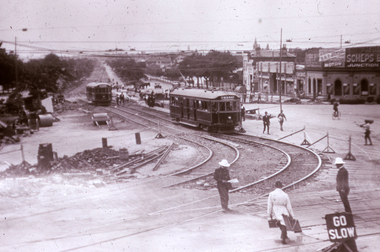
The photograph shows at least 6 six trams at Eastern Park after a football match and the Garden St junction for the East line. Tram No. 5 with a destination of West Geelong is leaving the junction. Another tram is arriving with at least four parked on the Eastern Park line. Yields information about the use of trams after a football match in Geelong.Black and white photograph with some details on rear.In ink "Cr Ryrie & Garden Sts, this type of tramcar also in service 1947" and hand date stamp of "15 Sep 1923"tramways, trams, geelong, ryrie st, garden st, eastern park, football, tram 5 -
 Kiewa Valley Historical Society
Set of 3 black and white photographs of Lake Guy, Bogong Village and single men's quarters, 1943/44
Construction of Bogong Village was commenced in 1940 and was the Field Headquarters for the early part of the construction of the Kiewa Hydro Electric Scheme. In all, a total of 36 houses, medical centre, police station, trading store and primary school were built. As well, there was a hostel for staff personnel and prefabricated units, each 10 feet x 8 feet, with separate dining and recreational facilities for the worker's. This camp was closed in 1962.These photos show the type of accommodation, available in this period, as well as the benched layout of the village. The damage of the 1939 bushfires is still evident.1. Black and white photo of Junction Dam Wall, Lake Guy and Bogong Village. 2.Black and white photo of single men's quarters at Bogong Village. 3.Lake Guy and Bogong Village.1.Back of photo, Left upper corner - K1334 Upper Right corner - mu (very faint) 6-10-43 2.Back of photo, Left upper corner - K1399 Upper right corner - 14 m 1-2-44 3. Back of photo, left upper corner -K1738 Upper right corner - 145 a mus 5-12-44 bogong village, lake guy, secv -
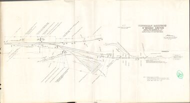 Bendigo Historical Society Inc.
Document - BADHAM COLLECTION: VICTORIAN RAILWAYS MAP - NTH BENDIGO JUNCTION SIGNALLING DIAGRAM NO 4'80
Victorian railways map: Nth Bendigo junction signalling diagram no 480 showing signal and interlocking arrangements. Large paper map, A F chief electrical engineer 9.1.1980. Black ink diagram and writing.document, memo, railway, nth bendigo junction signalling diagram no 4'80 -
 Whitehorse Historical Society Inc.
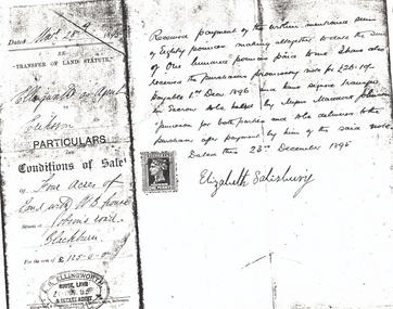
Document, Jobson's Road, 28/12/1895
Part of contract of sale between Elizabeth Salisbury (Vendor) and Eriksson (purchaser) of four acres of land with weatherboard house at Jobson's RoadPart of contract of sale between Elizabeth Salisbury (Vendor) and Eriksson (purchaser) of four acres of land with weatherboard house at Jobson's Road, Blackburn (now Junction Road, Blackburn North), 28 December 1895.Part of contract of sale between Elizabeth Salisbury (Vendor) and Eriksson (purchaser) of four acres of land with weatherboard house at Jobson's Roaderiksson, salisbury, elizabeth, jobson's road, blackburn, junction road, blackburn north, land sales -
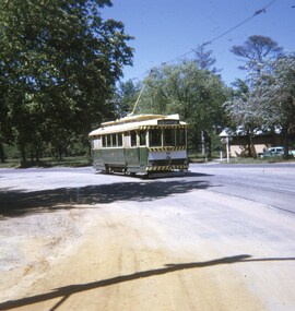
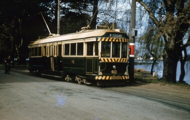 Ballarat Tramway Museum
Slide - 35mm slide/s, Keith Caldwell, 14/09/1962 12:00:00 AM
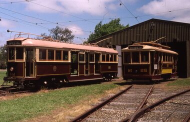
Yields information about trams 40 at the Depot Junction.Kodak colour duplicate slide, white cardboard mount, photo by Keith Caldwell during on 14.9.1962 of: Trams 40 reversing at Depot Junction. Tram has the destination of Mt Pleasant and Lake Wendouree is in the background.In ink "Ballarat 40 14.9.62".tramways, trams, depot junction, wendouree parade, lake wendouree, tram 40 -
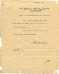 Ballarat Tramway Museum
Document - Instruction, State Electricity Commission of Victoria (SECV), "Notice for Motormen/Conductors and Conductors", 30/5/19561
Yields information about the type of instruction issued to crews and demonstrates important safety issues in regard to the position of point blades at junctions.Typed notice on Quarto paper, titled "Notice for Motormen/Conductors and Conductors" about the need to reset the depot junction points for the through road. Dated 30/5/1951 and signed by the Branch Tramway Superintendent.trams, tramways, depot, safety, points, wendouree parade, instructions -
 Ballarat Tramway Museum
Photograph - Colour Photograph/s - set of 10, Warren Doubleday, 20/01/2002 12:00:00 AM
Set of 10 colour photographs / prints of Scrubber 8 in Wendouree Parade and depot track on 20/1/2002, working and testing the sprinkler bar on No. 1 end of the tram. Photos by Warren Doubleday. On Kodak paper. 1962.1 - Scrubber 8 on access track .2 - At depot junction, with 45 behind, ice cream van alongside. .3 - With sprinkler bar operating .4 - ditto .5 - ditto .6 - showing the very end of the sprinkler bar under No. 1 end, at the back of the flusher hood. .7 - showing the valve and water line for the sprinkler bar. .8 - ditto .9 - showing the watered roadway coming down into depot junction from Carlton St. .10 - Simon Green cleaning depot junction points. (Photo used in Jan. 2002 Fares Please!) On .10 only in blue ink, date "20/1/02" scrubber tram, btm, sprinkler bar, depot junction, tram 8 -
 Ballarat Tramway Museum
Slide - Set of 10 - COTMA 2000 Visit to BTM, David Verrier, 22-11-2000
Set of nine slides taken during the 2000 COTMA Conference visit to the Ballarat Tramway Museum depot on 22-11-2022 1 - not used 2 - 661 and 26 on depot fan 3 - Trams 26 and 38 on depot fan 4 - Tram 661 in Wendouree Parade and 40 on access track. 5 - Tram 671 in Wendouree Parade near depot junction. 6 - Tram 671 in Wendouree Parade near depot junction. 7 - Tram 661 in Wendouree Parade near depot junction. 8 - Trams 661 and 671 at depot junction 9 - Tram 661 running into the depot access track with red flag displayed 10 - Tram 18 off the roadDemonstrates part of the BTM fleet and operations during the COTMA visit,Set of nine Kodak colour slides - white plastic mountEach slide has details written on it.ballarat, specials, cotma, btm depot, tram 26, tram 671, tram 661, wendouree parade, tram 38, tram 40 -
 Eltham District Historical Society Inc
Negative - Photograph, J.A. McDonald, Heidelberg-Kinglake Road, Hurstbridge, Sep. 1959
During reconstruction of approaches looking towards Cherrytree Road junction September 1959Record of various Shire of Eltham infrastructure works undertaken during the period of 1952-1962 involving bridge and road reconstruction projects, sometimes with Eltham Shire Council Project Reference numbers quoted. It was during this period that a number of significant improvements were made to roads and new bridges constructed within the shire that remain in place as of present day (2022). In many situations, the photos provide a tangible visible record of infrastructure that existed throughout the early days of the Shire. The album was put together by or under the direction of the Shire Engineer, J.A. McDonald.infrastructure, shire of eltham, bridge construction, cherry tree road, hurstbridge, road construction -
 Kew Historical Society Inc
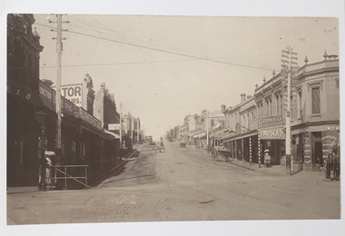
Photograph, High Street, Kew, 1891
Early photograph of High Street, Kew, looking east from Kew Junction.High Street, Kew, circa 1891.high street, kew, kew junction, streets -- kew (vic) -
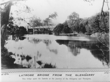 Lakes Entrance Historical Society
Photograph, Caire, Nicholas John, Swing Bridge Sale Victoria c1905, 1905c
Latrobe Bridge from the Glengarry. This bridge spans the Latrobe at the junction of the Glengarry and the Thompson.Black and white photograph of the Latrobe Bridge,in the closed position, taken from the bank of the Glengarry Latrobe River. Sale Victoriawaterways, bridges, civil engineering