Showing 692 items
matching measurements
-
 Kew Historical Society Inc
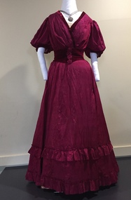
Clothing - Cerise Silk & Velvet Ball Gown, c.1901
The Fashion & Design collection of the Kew Historical Society includes examples of women’s, men’s, children’s and infants’ clothing from the 18th, 19th and 20th centuries. Items in the collection were largely produced for, or purchased by women in Melbourne, and includes examples of outerwear, protective wear, nightwear, underwear and costume accessories. This gown is believed to have been owned and worn by a member of the Smart family of 'Turinville', in Barnard Grove, Kew.Two-piece dress comprised of a bodice and floor length skirt made of a soft, lightweight cerise coloured silk fabric. The bodice features a v-shaped rear neck. A wide velvet cummerbund is part of the outfit. Dated to c. 1901. (Measurements: Length 132 x Waist 62-73, Chest 76 cm)australian fashion - 1900s, ball gowns - 1900s, evening dresses, evening wear, women's clothing -
 Glen Eira Historical Society
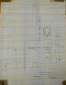
Plan - Brady Road, 10, Bentleigh East
A two page letter, dated 20/03/1973, from J M Smith and Emmerton Solicitors on behalf of Mrs J V Maxted to S P Simmons Estate Agent, requesting a sworn valuation of property at 10 Brady Road, Bentleigh East. The file also includes a photocopy of the certificate of title of the property, dated 28/02/1973. The certificate of title includes a plan (57mm x 65mm) of the property. The file also includes a two page letter, dated 30/03/1973, from S P Simmons responding to the request for valuation. Also included is a copy of these two pages. The file also includes one page of handwritten working notes for the property valuation including measurements and sales history of the property. The file also includes a hand drawn plan (114mm x 163mm) of the property with measurements.maxed j v, bentleigh east, brady road, wingate street -
 Kiewa Valley Historical Society
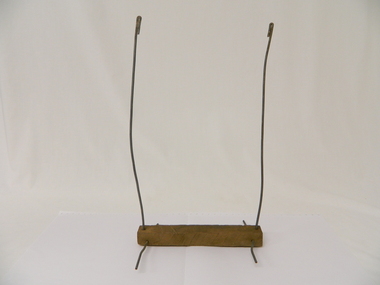
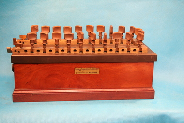
Tobacco Grading Dividers x 6, 1962
Tobacco farming began circa 1960 in the Kiewa Valley and consequently became one of its major industries. Many of the Italian families were involved in tobacco farming.Historical: This equipment was used on one of the first tobacco farms in the Kiewa Valley at Mongans Bridge. The dividers were home-made showing the resourcefulness of farmers living in the Kiewa Valley. Provenance: This tobacco farmer came from Italy and was sponsored to visit a tobacco farmer in Myrtleford to learn how to grow tobacco so that he could transfer those skills to his own farm in the Kiewa Valley.Wood plank with wire attached through a hole at each end in from side edge to create a stand. Another piece of wire stands vertically and is folded over to create blunt edge at the top. At the bottom it goes through the wood and along a bit to hold the wire in place. There are 6 dividers and because they are handmade the measurements vary slightly. tobacco. kiewa valley. mongans bridge. parmeson. rossaro, lorenzi brothers. grading dividers. -
 Federation University Historical Collection
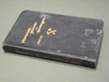
Book, Prospecting, Locating and Valuing Mines, 1902
This book was most probably used at the Ballarat School of Mines.Black covered book with gold title. 381 pages. The book was 'a popular treatise for the use of prospectors, investors and Mining Men generally; with an account of the Principal Minerals and Country rocks; Ore Deposits; Locations and Patents; the early Development of Mines; Earthy Mineral Products; Coal; Gold gravels and gravel Mining; Measurement of Water; and Artesian Wells'.mining, ballarat school of mines, water, geology -
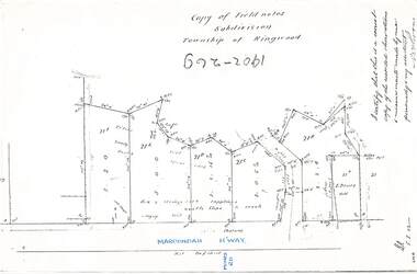
 Ringwood and District Historical Society
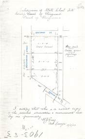
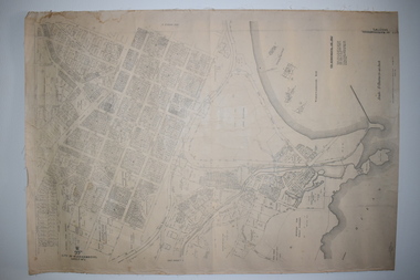
Document - Copy of Lands Department Field Notes - Subdivision of State School Site, Township of Ringwood, Victoria, Field Notes 1903/83 - Part of O.P. R72C Surveyed 13/2/1903
Foolscap size photocopy of survey map with handwritten notations. References include Everard Street, Old Lilydale Road (Maroondah Highway), Dublin Road, poor soil, coarse grass, saplings, I certify that this is a correct copy of the recorded observations & measurements made by me personally (signed) R.J. Gray Autorised Surveyor 13/2/03. -
 Warrnambool and District Historical Society Inc.
Documents Maps (3) - Warrnambool Town Allotments, City of W'bool Parish of Wangoom Country of Villiers, 1948
These maps were produced in 1948 and they contain maps of allotments within the city of Warrnambool, including the Central Business District, up to 1948. The details given on each allotment show the allotment and section numbers, the measurement in acres, the name of the original purchaser of the lot and the date of the first sale. The Warrnambool and District Historical Society owns several copies of these maps but these ones are originals.These three maps are of great significance because they give the names of land purchasers in Warrnambool from the date of the first land sales in 1847. They are a most valuable research tool and can be scanned and photocopied etc.These are three sheets of cream paper pasted on to linen. The sheets have black and white printing and map work. Some of the edges are a little frayed and there is some staining, particularly on the backs of the sheets.‘City of Warrnambool Parish of Wangoom County of Villiers Sheet 1’ ‘City of Warrnambool Parish of Wangoom County of Villiers Sheet 2’ ‘City of Warrnambool Parish of Wangoom County of Villiers Sheet 3’city of warrnambool, warrnambool maps, warrnambool town allotments 1948, land purchases -
 Lakes Entrance Historical Society
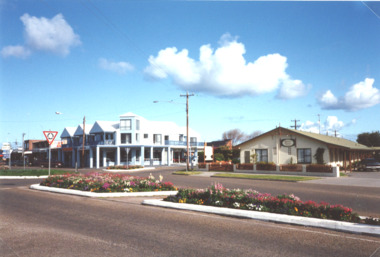
Photograph - Esplanade Lakes Entrance Victoria 1999, M Holding, 1999
intersection of Myer Street with Church and Roadknight Streets taken from Police Station corner shows flower gardens in traffic islands, Myer Street businesses and holiday units opposite Police Station Lakes Entrance Victoria 1999 Inscriptions and markings Languages Production methods Materials Dimensions No dimensions recorded Other measurements Duration Weight Weight unit Colour photograph of roundabout at intersection of Myer Street with Church and Roadknight Streets taken from Police Station corner shows flower gardens in traffic islands, Myer Street businesses and holiday units opposite Police Station Lakes Entrance Victoriabusinesses, roads and streets -
 Rutherglen Historical Society
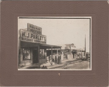
Image, c1920
Parletts owned and operated a timber yard near the railway station in the late 1800s to early 1900s. Parlett's store was situated in Audley Street opposite the wheat silos. Ada Parlett, W. J. Parlett's niece is a concert pianist.Photograph of Parlett's Store, Rutherglen with Mr W.J. Parlett and Mr Bob Ready standing outside store, black and white, mounted on thick beige card.On verso: "Elderly man = W J (Bill) Parlett, Rutherglen - a prosperous man. Father of Florie who also worked in her father's timber business and understood timber measurements. Florie remained single and died in Rutherglen."parlett, parletts store, w j parlett, audley street, bob ready, william james parlett -
 Bendigo Military Museum
Photograph - RASvy Surveyors in the field, c1950s – 1960s
This is a set of 1photographs of surveyors in the field measuring distances using chains, taking observations using theodolites and operating electric distance measurement equipment. They were probably employed in establishing mapping and geodetic control operations or the surveyors may have been in training. The photos were most likely taken in the 1950s and 1960s. Photos .1P to .6P feature personnel setting up geodetic survey chaining equipment to measure distances. The surveyor in Photo .5P is LTCOL Howard Angus Johnson MBE who served from 1936 to 1954. The RA Svy surveyor in photos .7P to .12P were using a theodolite to take angular measurements. They were usually supported by an observer who recording their readings on a booking form. The surveyor in Photo .10P and .11P is LTCOL Jorge Gruszka, who served from 1955 to 1985. He was CO of the Army Survey Regiment from 1982 to 1985. The surveyor in photo .13P is cutting an identification blaze on a tree using a hammer and chisel. The tellurometer in Photos .14P to .16P was a MRA1 microwave Electronic Distance Measuring instrument (EDM) introduced in 1958. It and later models were man-portable systems that improved geodetic survey efficiencies for rapid network extension and densification replacing triangulation with EDM and theodolite traverse sometimes using Bilby Towers to extend line lengths. The surveyor with the slouch hat is Colonel James ‘Jim’ Leslie Stedman, who served from 1941 to 1978. He was Director of Military Survey from 1975 to 1978 and was appointed as Colonel Commandant (honorary appointment, Retd) of the Royal Australian Survey Corps from 1978 to 1983. Jim Stedman is demonstrating EDM equipment.This is a set of 17 photographs of surveyors in the field measuring distances using chains, taking observations using theodolites and operating electric distance measurement (EDM) equipment. c1950s – 1960s. The photographs were printed on photographic paper and are part of the Army Survey Regiment’s Collection. The photographs were scanned at 300 dpi. .1) - Photo, black & white, c1950s, unidentified personnel using geodetic survey chaining equipment. .2) to .4) - Photo, black & white, c1950s, geodetic survey chaining equipment. .5) – Photo, black & white, c1950s, Jim Stedman using geodetic survey chaining equipment to measure distances. .6) - Photo, black & white, c1950s, Unidentified personnel geodetic survey chaining equipment. .7) – Photo, black & white, mounted on card, c1950s. Unidentified surveyor undertaking observations on a coral reef using a theodolite. .8) – Photo, black & white, c1950, unidentified surveyor undertaking observations with a Tavistock theodolite. .9) – Photo, black & white, mounted on green card, c1950s. Unidentified surveyor undertaking observations using a plane table. .10) – Photo, black & white, c1955, Jorge Gruszka undertaking observations with a theodolite. 7/55 Basic Survey Course Balcombe. .11) – Photo, black & white, c1950s, Jorge Gruszka undertaking observations with a theodolite. .12) – Photo, black & white, c1946-1948, unidentified surveyor undertaking observations with a theodolite to gain control for the mapping of the Snowy Mountain Diversion Scheme. .13) – Photo, black & white, c1950s, unidentified surveyor cutting a blaze in a tree. .14) and .15) – Photo, black & white, c1960s, Jim Stedman demonstrating EDM equipment. .16) – Photo, black & white, c1960s, L to R: Jim Stedman (probably) and unidentified surveyor demonstrating EDM equipment. .17) – Photo, black & white, 1956, Operation Cutlass - Surveyors SPR W. Crane and J.A. Campbell undertaking observations with a theodolite in extreme conditions..1P on back - First Order Chaining Equipment .2P on back - First Order Chaining Equipment .3P on back - Full catenary 1800 – 1960 replaced by EDM .4P on back - First Order Chaining Equipment .5P on back - H.A. Johnson, Benambra baseline? 1st Order Chaining .6P on back - Chaining .7P on front - Difficult observing conditions especially when the tide is in. The station is sighted (sic) on a coral reef. .8P on back - Tavistock. .10P on back of duplicate in Photo Folder 14 – George (sic) Gruszka 7/55 Basic Survey Course Balcomme (sic) 1955/56 .14P and .15P on back - Jim Stedman demonstrating early EDM equipment.royal australian survey corps, rasvy, army survey regiment, army svy regt, fortuna, asr, surveying -
Glen Eira Historical Society
Plan - Oswald Street, 6/17, Elsternwick
Copy of letter to Mr. and Mrs. J.M. Cunningham from sworn valuator W.V. Scott regarding detailed valuation of 6/17 Oswald Street Gardenvale dated 27 September 1977. Handwritten notes and plan recording the measurements of all the rooms. A cover copy letter to Mr. and Mrs. J.M. Cunningham from W.V. Scott 27 September 1977 with handwritten notes.cunningham j.m., oswald street, elsternwick, home units, verandahs, plans, brick houses, scott. w.v., bay windows, valuation -
 Old Colonists' Association of Ballarat Inc.
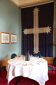
Photograph - Colour, Dining at the Ballarat Old Colonists' Hall, 2017, 23/03/2017
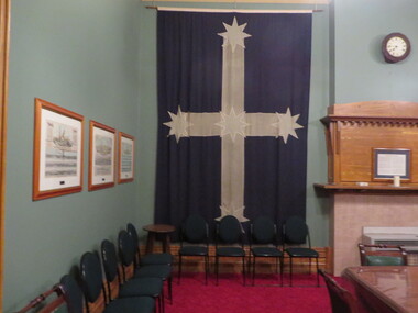
The Eureka Flag hanging on the wall is an exact replica of the Southern Cross flag which flew over the Eureka Stockade. It was copied from the original flag held by the Art Gallery of Ballarat. Exact measurements were taken from the flag and the replica was made by George Lemke and Co. The replica was made because the original was in fragile condition. (Ballarat Courier, 16 February 1965)Colour photograph of the Eureka Flag behind a set table in the Old Colonists' Hall, Ballarat.ballarat old colonists' club, ballarat old colonists' hall, dining, eureka flag replica, eureka flag -
 Old Colonists' Association of Ballarat Inc.
Flag, Stephen Carter, Old Colonists' Association of Ballarat Eureka Flag Facsimile, 1964
The Eureka Flag hanging on the wall is an exact replica of the Southern Cross flag which flew over the Eureka Stockade. It was copied from the original flag held by the Art Gallery of Ballarat. Exact measurements were taken from the flag and the replica was made by George Lemke and Co. The replica was made because the original was in fragile condition. (Ballarat Courier, 16 February 1965)Eureka Flag facsimile displayed at the Old Colonists' Hall, Ballarat.ballarat old colonists' club, ballarat old colonists' hall, dining, eureka flag replica, eureka flag, george lemke and co -
 Ringwood and District Historical Society
Document - Copy of Lands Department Field Notes - Subdivision of Ringwood, Victoria, Field Notes 1904/188 - Part of O.P. R72D Surveyed 28.4.1904
Foolscap size photocopy of survey map with handwritten notations. References include Mount Dandenong Road to Lilydale, M. Dickson (sold), Church of England, P. Schonnenberger, Helen Lindsay, W.B. iron roof & shingles, I certify that this is a correct copy of the recorded observations and measurement made by me and my assistant (signed) W. Thorn 12/5/04 -
 Ringwood and District Historical Society
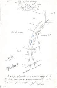
Document - Copy of Lands Department Field Notes - Township of Ringwood, Victoria, Field Notes 1913/163 - Part of O.P. R72D surveyed April 1913
5612b Foolscap size photocopy of survey map with handwritten notations. References include Mines Road, New Lilydale Road (Maroondah Highway), (area) Held for mining, Recreation Reserve, Sec D, Sec E, I certify that this is a correct copy of the recorded observations & measurements made by me personally (signed) R.J. Gray 2/4/13. -
 Bendigo Historical Society Inc.
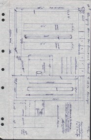
Document - CENTRAL DEBORAH GOLD MINE - PLAN OF CHANGING HOUSE
Hand drawn plan for Changing House for Central Deborah G. M. Co. Bendigo. Drawn by A. Richardson 14/11/1971. Drawing has approx. measurements and is not drawn to scale. Also some Central Deborah Gold Mine Information . Ref. Mines Dept. Surface Plan 15/1/1954. Written by A Richardson 14/12/1971.mine, gold, central deborah gold mine, central deborah gold mine, plan of changing house, a richardson, mines dept. surface plan 15/1/1954 -
 Bendigo Historical Society Inc.
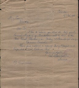
Document - LETTER TO MR. J EVANS OF SEBASTIAN, 1906
Document. Letter to Mr. J. Evans of Sebastian. Letter dated 19 Nov. 1906 to Mr. J. Evans of Sebastian from A. N. Presswell, Manager of Ram's Horn Company. Letter states about General Meeting of Shareholders to be held at Sebastian State School on Fri. 23 Nov. 1906. Pencil marks on back indicating hardware measurements and sundries.cottage, miners, mr. j. evans, a. n. presswell, ram's horn company, sebastian state school. -
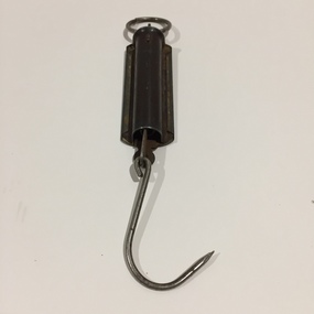 Kew Historical Society Inc
Equipment - Weighing Instrument, Pocket Balance, Twentieth Century
Small hanging scales at the top of which there is a metallic ring to fasten the object. This is attached to the main body which on one side has measurements inscribed into the metal surface. Inside the body is a spring loaded mechanism which moves along the scales when weight is added to a hook at the bottom of the shaft. [Ed. The maker's initials have not to date been identified.]"Pocket Balance / MR Product / Made in Australia"pocket balance, hanging scales, weighing instrument -
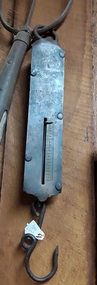 Mont De Lancey
Tool - Spring Balance Scales, Salters
Used in the late 19th and early 20th century.A vintage No 2 Class II Salters Improved Spring Balance weigh scale with a weight guage of 0 - 40 lbs. It is made of metal with four rivets holding the front measurement panel covering the spring with a ring at the top and a hook at the bottom to hold the item being weighed. It was manufactured in England by Salters and used in the late 19th and early 20th century.'No 2 Class II Salters Improved Spring Balance weight guage 0 - 40 lbs. Manufactured in England by Salters'''spring balances, scales, balances, weighing instruments -
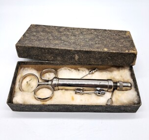 Glenelg Shire Council Cultural Collection
Functional object - Veterinary Syringe, 1900s
This syringe would have been used by a vet to administer drugs and medicines to animals.The Glenelg Shire has a strong farming industry and community. Vets were and still are invaluable to the community. This was donated by a worker at Portland Veterinary ClinicGrey mottled cardboard box containing a silver coloured syringe. There are also four needles. The syringe and needles are on cotton wool. The syringe has three circular rings at the top. Two are attached to the main body of the syringe and the third is attached to the plunger. The plunger has numerical measurements on it. The end of the syringe can be screwed off in order to place in the needle required.Plunger: 0 2 4 6 8 10 rural, agriculture, farming, portland, glenelg shire -
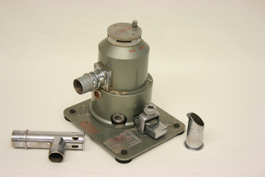 Geoffrey Kaye Museum of Anaesthetic History
Tecota trilene inhaler, Cyprane Ltd
The item was donated by Dr K McCaul of the Royal Women's Hospital, Melbourne, in 1966.Anaesthetic trilene was administered to the patient via rubber tubing from the Trilene inhaler, within which the anaesthetic was converted into a vapor. The cylindrical metal apparatus sits atop a flat, square stand with four black rubber feet. Item includes ports and valves for connection to a face mask and vaporising chamber, as well as mask attachment and metal pouring jug with spout.Red markings identifying the manufacturer and the measurement scale are located on both the stand and top twist dial. The base of the mask attachment piece is inscribed with the manufacturer's details: 'Cyprane Ltd'. The metal beaker is engraved with a line marked at the 15cc level. trilene inhaler, tecota, anaesthesia, beaker, mask, vaporise, obstetrics, childbirth, dr k mccaul royal women's hospital melbourne, 1966, vapor, face mask, vaporising chamber, cyprane ltd, keighley -
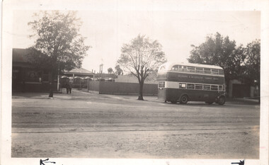 Melbourne Tram Museum
Photograph - Clifton Hill depot - double deck bus, Frank Shennen, 26/2/1941
Photograph shows a view from the street of Clifton Hill depot with cable trailers and a double deck No. 225 passing the depot in Queens Parade Clifton Hill. Photo by Frank Shennen 26/2/1941. Photo taken after the closure of the Bourke St lines in Oct. 1940.Yields information about Clifton Hill cable tram depot or car house and the use of double deck buses. Black and white photograph with notes on the rear.On rear in pencil "Clifton Hill cable car depot showing trams in yard and new bus in foreground 26/2/1941. 3399 Truck Bus FS. Has measurements and number "169" in pencil in top right hand corner.tramways, cable trams, clifton hill, double deck buses, bus 225 -
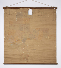 Warrnambool and District Historical Society Inc.
Map - Soldier Settlement Map, Soldier Settlement Commission, Tarrone Estate Alex Boyd, 1940s
This is a map of the Tarrone Soldier Settlement land divisions probably produced by the Soldier Settlement Commission. The map is incomplete with lots 48,49 and 50 missing. The Soldier Settlement Commission purchased 23,373 acres of Tarrone Station from the Boyd brothers in 1947 and the sub divided lots were occupied by soldier settlers commencing in 1949. Tarrone Station was established in 1840 by Doctors Kilgour and Bernard and the Boyd brothers secured the free hold in the 1890s and retained it until 1947. The map hung for many years in the Warrong school near Hawkesdale.This map is of considerable interest as an original item from the establishment of the Tarrone Soldier Settlement..The map is made of brown cloth and creased. The edges are tattered and there is a piece missing at the top. It is a map of allotments, hand drawn and with faded colours in red, blue and yellow. The names of localities and land holders are hand written in ink and chalk. The map is contained within two pieces of wood at the bottom and the top. There are two screws and a cord to hang on a wall. A scale of measurement is shown under the map. tarrone soldiers settlement, boyd brothers tarrone -
 Ringwood and District Historical Society
Document - Copy of Lands Department Field Notes - Subdivision Township of Ringwood, Victoria, Field Notes 1902/269 - Part of O.P. R72D surveyed in 1902
Foolscap size photocopy of survey map with handwritten notations. References include Maroondah Highway, (opposite) Mines Road, Ti tree, Sandy soil, heath, spear grass, box & stringy bark sapplings, gentle slope to creek, E. Drury. I certify that this is a correct copy of the recorded observations and measurements made by me personally and my assistant (signed) W. Thorn. -
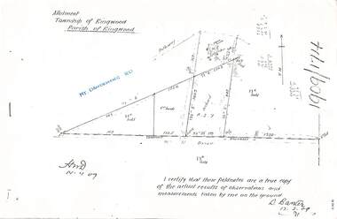 Ringwood and District Historical Society
Document - Copy of Lands Department Field Notes - Parish of Ringwood, Victoria, Field Notes 1909/174 - Part of O.P. R72D surveyed 12.3.1909
Foolscap size photocopy of survey map with handwritten notations. References include Mount Dandenong Road, pathway, 2 room house, scillion, shed, WC, 17C sold, Cr lands, orchard, 17E sold, Township boundary, I certify that these field notes are a true copy of the actual results of observations and measurements taken by me on the ground (signed) D. Barker 12.3.09. -
 Bendigo Historical Society Inc.
Plan - MARKS COLLECTION: PLAN EXTRA BOILER LANSELL'S 180 MINE
Engineering drawings for the (written on bottom of plan) 'No 2-arrangement extra boiler for Lansells Proprietary little 180 Mine Bendigo Plan shows chimney - side elevation, measurements of chimney, flue, boiler (and existing boiler, existing loco boiler) On bottom of plan: Scale 1/4 inch = 1 foot. Hargreaves & Daggar, Consulting Engineers, Victoria Chambers, Bendigo.mining, equipment, lansell's little 180 mine -
 The Ed Muirhead Physics Museum
Resistance box
Wooden box with brass top and 24 knobs (22 larger and 2 smaller) on the right-hand side. In addition there are two extra knobs on the right side of the top, as well as two removable oval access panels with handles on each of the ends.Stamped on top of box: a coat of arms 'HARTMANN OF BRAUN A/M' 'RICHTIG BEI / 20 / GRAD CELSIUS' increments for measurement On front side: Sticker labelled 'NATURAL PHILOSOPHY LABORATORY / NO 7 / UNIVERSITY OF MELBOURNE' Stamped on end of metal top: 'No. 2665'hartmann of braun, resitance decade box, resistance box, electical instruments, frankfurt, natural philosophy laboratory -
 City of Greater Bendigo - Civic Collection
Instrument - Gunter Chain, not known
Gunter's chain (also known as Gunter’s measurement) is a distance measuring device used for surveying. It was designed and introduced in 1620 by English clergyman and mathematician Edmund Gunter (1581–1626). It enabled plots of land to be accurately surveyed and plotted, for legal and commercial purposes. The provenance of this particular Gunter Chain is unknown but it is believed to be used either by the City of Bendigo / Sandhurst or the Lands Department locally when measuring and laying out plots and streets locally. A 66-foot (20.1 m) chain divided into 100 links, marked off into groups of 10 by brass rings or tags. Each link is 7.92 inches (201 mm) long. A quarter chain, or 25 links, measures 16 feet 6 inches (5.03 m) also called a a rod (or pole) measure. Ten chains measure a furlong and 80 chains measure a statute mile. city of greater bendigo surveying -
 Department of Energy, Environment and Climate Action
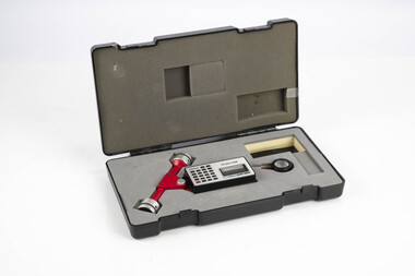
Planimeter (roller digital)
The rollers move over the map as the tracing arm is used to follow the boundary to be measured. The wheels allow unlimited horizontal travel and vertical travel within the limits of the arm movement. They measure in the X and Y directions Reading from the digital scale the area in square centimetres could be measured. Knowing the scale of the mapsheet the figure was converted to areas or hectares Generally at least three measurements were taken to ensure accuracy and precisionPlanimeter used to measure areas from scale maps. Includes box but no charger Plancom KP90forests commission victoria (fcv), forest measurement, surveying -
Frankston RSL Sub Branch
Memorabilia - Level, Abney
Square gunsight telescope.An Abney level and clinometer, is an instrument used in surveying which consists of a fixed sighting tube, a movable spirit level that is connected to a pointing arm, and a protractor scale. An internal mirror allows the user to see the bubble in the level while sighting a distant target. It can be used as a hand-held instrument or mounted on a Jacob's staff for more precise measurement, and it is small enough to carry in a coat pocket -
Glenelg Shire Council Cultural Collection
Photograph - Sheet of 2 black and white contact prints from glass plate negatives, 1960-1970
Sheet of 2 black and white contact prints from glass plate negatives. Measurements are 11.8 x 16.1 cm for both prints. Top: Image of stone house with shingle roof and stone chimneys. Veranda with iron support poles and lacework. Vines growing up poles. (same house as 5622) Front view. Bottom: Man on horse. Cypress pines, wooden fence behind.