Showing 378 items matching "north court"
-
 Bendigo Historical Society Inc.
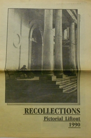
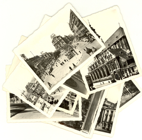
Newspaper - PETER ELLIS COLLECTION: RECOLLECTIONS PICTORIAL LIFTOUT
Historical lift out. Newspaper. Titled RECOLLECTIONS Pictorial Lift out 1990.1 looking down Mitchell St. from Railway Bridge. 2 Original railway station viewed from Mitchell St. bridge. 3 The great extended Hustlers mine. 4 1873 photo recently extended town hall with corn exchange at front left. 5 looking north westerly from city rec reserve at royal hustlers. 6 children play on mullock heap in front of a view of westerly quarter of Sandhurst. 7 Bank of Victoria, Mitchell St. left is Bendigo's original post office. 8 Looking down from what is now Rosalind Park. Shamrock Hotel can be seen on corner of Williamson St. and Pall Mall. This photo predates the construction of post office and law courts. 9 girl eating fairy floss. 10 4 kids on 1 horse in procession. 11 monkey and pedal car, a novelty attraction 1940's. 12 pony rides. 13 flying horses (ride). 14 processions past city hall. 15 Original ANZ bank corner Williamson St. & Pall Mall. 16 Chinese Dragons Bendigo Easter Fair 1940's. 17 City Hall viewed from Bull St. 18 City Hall original ceiling. 19 new town hall 1861. Mike Butcher, local historian. 21 Interior plan of city hall (ground floor) 22 circa 1920's 23 Tattered fragment original architect's drawing. 24 original assembly room. 25 Camp Hill PS Shamrock hotel without top story 27 shop with signage advertising Bushells, Bex and Swallow's Biscuits. 28 View from where fountain is now. 29 Hargreaves St. Looking south, now Hargreaves mall. Horse drawn water tank watering down road. 30 Central Deborah Gold mine poppet head. 31 Borough town hall, tram ways. 32 Original ANZ Bank corner Williamson St. and Pall Mall, demolished in mid 1960's. 33 Bush's store corner Williamson and Myer streets.34 Men on boat, don't know what or where. 35 Shearers. 36 men on a three wheeled bike. 37 4 Gold miners with shovels. 38 6pm closing, no trade Sundays, no women in main bar. 39 Peaceful scene Castlemaine 1940's Photographer Alan Doney. 40 Qantas Jet the City of Bendigo Tullamarine Airport. BCV-8 camera man & Advertiser photographer. 41 Ladies. 42 Tennis -> men and women (women in hats). 43 Sandhurst footy team. 44 Early school photos.bendigo, history, photographic history -
 Ringwood and District Historical Society
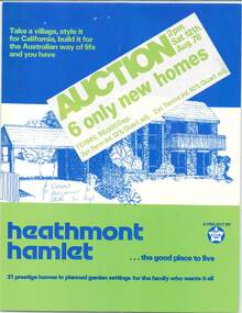
Flyer - Auction Sale, Heathmont Hamlet, Yarang Court and Westmore Drive, Heathmont, Victoria - 1978
Multi-fold promotional brochure with project home style images and floor plans. Six of 31 planned homes to be auctioned on Saturday 12th August, 1978. A project by Star Homes. Auctioneers/Agents - Bill Gefland, 71 Kooyong Road, Caulfield North. Ph: 5090211 AH. 203807, 8763939. Consultant - Enid M. Davies. Terms $6000 deposit, 3 year term interest 12% quart adj. 2 year term interest 10% quart adj. Home style images: The Atlas Ole, The Argo, The Atlas Pioneer, The Mira, The Alpha, The Libra, The Tucana, The Venus. Illustrated front cover - Libra 77. -
 Whitehorse Historical Society Inc.
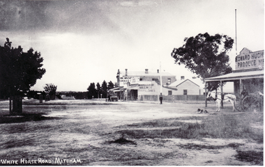
Photograph, North Corner of Whitehorse & Mitcham Road, Mitcham, c1920's
Black and white photo of the northern cnr Whitehorse and Mitcham Roads, Mitcham, showing Hughs Produce Store, with his white horse and delivery waggon outside. This was later the site of Mirama Court, later to be refurbished as shops and offices.|The vacant land on the far corner became a grocers shop and later the Westpac Bank. It is currently (2005) a computer sales shop.hughes produce store, mitcham road, mitcham, whitehorse road mitcham, mirama court mitcham, westpac bank -
 Glen Eira Historical Society
Document - TOURS
There are two copies of the Discover Caulfield guide produced by the Caulfield Historical Society. One from 1982 which contains twelve pages, seven of which are typed and the last five a continuation of the guide added later, hand-written. The other is a modern typed version of the same document, including information at the end that "Notes prepared by R. Ballantyne, 25th July, 1982, updated by Betty Snowball, 1992 and Gladys Vallati 4th August, 1995". They both detail a pictorial tours of the mansions and gardens in the City of Caulfield, similar but not identical.caulfield, mansions, gardens, homes, ‘lirrewa’, lirrewa grove, caulfield city hall, smith sydney, ‘halstead’, bambra road, halstead road, caulfield historical society, messrs. upton and smith, civic establishments, dickson james dr., houses, national trust, st. stephen’s church, balaclava road, gothic (revival) architecture, messrs. haddon and henderson, st. aloysius, archbishop of melbourne mannix dr., caulfield park, hawthorn road, inkerman road, kambrook road, paddy’s swamp, cannizzo philip, caulfield city council, trams, orrong road, grimwade house, ‘harleston’, grimwade frederick sheppard, primary schools, caulfield art centre, ‘stanmark’, art galleries, ‘craigellachie’, person william, pearson eliza, francis newton mr., greenmeadows gardens, milburn grove, greenmeadows house, lempriere john, mayors, ‘glenfern’, boyd john captain, boyd martin, ‘myoora’, alma road, ‘bagatelle’, christian thomas, henderson anketell, flats, building construction, ‘burreel’, kooyong road, burreel avenue, francis john, stephen sidney, allan george l., ‘royston’, renwick s. mrs., sargood frederick sir., ‘glen eira’, ricketson henry, caulfield hospital, royal southern memorial hospital, caulfield general medical centre, ‘ripponlea’, reed and barnes, architects, towers, rippon emma, rippon thomas, guilfoyle william, employees, ‘the village houses’, regent street, st. george’s road, cottages, bent thomas sir., jones louisa mrs., nathan benjamin, ‘anselm’, glenferrie street, queen anne style, haddon robert, historical buildings, princes’ park, ‘glenmore’, watts thomas, more hugh, glenhuntly road, gates, villas, ‘hopetoun’, hopetoun street, webb charles, hopetoun hospital, harleston park, allison street, langdon montague, langdon harry joseph, ‘tarqua’, ‘labassa’, manor grove, koch john, robertson a. w., wagner john, ‘ontario’, trinity congregational church, grange road, glen huntly, churches, greek orthodox church, ‘fairfield hall’, north road, younger james, glenhuntly post office, smith alfred, smith anne, methodist church, ‘lambros the cobbler’, railways, ballantyne r., snowball betty, kahlyn private hospital, ‘kynaston’, st. mary’s jubilee school, festivals and celebrations, st. mary’s anglican church, church of england, bishop moorhouse, joynt donoman, elsternwick post office, elsternwick, elsternwick bowling club, elsternwick rsl, caulfield grammar school, davis henry rev., selwyn street, elsternwick railway station, glen eira road, barnett r. j. rev., tudor court, world war 1914-1918, ‘fairhaven’, hope george, caulfield library, plaques, cannons, ‘janvec joinery’, parkside street, ‘parkside court’, clarence street, ‘streetscene’, grange road, greenhouses, vallati gladys -
 Bendigo Historical Society Inc.
Document - VICTORIA HILL - RECOMMENDATIONS FOR VICTORIA HILL
BHS CollectionHandwritten notes on recommendations for cleaning up and signposting Victoria Hill. Also contains list of photos from the Bendigonian of 1899. List of photos: Shamrock Mine, Undershot Water Wheel at Diamond Hill for Phillips Crushing Battery. Mr. Ballerstedt's Crushing Battery at Victoria Hill, Thompson's Foundry at Castlemaine, Machinery made for Bendigo Mines, Air Compressor at Shenandoah Mine, Winding Engine at Koch's Pioneer Mine, Poppet Legs at Koch's Pioneer Mine, Air Compressor at New Chum Railway Mine, Fortune Hustlers G M Co Bendigo View of Mine, Winding Plant and Afternoon Shift and Underground Work in the New Chum Railway. Also mentioned are notes on Machinery made by Thompsons. Also, a carbon copy of Annual Report to Bendigo Branch Royal Historical Society, Victoria 1/7/71. Mentioned in the Report are: Historical Ball, The Central Deborah, Victoria Hill, Tours and Society Business. Albert Richardson document?document, victoria hill, recommendations for victoria hill, north old chum, ballerstedt's rich 24 yard claim, floyds battery lansell's big 180, the bendigonian 26/1/1899, 2/2/1899, 20/4/1899, 11/5/1899, 10/8/1899, 14/9/1899, shamrock mine, undershot waterwheel at diamond hill, phillips crushing battery, mr ballerstedt's crushing battery, thompson's foundry, shenandoah mine, koch's pioneer mine, new chum railway mine, fortuna hustlers g m co bendigo, new chum railway, st mungo lady barkly, catherine reef, new moon, rae's open cut, old court house eaglehawk, police barracks, vic wodetzki, joss house, central deborah, central nell gwynne, mr harold curnow, bendigo branch royal historical society victoria, mrs kingerlee, felicity kingerlee, mr h biggs, city council, rotary club of bendigo south, white hills cemetry, chinese joss house, bendigo pottery, mr derham, reservoir high, princess theatre, a n a hall, mr hattam, col. sprenger, survey corps, a richardson -
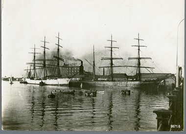 Flagstaff Hill Maritime Museum and Village
Photograph - Vessels, Sailing Ships, Circa 1910 - 1913
This photograph was one of ten photographs donated to Flagstaff Hill Maritime Museum and Village by Fred Trewartha. Frederick John Fox Trewartha (Fred) was a well-known Warrnambool businessman. He was born in Beeac near Geelong in 1920 and came to Warrnambool with his family as a very young child. He was apprenticed to his father John, as a saddler and later opened his own shop on Raglan Parade. He then moved into working with tarpaulins and canvases for the trucking industry. Fred was keenly interested in photography (and was a member of the Warrnambool Cine Club), yachting and boat building. He kept his yacht moored at Port Fairy for many years and participated in sailing events locally and interstate. He also built boats with his sons. He had the opportunity to meet many older sailors and it's thought this photo (and others in the set) may have been given to him by one of these men. Fred Trewartha died in 2016 in Warrnambool. There is some conflict re the identity of the ship in the foreground of this photograph. It has been identified as the "Dimsdale" by the original owner of this photograph and by the website "Photos of the Past" which have an identical copy of the photo, however the State Library of South Australia (who also have an identical copy of the photograph) have identified the date of the photograph as 1910 and the ship as the "Ainsdale". The "Dimsdale" and the "Lobo" were recorded several times in the local shipping news as being docked at the Port of Adelaide, at the same time, during the years 1912 and 1913, whereas the "Ainsdale" wasn't in Adelaide very often but was recorded as coming in and out of the Port of Adelaide in the years 1915 and 1916. On February 25th 1916, the two ships (the "Ainsdale" and "Lobo") were both in the Port of Adelaide at the same time, but the "Ainsdale" was loading at Outer Harbor and the "Lobo" was discharging timber at Corporation Wharf. The "Ainsdale" was owned by the same firm that had owned the "Dimsdale". The Dimsdale was a three masted steel ship built in 1890 by C. J. Bigger of Londonderry. It became notorious when it struck the Wonga Shoal lighthouse near Port Adelaide on the night of 17th November 1912, destroying the structure and killing two lighthouse keepers. The accident was investigated by the Marine Board, the Coroner, the Police Court, the Admiralty Court and by the Criminal Courts of South Australia where the Captain (John Jones) was charged with manslaughter and found "not guilty". The Dimsdale was sold to a Norwegian firm and its name was changed to "Kwango". It sank in 1915 near the Magdalen Islands in the Gulf of St. Lawrence. The "Lobo" was a well known "windjammer" trading from the Port of Adelaide to other parts of the world. For a number of years it was employed in the New Zealand and Tasmanian services, after which it made several voyages to North America. It was an iron barque of 945 tons, built at Sunderland in 1877 by Osbourne, Graham and Company. On October 18th 1916, the Lobo (owned by Walter and Morris, timber merchants) was on a voyage from Parapato (Mozambique) to New York with a cargo of mango bark and ebony, when it struck rocks and ran aground 30 miles east of the Angoche River in Portuguese East Africa. A detailed account of the incident, written by Mrs Murchison (the Captains wife who was on board with her two year old son) was published in the Adelaide newspaper "The Mail" on Saturday 9th December 1916. She, and several of the crew were put in a boat early in the morning and sent away from the wreck. Several hours later, they were joined by Captain Murchison and the remainder of the crew. They were in their small open boats for several hours before landing on a small uninhabited island where they remained for several days before being picked up by another vessel and taken back to Parapato. The captain was able to obtain a position on a steamer which took him and his wife and child back to England.This photograph is significant as a record of the world wide mercantile trade Australia was engaged in at the end of the nineteenth century and beginning of the twentieth century and as a record of the dangers faced by the crews of these ships.A black and white photograph showing two large sailing ships moored at a dock. There are industrial buildings in the background (one has smoke coming from its chimney) and several smaller craft (a rowing boat, two small boats that may be tugs and a little yacht) at the side of the ships. Pylons can be seen in the water and a metal fence is in the bottom right corner. On the back of the photo the words "Ship Dimsdale" and "Bk Lobo" are written diagonally across the top left corner in pencil. A beige paper label has been attached to the top right corner with the words "Dimsdale at Port Adelaide" and "Port Adelaide Historical Society may be interested" written in black ballpoint pen."Ship Dimsdale" / "Bk Lobo" ""Dimsdale" / at Port Adelaide" "- Port Adelaide Historical /Society may be / interested"warrnambool, dimsdale, lobo, barque lobo, port of adelaide, kwango, wonga shoal lighthouse, fred trewartha, ainsdale, frederick john fox trewartha, captain john jones, windjammer, iron barque, parapato -
 Ringwood and District Historical Society
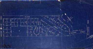
Map, Subdivision Plan of residential allotments in Mullum Mullum Road, Oliver Street and Lister Court, Ringwood, Victoria - (Undated)
Blueprint copy on cardboard backingNorth directional indicator includes name of Surveyor and Town Planner, Saxil Tuxen. -
 Bendigo Military Museum
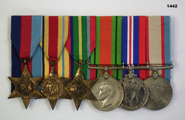
Award - MEDAL SET WW2, Post 1945
Edward Joseph Flynn VX28373 enlisted on 19.6.1940 in the 2nd AIF. Embarked for Eygpt 29.12.1940, disembark 29.11.1940, embark for Australia 5.2.1942, disembark 16.3.1942, embark for New Guinea 12.6.1942, disembark Sydney 8.12.1943 for leave, from here he spends time in hospital with Malaria then Dermatitis of the Face. Embark for Morotai 10.4.1944, disembark 22.4.1945, embark for British North Borneo 30.5.1945, embark for Australia 28.10.1945, disembark Brisbane 15.11.1945. On discharge from the AIF 6.12.45 he was still serving as a Gunner in 2/3rd Anti Tank Regt. He would also be entitled to the Australian Service medal 1945 - 75.Medal set, court mounted, set of (6) re E.J Flynn. 1. 1939-45 Star. 2. Africa Star. 3. Pacific Star. 4. Defence Medal. 5. War Medal 1939-45. 6. Australian Service Medal.1939 - 45"VX28373 E J FLYNN"numismatics- medals - military, medals, service awards, medals army -
 Bendigo Historical Society Inc.
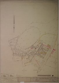
Plan - SANDHURST BOYS CENTRE COLLECTION: PART DETAIL SURVEY
Prepared by the Public Works Department for the Government of Victoria. Client is the Mental Health Department, Municipality is City of Bendigo. Site plan of area bounded by O'Dwyer St and Finn St, North Bendigo. Handwritten note on back - Update of whole centre 10/4/91. Details include: oval, tennis court, grandstand, area is bounded by an un-named watercourse. Also indicated are 14 nissen huts, 2 toilet blocks, 3 weatherboard buildings, 1 galvanised iron building,2 galvanised iron sheds (one new), residence, garage, fowl shed, and a carpark. bendigo, institutions, sandhurst boys centre, sandhurst boys centre site plan; -
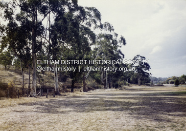
 Eltham District Historical Society Inc
Colour Print, David Taylor, Falkiner's Cottage, Ely Street, Eltham, c.1976
Viewed from the western boundary at the rear of Eltham High School looking southwest across part of what would be become the Cronus Court housing development. Aerial photos for 1976 reflect the undeveloped landscape as viewed. By 1981 the estate was well established with all houses built. Falkiner Cottage, also known as Maynard's Cottage. Falkiner was the original owner and Maynard the last owner. The cottage was located on the north side of Ely Street where present day #19 is situated. The cottage ran in a north-south orientation with an easterly aspect down the hill.david taylor collection, eltham, eltham high school, cronus court, ely street, falkiner cottage -
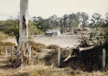
 Eltham District Historical Society Inc
Colour Print, David Taylor, Western boundary, Eltham High School, c.1976
View looking north towards intersection of Susan Street and present-day Withers Way, behind the school near the western boundary. To the left of the photo is the housing development of Cronus Court. Aerial photos for 1976 reflect the undeveloped landscape as viewed. By 1981 the estate was well established with all houses built.david taylor collection, eltham, eltham high school, cronus court, susan street, withers way -
 Ringwood and District Historical Society
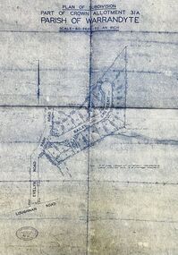
Map - Plan of Subdivision, Part of Crown Allotment 31A, Parish of Warrandyte - (Undated)
Facsimile blueprint copy of 24 residential allotments with property dimensions in Bailey Crescent (later Gabriella Court) and McEwan Street (later Suzanne Court) off Park Road and Evelyn Road, Ringwood North. Attached photocopy of undated map of allotment on south-east corner of Evelyn and Park Roads.Rubber stamp impression - J. Horne, Licensed Surveyor, 458 Nepean Highway, Frankston 31736. -
 Stawell Historical Society Inc
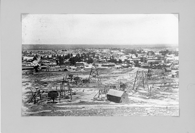
Photograph, Panorama of Stawell from Big Hill with Whims, Poppet Heads & Leaning Shed c 1878
Scene from Big Hill. Market Building in Skene Street at left of Stawell Court House. Businesses at corner of Sloane and Patrick Streets visible. Agnew Drapers store and buildings in upper Main Street visible Shows Mining activity in foreground 1878. Whim in foreground is No7 North Scotchmans and Whim next to that No8 North ScotchmansBlack & White Photograph from Big Hill. Market building left of Court house . Photo shows mining activity in the foreground, Stawell in the background c 1878. refer. Original c 1880 folder (room 2) from Don Rickard & Geoff Oates.stawell, panorama, streetscape, mining -
 Federation University Historical Collection
Photograph - Black and White, Tourist Scenes of Brussels
Nine black and white photographic views of Brussels. .1) Market Place .2) St James Coudenberg's Church .3) Hallepoort .4) Parc Royal .5) Memorial Egmont and Hornes .6) North Station (Gare du Nord) .7) Courts of Justice .8) Chapel Church .9) de Broukere Placechatham family archive, brussels -
 Bendigo Military Museum
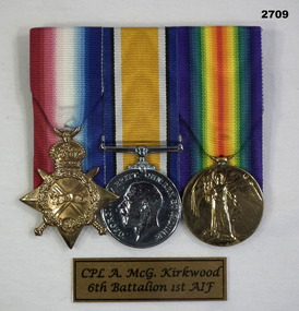
Award - MEDAL SET WW1, WW 1
Athol McGregor Kirkwood No 323 enlisted in C Coy 6th Batt AIF on 17.8.14 age 19 years 4 months. Embarked for Eygpt 19.10.14, embark for Gallipoli 5.4.15, awarded Distinguished Conduct Medal (DCM) north of Cape Helles Dardanelles on 8.5.15, promoted Cpl 9.5.15, KIA 27.7.15. Medal set - court mounted set of (3) Re. A. Kirkwood. .1) 1914 -15 star .2) War Medal 1914 - 18, Replica not engraved. .3) Victory medal 1914 - 1919"323 Cple A Mc G. Kirkwood 6 BN A.I.F”medals, military, bravery, passchendaele barracks trust -
 Bendigo Military Museum
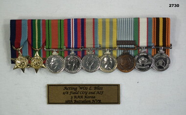
Award - MEDAL SET, WW2, KOREA, Post 1945
Leonard Edwin Bliss VX59955 enlisted in the 2nd AIF on 22.7.41 age 19 years. At discharge from the Army on 5.12.45 he was a Sapper in 2/8th Field Company. He re enlisted later No 3/400361 and served with 3 RAR in Korea. After that he served with the 38th Batt North Victorian Regiment. Medal set, miniatures, court mounting, set of (9) Re L.BLISS. 1. 1939 - 45 Star 2. Pacific Star 3. Defence Medal 4. War Medal 1939 - 45 5. Australian Service Medal 1939 - 45 6. Korea Medal 7. UN Medal with clasp "KOREA" 8. British commonwealth occupation forces medal Japan 9. Atomic tests medal 1952 - 1958medals, military, history, passchendaele barracks trust -
 Bendigo Historical Society Inc.
Postcard - Australia, Elliot Collection, 1895 - 1914
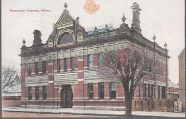
Thought to have originated in Austria in 1869, postcards first gained popularity in Australia in the 1890s.They were used to send short messages to friends and family. This collection was generated by Mary Emma Elliot of Talgarno. Talgarno is a rural locality in Victoria, Australia, situated on the southern shoreline of Lake Hume, about 23 km east of Albury-Wodonga. The collection contains postcards from across the world. Mary Emma Sibley was born in Ironbark, Bendigo in 1859. She married James Elliot in 1893 and they settled at “Kelso”, Talgarno. They had two children – Mona and Sibley. Mary Emma Elliot died in Melbourne in 1944, aged 84 years. Australian postcards collected by Mrs. James Elliot between 1898 and 1915. 1405.061 Mechanic's Institute, Albury 1405.062 Kiama, N.S.W. 1405.063 Dean Street, Albury, N.S.W. 1405.064 Union Bank and Post Office, Temora 1405.065 Middle Harbour, Sydney 1405.066 Sydney University, Sydney 1405.067 Botanic Gardens, Sydney 1405.068 Bridge Street, Sydney 1405.069 Botanic Gardens, Sydney 1405.070 the Two Bridges, Yass 1405.071 Court house, Yass 1405.072 Church of St. Augustine, Yass 1405.073 The Grotto, Church of St. Augustine, Yass 1405.074 Hume and Hovell Monument 1405.075 Flat Rock, Middle Harbour, Sydney 1405.076 the Dam, National Park, New South Wales 1405.077 Hamilton Hume's Monument, Albury Gardens 1405.078 the weir, Yass 1405.079 Lane Cove River, Sydney, N.S.W. 1405.080 Suspension Bridge, North Sydneypostcards, collecting, collections, talgarno -
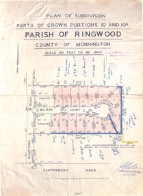 Ringwood and District Historical Society
Map - Plan of Subdivision, Parts of Crown Portions 10 and 10B Parish of Ringwood - 1958
Folded subdivision map of 15 residential allotments in McKay Court Ringwood, off Wantirna Road north of Canterbury Road. Rubber stamped by Surveyors and Chartered Engineers J.S. Watson & Associates, Mornington and South Yarra, with illegible signature dated 17/2/58. Handwritten notations indicating allotment sale names and amounts or where passed in. Accompanying clipping on scrap paper backing from Land Sale Brochure with description of available services and local facilities and terms of sale - £75 Deposit £10 Monthly.