Showing 401 items
matching white hills gardens
-
 University of Melbourne, Burnley Campus Archives
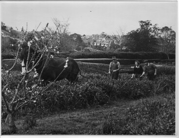
Photograph - Black and white print, Ploughing in Cover Crop, 1949
Identified by T.H. Kneen as, L to R George Manley (Stockman Assistant), Valerie Green (1st Year Student), Harold Marshall (Gardening Instructor- Orchard.)"Black and white photograph. 2 Instructors and female student with horse and plough in the Orchard. Well trimmed hedge at far side of field. Draught horse pulling the plough. Houses of Hawthorn on hill in background.On reverse,"Burnley Gardens. Ploughing in Clover Crop-Sept. 1949."instructors, female student, horse, plough, orchard, burnley gardens, george manley, stockman assistant, valerie green, harold marshall, gardening instructor, students working outside, draughthorse, cover crop -
 University of Melbourne, Burnley Campus Archives
Photograph, Ministry for Planning and Environment April 1966. Photographic Archive Project, Museum of Victoria, Display of Early Victorian Gardens, 1996
display, early victorian gardens, garden design, linton district, geelong, stockyard hill, amherst -
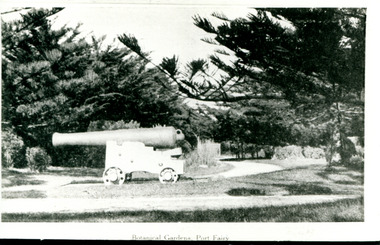 Port Fairy Historical Society Museum and Archives
Photograph
One of the large cannons located in Port Fairy in reply to the threat from foreign invaders. Originally located in the fort on Battery Hill they migrated to various destinations around the town. One of the two originally located at King George Square found its way to the gardens where it occupied several locations before resting at the car entrance to the Gardens - possibly when the Avenue of Honour was planted in Bourne Avenue. A great favororite with the kids of the town, both have now been returned to their original location where they are currently having their carriages refurbished.Black and white photograph of cannon situated in botanical gardensBotanical Gardens Port Fairycannon, gardens, botanical -
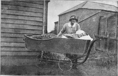 Royal District Nursing Service (now known as Bolton Clarke)
Photograph - Digital image, c.1920
This digital image is taken at the home of a Melbourne District Nursing Society (MDNS) patient, and depicts a MDNS Sister attending to a lady who is lying in a wicker bed pram in the rear garden of her home. The wicker bed pram enabled the lady to enjoy fresh air and to be moved about easily. The image shows the MDNS uniform of a grey cotton frock with white collar, and a grey brimmed hat with a red Maltese cross in the centre of the hatband. In 1885, 50 years after Melbourne was founded, it was recognized that nursing care was needed for the sick poor in inner Melbourne. The Melbourne District Nursing Society (MDNS) was founded in February 1885 with one Trained nurse, known as 'Nurse' in those days, and a second employed six months later,. The two Nurses worked in the now CBD, ie from Spencer Street to Spring Street and from Victoria Parade to Flinders Street. At that time they walked the streets and lane ways amid the slums of inner Melbourne carrying their nursing bags containing lotion, ointments, powders, liniment, bandages, dressings, a case of spirits, and the Nurse's own clean apron, soap and small towel. They supplied equipment on loan, such as earthenware hot water bottles, splints, urinals, bed pans, bed cradles, feeding mugs, and air-cushions as well as providing blankets and clean bed linen, and nightdresses as necessary. From its inception the Society was at the forefront of health care and liaised with Doctors. They provided high quality nursing care to a range of people, often in destitute situations, some lying on rags on the floor as they had no bed, others with just a bed and maybe a thin blanket, a chair and nothing else. Their ages ranged from babes, children, adults to the elderly. The Nurses gave medications as ordered, dressed wounds e.g. to the injured, and surgical cases, and to those with leg ulcers; attended to patients with ‘surgical ailments’ such as ‘hip disease’; gave care to those with acute illnesses such as bronchitis, pleurisy, pneumonia, measles, and scarlet fever, as well as those with chronic illnesses such as consumption (tuberculosis), heart disease, arthritis, cancer, debility, neuritis and paralysis. This image shows a Melbourne District Nursing Society (MDNS) Trained nurse (Sister) wearing a grey uniform with white collar, and a grey brimmed hat, which has a hatband with Maltese cross applied, standing behind and attending an elderly lady patient laying in a wicker bed pram outside her home. The Sister has her right hand resting on the pram and is looking down at the lady, and the lady, who has short grey hair, is smiling and looking toward the camera. Her body is covered with a floral cover. To the left, part of the horizontal weatherboards of a wooden house can be seen, and to the right and rear, a brick, tiled hip roof, building can be seen. The wicker bed pram has four spoked wheels and a metal frame that bends up to form a handle on its right hand side.melbourne district nursing society, mdns, mdns nurses, mdns patient care, mdns uniforms, rdns, royal district nursing service -
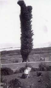 Lakes Entrance Historical Society
Photograph, 1920c
Black and white photograph of The Tree on Merrangbaur Hill. This dead iron bark tree covered with vine, was for many years a landmark for vessels at sea. View of sand hummocks and Cunninghame Arm in background. Lady seated on deckchair in Merrangbaur House garden, Lakes Entrance Victoria.guesthouses, topography, coast, local history -
 Surrey Hills Historical Society Collection
Photograph, 6a Thistle Street, Surrey Hills, 1924
One of the oldest homes in Surrey Hills. The photo was taken in 1924 when the property was purchased by Mr John Francis Evans, father of Mrs Lillian Austin. The Evans family came from Gembrook. John Evans was born in Wales; he and his wife Mary had 3 children, 2 daughters and one son. Mary Evans pre-deceased her husband, who died on 23 October 1924 at Hillsborough, 6A Thistle Street. The first owner of the property was Mrs Rachel Sweetnam (nee Lewis) who married Thomas Edward Sweetnam on 24 September 1884 at St John's Church, Camberwell. REF: THE ARGUS 4 Oct 1884 Thomas second eldest surviving son of Matthew Sweetnam married to Rachel (Ray) third eldest daughter of Captain T.D. Lewis, Culm Haven, Camberwell. Thomas was active in land sales and variously described as a land agent, real estate agent and auctioneer. The property - Hillsboro or Hillsborough - was originally a house on a farm of 10 acres owned by her. It became 6A Thistle Street. According to the Alan Holt property register Rachel Sweetnam owned the property prior to 1890 and a family tree on Ancestry.com has that it was owned by her in c1886. It is likely that at this stage the property was an investment rather than the Sweetnam's family residence. Other property owners or residents are: 1890 Selina Gaylor 1900 Stephen Pullen 1910 William Murray (draftsman) 1920 George C Hughes 1930 Arthur Leslie Austin (tram driver) 1980 Mrs Lillian Evelyn Austin Lillian Austin died on 19 August 1983 and the property was sold that year for $87,000. The house is still extant (January 2025). Note that we also have material / photos regarding George Hughes and family.Black and white photo of a timber home with brick chimneys and a (?) corrugated iron roof. There are sheds and outbuildings attached to the house. The garden looks untended. In the background a mature eucalypt tree can be seen.houses, hillsboro, timber houses, mrs lillian austin, hillsborough, selina gaylor, stephen pullen, william murray, george hughes, arthur austin, john francis evans, thistle street -
 Ballarat Heritage Services
Pamphlet - Photograph - Black and White, Wombat Hill Lookout (Pioneers Memorial}, c1935, c1935
Black and white photograph of the Pioneers Tower at Daylesford Botanical Gardens.daylesford, wombat hill botanical gardens, wombat hill, pioneers tower, lookout tower -
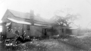
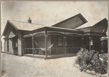 Bendigo Historical Society Inc.
Photograph - T C WATTS & SON COLLECTION: WHITE HILLS, NEXT TO CATHOLIC SCHOOL, 1927
BHS CollectionBlack and white photograph mounted on rectangular brown board. House, weatherboard , triple gabled corrugated iron roof, single chimney , wooden return verandah with balustrade, capitals to verandah posts. Exterior windows have awnings, two entrances from returned verandah, two deckchairs and hammock on verandah. Rock-bordered garden R.H. corner. Written on back of photo ' Roberts, White Hills, £1150 (crossed out) £850, next R.C. School'F.A. Jeffree, Bendigoresidential, roberts, white hills, t.c. watts and son, 1927 -
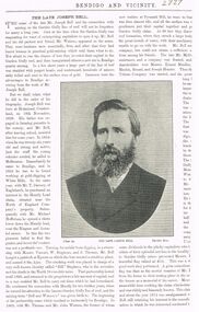 Bendigo Historical Society Inc.
Document - JOSEPH BELL: DOCUMENTATION
Joseph Bell - documentation on life of 'The Late Joseph Bell' - part of page from 'Bendigo and Vicinity (Watson and Bell - Garden Gully line of reef, Bendigo). Bad copy - right-hand column incomplete, no page number)Bendigo and Vicinityperson, individual, joseph bell, garden gully reef. mr watson, white hills, huntly lead claim, niagara mine, annabel mine, crushing plant "ajax" -
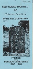 Bendigo Historical Society Inc.
Document - BENDIGO CEMETERIES COLLECTION: SELF GUIDED TOUR NO.7 DOCUMENT
BHS CollectionBlue coloured document, trifold. Self Guided Tour No. 7 of Chinese Section, White Hills Cemetery, Friends of the Bendigo Cemeteries 2-001 - 2002. Theme 'A hundred years after Federation' Map with numbered grave sites, with descriptions e.g. Louey Ah Pon, passenger involved in a fatal car accident with a bus on High St., a market gardener of Golden Square. Chung Fook Jao, committed suicide in his hut on the New Chum Mine site where he had worked the tailing for many years.Friends of the Bendigo Cemeteries 2000bendigo, cemetery, white hills cemetery tour -
 Surrey Hills Historical Society Collection
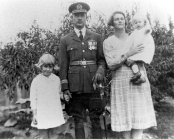
Photograph, William and May Palstra with Margaret and Jocelyn at 60 Guildford Road, Surrey Hills, 1920s, 1926
Date is approximate. William and May Palstra were married in 1920; 60 Guildford Road was their first and only home. William was with the university when he joined the Australian Flying Corps in WW1. He went back to university on his return from the war but in 1926 when the RAAF was formed he joined it as he had enjoyed flying. He took his family to England while he did 2 years training at the Imperial College in London under Air Vice-Marshall Jones. He was chosen as the Australian representative on a special flight of an experimental airship designed to fly over long distances. The test flight was destined for India, then on to Australia. Its passengers were high level British officials including the UK Secretary of State. It struck bad weather after crossing the Channel, clipped a hill and crashed in France. Some of the crew survived but William Palstra was killed. Mrs Palstra did not receive any compensation; only a small allowance, then cut during the Depression. She was given some support from the Returned Soldiers, Sailors and Airmen's association. Donor, Margaret Thornton was a daughter of William and May Palstra; one of her daughters, Julia Thornton still lives in the house in 2009. Donation form signed by Julia Thornton. Margaret and Jocelyn had a brother, also William. The house remains in 2009 with extensions to the rear and side.Black and white photo of William and May Palstra and 2 of their children in the garden of their home. William is in the uniform of the RAAF. He is holding Margaret's hand; Jocelyn is in her mother's arms.guildford road, raaf, australian flying corps, uniforms, william palstra, may palstra, margaret palstra, margaret thornton, jocelyn palstra, julia thornton -
 Surrey Hills Historical Society Collection
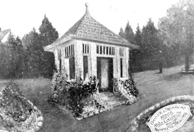
Photograph, Artist's impression of The Shrine in the Surrey Gardens
The photo comes from a souvenir brochure printed for the dedication of The Shrine on 7 April 1918, a copy of which is also held in the collection.. The Shrine was opened on Sunday 7 April 1918. Mrs C H D Steele, President of the local Patriotic League, is credited with the idea of building The Shrine as a fitting memorial to the WW1 soldiers of the district. The Surrey Hills Progress Association coordinated raising funds from local residents. John Kendrick Blogg carved the beautiful honor roll in Indian teak and Australian white mahogany and the design of the Shrine was by John Stevens Gawler, architect of Gawler & Drummond. Both men donated their services. It was one of the first WW1 memorials to be built and is noted for its use of Australian motifs, wattle blossom and gum leaves. The boomerang over the full width of the monument was said to be symbolic of both those who did and did not return. Surrey Hills Progress Association coordinated fundraising to build the memorial. There is a bound copy of a history of The Shrine by Robin Doble in the collection.Black & white photo of the artist's impression of The Shrine in the Surrey Gardens. surrey gardens, john kendrick blogg (mr), surrey hills progress association, john stevens gawler, gawler and drummond, the shrine, war memorials, sarah margaret russell (miss), sarah margaret steele (mrs), mrs charles henry dillon steele -
 Surrey Hills Historical Society Collection
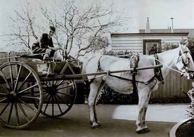
Photograph, Thomas William Hall of 10 Pembroke Street Surrey Hills, 1940
Date is approximate. Donor is the widow of Thomas Hall. Biographical notes provided: Thomas was born in Melbourne on 14/9/1928 and lived at Olinda until c1932 when his family moved to 10 Pembroke Street, Surrey Hills. He attended Surrey Hills State School, then went on to Box Hill High School (and / or Technical School - both are mentioned). He bought a horse and cart in order to be able to make deliveries for trades people and hence pay his way through technical school. He attended technical school 3 evenings per week studying building, carpentry, plumbing, electrical work and bricklaying. He built many homes in the eastern suburbs. He played tennis and attended church at Church of Christ. Married Margaret on 2/4/1955. Retired to Dromana where he was a member of the garden club at Redhill. Died 24/7/2004.Black and white photo of a boy identified as Thomas William Hall of 10 Pembroke Street, Surrey Hills sitting on a delivery cart with Snowy the horse in harness. "T Hall / ....." is painted on to the side of the cart. Taken in the backyard of his home in readiness for making deliveries."THOMAS WILLIAM HALL / BORN 14.9.28 DIED 24-7-04" in blue biro on rear of photo at top.hall, thomas william (mr), horse drawn vehicles -
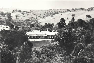
 Eltham District Historical Society Inc
Photograph - Digital Photograph, Alan King, Garden Hill, Eltham-Yarra Glen Road, Kangaroo Ground, 3 February 2008
The original house was built around 1850 was one of Kangaroo Ground's earliest homes, part of which remains today. Built by Scottish farmer Andrew Harkness who acquired the property in 1849 at the top of the hill with magnificent panoramic views as far as Kinglake, the same year he married Sarah Oswin. The property was known as Garden Hill from at least 1865. Andrew and Sarah had four sons and five daughters. Harkness was a founder of the Kangaroo Ground School and one of the first to suggest establishing the Eltham District Road Board (1858-71) of which he was a member, the pre-cursor to the Shire of Eltham (1871-1994). He was also a Trustee of the Kangaroo Ground Cemetery. His daughter Fanny married farmer Alexander White who purchased the property in 1893. Alexander White died in 1906 and ownership transferred to Fanny White. Son, Robert White was a Councillor of the Shire of Eltham at the time the Shire acquired two acres of land on the adjacent property from the Mess brothers for the creation of the Shire of Eltham Memorial Park (1921) in which the Shire of Eltham War Memoirial tower was erected (1926). Fanny White donated a small section of land from the Garden Hill property to facilitate entry access to the park. The White family sold the property to Sir Herbert Gepp in 1925. Covered under Heritage Overlay, Nillumbik Planning Scheme. Published: Nillumbik Now and Then / Marguerite Marshall 2008; photographs Alan King with Marguerite Marshall.; p29This collection of almost 130 photos about places and people within the Shire of Nillumbik, an urban and rural municipality in Melbourne's north, contributes to an understanding of the history of the Shire. Published in 2008 immediately prior to the Black Saturday bushfires of February 7, 2009, it documents sites that were impacted, and in some cases destroyed by the fires. It includes photographs taken especially for the publication, creating a unique time capsule representing the Shire in the early 21st century. It remains the most recent comprehenesive publication devoted to the Shire's history connecting local residents to the past. nillumbik now and then (marshall-king) collection, kangaroo ground -
 Eltham District Historical Society Inc
Photograph - Digital Photograph, Alan King, Garden Hill, Eltham-Yarra Glen Road, Kangaroo Ground, 3 February 2008
The original house was built around 1850 was one of Kangaroo Ground's earliest homes, part of which remains today. Built by Scottish farmer Andrew Harkness who acquired the property in 1849 at the top of the hill with magnificent panoramic views as far as Kinglake, the same year he married Sarah Oswin. The property was known as Garden Hill from at least 1865. Andrew and Sarah had four sons and five daughters. Harkness was a founder of the Kangaroo Ground School and one of the first to suggest establishing the Eltham District Road Board (1858-71) of which he was a member, the pre-cursor to the Shire of Eltham (1871-1994). He was also a Trustee of the Kangaroo Ground Cemetery. His daughter Fanny married farmer Alexander White who purchased the property in 1893. Alexander White died in 1906 and ownership transferred to Fanny White. Son, Robert White was a Councillor of the Shire of Eltham at the time the Shire acquired two acres of land on the adjacent property from the Mess brothers for the creation of the Shire of Eltham Memorial Park (1921) in which the Shire of Eltham War Memoirial tower was erected (1926). Fanny White donated a small section of land from the Garden Hill property to facilitate entry access to the park. The White family sold the property to Sir Herbert Gepp in 1925. Covered under Heritage Overlay, Nillumbik Planning Scheme. Published: Nillumbik Now and Then / Marguerite Marshall 2008; photographs Alan King with Marguerite Marshall.; p29 Garden Hill, on Yarra Glen Road, Kangaroo Ground, near the War Memorial is well named. The old house and gardens overlook a magnificent panorama extending to Kinglake. The original house, built around 1850, was one of Kangaroo Ground’s earliest, and part of it remains in today’s timber house. The house was built by the early and prominent settler Andrew Harkness. Later it was occupied for a long time by Sir Herbert Gepp, renowned Australia wide.1 Harkness and Gepp are buried in the Kangaroo Ground Cemetery. Scottish farmer Harkness, who was born in 1817, acquired this property in 18492 and he and his family occupied it until the early 1920s. Harkness cleared its 152 acres (61.4 ha), fenced it and grazed sheep and cattle. Harkness proved a valuable community member. When only ten families lived in the district, he and other settlers set up a school in 1852, with Andrew Ross as the first teacher. Harkness was also one of the first to suggest establishing the Eltham District Road Board, of which he was a member for around 15 years. He was also a trustee of the Kangaroo Ground Cemetery. Harkness married in 1854 and had four sons and five daughters. The first part of the timber house he built included a kitchen-living room and a parlor. The living room’s large fireplace was bricked-in and modernised in 1940. Beside it is the old baker’s oven with its original iron door replaced by a wooden one. It is thought two wattle-and-daub huts, used for a bedroom and bathroom, were built to the west. Harkness’ son-in-law, farmer Alexander White, who had seven sons, bought the property in 1893. Harkness’ grand-daughter Flora married Ewen Cameron who became Minister for Health and was later knighted; he was not related to Ewen Hugh Cameron, a Member of the Legislative Assembly. In 1923 the White family sold the property, called Kilby Park, to Sir Herbert Gepp, who renamed it Garden Hill. Gepp used the property, which was still on the original New South Wales title, as a hobby farm. Robert White stayed on to manage the farm for a while, living in a house on the property. Gepp was born in 1877 and at 16 years began working as a junior chemist with the Australian Explosives and Chemical Company at Deer Park near Melbourne. Gepp was a pioneer in applying enlightened labour policies in industry. He initiated the Broken Hill Progress Association, to improve living conditions. It laid the ground work for the welfare schemes pursued by companies after World War One. During the mid 20th century Gepp was the most prominent liberal thinker associated with conservative politics. As a friend of Prime Minister John Curtin, he contributed to post-war reconstruction. Gepp returned to private industry and retired in 1950. Gepp made significant contributions to the solution of the great metallurgical problems of the mining industry. He was an advocate of the role of science in industry, government and the economy and helped to establish several organizations including the CSIR and the Institute of Public Affairs.3 After Sir Herbert died in 1954 his son Orwell continued to farm the property part-time. When Lady Gepp died in 1963, the land was divided among the five children, although Orwell continued to farm it as a hobby. In 1966, a daughter, Mardi Gething, now married, settled in the house. Another daughter, Kathleen, built her house close by on the property. After the Board of Works designated the property as part of a reserve for a possible reservoir, the family sold all, except the minimum 20 acres allowed, to the Board in the 1970s. Orwell then leased what was the family property from the Board to continue grazing. The two sisters and brother continued to live on the property.This collection of almost 130 photos about places and people within the Shire of Nillumbik, an urban and rural municipality in Melbourne's north, contributes to an understanding of the history of the Shire. Published in 2008 immediately prior to the Black Saturday bushfires of February 7, 2009, it documents sites that were impacted, and in some cases destroyed by the fires. It includes photographs taken especially for the publication, creating a unique time capsule representing the Shire in the early 21st century. It remains the most recent comprehenesive publication devoted to the Shire's history connecting local residents to the past. nillumbik now and then (marshall-king) collection, kangaroo ground -
 Bendigo Historical Society Inc.
Photograph - HILDA HILL COLLECTION: BLACK AND WHITE PHOTOS, 1917-1922
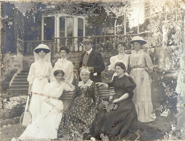
Series of Black & White Photos Total 8 Hill Family & Friends during the final years of World War I and into the touring boom of the 1920s. Lady dressed in all white, with dark coloured scarf over her shoulder, parasol in her right hand, in conversation with The Dean January 28th 1918.Oval photo of young girl dressed in dark skirt and white blouse in bush setting with trees in background, photo not very clear, 'Durvol' Kyneton 1918. Mollie & Babe Railway Reserve Kyneton, girl in light coloured dress reclining on the ground, other girl in kneeling position wears dark skirt and white blouse, palm tree to the left background, further back is paling fence, shrubbery to the right background, 1918. Horse & 4 wheeled Gig, man seated wears a dark suit with white shirt and dark tie, horse appears to be a grey colour, background shows bull nose veranda roof and part of a house gable, tree in framework on nature strip. Nell wearing a dark skirt and white top, right hand touching a shrub, white structure in the background, 'The Ranch' Eppalock November 1918. Botanical Gardens group photo, six young ladies, one wearing a vertical striped dress, three wear dark dresses with white blouses, two wear white blouses and dark skirts, one black hat and three light coloured, light hat in right foreground, January 1919. Jack & Mick in dark suits, white shirts, striped ties, shrubbery in the background, long trousers 'The Ranch' Eppalock January 14th 1917. two young ladies in all white, one holding a hat, young boy in dark clothing white shirt and dark tie, holding long stick, large shrub in the background, 'The Pines' Kyneton January 1919.Hilda Hill Personal Collectionaustralia, history, post war life -
 Bendigo Historical Society Inc.
Album - FORTUNA COLLECTION: ALBUM - PHOTOGRAPHS OF FORTUNA, BENDIGO
Fortuna Villa George Lansell purchased Ballerstadt's claim on Victoria Hill for £30,000. The purchase included a two-story villa. Lansell extended the building in the following years with the last major additions in 1904 - 1905. Architects included Vahland and Getzschmann, W.C. Vahland and William Beebe. Contractors include J.K. McLean and W.H.Johns.Album, covered in blue fabric. Printed in gold lettering on front 'Photographs of 'Fortuna' Bendigo". Album contains 48 black and white photos of George Lansell's home, Fortuna, taken in late 1800s, ranging from photos of the interior of the house, the garden and the lake.place, fortuna, photo album, george lansell, gold mining, ballerstedt, victoria hill, historic building -
 Eltham District Historical Society Inc
Negative - Photograph, J.A. McDonald, Kangaroo Ground-Queenstown Road, Aug. 1960
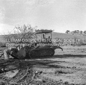
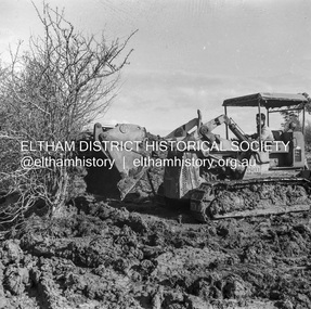
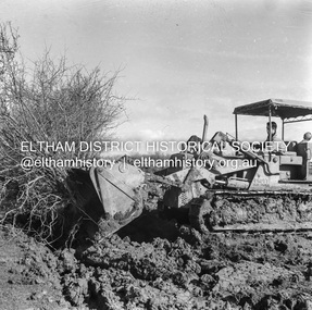
(Kangaroo Ground-St Andrews Road) “Rymers” Corner – shifting Hawthorn hedges on Tompkins property Council’s Drott 6 Woods Drott 9 August 1960 Showing hedge in rear already transported EDHS_05569-55 (EDHS_05577-3/4) and EDHS_05569-56 (EDHS_05577-5/6) - Hawthorn Hedges, Kangaroo Ground 50-50 ELTHAM, CUT THE HEDGES! While all of us are talking about the road toll, Eltham Council must have been in long recess. Around Kangaroo Ground are farmers’ hawthorn hedges shrouding dangerous corners on busy roads. If the council does not insist on their removal for a distance clear enough for safe driving, then it must be held culpable for the accidents that are bound to happen. – WAKE UP (Melbourne) ELTHAM, CUT THE HEDGES! 50-50 (1960, 6 January), The Sun (News clipping held in SEA_74-1_007) ‘BAD HEDGES’ WILL GO “We know there are some bad hedges on corners in the Kangaroo Ground area, but roadworks this year will eliminate them,” the Eltham Shire secretary, Mr Maxwell B. Watson, said yesterday. A reader in 50-50 yesterday complained of farmers’ hawthorn hedges obscuring drivers’ views at bad corners on busy roads in the Kangaroo Ground district. Mr Watson said the roadworks were deviations to remove the sharp turns, and the road would cut back into paddocks. The hedges would go at the same time. Meanwhile, the shire had power to require owners to cut back hedges, and this would be done if specific instances were reported and found justifiable. ‘BAD HEDGES’ WILL GO (1960, January 7), The Sun (News clipping held in SEA_74-1_007)Record of various Shire of Eltham infrastructure works undertaken during the period of 1952-1962 involving bridge and road reconstruction projects, sometimes with Eltham Shire Council Project Reference numbers quoted. It was during this period that a number of significant improvements were made to roads and new bridges constructed within the shire that remain in place as of present day (2022). In many situations, the photos provide a tangible visible record of infrastructure that existed throughout the early days of the Shire. The album was put together by or under the direction of the Shire Engineer, J.A. McDonald.infrastructure, shire of eltham, 1960-08, garden hill, kangaroo ground, kangaroo ground-queenstown road, kangaroo ground-st andrews road, rymers corner, bulldozer, drott -
 Eltham District Historical Society Inc
Negative - Photograph, J.A. McDonald, Kangaroo Ground-Queenstown Road, Aug. 1960
(Kangaroo Ground-St Andrews Road) “Rymers” Corner – shifting Hawthorn hedges on Tompkins property Council’s Drott 6 Woods Drott 9 August 1960 Showing method of lifting clumps of Hawthorn EDHS_05569-55 (EDHS_05577-3/4) and EDHS_05569-56 (EDHS_05577-5/6) - Hawthorn Hedges, Kangaroo Ground 50-50 ELTHAM, CUT THE HEDGES! While all of us are talking about the road toll, Eltham Council must have been in long recess. Around Kangaroo Ground are farmers’ hawthorn hedges shrouding dangerous corners on busy roads. If the council does not insist on their removal for a distance clear enough for safe driving, then it must be held culpable for the accidents that are bound to happen. – WAKE UP (Melbourne) ELTHAM, CUT THE HEDGES! 50-50 (1960, 6 January), The Sun (News clipping held in SEA_74-1_007) ‘BAD HEDGES’ WILL GO “We know there are some bad hedges on corners in the Kangaroo Ground area, but roadworks this year will eliminate them,” the Eltham Shire secretary, Mr Maxwell B. Watson, said yesterday. A reader in 50-50 yesterday complained of farmers’ hawthorn hedges obscuring drivers’ views at bad corners on busy roads in the Kangaroo Ground district. Mr Watson said the roadworks were deviations to remove the sharp turns, and the road would cut back into paddocks. The hedges would go at the same time. Meanwhile, the shire had power to require owners to cut back hedges, and this would be done if specific instances were reported and found justifiable. ‘BAD HEDGES’ WILL GO (1960, January 7), The Sun (News clipping held in SEA_74-1_007)Record of various Shire of Eltham infrastructure works undertaken during the period of 1952-1962 involving bridge and road reconstruction projects, sometimes with Eltham Shire Council Project Reference numbers quoted. It was during this period that a number of significant improvements were made to roads and new bridges constructed within the shire that remain in place as of present day (2022). In many situations, the photos provide a tangible visible record of infrastructure that existed throughout the early days of the Shire. The album was put together by or under the direction of the Shire Engineer, J.A. McDonald.infrastructure, shire of eltham, 1960-08, garden hill, kangaroo ground, kangaroo ground-queenstown road, kangaroo ground-st andrews road, rymers corner, bulldozer, drott -
 Eltham District Historical Society Inc
Negative - Photograph, J.A. McDonald, Kangaroo Ground-Queenstown Road, Aug. 1960
(Kangaroo Ground-St Andrews Road) “Rymers” Corner – shifting Hawthorn hedges on Tompkins property Council’s Drott 6 Woods Drott 9 August 1960 EDHS_05569-55 (EDHS_05577-3/4) and EDHS_05569-56 (EDHS_05577-5/6) - Hawthorn Hedges, Kangaroo Ground 50-50 ELTHAM, CUT THE HEDGES! While all of us are talking about the road toll, Eltham Council must have been in long recess. Around Kangaroo Ground are farmers’ hawthorn hedges shrouding dangerous corners on busy roads. If the council does not insist on their removal for a distance clear enough for safe driving, then it must be held culpable for the accidents that are bound to happen. – WAKE UP (Melbourne) ELTHAM, CUT THE HEDGES! 50-50 (1960, 6 January), The Sun (News clipping held in SEA_74-1_007) ‘BAD HEDGES’ WILL GO “We know there are some bad hedges on corners in the Kangaroo Ground area, but roadworks this year will eliminate them,” the Eltham Shire secretary, Mr Maxwell B. Watson, said yesterday. A reader in 50-50 yesterday complained of farmers’ hawthorn hedges obscuring drivers’ views at bad corners on busy roads in the Kangaroo Ground district. Mr Watson said the roadworks were deviations to remove the sharp turns, and the road would cut back into paddocks. The hedges would go at the same time. Meanwhile, the shire had power to require owners to cut back hedges, and this would be done if specific instances were reported and found justifiable. ‘BAD HEDGES’ WILL GO (1960, January 7), The Sun (News clipping held in SEA_74-1_007)Record of various Shire of Eltham infrastructure works undertaken during the period of 1952-1962 involving bridge and road reconstruction projects, sometimes with Eltham Shire Council Project Reference numbers quoted. It was during this period that a number of significant improvements were made to roads and new bridges constructed within the shire that remain in place as of present day (2022). In many situations, the photos provide a tangible visible record of infrastructure that existed throughout the early days of the Shire. The album was put together by or under the direction of the Shire Engineer, J.A. McDonald.infrastructure, shire of eltham, 1960-08, garden hill, kangaroo ground, kangaroo ground-queenstown road, kangaroo ground-st andrews road, rymers corner, bulldozer, drott -
 Sunbury Family History and Heritage Society Inc.
Photograph, 'Glenara' Homestead
'Glenara' is the homestead, which is situated in the Deep Creek valley at Bulla. It was the home of Walter Clark, who moved from NSW to Victoria in 1853 and purchased land on the banks of Deep Creek. Four years later in 1857 his homestead was completed. In the same year Bulla Racing Club held its first annual meet on the property. Later that year, Alister Clark purchased the homestead from the family estate and began developing an extensive rose garden on his property. Alister Clark developed varieties that are adaptable to Australia's climate such as the Lorraine Lee rose and his rose breeding achievements led him to international recognition as a rose breeder of note.A non-digital black and white photograph with a white border of large single story Italianite homestead in a creek valley and surrounded by lightly timbered hillsglenara homestead, bulla bulla, walter clark, alistair clark, roses, rose gardens, deep creek -
 Bendigo Historical Society Inc.
Photograph - T C WATTS & SON COLLECTION: BARKLY PLACE BENDIGO
BHS CollectionsBlack and white photograph mounted on rectangular grey board. House, brick and render, corrugated iron roof, large portico at front, wooden slat fence, lattice fernery LHS, 2 chimneys, adult male in front garden. House elevated, on hill. Barkly Place, Bendigo. Written on back of photoboard ' A. Cattram, Barkly Place, £1650'Frank A. Jeffree. Photo. Bendigobuilding, residential, barkly place bendigo, t.c. watts and son -
 Bendigo Historical Society Inc.
Photograph - THE EYRIE: QUARRY HILL, pre 1932
Black and white photo, 'The Eyrie' turretted and gabled roof line. Picket fence, brick pillars on gatewah with gravel path up on right to pine trees. Overgrown garden, with palm trees. On stick on label ' date unknown pre 1922 when steps were put in palms now well grown. Verandah canopy no longer striped wooden gates gone. House restored in 1998. To original colour scheme and verandahs now striped.buildings, residential, the eyrie -
Bendigo Historical Society Inc.
Document - MINING IN BENDIGO COLLECTION: LIST OF LEADING MINES
BHS CollectionHandwritten list of leading mines and dividend paying mines from the Annals 1889, 1890, 1891 and 1909 includes companies over 2000 feet on 31st March 1891.document, gold, mining in bendigo, mining in bendigo, list of leading mines, annals, great extended hustlers, catherine united, garden gully united, hercules & energetic, johnsons reef, lazarus no 1, new chum consolidated, north johnsons, north argus united, rose of denmark, shamrock, st mungo, specimen hill united hustlers & redan, united devonshire, watson's kentish, johnsons reef no 1, dixon's tribute, fortuna hustlers, lady barkly, lazarus, new chum railway, new red white & blue, north old chum, confidence, golden age, hustlers reef, new hopeful, new argus, new chum united, virginia, carlisle, catherine reef united tribs, collman & tacchi, goldfields consolidated, hercules & energetic tribs, horwood & burrowes, koch's pioneer, koch's pioneer tribs, new chum goldfields, new red white & blue tribs, new prince of wales, new prince of wales tribs, new moon, n bendigo, suffolk united, suffolk united tribs, south new moon, the langdon, victoria propty, victoria consols, victoria consols tribs, windmill hill, windmill hill tribs, lansells 180, north old chum, victoria quartz, victory & pandora, new chum & victoria, old chum, ironbark, shenandoah, lansell's 222, garibaldi, eureka, great central -
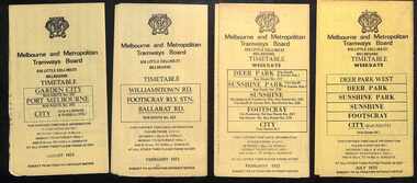 Melbourne Tram Museum
Ephemera - Timetables - MMTB Buses - set of 13, Melbourne & Metropolitan Tramways Board (MMTB), 1971 to 1973
Timetables - provide information on ticketing, fares, timing points, with a description of the route and a map. Not all services had been allocated a route number at the time. 1 - Garden City - Port Melbourne - City - routes 201, 202 - August 1972 2 - Williamstown Road - Footscray - Ballarat Rd - Route 223, Feb. 1972 3 - Deer Park, Sunshine Park, Sunshine, Footscray - City - routes 217, 219, 220, 229, 231 and 218 - Feb. 1972 4 - Deer Park West, Sunshine Park, Sunshine, Footscray - City - July 1973 5 - Fishermen's Bend - City - routes 233, 235 and 237 - March 1972 6 - Clifton Hill - Esternwick - Point Ormond - routes 246, 247 and 248 - August 1972 7 - Latrobe Uni - Northland - West Heidelberg - City - routes 256, 251, 253, 254, 252 and 255 August 1972 8 - East Kew, Box Hill, Doncaster, Shoppingtown - routes 284, 285 and 270 - July 1972 9 - Box Hill, Mitcham, East Doncaster, Ringwood - routes 287, 286, 288, 282, 283, and 272 - July 1972 10 - Box Hill - North Blackburn, route 290, printed on white paper - Sep. 1971 11 - Box Hill - Doncaster, Shoppingtown, Heidelberg, Templestowe, Serpells Rd and Lower Templestowe - routes 293, 296, 297, 271 - July 1972 12 Deer Park, Sunshine Park, Sunshine, Footscray - City - routes 217, 219, 220, 229, 231 and 218 - Saturdays and Sundays, printed on green paper - Feb. 1972 13 - Fishermans Bend - City - routes 233, 235 and 237 - June 1973 Yields information about MMTB Bus services during the 1970s. Set of twelve MMTB Bus timetables - multifolded printed on yellow paper, unless noted otherwise. timetable, mmtb, buses, port melbourne, garden city, williamstown rd, footscray, ballarat rd, sunshine, deer park, fisherman's bend, clifton hill, esternwick, point ormond, la trobe university, northland, west heidelberg, east kew, box hill, doncaster, shoppingtown, mitcham, ringwood, blackburn, templestowe, lower templestowe, fishermans bend -
 Bendigo Historical Society Inc.
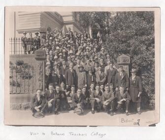
Photograph - LA TROBE UNIVERSITY BENDIGO COLLECTION: BENDIGO TEACHERS' COLLEGE
A black and white photograph of Bendigo Teachers' College students on a visit to Ballarat Teachers' College in 1927. The unnamed staff and students are seated at a main entrance with formal iron fence and pillars. In the foreground on the right is a garden and trees which are along the iron fence which runs up a hill to a fence and more garden the background. Also in the background is a building with ornate features. The men are all in suits with white collar and tie and some wear formal hats. The women are also in formal attire and most wear fashionable hats. See 3320.100bendigo, education, bendigo teachers' college, la trobe university bendigo collection, collection, bendigo, education, tertiary education, teacher training, photo, photograph, photographs, photography, ballarat teachers' college, bendigo teachers' college, costume, fashion, attire, clothing, history, miss j.c. burnett, mr. geoff. pryor, place -
 Federation University Historical Collection
Map, Ballaarat Gold Field, 1861, 21/10/1861
A party of surveyors camped by Yuille's Swamp (later Lake Wendouree) and surveyed the countryside for a map to be produced by the Geological Survey of Victoria. In November 2004 the Central Highlands Regional Library presented a special edition of 200 copies of the 1861 map reproduced from a copy in their collection. Original geological map of Ballarat showing property, waterways, mines, churches, schools, water races, and garden reserves. It was compiled and drawn from the surveys of Mining Surveyors Davidson, Fitzpatrick and Cowan.Compiled & Drawn from the Survey of Mining Surveyors Davidson, Fitzpatrick and Cowan & the Plans in the Surveyor General's Office by J. Brahe, 21st October 1861. R. Brough Smyth, Secretary for Mines. The Honourable J.B. Humffray, M.L.A. Commr of Mines.ballarat, map, davidson, robert brough-smyth, fitzpatrick, cowan, yuille's swamp, public garden reserve, manure depot, black hill, ballarat east, old post office hill, pennyweight hill, claytons hill, golden point, mining, railway, cricket ground, swamp creek, cemetery, sludge reserve, bakery hill, gaelic church, juvenile reformatory, orphanage, specimen hill, eureka lead, cattle yard hill, dalton's flat, chinese village, poverty hill, railway reserve, little bendigo diggings, pound reserve, allied armies, flour mill, agricultural reserve, marsh, survey reserve, survey corps, white flat, yarrowee, yarrowee creek, brache, j. brache, survey, ballaarat gold field 1861 -
 Bendigo Historical Society Inc.
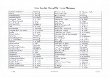
Document - MINING REPORTS - LIST OF LEGAL MANAGERS
Handwritten list by Albert Richardson, with typed copy of same, of some Bendigo Mines and their Legal Managers, as at September 30th, 1906. Document is part of the Albert Richardson Collection. document, gold, miner's right, mining reports, list of legal managers, j h craig, j h mccoll, g a petrie, h birch, b crofts, h y north, h kirkwood, s h mcgowan, g j keogh, c moore, w g blackham, w b walker, j humming, g h green, catherine reef united, carlisle, clarence united, central ellesmere, collman & tacchi, confidence extended, cornish united, daly & westons, don, ellenborough, extended southdevonshire, eureka, fortuna hustlers, fosterville, garden gully united, g g consolidated, garibaldi, great southern, great northern, great extended hustlers, great columbian, great central victoria, golden age, golden pyke, goldfields north, goldfields consolidated, hercules & energetic, hustlers reef, hustlers reef no 1, hustler's royal reserve, ironbark, johnson's reef, johnsons extended, koch's pioneer, lancashire, lazarus new chum, lady barkly, lightning hill, mcduff amalgamated, morning star, new chum consolidated, new chum railway, new chum & victoria, new red white & blue consolidated, new hopeful, new st mungo, new argus, new moon, new prince of wales, north lady brassey, new victoria catherine, new chum goldfields north new moon, north argus, north johnsons, pearl, princess dagmar, phoenix, railway prince of wales, shamrock, st mungo, sadowa, sea, stewart's united specimen's hill, south st mungo, south new moon, south devonshire, suffolk united, south prince of wales, spring gully junction, true blue, thomas united, united devonshire, unity, united hustlers & redan, united ulster, victoria consols, victoria reef quartz, victory and pandora, virginia, victoria proprietory, williams united -
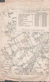 Bendigo Historical Society Inc.
Document - MINING REPORTS - MAP OF PART OF THE BENDIGO GOLDFIELD INCLUDING WHITE HILLS AND EAGLEHAWK
BHS CollectionMap of part of the Bendigo Goldfield including White Hills and Eaglehawk. Map shows reef lines, gullies, railway line, tram route, type of rock, name of mine, Calls and Dividends. Also Deepest Mine Victoria Quartz 4614 ft. Names of Mines are Garden Gully United, Great Ext'd Hustlers, Johnson's Reef, South New Moon, New Moon, Catherine Reef, Virginia, Central Red White & Blue, Ironbark, Kock's Pioneer, Carlisle and the Hercules & Energetic. Map is part of the Albert Richardson Collection of mining documents and research. document, gold, mining reports, mining reports, map of part of the bendigo goldfield including white hills and eaglehawk, pabst bendigo goldfield, garden gully united, great ext'd hustlers, johnson's reef, south new moon, new moon, catherine reef, virginia, central red white & blue, ironbark, kock's pioneer, carlisle, hercules & energetic. victoria quartz