Showing 3977 items
matching railway stations
-
 Otway Districts Historical Society
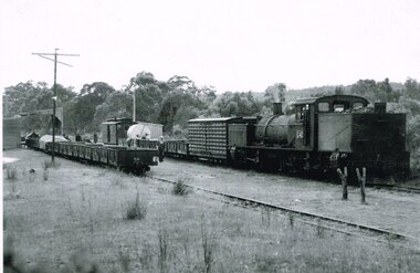
Photograph, R. Preston, Kawarren: Down goods with G42 shunting, 1955, 14 December 1955
Originally known as Loves River it became Kawarren station on 16 June 1902. It consisted of a loop siding and combined office and passenger shelter. Goods loading was sawn timber (brought in on four tramways operating between 1905 and 1939), firewood, charcoal and limestone. In 1920 the limestone company built a store shed and a covered loading area at the terminus to assist operations. The company also requested the siding to be extended by three metres, which Victorian Railways did in the same year. This gave the loop a capacity of 21 trucks. Around 2,000 tonnes per year of limestone traffic kept the station busy until trade ceased in 1957. A postal motor started in October 1938, Kawarren being a point where the postal motor and trains were permitted to cross.B/W. G42 with a Down goods train at Kawarren on 14 December 1955. On No.2 Road empty NQR wagons proceeding to get filled at a covered lime loading operation. A three workmen are checking aspects of the train while a group appear to be clustered at the guard's van around an NKS motor trolley.kawarren; railways; limestone; timber; charcoal; -
 Otway Districts Historical Society
Photograph, Gwen Armistead, Gellibrand: War Service Homes Commission Saw Mill, 1920, 1920
Four examples of saw mills placed in station yards were seen on the Beech Forest line of which one was the War Service Homes Commission weatherboard planning mill at Gellibrand. It operated between 1920 until 1923 for both inwards and outwards cartage of timber. As an alternative to Colac Reginald Driver, the WSHC operator, chose Gellibrand in September, 1920 as the site for a mill fitted with the latest double-bladed planning machine. The rough cut boards were sent by train from Driver's mills at Ferguson, Wyelangta and Macknott, off loaded at Gellibrand, and later reloaded for the trip to Colac.B/W. War Service Homes Commission Saw Mill at Gellibrand station in 1920. Six men loading palings onto a NQR wagon.gellibrand; war service homes commission; planing mill; railways;, gellibrand; war service homes commission; planing mill; railways; -
 Otway Districts Historical Society
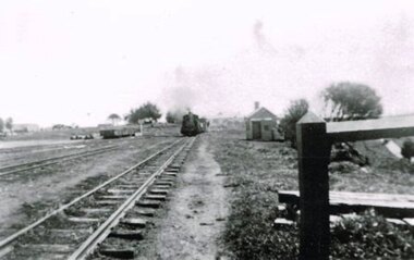
Photograph, Langford, Weston, Beech Forest: Goods trail departing for Colac, 1961, 9 August 1961
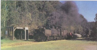
... Beech Forest Railway Station, Beech Forest, Otways ...The Garratts were approaching 35 years of age and needed constant repairs to keep them in service, the other rolling stock was between 45 and 60 years old, the track was generally in poor condition, and the amount of traffic offering was only a faction of that carried previously and came from one station, Beech Forest. A further sign of decay was in the transfer of goods between the gauges. Where eight or nine men had worked full-time transferring between gauges only one man was seen by 1960, with several other men hired on the basis of '$2 a truck', assuming they could be found. In 1961 VR announced its intention to close the line which it did on 30 June 1962. Colour. On 9 August 1961 a G42 locomotive and goods train departing for Colac with the coal stage on the left, the saw mill and Gangers Shed on the right, and houses in the right background.. beech forest; railways; -
 Otway Districts Historical Society
Photograph, Knox Collection, Beech Forest township, c.1903, c.1903
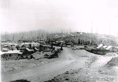
J.W. Gardner erected premises in Beech Forest which formed the core of a village. No further progress was made until access was facilitated though the development of a narrow gauge railway approved by the Victorian Parliament in 1898. Construction commenced in 1900. From this time Colac and Geelong business interests began investment in Beech Forest and established various retail and service establishments over the next few years. In 1902 three early settlers, Gardner, Charles Buchanan and John Cockerill, divided part of their land or bought land which was sold to businesses. On these subdivisions were created saleyards, general stores, a post office, bakery, blacksmithing, banks, a police station and lock-up, a public hall, churches, a state school, bootmaker, butcher, solicitor's office, hairdresser, billiard's saloon and newsagency.B/W. 188mm x 266mm. A general view of Beech Forest township in c.1903.beech forest; township; -
 Otway Districts Historical Society
Photograph, Brucker, Gellibrand station, 1922, 1922
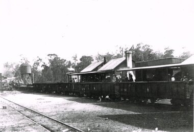
Gellibrand station became the railhead for traffic to the Carlisle River and Lardners, as well as the centre of timber and fruit trade. Outward loading was substantial at the time the photograph was taken. Sawn and split timber, firewood, sleepers and piles were loaded in large quantities. The general expansion in traffic led in October 1923 to the laying of an additional loop siding and provision for a goods shed., B/W. In 1922, Gellibrand station with passengers and workmen on the station concourse, and NQR wagons aligned ready to move. Note the water tank on the left and the start of the Refreshment Room on the right.gellibrand; railways; -
 Otway Districts Historical Society
Photograph, R. Preston, Kawarren: an UP goods train, 1958, 14 December 1958
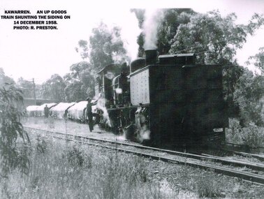
Kawarren was an early timber and limestone loading point. Timber was shipped in by Watson and Facey, Condon Brothers, and Coppock, amongst others, some of which had tramways up to 6.5 km long to the station. Bushfires roared through the area in 1939 and made the area unworkable. An outcrop of limestone existed near Kawarren but it was not until the railway was built that it became workable. 360 metres north of Kawarren station two then three kilns were erected, and later a shed and covered area over a short length of the rail siding in order to prevent rain damage to the lime while it was being loaded. Sluicing was introduced, and the tramway was extended further when the quarry ate deeper into the hillside. Limestone traffic of around 2,000 tonnes each year kept the station busy until the trade ceased in 1957.B/W. On the 14 December 1958 at Kawarren an UP goods train shunts on the siding. A man is talking to the engine driver while another man approaches the engine.kawarren; railways; timber; lime; -
 Otway Districts Historical Society
Photograph, R. Preston, Taking water at Wimba tank, 8 January 1958
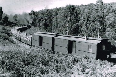
Wimba station is 37.3 km south of Colac. This station, originally called "Bunding", opened with the line in in March, 1902, as an unnamed stopping place. It was renamed "Wimba" on 17 November, 1902. A water tank for locomotive requirements was placed on the side of a hill about 100 metres south of the station. Wimba was not provided with a loop siding but had a passenger shelter until 1936 when the roads took over. A sheep race was provided near the passenger shelter. The station closed with the line.B/W. An UP goods train loaded with pulp wood on NQR wagons and two NC guard's vans taking water at Wimba tank on 8 January 1958. wimba; railways; -
 Otway Districts Historical Society
Photograph, Brucker, Beech Forest: Locomotive 5A during construction, c.1902, c.1902
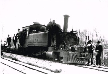
In 1898 a recommendation for a railway of 2 ft 6 in gauge was handed down by the Parliamentary Standing Committee on Railways, to cost $138,000. Construction began in 1900. About 100 men were engaged in laying and ballasting the track while others, not included in the 100, formed the earthworks, culverts and bridges. Locomotive operations initially were two 2-6-2 Tank engines of the narrow gauge A class, dubbed "Coffee Pots", and these were used on the work trains between 1900 and 1902. Because of the lengthy periods of waiting time required to unload sleepers and rails or to load ballast meant that a handy replenishment of coal and water supply was necessary. With earthworks specified to the bare minimum landslips in the narrow cuttings were frequent so a repairer was stationed in each length to deal quickly with minor slips until 1904 when the cuttings were widened.B/W. The driver and seven other men on locomotive 5A and its flat cars at Beech Forest during construction of the line in c.1902. beech forest; railways; loco 5a; -
 Otway Districts Historical Society
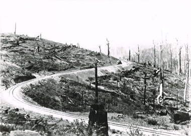
Photograph, Victorian Railways, Bend 21.5 miles looking south, 1901
Banool station is 34.1 km down the railway line from Colac: this photograph was taken 34.6 km down the line, half a kilometre onwards.B/W. A bend in the line 21.5 miles (34.6 km) looking south.banool; beech forest; railways; -
 Otway Districts Historical Society
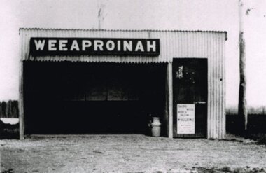
Photograph, R. Preston, Weeaproinah mallee shed, c.1920, c.1920
Originally named 'McInnes' after a local selector, this station opened during construction of the Crowes railway on 1 May 1911. The name was altered to Weeaproinah, the second station of that name, on 9 December 1912, after the parish in which the station was situated. (The original 'Weeaproinah' on the railway became earlier 'Dinmont' in the Olangolah Parish.) The station comprised a passenger shelter and a loop siding with a ramped platform for a sheep and pig race. A departmental residence was built for a track repairer based at the station, but no station or caretaker staff were employed there. The residence was burnt down during the 1919 bushfire but it was replaced and remained in use as a departmental residence until 1930. Weeaproinah became an unattended crossing station in December 1927 under the Train Section Order system.B/W. Weeaproinah mallee shed. In the shed there are five large wall-mounted posters and a cream can. An unlocked door with a "Skins / Hides" poster gives access the inside. A tree trunk stands to the right.weeaproinah; railways; shed; -
 Otway Districts Historical Society
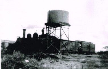
Photograph, R. Preston, Wimba Tank Stand, c.1960, c.1960
Wimba station opened with the line in March 1902 as an unnamed stopping place, and a water tank for locomotive requirements was placed on the side of a hill about 100 metres south of the station. Locos bound for Beech Forest stopped at the passenger shelter at the station, uncoupled, and moved forward to the water tank. Goods were loaded and unloaded during this pause. The station and the tank closed with the line.B/W. Engine 14A, an NUU louvre van and an NC guard's van at the Wimba Tank, with fireman L. Moore on the roof of the cabin running water into the engine's tank. The guard returns to his van.wimba; railways; water tank; -
 Otway Districts Historical Society
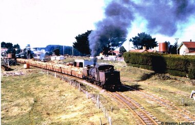
Photograph, R. Preston, Banool: Locomotive G42 and goods, c.1960, c.1960
This original station on the Colac-Beech Forest line was first known as "Moorbanool" after the local parish, and then shortened to "Banool" on 1 November 1904. At first facilities consisted of a passenger shelter, a loop siding for 11 trucks, plus a residence for the ganger of the track gang based there. By 1912 with the extension of the line to Crowes increased train services on the line required a crossing station in this section of the track, and therefore Banool became a staff and ticket station with a crossing loop and home signals. However, this only lasted for two years and was abolished as an economy measure in 1916. Loading figures show that in most years the outwards tonnage at Banool was less than 150 tonnes. The station was reduced to a passenger shelter and goods loop only by 1929, and by the time of closure in 1962 most trains were steaming through.Colour. Locomotive G42 and its NQR goods wagons, loaded and unloaded, steaming past Banool station passenger shelter. 143mm x 274mm print.banool; moorbanool; railways; locomotive g42; -
 Otway Districts Historical Society
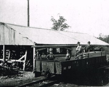
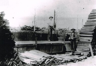
Photograph, R. Preston, Beech Forest: Loading puncheons, c.1914, c.1914
While one of the lesser prime loading points sawn and split timber were loaded at Beech Forest, and a large share of this was brought to the station over two timber tramways that operated between 1904 and 1933. At the eastern end of the railway yard, near the six-ton derrick crane, a wooden tramline curved out the gate and along the road for about 8 km (5 miles) to the co-operative Box Company, known locally as the Box mill, owned by the Victorian Diary Farmers' Co-operative whose purpose was the milling of butter boxes. Other millers also provided timber. Logs were hauled to the mill by horses, and the sawn timber despatched over a tramline that joined the Box mill line about 1.2 km (0.75 miles) along. B/W. Two men loading puncheons (a short post approximately 4 feet [1.2 metres] especially used for supporting a roof in a coal mine) on a NQR wagon at Beech Forest. Note the lack of trees in the background.beech forest; railways; puncheons; -
 Otway Districts Historical Society
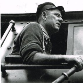
Photograph, Kevin L Holmes, Driver Bill Brady with Train Staff, 1961, 1961
Railway systems have methods by which trains can proceed in safety from station to station, free from the risk of collision with other trains. These methods are generally known as "Safeworking" and they particularly apply to trains on single lines where trains run in opposite directions. The stations between these two sections are called crossing stations. A "Train Staff", a thick, round metal rod, bearing the name of the two stations is issued and these places are designated as Train Staff stations. No train is permitted to proceed through the section unless the train driver either takes the staff for the section into his possession or personally sights the staff. (Note that every station on the line is not a crossing station. These roles were performed at Barongarook, Gellibrand, Banool, Beech Forest, Wyelangta, Weeaproinah and Crowes.) Except for the period 1927-1939 when Train Section Orders were applied instead, due to declining business Train Staff and Ticket working was used throughout on the line.B/W. Driver Bill Brady holding the Train Staff in the cabin of Garratt locomotive G42, at Weeaproinah 1961 railways, bill brady, train driver, weeaproinah, train staff -
 Otway Districts Historical Society
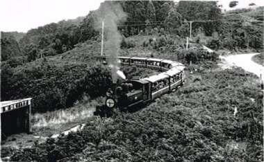
Photograph, R. Preston, McDevitt: Loco 14A passes through, 21 March 1959
In February 1959 eight NBH carriages were tranfered from storage at Newport to Colac in time for the first tentatively organized trip over the Colac-Beech Forest railway line. Eventually seventeen excursion trains ran, with carriages and an NC guard's van, usually hauled by G41 or G42, but occasionally 14A locomotive. The train run by 14A ran soon after the carriages were delivered.B/W. At McDevitt station locomotive 14A passes through on a rare NA-hauled eight excursion carriage and NC guard's van train. The front of the engine is labelled "The Ridge; 21 M(arch) 1959; ARHS", the Australian Railways Historical Society.colac; beech forest; railways; mcdevitt; -
 Otway Districts Historical Society
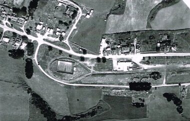
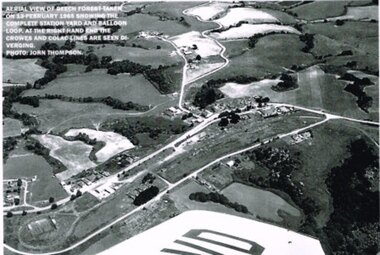
Photograph, R. Preston, Aerial view of Beech Forest railway station and yards, 1965, 13 February 1965
... Aerial view of Beech Forest railway station and yards, 1965.... Forest great-ocean-road beech forest: railways; township; aerial ...B/W. An aerial view of Beech Forest showing the balloon loop at the end of the station yard (enclosing the two tennis courts), two ex-departmental residences, the station buildings, and other aspects of the township.beech forest: railways; township; aerial; -
 Otway Districts Historical Society
Photograph, R. Preston, Aerial view: Beech Forest, 1965, 13 February 1965
B/W. Aerial view of Beech Forest showing the complete station yard including the balloon loop (incorporating the two tennis courts), two ex-departmental residences, the station building and where the Colac and Crowes lines diverged. As well Beech Forest Hall, council offices and Shire Secretary's house, Denherts Track, and Main Road are shown.beech forest; railways; township; aerial; -
 Otway Districts Historical Society
Photograph - Black and white photograph, Irene Zappelli Collection, empty, c. 1900
... Forest great-ocean-road beech forest train wagon railway tracks ...B/W. Tracks 1 to 4 at Beech Forest, an NA-class locomotive and goods on No.1, an NQR wagon on No.4, and a station building in the right, in the early 1900s. 167mm x 280mm print.beech forest, train, wagon, railway, tracks, train station -
 Otway Districts Historical Society
Photograph, Crowes: Terminus of the railway line, 1911
The terminus of the railway, and the southern-most station on the Australian mainland, was Crowes, approximately 2 kilometres from Lavers Hill. The line ended at "The Black Stump". Crowes was designed as a fully functioning terminus and received a complete instalment of facilities. The site was laid out with three roads plus a dead end siding for a locomotive shed and ash pit. Goods sheds, a platform and livestock ramps catered for freight loadings, while on the north side was a station office, waiting room, parcels shed and passenger shelter. Three departmental residences were also provided. The resident Station Master was withdrawn in November 1916 and the station closed with the line on 10 December 1954.Photograph. Terminus of the Colac-Crowes at Crowes.crowes; terminus; "the black stump"; -
 Bendigo Historical Society Inc.
Photograph - BENDIGO RAILWAY STATION: STEAM TRAIN OUTSIDE GOODS SHED
... BENDIGO RAILWAY STATION: STEAM TRAIN OUTSIDE GOODS SHED... arched windows. Photograph BENDIGO RAILWAY STATION: STEAM TRAIN ...Photocopy of photo: image shows steam engine and tender on line outside goods shed at rear. Shed is red brick, white brick pointing, semi arched windows.railways, bendigo to melbourne, bendigo steam train -
 Bendigo Historical Society Inc.
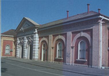
Photograph - BENDIGO RAILWAY STATION PLATFORM NO 2 BUILDING
... BENDIGO RAILWAY STATION PLATFORM NO 2 BUILDING... of 1965. Photograph BENDIGO RAILWAY STATION PLATFORM NO 2 BUILDING ...Colour image, laminated, shows brick building, arched windows, double doorway, pediment on top of entry. On back of photo : Platform Number 2, what the original platform number 1 was like before the fire of 1965.railways, bendigo to melbourne, platform number 2 -
 Bendigo Historical Society Inc.
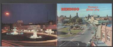
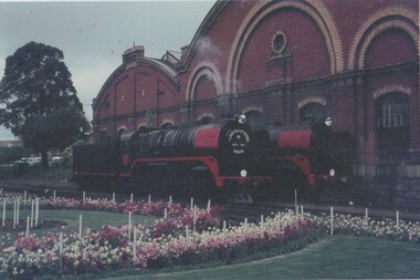
Book - BENDIGO: VICTORIA'S GOLDEN CITY
... Bendigo Railway Station... & Co Coach R Class Locomotive Bendigo Railway Station Bendigo ...Coloured booklet of various scenes and buildings in and around Bendigo, titled Bendigo Victoria's Golden City. The front cover has a scene of Charing Cross looking towards Pall Mall. Inside the front cover is a very brief history and some Historical Buildings are mentioned. They are: Fortuna, Shamrock Hotel, Gold Mines Hotel, City Hall, Post Office, Law Courts, the Home for the Aged, Sacred Heart Cathedral, St. Paul's, Specimen Cottage, Log Lock-up and the Chinese Joss House. The coloured pictures inside are: The Central Deborah Gold Mine, Fortuna, Miner's Cottage, The Gold Mines Hotel, Victoria Hill, Bendigo Law Courts, Eaglehawk Log Lock-up, Look-out Tower Rosalind Park, Alexandra Fountain - Charing Cross, Conservatory Gardens with Law Courts in background, Inside the Conservatory, Bendigo Home & Hospital for the Aged - Victoria's 'White House', Sacred Heart Cathedral, Chinese Joss House, Chinese Joss House - Interior of the Main Temple, Bendigo Pottery - Potter at work, Bendigo Municipal Offices, Bendigo Institute of Technology at Flora Hill, Mt. Alvernia Hospital, Cobb & Co Coach, R Class Locomotive, Bendigo Tramcar, Lake Weeroona and Lake Eppalock Pumping Station. Some more attractions are mentioned inside the back cover. On the back cover is the Cenotaph - the only scale replica of the Whitehall Cenotaph - and Alexandra Fountain by night.Nucolorvue Productions Pty Ltdbendigo, tourism, photographs of bendigo icons, bendigo - victoria's golden city, fortuna, shamrock hotel, gold mines hotel, city hall, post office, law courts, home for the aged, victoria's 'white house', sacred heart cathedral, st paul's, specimen cottage, log lock-up, chinese joss house, charing cross, cenotaph, alexandra fountain, centra deborah gold mine, army cartographic unit, miner's cottage, harvey town, victoria hill, look-out tower rosalind park, conservatory gardens, conservatory, bendigo pottery, bendigo municipal offices, bendigo institute of technology, mt alvernia hospital, cobb & co coach, r class locomotive, bendigo railway station, bendigo tramcar, lake weeroona, lake eppalock pumping station, art gallery, historical museum eaglehawk, melville's caves, whitehall cenotaph, nucolorvue productins pty ltd, national library of australia -
 Bayside Gallery - Bayside City Council Art & Heritage Collection
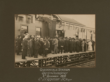
Photograph - sepia photograph, Sears Studios, Opening of Gardenvale Station, 1906
... mayor sears studios railway gardenvale station Opening ...gardenvale, station, train, platform, public transport, opening, crowd, mayor, sears studios, railway, gardenvale station -
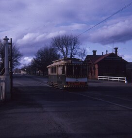
 Ballarat Tramway Museum
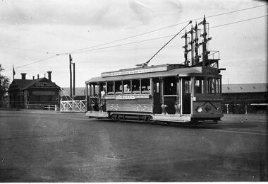
Negative, Wal Jack, 1951
... Ballarat Railway Station... Ballarat Railway Station Gold Tram tram 23 Negative and Digital ...Yields information about the Gold tram of 1951 and of the railway level crossing in Lydiard St North.Negative and Digital image of the Wal Jack Ballarat Negative file of No. 23 as the gold tram crossing the level crossing in Lydiard St North, during 1951 on its way to Lydiard St North. In the background is the signal gantry and the Kennedy Murray Pty Ltd General Carriers. trams, tramways, lydiard st nth, level crossings, ballarat railway station, gold tram, tram 23 -
 Ballarat Tramway Museum
Slide - 27 mm sq slide/s, Andrew Howlett, Tram No. 27, southbound crossing the Lydiard St level crossing, Sep. 1968
... Railway Station... Nth Level Crossings Railway Station tram 27 "Railway Xing ...Yields information about the Lydiard St Nth Level crossing.Colour slide, Kodak white cardboard mount, developed September 1968 of No. 27, southbound crossing the Lydiard St level crossing with a destination of Sebastopol. The tram has a Twin Lakes sign. the Kennedy Murrays General Carrier building in the background."Railway Xing Lydiard St Nth" in red ink.ballarat, tramways, trams, lydiard st nth, level crossings, railway station, tram 27 -
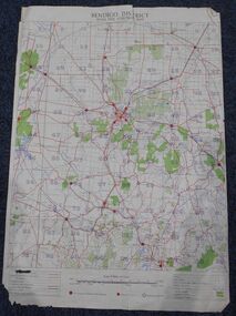 Bendigo Historical Society Inc.
Map - Bush Fire Control Map Bendigo District
A Bush Fire Control map is a valuable tool used by emergency services and communities to respond to respond to bushfires.Cream coloured parchment map showing roads, railway lines, telephone lines, rivers, creeks and water courses. Also marked are houses, Post Offices, Police stations, bush fire brigades, water channels, swamps, marshes, dense, medium and scattered timber, aqueducts and reservoirs. Villages, districts and Towns are clearly marked. Printed in red, green, black and blue. Very clear and easy to read. Undated.bush fires, bendigo area map -
 Bendigo Historical Society Inc.
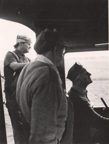
Photograph - RAILWAY COLLECTION: TWO PHOTOGRAPHS OF R761 RUN BENDIGO TO MELBOURNE
... B R761 gathering steam at Bendigo Station Photograph RAILWAY ...Two photographs of for a trial record run Bendigo to Melbourne (undated) on retirement of R761 engine A three railway staff in R761 engine cabin B R761 gathering steam at Bendigo Station -
 Bendigo Historical Society Inc.
Photograph - RAILWAY COLLECTION: VARIOUS PHOTOS OF BENDIGO LOCOMOTIVE YARD AND STATION, 1969
Various photographs of Benigo Railway Locomotive yard and staff A Bendigo locomotive yard and two engines B 1959 Bendigo Workshops cricket match,I Fisher batting C Waly Meagher, Dimmy Muldoon & Ned Breaton D Arthur Eaton, Acting Manaager Bendigo North Railways Workshop (taken between Sept & Dec 1969 -
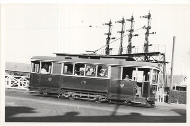 Ballarat Tramway Museum
Photograph - Black & White - Tram 20 at Railway level crossing, Keith Kings, 22/1/1955
... railway station... north level crossing railway station tram 20 On rear has ...Shows trams at the Lydiard St level crossing gates and the signal gantry.Yields information about Ballarat tram No. 20 and the locationBlack and White photograph of SEC Ballarat tram No. 20 crossing the railway level crossing in Lydiard St North. Has the signal gantry in the background. Photo by Keith Kings 22/1/1955.On rear has the photographers file number (M)(d)(3)ballarat, lydiard st north, level crossing, railway station, tram 20 -
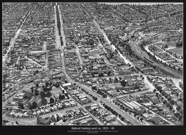 Ballarat Tramway Museum
Photograph - Black & White copy, Charles Pratt, "Ballarat looking west ca 1925-40"
... East and views across over the Railway Station to Lake ...Original photograph by Charles Daniel Pratt, with the original image held by the State Library of Victoria. Edited by Richard Conn. Purchased by the Museum.Provides information about the appearance of Ballarat East and views across over the Railway Station to Lake Wendouree and along along Sturt St. Shows the nature of the Bridge St shopping centre and other places.Black & White copy photograph aerial view A4 size, titled "Ballarat looking west ca 1925-40" - looking along Sturt St with the Railway yards, Bridge St and Victoria St in the view. Some trams can be seen at Grenville St.ballarat, aerial photo, sturt st, victoria st