Showing 10936 items matching " land"
-
 Tatura Irrigation & Wartime Camps Museum
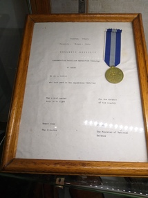
Certificate - Certificate of Gratitude, Certificate of Gratitude to Mr A Ransom
The certificate of gratitude was present to Mr A Ransom by the Greek Government. It was awarded to Australian servicemen who served in Greece against overwhelming number of German air and land troops.Piece of white paper with black writing, enclosed in a brown wooden frame. Attached to document is a bronze medal with a stripped ribbon. One band of navy blue, one band of light blue and one band of navy blue.certificate of gratitude, mr a ransom, greek government, australian servicemen, greece, german air and land troops -
 Katandra and District History Group
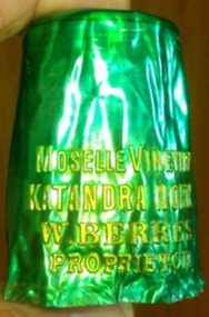
A Wine Bottle Cover, early 20th century
W. Berres winery located at Katandra North early 20th century .The land was later taken over by Vic. government for soldier settlement.This is a small remenant of the winery.Wine bottle cap cover green with gold letteringmoselle vineyard katandra north w berres proprietorw.berres vineyard -
 Whitehorse Historical Society Inc.
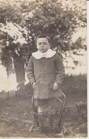
Photograph, James Hansen, 1916
James Hansen was adopted by Francesca and Louis Schwerkolt. When Francesca died she left him two blocks of land and a house in Deep Creek Road Mitcham.Black & white photograph of James Hansen, fostered son of Francesca Schwerkolt. He is standing on a chair, is dressed in a coat and short pants and is wearing a white collar.Jimmy Hansen c1916hansen james, schwerkolt francesca -
 Kew Historical Society Inc
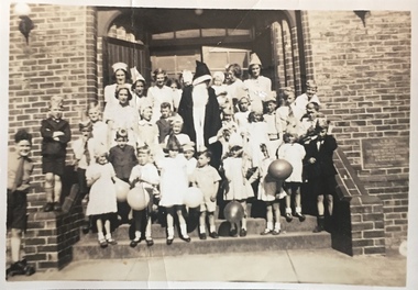
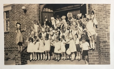
Photograph - St Hilary's Church Christmas Party, c.1932
St Hilary's Anglican Church in Kew was established in 1888 on land granted to the congregation by the Dumaresq family. The brick building shown here replaced an earlier wooden structure.Small black and white photographic positive, one of four, of a Christmas party for children at St Hilary's Church, 12 John Street, Kew. The children, surrounding an adult Santa Claus, are dressed in festive costumes and a number carry balloons. The foundation plaque is on the wall to the children's left. The photo was tentatively dated to 1932 by the donor. Inscribed verso: "St Hilary's Christmas Party ?1932"churches -- kew (vic.), st hilary's church -- kew, anglican churches -- melbourne (vic.) -
 Kew Historical Society Inc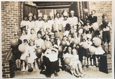
Photograph - St Hilary's Church Christmas Party, c.1932
St Hilary's Anglican Church in Kew was established in 1888 on land granted to the congregation by the Dumaresq family. The brick building shown here replaced an earlier wooden structure.Small black and white photographic positive, one of four, of a Christmas party for children at St Hilary's Church, 12 John Street, Kew. The children, surrounding an adult Santa Claus, are dressed in festive costumes and a number carry balloons. The photo was tentatively dated to 1932 by the donor. Inscribed verso: "St Hilary's Christmas Party ?1932"churches -- kew (vic.), st hilary's church -- kew, anglican churches -- melbourne (vic.) -
 Kew Historical Society Inc
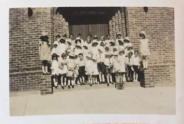
Photograph - St Hilary's Church Christmas Party, c.1932
St Hilary's Anglican Church in Kew was established in 1888 on land granted to the congregation by the Dumaresq family. The brick building shown here replaced an earlier wooden structure.Small black and white photographic positive, one of four, of a Christmas party for children at St Hilary's Church, 12 John Street, Kew. The children are formally dressed with most wearing hats. The photo was tentatively dated to 1932 by the donor. Inscribed verso: "1932 St Hilary's Christmas Party"churches -- kew (vic.), st hilary's church -- kew, anglican churches -- melbourne (vic.) -
 City of Kingston
Pamphlet - Colour, Stillwell and Co, The Hill Estate Highett Great Subdivisional Auction Sale, 1917
Sales plan for land in the suburb of Highett, bounded by Point Nepean Road and incorporating Sandford Street, Turner Road, Alfred Street, Peace Street and Tennyson Street. .The developing urban area of Highett within the City of Kingston. This land sale pamphlet illustrates the subdivision of land within the municipality and the changing demographic of the district as new houses are constructed.Colour pamphlet advertising subdivisional auction sale of the Hill Estate Highett. Incorporates a map of the estate bordered by Point Nepean Road and encompassing Sandford Street, Turner Road, Alfred Street, Peace Street and Tennyson St. Handwritten in grey pencil on reverse: Hill Street / Jamieson Handwritten in blue pencil on reverse: The Hill Estate Handwritten in blue pencil on subdivision map: [tick] [on majority of properties marked on map]highett, land sales, estate -
 City of Kingston
Pamphlet - Colour, W. H. Wood Estate Agent, Realising sub-divisional auction sale Bentleigh Park Estate, Bentleigh, 1920
Sales plan for land in the suburb of Bentleigh, bounded by Centre Road, and incorporating subdivisions on either side of Elizabeth Street (Wheatley Road), Oak Street and Beech Street.The developing urban area of Bentleigh within the City of Kingston. This land sale pamphlet illustrates the subdivision of land within the municipality and the changing demographic of the district as new houses are constructed close to infrastructure.Colour pamphlet advertising a realising sub-divisional auction sale of the Bentleigh Park Estate, Bentleigh. Incorporates a map of the estate bordered by Centre Road, and including Elizabeth Street (Wheatley Road), Oak Street and Beech Street.Hand drawn in grey pencil: a small square on subdivision 33 Hand drawn in grey pencil: a small square incorporating a cross on subdivision 24 Hand written in black ink on reverse: Bentleigh Park / Estate / Ward late Andersonsland sales, estate, bentleigh -
 Whitehorse Historical Society Inc.
Photograph - Black and white Digital Copy, Wandinong Sanctuary
The house and land on the corner of Canterbury Road and Ronley Street Blackburn was donated to Nunawading Council by Janet and Arthur Hooke upon their deaths as a permanent bush area for the public.Two digital copies of a function at Wandinong Blackburn.janet hooke, arthur hooke, wandinong sanctuary -
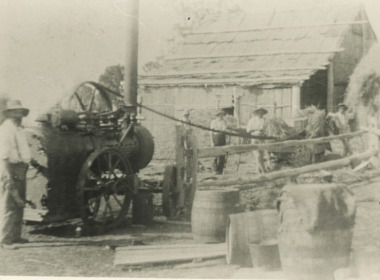 Lakes Entrance Historical Society
Photograph - Hay Baling, Steam engine baler, East Gippsland, 1915 c
Shed behind workers in clad and roofed with bark sheets held in place with horizontal timbers. The contractor with steam engine travelled around the district as requested by land ownersBlack and white photograph of five workers baling hay using small steam engine to power the baler on a farm in East Gippslandagriculture, steam engine -
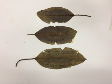 Kew Historical Society Inc
Plant specimen, Dorothy Rogers, Inscribed Moreton Bay Fig Leaves, Hawthorn (Vic), c.1960s
Collected by the historian Dorothy RogersDried Moreton Bay fig leaves from the vicinity of Palmer's Punt near Denham Street Hawthorn. Each leaf was inscribed by the historian Dorothy Rogers (sic) before 1973. The leaves are brittle and undated, with the text difficult to decipher. 1974.0010.1 "Moreton Bay fig leaf from old tree foot of Derham St Haw - vicinity Palmer's Punt until 1934 flood & hut for Punt passengers was still there. KH-355." 1974.0010.2 "Moreton Bay fig leaf from old tree foot of Denham St haw - vicinity Palmer's Punt until 1934 flood hut for punt passengers still existed there. A canoe tree in garden from Sir J. Palmer's land. KH-355." 1974.0010.3 "Moreton Bay fig leaf from old tree foot of Denham St leading to Palmer's Punt until 1934 flood there was still there a hut for punt passengers. Canoe tree in gardens from Sir J. Palmer's land. KH-355."denham street - hawthorn (vic), palmer's punt, invergowrie - hawthorn, 1934 flood - melbourne - hawthorn (vic) -
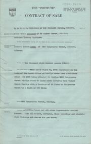 Bendigo Historical Society Inc.
Document - H. A. & S. R. WILKINSOM COLLECTION: CONTRACT OF SALE
Contract of sale dated 28th November between Mr. E. S. Harrison (vendor) and Mr. L. J. Tuena. Solicitor for vendor: E. S. Cahill & son View Street, Bendigo. Solicitor for purchaser: H. E. Every, Dispensatory Walk, Bendigo. Property: 529 Hargreaves Street, Bendigo being land held under right No. 4703 registered in the books of the lands office at Bendigo under land 9residence areas) act 1955 being situated in section 139C Hargreaves Street, Bendigo about 69 links north easterly from Violet Street Bendigo with a frontage of 50 links to Hargreaves Street by a depth of 200 links, together with dwelling house and all improvements, also all blinds, curtains, floor coverings and electric light fittings and shades and gas stove. Price: 1,600 pounds. Attached: statement pursuant to section 34 and engagement or appointment in writing pursuant to section 33 of the estate agents act, 1956.organization, business, h.a. & s.r wilkinson real estate -
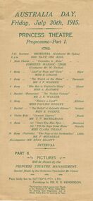 Bendigo Historical Society Inc.
Document - ROYAL PRINCESS THEATRE COLLECTION: AUSTRALIA DAY 1915 PROGRAMME, 30 July 1915
Princess Theatre, Australia Day, Friday, July 30th, 1915. Programme - Part 1. 'Comrades in Arms', Combined Masonic Choir. Land of hope and Glory, Miss E Linane. The Watch on the Rhine, Mr J F Warren. The Sea is England's Glory, Miss A Macoboy. The Yankee Colonel, Mr J K Wlker. There's a Land, Miss Pauline Bindley. The Ballad of Splendid Silence, Miss E O'Keefe. Concert Caprice, Mr T P Bockelmann. Open Thy Blue Eyes, 'Till the Boys Come Home, Miss Clara Colgan. The Boys of Dardanelles, Mr F Monaghan. Accompanist-Mr Stan Elliot. Part II. Pictures will be shown by the Princess Theatre Management. Special Music by the Orchestra (Conductor Mr Upton). Piano kindly lent by Sutton's PTY LTD. Furnishings by Mr R O Henderson. The Committee wish to express their thanks to the Employees of of Messrs. Bolton Bros. for Printing these Programs, and to Messrs. Bolton Bros. for supplying the Paper.Bolton Brosprogram, music, princess theatre, princess theatre, australia day, july 30th, 1915. programme - part 1. 'comrades in arms', combined masonic choir. land of hope and glory, miss e linane. the watch on the rhine, mr j f warren. the sea is england's glory, miss a macoboy. the yankee colonel, mr j k wlker. there's a land, miss pauline bindley. the ballad of splendid silence, miss e o'keefe. concert caprice, mr t p bockelmann. open thy blue eyes, 'till the boys come home, miss clara colgan. the boys of dardanelles, mr f monaghan. accompanist-mr stan elliot. part ii. pictures will be shown by the princess theatre management. special music by the orchestra (conductor mr upton). piano kindly lent by sutton's pty ltd. furnishings by mr r o henderson. the committee wish to express their thanks to the employees of of messrs. bolton bros. for printing and paper -
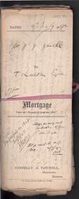 Bendigo Historical Society Inc.
Document - CONNELLY, TATCHELL, DUNLOP COLLECTION: MORTGAGE MR. J.J. JEWELL TO T. LUXTON ESQ
Documents relating to mortgage between Mr. Joshua James Jewell of Mitiamo, farmer, and Mr. T. Luxton , The Exchange, Collins St., Melbourne for land at Parish of Terrick Terrick West, County of Gunbower, mortgage document dated 4th. July 1892. Contains 3 Conditions of Sale documents, newspaper clipping re clearing sale of 2600 acres of land on behalf of Mr. J.J. Jewell, farming implements, machinery, household effects at 'The Hill' Mitiamo.. Letters relating to transactions re above mortgage enclosed, including discharge of mortgage handwritten document between Sarah Berges and Joshua J. Jewell. Note name change from Connelly & Tatchell, to Connelly, Tatchell & Paling. Letter enclosed in file from Mr. Joshua Jewell, 'The Hill' Mitiamo, Oct 4th., 1893 to Mr. T, Luxton, requesting ' waiting another (?) for money I will be able to pay it before the month is up but at present I cannot meet it. I have just commenced to shear and of course money will be coming in now'cottage, miners, joshua james jewell, thomas luxton, terrick terrick west, gunbower, mortgage, connelly, tatchell & paling, s. berges, connelly, tatchell & dunlop, paling. -
 Eltham District Historical Society Inc
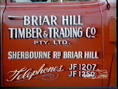
Film - Video (DVD), H.V. Plowman, Briar Hill Timber & Trading Co. Pty. Ltd, c.1956
Briar Hill Timber was associated with the Olympic Village Project being suppliers of all building materials including Flush Panel Doors, Mouldings and Joinery. Briar Hill Timber owned by F. Squire and the Squire family owned a lot of land around Briar Hill and land for forest at Flowerdale. The 16 mm film photographed by H.V. Plowman (converted to DVD) shows all aspects of the operations of Briar Hill Timber from logging of trees, to milling to manufacture of joinery and housing framesMP4 00:13:12; 247MB Converted from DVD converted from VHS video converted from 16mm colour filmbriar hill timber, f. squire, olympic village, 1956 olympic games, timber mill, flowerdale, cinematography, briar hill, h.v. plowman, logging, video recording -
 Orbost & District Historical Society
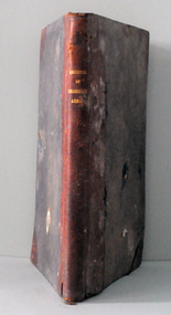
register, Register of Residence Areas, 10.2.1897 - 4.9.1934
This book is a register of land holders with miners' rights. The correspondence is associated with applications for miners' rights on privately owned land and business sites. They include application fotrms and objections to registrations. The areas referred to are Combienbar, Goongerah, Club Terrace, Wombat Creek and Dundong. One of the privileges under the Mines Act, conferred by the holding of a miner's right until 1935 was that of residence on up to one acre on a gold-fields area. Those occupying a residence area were "deemed in law to be possessed ... of such ... parcels ... and the property therein".This is a useful research tool.A large, heavy book with a grey cloth cover and red spine. The end papers are marbled. The inside pages are ruled in grey with red ruled columns. Entries are hand-written. There are copies of correspondence inside. Details given are the registration number and date, the name of the person, the number of the miner's right and its date, a description of the allotment and any remarks or references to other volumes. Any changes of ownership are shown. The book is mostly unused.register-mining miners-rights -
 Torquay and District Historical Society
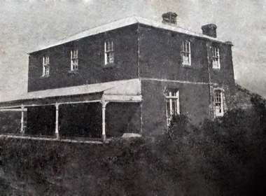
Photograph (copy), Bellbrae Cemetery Memorial Exhibition 2015
Photograph shows Llanberris House, built by Joseph and Mary Gundry on Iron Bark Station, west of the Anglesea Geelong Road, off Menzels Road above Spring Creek. The Gundrys took up Iron Bark station in 1844 and subsequently bought up more surrounding land. Just prior to Joseph's death in 1878, the property comprising 7721 acres was offered for sale as well as conditional rights to adjoining land. Llanberis House was a substantial stone dwelling of 2 storeys with 11 rooms.The Gundry family was one of the pioneering European settlers in the Bellbrae Torquay area.Black and white photographbellbrae victoria pioneer families -
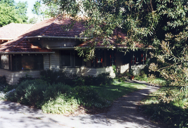 Whitehorse Historical Society Inc.
Photograph, 443 Mitcham Road, Mitcham, 1998
Eric Roger Webb moved to Mitcham with his family in about 1932. They lived at 443 Mitcham Road and owned all the land up to Simpson Street. The land was a grass paddock and he planted native trees and shrubs around the perimeter. The Webbs has three children: Eric, Dean and Donald. Mr Webb worked in the public service. He was a councillor of the Shire of Blackburn and Mitcham and later of the city of Nunawading between 1940 and 1949. He was also a Shire President from 1943-1944.Coloured photograph of a house at 443 Mitcham Road, Mitcham. Tiled roof, verandah, path leading to front door.443 mitcham road, mitcham, houses, webb, eric -
 Bendigo Historical Society Inc.
Document - Fortuna Villa - The Past and the Future
Theodore Batterstedt and his father bought five acres of land on which they built a quartz crushing mill and a two storied, 8 roomed home in 1855. In 1869 they added 2 large rooms to each floor. In 1870 they sold the property to George Lansell. Further additions and renovations too place in 1888' 1890, 1900 and 1907. In 1942 the largely derelict building was compulsorily acquired by the army to house the Land Headquarters Cartographic Company and later the Army Survey Regiment.A 2 page document detailing the history of George Lansell's 'Fortuna' estate.george lansell, fortuna, military -
 Kew Historical Society Inc
Map, Robert Russell, Map Shewing the Site of Melbourne and the Position of the Huts & Buildings Previous to the Foundation of the Township by Sir Richard Bourke in 1837
Map shows the first layout of Melbourne by Government surveyor Robert Russell, who accompanied Governor Richard Bourke in 1837. The surveyed blocks extend from present-day Flinders Street to Lonsdale Street, and Spring Street to Spencer Street, with extensive vacant land west to a salt lake (afterwards Batman's Swamp, later drained), north beyond Flagstaff Hill and south towards South Melbourne. Vegetation coverage is indicated, and tracks and existing buildings and cultivated land are shown.Printed map was created by Day & Haghe, Lithographers to the Queen, sometime after 1838, when the company received its Royal appointment. Copies of the 1837 map exist in several major map collections in Australia; most are uncoloured. This particular map is the earliest in the Kew Historical Society's map collection. It is a nationally significant artefact. Black and white lithographed map hand-coloured in blue and yellow gouache of the town of Melbourne in 1837. In contrast to the original lithograph, the river and the township blocks are coloured blue and yellow. A similar, partly coloured copy is in the collection of the University of Melbourne.maps - melbourne - 1830s, governor sir richard bourke, robert russell - surveyor, cartography -
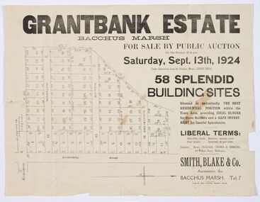 Bacchus Marsh & District Historical Society
Map - Land Sales Plan, Grantbank Estate Bacchus Marsh, 1924
The Grantbank Estate was a parcel of land close to the centre of the shopping area of Bacchus Marsh which was sub-divided and offered for sale in 58 lots on the 13th September, 1924. It comprised an area of 15 acres, being a portion of the Millbank Estate which had been in the hands of the Grant family for 75 years. The lots had frontages to Gisborne Road, Patterson, William and Sutherland Streets. This was a significant sub-division of land and represented a major expansion of residential housing in Bacchus Marsh in the early 20th century.This land sale map is a typical example of housing estate land sales advertising maps produced by real estate agents in this era. The map is significant for the detailed information it provides about when and where land was sold for new housing estates in Bacchus Marsh in the early twentieth century.Printed paper mapland sales bacchus marsh, land subdivsion bacchus marsh, housing estates land sales bacchus marsh, grant family bacchus marsh -
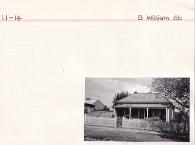 The Beechworth Burke Museum Research Collection
Card (Series) - Index Card, George Tibbits, 13 William Street Beechworth, 1976
George Tibbits, University of Melbourne. Faculty of Architecture, Building and Town & Regional PlanningIndex system that support the research for Beechworth : historical reconstruction / [by] George Tibbits ... [et al]Arranged by street names of BeechworthEach index card includes: street name and number of property, image of property, allotment and section number, property owners and dates of ownership, description of the property according to rate records, property floor plan with dimensions.beechworth, george tibbitsbeechworth, george tibbits -
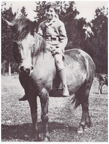 Linton and District Historical Society Inc
Photograph, Gordon Clarke on his Birthday Pony
Gordon Clarke (1906-1996) was the grandson of David Clarke who bought Piggoreet West in 1855. His parents were John Clarke and Mary Jane Newcomen. Gordon Clarke purchased land between Piggoreet and Linton, known as the 'Bird Paddock', and began to intensively plant indigenous species, with a view to providing habitat for native birds. This land was afterwards expanded and is now known as the Clarkesdale Bird Sanctuary. In the 1970s, Gordon donated the sanctuary to the Bird Observers Club of Australia.Black and white copy of original photograph a boy sitting bareback on a horse with no bridle.horses, gordon clarke -
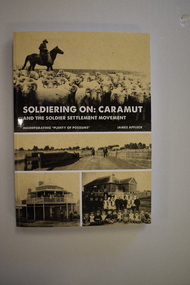 Warrnambool and District Historical Society Inc.
Book, StarPrinting Service Pty ltd, Soldiering On – Caramut and the Soldier Settler Movement, 2018
This book records the history of the post World War Two soldier settlement farms in the Caramut area. Number two in a series of books on Soldier Settlements in Western Victoria.This is a soft cover book of 315 pages. It has a buff-coloured cover with black and white photographs and white printing on the front cover and black printing on the spine. The book includes printed material, black and white photographs, maps and plans. non-fiction This book records the history of the post World War Two soldier settlement farms in the Caramut area. Number two in a series of books on Soldier Settlements in Western Victoria.james affleck, peterborough, soldier settlement, caramut, history of warrnambool, soldier settlement, caramut -
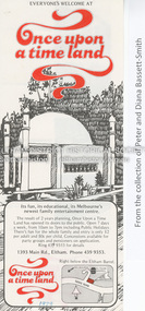 Eltham District Historical Society Inc
Document - Property Binder, 1393 Main Road, Eltham
Flyer, collected 1979, Once Upon a Time Land: pony rides, painting and sculpture, gnomezville, aquarium and reptile house (from collection of Peter and Diana Bassett-Smith).main road, eltham, businesses, once upon a time land -
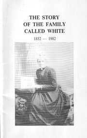 Ballarat Clarendon College
Book, The story of the family called White 1852-1982, c1982
The White were one of the earliest pioneer families to select land in the Ballarat district. Albert Telfer White attended Ballarat College 1912 - 1913 and was killed during WW1. Soft cover, stapled binding, black and white illustration to coveralbert telfer white, world war one, 1914, ballarat college -
 Greensborough Historical Society
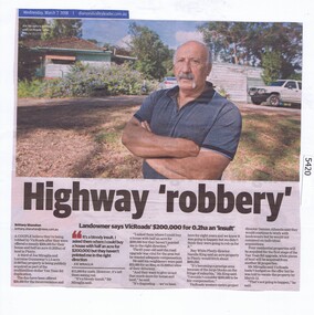
Newspaper Clipping, Diamond Valley Leader, Highway 'robbery', 07/03/2018
A couple believe they're being robbed by VicRoads after they were offered a measly $200,000 for their house and half an acre (0.202ha) of land in Plenty for the Yan Yean Road duplication.News article 1 page, black text and colour image .vicroads, yan yean road, publicly acquired, joe miraglia -
 Greensborough Historical Society
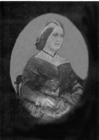
Photograph - Digital image, Anna Flintoff 1855, 1855c
Photograph of a portrait of Anna Flintoff dated circa 1855. The Flintoff family came to Greensborough circa 1841. They owned, farmed and leased land north of the present Civic Drive.Digital copy of black and white photograph.flintoff family, anna flintoff -
 Greensborough Historical Society
Photograph - Digital image, Frederick Nevins Flintoff, 1850c
Photograph of Frederick Nevins Flintoff. The Flintoff family came to Greensborough circa 1841. They owned, farmed and leased land north of the present Civic Drive. A pioneer Greensborough family. A pioneer Greensborough family. Digital copy of black and white studio photograph.frederick nevins flintoff, flintoff family