Showing 27535 items
matching yarra-river
-
 Marysville & District Historical Society
Flyer (item) - Brochure, Artworkz Tourism, Marysville-Steavenson Falls, 2018
A brochure including photographs and a tourist map of Marysville and some of the area's attractions focusing on Steavenson Falls. A brochure including photographs and a tourist map of Marysville and some of the area's attractions focusing on Steavenson Falls. The Steavenson Falls is named after the Victorian Assistant Commissioner of Roads and Bridges, John Steavenson who arrived in Victoria in the early 1860s.Shadowed by over 30 Mountains and/ on the banks of the beautiful Goulburn River/ and Lake Eildon. This is our playground.marysville, steavenson falls, victoria, waterfalls, john steavenson -
Glenelg Shire Council Cultural Collection
Souvenir - Souvenir Program - Glenelg River Bridge Opening Nelson, Victoria, c. 1997
Bowerbird Museum4 Page souvenir program, opening of Glenelg River bridge at Nelson, 21 September 1997. Black and white image of completed bridge on front cover; images of construction phases back cover. Details of opening ceremony and history of Glenelg River crossing at Nelson, inside pages. -
 Federation University Historical Collection
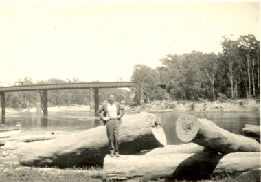
Photograph - Black and White, Frank Wright standing on felled trees, 1940s?
Frank Wright was a renown resident of Smeaton, where he was born on 2 August 1901. He lived at Laura Villa, and attended Smeaton State School. His father William was a gold miner and his mother's name was Sarah. Their family won many singing and instrumental awards. Frank was tutored by Percy Code and was awarded a gold medal for the highest marks in the ALCM examinations in the British Colonies at the age of seventeen years. He became the Australian Open Cornet Champion by the age of eighteen. A year later, Frank conducted the City of Ballarat Band, and later the Ballarat Soldiers’ Memorial Band. He formed the Frank Wright Frisco Band and Frank Wright and his Coliseum Orchestra. These bands won many South Street awards, and Frank as conductor won many awards in the Australian Band Championship contest. In 1933 Frank Wright sailed to England to conduct the famous St Hilda’s Band and was later appointed Musical Director of the London County Council, where he organized many amazing concerts in parks, in and around the London district. He was made Professor of Brass and Military Band Scoring and conducted at the Guildhall of Music and Drama. Frank was often invited to adjudicate Brass Band Championships around Europe, in Australia, including South Street and in New Zealand. The Frank Wright Medal at the Royal South Street competition is awarded to an individual recognized as making an outstanding contribution to brass music in Australia.Black and white photograph of a man dressed in a suit standing on the trunk of a large felled tree. Around him are other fallen tree trunks, all located on the banks of a river. In the background is a bridge spanning the river and on either side of the water are the tall trees of a forest. The man is Frank Wright.frank wright, felled trees, forest, bridge -
 Lakes Entrance Regional Historical Society (operating as Lakes Entrance History Centre & Museum)
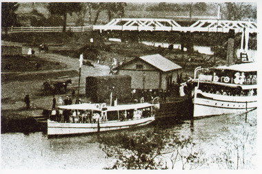
Photograph, 1912 c
Black and white photograph showing steamer Lady Harriet on left, S S Gippsland on right at Bairnsdale wharf on Mitchell River, railway track behind Lady Harriet, horse and jinker at wharf, shed at wharf, road bridge over river with people in background. Bairnsdale Victoriaarts, associations -
 Bendigo Military Museum
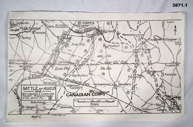
Map - MAPS FRANCE WW1, All 1918
(.2) Areas on map relate to : The Hindenburg line on the left, from the top, Bony to Bellicourt to Bellenglise, Estrees to Brancourt. (.3) The River Somme runs through from top corner left bottom corner right. Main areas are Belloy, Picquigny, Bertangles, Montieres. The map finishes just short of “Amiens” Items in the collection relating to F.A.W Hutson No 3539 AIF. refer Cat No 922 for his service history.(.1) Map on paper showing the “Battle of August 1918”, Map C, The Advance to “Lions & Proyart”. (.2) Trench map, gauze lined, sheet 62B N.W, trenches corrected to 8.2.1918, German trenches in blue, scale 1:20,000, France. (.3) Ordnance survey map, May 1918, France, Edition 1, sheet 62 E N.E, scale 1:20,000, a canal and river runs through the centre(.2) On rear hand written “62 B N.W” (.3) On rear hand written “D.M.F 62 E N.E”august 1918, maps, somme -
 Orbost & District Historical Society
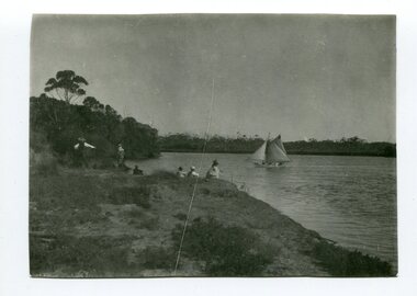
black and white photograph, C1900
This is a fishing party at Bream Point, Marlo C 1900.Marlo has always been a popular destination for fishing. This is a pictorial record of an early fishing group at Marlo.A black / white photograph of a small group - possibly a family - fishing off a river bank. A small ketch is on the water.on back - Near Bream Pointmarlo-fishing recreation -
 Kiewa Valley Historical Society
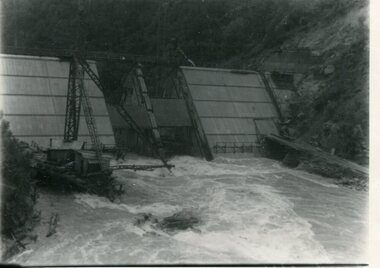
Photograph - Kiewa River in flood at Clover Dam
As part of the push to cut electricity costs and diversify supply, the Victorian Government (circa 1930) implemented the conversion strategy from mainly brown coal supply to hydro - electricity. The Kiewa Hydroelectric Scheme became the largest scheme of its kind in the State Of Victoria and the second largest scheme in Australia. Clover Dam and Power Station were built by the State Electricity Commission of Victoria as part of the Kiewa Hydro Electric Scheme from the late 1930's to the early 1940's. This dam was constructed to supply water to feed four turbines (62 mega watts) at the West Kiewa Power Station. This was at the forefront of sustainable "Green" energy. Costs associated with power supplies is still a major incentive of governments, however environmentally friendly alternatives such as wind and nuclear have also made inroads. The Kiewa valley and its surrounding alpine catchment were looked at(Victorian State Government), from the beginning of the twentieth century as a source of alternate power for an ever-increasing demand for electricity by growing population and heavy industrial areas within Melbourne City and State regions. Construction of dams, such as Clover Dam provided the large quantity holding areas of water required to turn the turbines at the various power stations to provide the electricity needed. The impact of these controls by moderating water run-off from the alpine regions is beneficial in reducing flooding from thawing of snow on the alps. This by-product allows agriculture and grazing to be less vulnerable to seasonal flooding thereby resulting in a more stable annual production level.Black and white photograph of Clover Dam with Kiewa River in flood. .5mm white boarder on 3 sides of photo.Handwritten on back of photograph in black pen - Kiewa in flood. Clover Dam.clover dam, secv -
 Kiewa Valley Historical Society
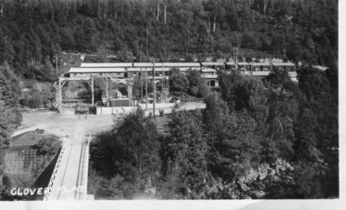
Photograph - Clover Dam
As part of the push to cut electricity costs and diversify supply, the Victorian Government (circa 1930) implemented the conversion strategy from mainly brown coal supply to hydro - electricity. The Kiewa Hydroelectric Scheme became the largest scheme of its kind in the State Of Victoria and the second largest scheme in Australia. Clover Dam and Power Station were built by the State Electricity Commission of Victoria as part of the Kiewa Hydro Electric Scheme from the late 1930's to the early 1940's. This dam was constructed to supply water to feed four turbines (62 mega watts) at the West Kiewa Power Station. This was at the forefront of sustainable "Green" energy. Costs associated with power supplies is still a major incentive of governments, however environmentally friendly alternatives such as wind and nuclear have also made inroads. The Kiewa valley and its surrounding alpine catchment were looked at(Victorian State Government), from the beginning of the twentieth century as a source of alternate power for an ever-increasing demand for electricity by growing population and heavy industrial areas within Melbourne City and State regions. Construction of dams, such as Clover Dam provided the large quantity holding areas of water required to turn the turbines at the various power stations to provide the electricity needed. The impact of these controls by moderating water run-off from the alpine regions is beneficial in reducing flooding from thawing of snow on the alps. This by-product allows agriculture and grazing to be less vulnerable to seasonal flooding thereby resulting in a more stable annual production level.Black and white photograph of Clover Dam buildings and Kiewa River. Has a .4cm white border around photograph Printed on bottom left corner of photograph in white - Clover Flatclover dam, secv -
 Mission to Seafarers Victoria
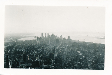
Photograph - Photograph, Black and white, Allan Charles Quinn, Down Town New York, 10 September 1949
Allan Charles Quinn was a member of the Merchant Navy from aged 16 as well as being a trained photographer. This photograph was taken during his travels through America whilst still being associated with the Merchant Navy.This photograph captures the New York skyline of 1949 in very clear detail. This photograph is part of a larger collection, know as the Allan Charles Quinn collection, which provides a photographic autobiography of the life of an individual seafarerBlack and white photograph of Manhattan and Hudson River showing skyscrapers in the background with other buildings and general cityscape in foreground.Blue handwritten ink on reverse of photograph "10-9-49".photographs, mission-to-seafarers, seamen, hudson-river, skyscrapers, new-york, allan-charles-quinn, manhattan, skyline, cityscape -
Glenelg Shire Council Cultural Collection
Negative - Negative - Glenelg River, Nelson, Victoria, c. 1936
Transparency for black and white photo. Two ladies looking through trees at Nelson, Vic Glenelg River in background -
Glenelg Shire Council Cultural Collection
Negative - Negative - Glenelg River Nelson, Victoria, c. 1936
Negative for a black and white photograph. Image shows Mouth of Glenelg River at Nelson, Victoria. Woman standing in the dunes. -
Glenelg Shire Council Cultural Collection
Negative - Negative - Glenelg River, Nelson, Victoria, Miss Zillah Maschmedt, photographer, c. 1936
Negative for a black and white photograph. Image shows Glenelg River, Nelson, Victoria, sand dunes at mouth in distance. -
Glenelg Shire Council Cultural Collection
Slide - Slide - Glass Plate Negative, 1890-1910
Glass plate negative. Group of men and women standing on bank of river. Mostly grassland, very few trees. -
 Orbost & District Historical Society
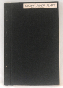
plans, 1966?
These survey plans are a useful research tool.A flat green fabric folder with a white label with "SNOWY RIVER FLATS" hand-written in black. It contains plans.plans-survey snowy-river-flats department-crown-lands-victoria -
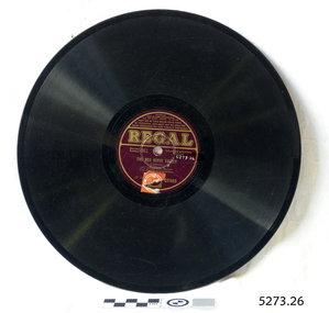 Flagstaff Hill Maritime Museum and Village
Gramophone Record
Bakelite record by Regal T1232 "The Red River Valley" sung by baritone Art Leonard No G21555 Record cracked.flagstaff hill, warrnambool, shipwrecked-coast, flagstaff-hill, flagstaff-hill-maritime-museum, maritime-museum, shipwreck-coast, flagstaff-hill-maritime-village -
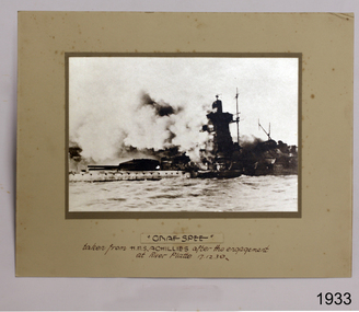 Flagstaff Hill Maritime Museum and Village
Photograph
Photograph of Graf Spee taken from HMAS Achilles after the engagement at River Platte 17 Dec 1939flagstaff hill, warrnambool, shipwrecked-coast, flagstaff-hill, flagstaff-hill-maritime-museum, maritime-museum, shipwreck-coast, flagstaff-hill-maritime-village, photograph of graf spee, photograph, graf spee -
Port Melbourne Historical & Preservation Society
Badge - Port Melbourne Lions Club, Brim, c. 1975
Collected by Fred WINDUSS: Port Melbourne Lions ClubPort Melbourne Lions Club badge, gold on navy blue; West Gate Bridge, river, ship depictedsocieties clubs unions and other organisations, frederick robert winduss -
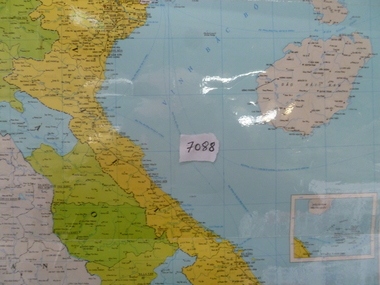 National Vietnam Veterans Museum (NVVM)
Map, Map of Vietnam, Lao, Campuchia
Laminated colour map of Vietnam, Laos and Campuchia. Map details rivers, hamlets, town and all geographical features.laos map, vietnam map, campuchia map -
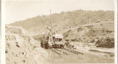 El Dorado Museum Association Inc.
Photograph (item) - Digital Image
Cocks Pioneer Creek Diversion. Cocks Pioneer Electric Gold & Tin Mine Company was formed in 1899. The company's first power station, located at the eastern end of the valley began operating with its 340 Kilowatt steam-powered generator. By 1909, from 2,500,000 cubic yards worked, reported recovery was 17,284 ounces of gold and 224 tons of tin ore. By 1909, Cocks Pioneer’s power plant had become inadequate and uneconomical. The barge was floated downstream about a mile, but lost time caused the operations to cease. Following testing, a new mine was established by diverting Reid's Creek at a cost of £25,000. Settling dams were built, one of which held 1,935,900 cubic feet. Sold earth banks, built against a wall of stringy bark saplings constructed and laced with vertical props, were built. In 1914, the company was reformed as Cock’s Pioneer Gold and Tin Mines NL, another power station was constructed at the western end of the township, near the junction of Clear and Reid's Creeks. From 6,800,000 cubic yards of material processed, the returns were 64,397 ounces of gold and 855 ton of tin. Cocks Pioneer mine then moved the barge downs stream and continued sluicing. In 1929 Cocks Pioneer Electric Gold and Tin Mining Company ceased operations due to a drop in values. Cock’s Pioneer Gold and Tin Mines NL carried on large-scale hydraulic sluicing operations until 1941. mining, gold, tin, cocks pioneer, creek, gold mining, tin mining, el dorado, eldorado -
Tatura Irrigation & Wartime Camps Museum
Plaque, 1961
Large brass plaque commemorating the opening of a State Rivers and Water Supply Commission building in Carnegie by the Premier in 1961SRWSC, This building was officially opened on September 14th 1961 by the Hon H.E Bolte MLA Premier of Victoria and the Hon W.J. Mibus MLA Minister of Water Supply -
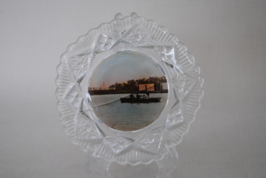 Anglesea and District Historical Society
View Ware Dish, Estimated 1920's
Decorative glass surround. Plain centre with scenic view of Anglesea River, bridge and rowers. Crack across centre.anglesea, rowers, view ware -
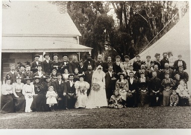 Tatura Irrigation & Wartime Camps Museum
Photograph, Brady-Maidment wedding
Donated by Brady descendant. Couple Brady-Maidment. Attendants : Jas Brady with R Brady and M Maidment. Descentants of Brady family still reside locally.Copy of wedding party, 1896, taken at Maidment's home on Broken River, Kialla. Marquee erected for evening use.weddings, fashions, customs, photography, photograph, slides, film -
Lakes Entrance Regional Historical Society (operating as Lakes Entrance History Centre & Museum)
Book, Palmer, Molly, Gippsland - Our Changing Environment, 2000
Booklet describing the life of a young fishing family on the silt jetties at the mouth of the Mitchell River, Gippsland Lakes, Victoriaboats and boating, topography, fishing industry -
Lakes Entrance Regional Historical Society (operating as Lakes Entrance History Centre & Museum)
Photograph, M O Fish, 1933
Also two other black and white photographs of same scene from a different angle 05198.1 and .2 6.5 x 9 cmBlack and white photograph of Buchan from Gelantipy Road with the river, bridge and sale yards below Buchan Victoriawaterways -
Lakes Entrance Regional Historical Society (operating as Lakes Entrance History Centre & Museum)
Postcard, Rose Series P4087, 1970
Black and white postcard showing a woman and two children beside a timber bridge over the river at Bruthen VictoriaThe Bridge Buchan Victoriadams -
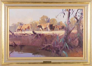 Wangaratta Art Gallery
Painting, Ross Paterson, Riverbank Shepparton, 2007
Rural City of Wangaratta Collection, Wangaratta Art Show Grand Winner 2007.A pastoral landscape of cows grazing beside a river, painting with oils in shades of brown, green, yellow, red, and blue.Obverse: Ross Paterson/ (bottom right corner)wangaratta art gallery, ross paterson, landscape, painting, pastoral, riverbank, cows -
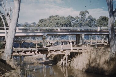 Stawell Historical Society Inc
Slide, Ian McCann, Three Bridges
Three Bridges across a river, two oled wooden ones and the newer concrete one in the centre. at Campbells Bridgebridges, campbells bridge -
 Ballarat Heritage Services
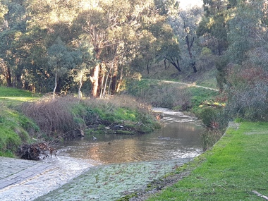
Photograph, Clare Gervasoni, Yarrowee Channel Near Hill Street, Ballarat, 27/06/2021
Photographs of the channelled and unchanneled Yarrowee River near Hill Street and Redan. Ut shows were the channel ends.yarrowee river, yarrowee creek, yarrowee channnel, bluestone channel, bluestone -
 Whitehorse Historical Society Inc.
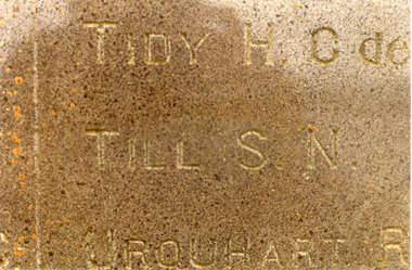
Photograph, War memorial
Contained in a letter from Hon Secretary of McClean District Historical Society, stating - Sydney Norman TILL born at Harwood Island, the son of Richard Ernest TILL and his wife.Coloured photograph of war memorial on Harwood Island, enclosed by iron rails and stone posts. Background of the Clarence River.war memorial harwood island, till, sydney -
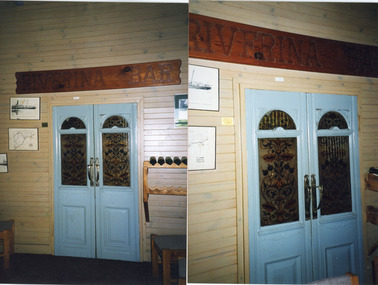 Lakes Entrance Regional Historical Society (operating as Lakes Entrance History Centre & Museum)
Photograph, 1997
and pic of coloured painting of of SS Riverina 16 April 1927 off MallacootaColour photograph showing double doors removed from the wreck of the SS Riverina in the hotel at Cann River, Victoria.shipwrecks, ships and shipping