Showing 27535 items
matching yarra-river
-
 Lakes Entrance Regional Historical Society (operating as Lakes Entrance History Centre & Museum)
Photograph
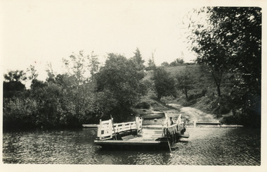
Black and white photograph of the Tambo Upper punt showing the puntman bringing the empty punt across the Tambo River.boats and boating, waterways, transport -
 Lakes Entrance Regional Historical Society (operating as Lakes Entrance History Centre & Museum)
Photograph, H D Bulmer, 1945 c
Photograph had previously been stuck down to a page and pulled off. Damage on backBlack and white photograph of Tambo River flats and Bruthen in distance with maize crop growing on flats Bruthen Victoriawaterways, topography -
Lakes Entrance Regional Historical Society (operating as Lakes Entrance History Centre & Museum)
Photograph, 1940 c
No 2 in series of fiveBlack and white photograph showing men and horses with scoop opening an entrance to the mouth of the Snowy River Marlo Victoriaboats and boating, jetties, waterways -
Lakes Entrance Regional Historical Society (operating as Lakes Entrance History Centre & Museum)
Photograph, 1940 c
No 5 in series of fiveBlack and white photograph showing men with horses and scoops opening an entrance to mouth of Snowy River Marlo Victorianatural disasters, public works, vegetation -
 South Gippsland Shire Council
Framed lithograph featuring Agnes River, Corner Inlet, Gippsland, 1983
Framed lithograph featuring Agnes River, Corner Inlet, Gippsland. Drawn from nature and lithographed by Nicholas Chevalier. -
 Sunbury Family History and Heritage Society Inc.
Photograph, 1935
The old weir constructed in the Jacksons Creek in Sunbury is featured in the photograph.A black and white photograph with a cream border of a waterfall tumbling over a built up rocky wall across the river.weirs, jacksons creek -
 Sunbury Family History and Heritage Society Inc.
Photograph, 1935
The waterfall is in Jacksons Creek downstream from the Sunbury township.A black and white photograph with a cream border of a waterfall in a river. A gnarled tree is growing on the bank and there is a hill in the middle distance.waterfalls, jacksons creek, sunbury -
 Port Fairy Historical Society Museum and Archives
Photograph
Moyne BridgeBlack and white photograph in an embossed card frame of the West side of the traffic bridge over the Moyne river Postcardmoyne bridge, gipps street, traffic, moyne river -
 St Patrick's Old Collegians Association (SPOCA)
Photograph - Students, 1920s
-
 Bendigo Historical Society Inc.
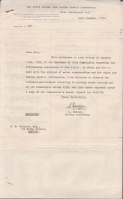
Document - EDWIN BUCKLAND COLLECTION: THE STATE RIVERS AND WATER SUPPLY COMMISSION, 1939
Dolcument. The State Rivers and Water Commission. Ref. letter Janusary 17th 1939 to Chairman of A.N.A. and Water Conservation. -
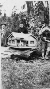 Upper Yarra Museum
Negative Photographic Reproduction, Model Powelltown built by Primary school pupils, 14.2.1983
03056 Model Powelltown built by Primary school pupils Upper Yarra Shire 1888-1988 Centenary collection. Negative, Black & white. Scanned at 600 dpimodel powelltown built primary school pupils model house -
 Whitehorse Historical Society Inc.
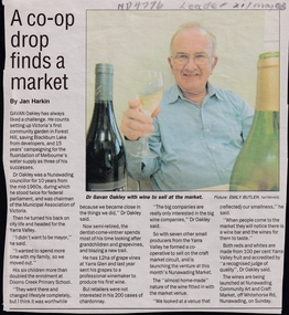
Article, A Co-op drop finds a market, 2003
Gavan Oakley, ex Nunawading Councillor, has now started a co-operative making wine in the Yarra Valley. He is launching his venture at Nunawading Market.Gavan Oakley, ex Nunawading Councillor, has now started a co-operative making wine in the Yarra Valley. He is launching his venture at Nunawading Market.Gavan Oakley, ex Nunawading Councillor, has now started a co-operative making wine in the Yarra Valley. He is launching his venture at Nunawading Market.viticulture, oakley, gavan, nunawading market -
 Whitehorse Historical Society Inc.
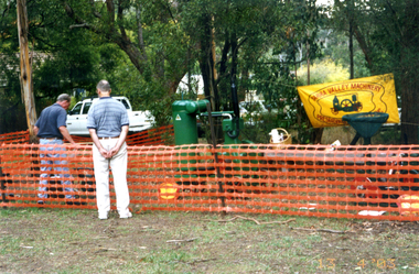
Photograph, Heritage Day 2003, 13/04/2003 12:00:00 AM
Coloured - Yarra Valley Machinery Preservation Society's display for Whitehorse Historical Society's Heritage Day held at Schwerkolt Cottage and Museum Complex on 13 April 2003yarra valley machinery preservation society, whitehorse historical society, heritage day 2003 -
University of Melbourne, Burnley Campus Archives
Letter (Item), Letter to T.H. Kneen from James Bell re article on the "Scent Farm", Dunolly
-
 Bendigo Historical Society Inc.
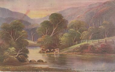
Postcard - Alice McGregor Postcard Collection, 1900 - 1920
Alice McGREGOR Born: 1908; unknown parents. Possibly adopted by the Salter family? Electoral Roll 1936: Highland Terrace Kangaroo Flat. Alice Mary Salter and William Robert Salter living together; presumed to be sister and brother. William Robert Salter was killed in a MVA in Bendigo in 1937 aged 26. In Victoria in 1938, Alice Mary Salter married James Thomas McGregor (born Victoria 1917, died Victoria 1983, buried Fawkner Cemetery) Lived: 1968; 22 Wade Street Golden Square Alice McGregor Died: 1999 aged 91 at Anne Caudle Centre, Bendigo Buried: Kangaroo Flat Cemetery See additional research. Postcard Album of Alice McGregor contained 86 post cards.Postcard Album of Alice McGregor contained 86 post cards. See 1400. Colour painting of a rural scene of 2 cows beside the Yarra at West Warburton. Addressed to Miss H G Shatford, Black Rock, Via Sandringham, Victoria Sender J G D, Emu Park, W East Dated 25 Oct 1906 postcard, collector, alice mcgregor -
 Port of Echuca
Black and white photograph, 04/03/1984
Photograph related to no.P000041, P000045 - P000048 of P. S. Adelaide re-floating. Copyright held by Riverine Herald newspaper. Original and negatives held by Riverine Herald.. Photograph taken from the river looking south west as the Adelaide enters the water backwards, from the soil ramp . The right hand side of the photograph is in shadow so is very dark. 2 people can be seen on the deck with possibly another boat moored beside the Adelaide and a small motor boat to the left of that.A significant social and historical event in Echuca as many local community groups had committed many hours and much money to re-float the Adelaide to add it to the stocks for the development of the Port of Echuca as a major tourist attraction for the region.Black and white photograph of re-floating of the P. S. Adelaide in the river, possibly still partly on soil ramp. Deep shadows on the right prevent detail of front of the boat and much of the right hand bow. There are spectators in a small motorboat on left of the Adelaide and possibly another boat coming along the side of the Adelaide (2 people can be seen on the left hand side of the Adelaide). 2 people are on the deck of the Adelaide.p. s. adelaide, echuca,victoria,re-floating of the p. s. adelaide. riverine herald newspapers, -
 Bendigo Historical Society Inc.
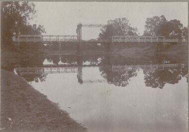
Photograph - BRIDGE - SINGLE SPAN
sepia photo on grey board: single span lift bridge across river. Long truss spans each side of lift section. Probably over Murray River ? On front rop right corner Mp 107. On back written ' copies obtainable from M. Clifton, Koondrook'M. Clifton ?bridge, construction, single span lift bridge -
 Wodonga & District Historical Society Inc
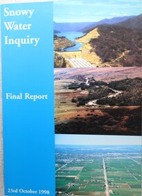
Book - Snowy Water Inquiry Final Report 23rd October 1998, Robert Webster et al, 1998
The Snowy Water Inquiry was commissioned in 1998 with a brief to recommend environmental water release options to the Commonwealth, Victorian, and NSW Governments so that corporatisation of the Snowy Mountains Scheme could proceed. This book contains the findings of the Inquiry into water allocation and uses of the Snowy River.A book of 160 pp - Snowy River Inquiry Final report 23rd October 1998. Submitted to the Governments of New South Wales and Victoria / Commissioner: The Hon. Robert Webster. On the front cover are three aerial photographs of the Snowy River and Snowy Hydro Scheme. The book contains maps and photographs.non-fictionThe Snowy Water Inquiry was commissioned in 1998 with a brief to recommend environmental water release options to the Commonwealth, Victorian, and NSW Governments so that corporatisation of the Snowy Mountains Scheme could proceed. This book contains the findings of the Inquiry into water allocation and uses of the Snowy River.snowy river hydro, snowy river government inquiry, water allocations, water resources developmen -
 Whittlesea Historical Society Inc.
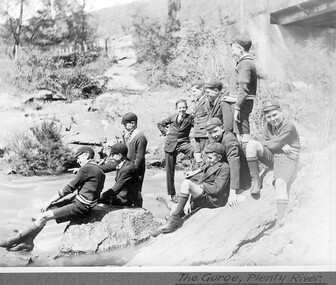
Document, Australian Silver Presentation Trowel
The foundation stone of a new bridge over the Plenty River at Morang (now Mernda) was laid by Mrs. John Wilton of Wilton Vale, in August 1866. The silver trowel was presented to Mrs. Wilton by Moses Thomas, chairman of the road board. The bluestone bridge was officially opened by Moses Thomas on the 12th of February 1867.The location of the silver trowel in this rare image is unknown.A4 single page (double sided) with image and a list of items numbered 461 - 495.Item 486. Important Australian Silver Presentation Trowel., inscribed "Presented to Mr John Wilkin of Wilkin Dale Morang on the Occasion of the Laying of the Foundation Stone, the Bridge of the Plenty River at the Junction of the Parishes of Morang and Yan Yean by the Morang District Road Board, August 1866, Fine Engraved Scroll Decorated Border, Turned Ivory Handle, Maker R. R. Illustrated Page 27.silver trowel, morang bridge, mernda bridge, john wilton, wilton family, moses thomas, wilton vale -
 Kiewa Valley Historical Society
Photograph - Folder of Photographs (KVHS 1150 A - F) – Photocopied set of black and white photographs from the display folder (pages 1 - 8) put together by KVHS to document life on the Kiewa Valley Hydro-electric Scheme
Although the Kiewa Hydro-Electric Scheme was first proposed in 1911, construction did not commence until 1938. As part of the push to cut electricity costs and diversify supply, the Victorian Government (circa 1930) initiated the conversion from primarily brown coal supply to hydro – electricity. Field investigations during the 1940’s resulted in a new proposal for a scheme that had more than double the capacity of the 1938 scheme. The Kiewa Hydroelectric Scheme became the largest scheme of its kind in the State Of Victoria and the second largest scheme in Australia. The number of personnel involved in the planning and construction of the scheme increased dramatically. During the late 1940’s, most activity centred around the construction of the West Kiewa Power Station, Rocky Valley Reservoir, McKay Creek Power Station and the Bogong Creek Aqueduct.A common thread across all the larger hydro scheme constructions was the need for workers, both qualified and unqualified who came from around the world seeking a new life for themselves and their families. New accommodation and facilities were required for the army of workers engaged in construction in often remote and wild areas. The SEC had a high demand for timber, and set up the first of a number of sawmills at Bogong Creek in 1939 and set up the first hardwood logging in the headwaters of the Kiewa River. These new ‘towns’ such as Mt Beauty and Bogong, survived, serving the needs of operational personnel and their families, and expanding with growth of new industries. Mount Beauty, and to a lesser extent Bogong, are among these places. Large A3 size spiral bound display folder containing 21 of 58 pages of photocopied black and white photographs of various aspects of the early days of the Kiewa Valley Hydro-electric scheme including equipment, various work sites and photographs of workers and their families. 1-Front page; 2-Security gate at Mt Beauty Camp; 3-Channel 1 on East Kiewa River; 4-Junction Dam – Diversion Tunnel Inlet; 5-Sawmill; 6- Homan’s Gap Sawmill; 7 Junction Dam: 8-Homan Dam Site-Diamond Drilling on River Buttress; 9- Homan Dam Site View Upstream 10-Homan Dam Investigation Camp 1-Windsor & Newton Visual Diary 60 sheet (120 pages) 11’ x 14’ 280 x 356mm 110 GSM Acid Free Drawing Paper 2-1940-Security Gate on Mt Beauty side of Kiewa River bridge. Part of old Mt Beauty camp and mess in background 3- STATE ELECTRICITY COMMISSION OF VICTORIA Date; 11.3.40 Time: 10.30am No K35 Kiewa Hydro Electric Works. Diverting East Kiewa River into Channel Page number 1 4-STATE ELECTRICITY COMMISSION OF VICTORIA Date: 5.4.40 Time: Noon No K58 Kiewa Hydro Electric Works. Junction Dam – Diversion Tunnel Inlet – Normal Flow Page number 2 5- STATE ELECTRICITY COMMISSION OF VICTORIA Date: 19.8.42 Time: 2.30pm No K883 Kiewa Hydro Electric Works. Sawmill – General View Page number 3 6- STATE ELECTRICITY COMMISSION OF VICTORIA Date: 12.1.42 Time: 2.00pm No K540 Kiewa Hydro Electric Works. Homan’s Gap Sawmill – General View Page number 4 7- STATE ELECTRICITY COMMISSION OF VICTORIA Date: 12.1.42 Time: 2.00pm No K540 Kiewa Hydro Electric Works. Junction Dam – General View looking upstream Page number 5 8- STATE ELECTRICITY COMMISSION OF VICTORIA Date: 16.11.45 Time: 10.32amm No K52153 Kiewa Hydro Electric Works Homan Dam Site – Diamond Drilling on River Buttress Page number 6 9-STATE ELECTRICITY COMMISSION OF VICTORIA Date: 15.1.45 Time: 4.10pm No K1781 Kiewa Hydro Electric Works Homan Dam Site – View Upstream Page number 7 10- STATE ELECTRICITY COMMISSION OF VICTORIA Date: 15.1.45 Time: 4.10pm No K1781 Kiewa Hydro Electric Works Homan Dam Investigation Camp 1944 – 1945 Page number 8 secv; kiewa hydro electric scheme; mt beauty; bogong; construction work; -
 Eltham District Historical Society Inc
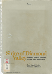
Book - Report, Gunn Hayball Pty Ltd Architects and Planners, Shire of Diamond Valley, Feasibility Study of Community Arts and Crafts Requirements, 1977
This report was prepared in response to a brief issued by the Shire of Diamond Valley to investigate the requirements for arts/crafts in the Shire and suggest options available in satisfying those requirements.Ex Yarra Plenty Regional Library - Local History, Dewey labels and catalogue stamp inside rear covershire of diamond valley, community arts and crafts, feasibility study -
Bendigo Historical Society Inc.
Map - KIMBOLTON : COUNTY OF BENDIGO, 1966
Map. Kimbolton, County of Bendigo. Eppalock, Lyell, Knowsley, Langwornor, Redesdale, County of Dalhouse, County of Rodney, Campaspe River, Coliban River,By authority A.C.Brooks, Government Printer, Melbourne. Drawn and reproduced at the Department of Lands and Survey, Melbourne, 1966, Price $1.00 (number 65 in map cupboard 1)A.C. Brooks, Government Printer, Melbourne.map, bendigo, kimbolton -
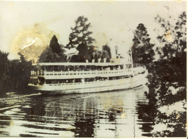 Lakes Entrance Regional Historical Society (operating as Lakes Entrance History Centre & Museum)
Photograph, 1910 c
Black and white photograph showing the S S Gippsland in Mitchell river, near Bairnsdale, shows three pine trees, other vegetation and a building on far bank, reflections in river,people on board, hull painted white, similar to a Bulmer postcard showing ship leaving Bairnsdale. Bairnsdale Victoriajetties, ships and shipping, waterways -
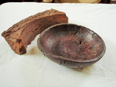 Wangaratta Historical Society
Wooden Fruit Bowl, Red Gum Bowl
This wood is made from Red River Gum tree wood, these trees live for between 500 to 1,000 years of age. The wood in this bowl has been carbon dated in the USA to be 4,500 years old.This bowl is significant because of the age of the wood it is made from. 000016 Wooden Fruit Bowl The timber this fruit bowl was made from was a red gum tree taken from the Ovens river at Tarrawingee (12 km from Wangaratta)where it had been submerged for years. It was made on a lathe by Ken Hill. The bowl warped and cracked shortly after being turned. A piece of the wood was taken to the USA by a visitor where it was carbon dated to be 4500 years old Measurements: Diameter: 22cm Height: 6cm Colour: Dark red brown Photographed beside a piece of natural red gum Tarrawingee is 12 Km North East of Wangaratta on the Great Alpine Road Significance: 4500 year old red gum wood is rare in this area. red river gum wooden bowl wangaratta historical society -
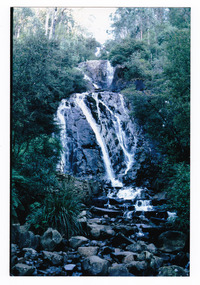 Marysville & District Historical Society
Photograph (item) - Colour photograph, Pre 2009
A colour photograph of Steavenson Falls in Marysville in Victoria.A colour photograph of Steavenson Falls in Marysville in Victoria. The Steavenson Falls is named after the Victorian Assistant Commissioner of Roads and Bridges, John Steavenson who arrived in Victoria in the early 1860s.steavenson falls, waterfalls, marysville, victoria, john steavenson -
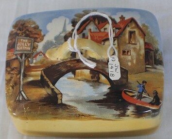 J. Ward Museum Complex
Container - Butter Dish "The Jolly Boatman"
Everyday kitchen items added a feeling of "home" in many of Victoria's institutions. The vintage butter dish is significant in its representatives of a kitchen object frequently used in Victorian institutions. Objects such as these tell the stories of peoples everyday lives.Inscribed with “The Jolly Boatman” River scene – boat, bridge and cottage Two pieces – dish and lid Yellow porcelain – crazed Manufacturer: Lancaster & Sandlandkitchen item, dish -
Glenelg Shire Council Cultural Collection
Photograph, 1950-1960
Sourced from Casterton Town Hall former shire of GlenelgBlack and white photo. Sedan driving across old wooden bridge over shallow river/creek; side-on viewBack: Photographer's stamp, round, purple -
Glenelg Shire Council Cultural Collection
Negative - Negative - Sapling Creek, Glenelg River, Nelson, Victoria, c. 1936
Transparency for black and white photo. 'Sapling Creek' 26 miles upstream from mouth of Glenelg River at Nelson, Vic -
Glenelg Shire Council Cultural Collection
Negative - Negative - Glenelg River, Victoria, c. 1934
Part of a collection of photographs taken by Zillah Maschmedt in 1934. Zillah was a teacher from South Australia.Transparency for black and white photo. View along Glenelg river at Nelson, Victoria. Township on right, bridge centre of the photo.zillah maschmedt, photography, glenelg river -
Glenelg Shire Council Cultural Collection
Negative - Negative - Donovan's Landing, Glenelg River, Nelson, Victoria, c. 1936
Transparency for black and white photo. Wooden dinghy tied up to jetty at Donovan's Landing, Glenelg River, Nelson, Vic