Showing 11119 items
matching planning
-
 Lakes Entrance Historical Society
Book, Landsmith Pty Ltd, North Arm Action Plan, 1996
This plan was formulated as a comprehensive guide for sustainable management of the waters and environment of the North Arm while providing recreational opportunities that are in balance with the environmental values of the North Arm and its catchment Lakenvironment, vegetation, recreation -
Lakes Entrance Historical Society
Book, East Gippsland Community Wellbeing Reference Group, East Gippsland Shire Community Well-Being Plan 2005, 2005c
Plan provides a new framework for legally required municipal public health in which community wellbeing can be considered within council and more broadly in the community East Gippsland Victoriahealth services, education, houses -
University of Melbourne, Burnley Campus Archives
Plan, Proposed Tennis Court, School of Horticulture Burnley, 1956
Hand drawn plan of proposed tennis court and its position in the Gardens. Built with funds raised by the Ladies' Auxiliary in 1961 and demolished February 1990 to make way for new laboratories.Signed THK(?) 15/7/56ladies' auxiliary, burnley school of horticulture, tennis court -
 Ballarat Tramway Museum
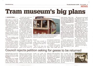
Newspaper, The Courier Ballarat, "Tram Museum's big plans", Dec. 2019
Set of 7 items related to the proposed extension of the BTM's depot to the south, Dec. 2019. Comprises: .1 - Newspaper clipping from The Courier, 19/12/2019 titled "Tram Museum's big plans", advising that the proposal was being advertised by Heritage Victoria, along with a photo of No. 26. .2 - Newspaper clipping from The Courier, 18/12/2019 for the advertising the permit application under the Heritage Act 2017 - in the Public Notice section. .3 - Digital image of "Museum Extension - Heritage Impact Statement - revised Oct. 2019." - 16 A4 pages. .4 - Digital image of Plans - 8 sheets of the proposal by MKM constructions. .5 - Digital image of Report - Urber Arbor - Arboricultural Report - Tree Management Plan. .6 - Digital image of Coloured site plan and drawings showing proposal depot trackwork and support mechanism around trees. Note this does not open on dbTextWorks interface. .7 - Digital image of 11 sheets of concept plans for the exterior and interior of the museum proposal by MKM Constructions. .8 - digital image of the advertising sign on the rear wall of the depot taken 7-1-2019. A similar poster was on the south east corner of the depot.btm, museum, drawings, depot extensions, heritage buildings, heritage, trackwork -
Glen Eira Historical Society
Letter - Gardenvale Road, 78, Gardenvale
This file contains six items. Five items of typed correspondence concerning application to build four double-storey dwellings at 78 Gardenvale Road. Correspondence between City of Glen Eira and residents R.A. and P. Darke from 08/12/2008 to 20/03/2009, and Paul Siedle. Typed copy of resident Jonathon Breedon’s objections to the proposed plan. Copy of original plans for the dwellings dated 12/09/2008. Copy of amended plans for the four dwellings dated November 2008. Typed letter dated 20/03/2009 from Glen Eira Senior Town Planner to Richard and Peta Darke notifying of council’s decision of intention to grant a planning permit for the dwellings. Typed five page notice of decision to grant a planning permit for the four dwellings dated 20/03/09. Included is a one page description of the appeal process.gardenvale road, magnolia road, gardenvale, city of glen eira, city hall, glen eira road, hawthorn road, lloloma receptions, caulfield south, darke peta, darke richard, elster avenue, elsternwick, torres ron, kokkinos stella, glen eira city council, statutory planning department, breedon jonathon, lantana road, peter l. brown architects pty ltd., glen eira planning scheme, elsternwick library, bentleigh library, carnegie library, caulfield library, staniland grove, jasper road, shepparson avenue, bentleigh, carnegie, caulfield, siedle paul, townhouses, town planning, plans, aerial photographs, architectural drawings, architects, brick houses -
 Kiewa Valley Historical Society
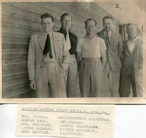
Set of 4 photographs of SECV Clerical staff, 1940 - 1941
The Kiewa Hydroelectric Scheme is the largest hydro-electric scheme in Victoria and the second largest in mainland Australia after the Snowy Mountains Scheme. The scheme is situated in the Australian Alps in north-eastern Victoria about 350 km from Melbourne and is wholly owned by AGL Energy. The scheme was originally constructed between 1938 and 1961 by the State Electricity Commission of Victoria although it was privatised in the 1990s. The scheme was originally developed solely for electricity generation, unlike the Snowy Mountains Scheme, which was also intended to direct water west of the Snowy Mountains for purposes of irrigation. From 1937 to 1944 the construction of dams at Pretty Valley, Rocky Valley and the Junction Dam were undertaken requiring large numbers of planning and support staff to see the projects successfully completed. Planning and support staff were the backbone of the successful completion of the Kiewa Valley Hydro Electric Scheme and contributed significantly to the development of the Kiewa Valley area. Many descendants of the men in the photographs still living and working in the local areaSet of 4 black and white photographs of SECV clerical staff – Circa 1940/1941Typed on note glued to back of each photo, Numbers handwritten in blue ink in top left hand corner 1. DRAWING OFFICE STAFF KIEWA C. 1940-41 Bob Morgan – Construction Draftsman; Duncan Kerr – Draftsman; Rob Hollands – Survey Draftsman; Arthur Keeble – Office Engineer; Bill Godfrey – Draftsman 2. CLERICAL OFFICE STAFF KIEWA Peter Harnetty – Clerical; Bert Connors – Clerical; John Martin – Stores Clerical; Ken Calder – Head Storekeeper; Bill black – Construction Records 3. CLERICAL OFFICE STAFF KIEWA Jack Norman, Herb Kendall, Jack Bray – Stores Clerical; Ken Calder – Head Storekeeper; Jim Swain, George Milner – Stores Clerical; Jim Gleeson – Storekeeper; John Martin – Stores Clerical 4. OFFICE STAFF KIEWA C. 1940 Don Faulkner – Cadet Engineer; Tas Davies – Survey Draftsman; Bob Morgan – Construction Darftsman; R.J. Martin, Arthur Keeble – Office Engineers; Rob Hollands – Survey Draftsman; Jack Wollard – Head Surveyor; Harry Wilson – Plan Officer. Printing Plans Handwritten in red ink on back of photo 4 – Refer Rob Hollands secv clerical staff -
Eltham District Historical Society Inc
Document - Folder, McFarland, Sue
Sue McFarland, Eltham potter, won Box Hill Institute of TAFE's 2004 Teacher of the Year. Contents Newspaper article: "Potter plans for Japan show," Diamond Valley Leader, 30 March 2005, reports Sue McFarland's award and plans.Newspaper clippings, A4 photocopies, etcsue mcfarland -
 Bendigo Historical Society Inc.
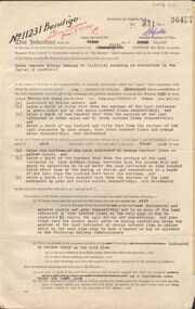
Document - MCCOLL, RANKIN AND STANISTREET COLLECTION: GOLD MINING LEASE NORTH DEBORAH MINING COMPANY, 29th August, 1950
6 page indenture, plus plan, between King George V and North Deborah Mining Company in the Parish of Sandhurst, dated 29th August, 1950 to operate a gold mine. Indenture numbered 11231 Bendigo, Vol 331 and Folio 36457. Plan shows Hargreaves Street, Violet Street, Lily Street, Sullivan Street railway line, and leases numbered, 11230; 2107; 11062, 11033, 11013, 11219, 11175. Shafts and tracks indicated. Dam shown on lease 11013. Scale 8 CHAINS TO A INCH. Coloured key to plan shows depths, Crown Land, and surface excised. Total area of lease 48 acres, 3 roods, 22 perches.bendigo, mining, north deborag mining company, north deborah mining company, hargreaves, violet, lilly, sullivan streets. -
 University of Melbourne, Burnley Campus Archives
Document - Personal files, Andrew Smith's Files, 1981-2022
cactus, cacti, clematis, orchard redevelopment, r. hall, geoff olive, pruning garden, field station, vcah, university of melbourne, burnley, jill kellow, field station redevelopment, field nursery, student gardens, turfgrass, grassy woodland, chris findlay, phil tulk, grasslands, herbaceous border, car park, native garden, restoration native garden, john rayner, hilda kirkhope rockery, herb garden, rainforest garden redevelopment, plant lists, shady walk, salvia, trees, tai-haku cherry, tree management, tree lists, david aldous, grey border -
 Greensborough Historical Society
Programme - Document, The Patchwork Gallery, Watsonia Quillt Wander (WQW), 2004_08
Event promotion and planning document for the Watsonia Quilt Wander 20046p. programme promotion document, stapledlayt family, quilting, debra layt, the patchwork gallery -
 Greensborough Historical Society
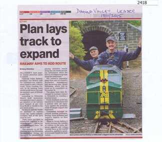
Newspaper Clipping, Plan lays track to expand, 18/11/2015
Outlines plans to expand the Diamond Valley Miniature Railway in Eltham.News clipping, black text, colour image.diamond valley miniature railway -
Federation University Historical Collection
Book, Jacob Lamaro et al, Daylesford Environmental and Physical Plan Sub Report, c2007, c2007
This report was done by University of Ballarat 'Tourism Planning and Development' students.White soft covered book of 33 pages. daylesford, mineral water, hepburn, flora, fauna, wombat state forest, lake daylesford, geology, hepburn reserve, tourism -
Federation University Historical Collection
Book, Tanya Wisneske et al, Daylesford Marketing Plan, c2006, c2006
This report was done by University of Ballarat 'Tourism Planning and Development' students.Soft covered book of 29 pages. daylesford, hepburn, tourism, marketing plan -
 Stawell Historical Society Inc
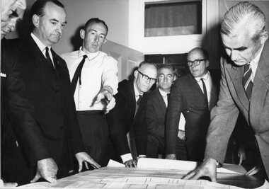
Photograph, New Stawell Technical School -- Examining the plans 1967
Examining Plans of New Stawell Technical School. Stawell 1967stawell education -
 Peterborough History Group
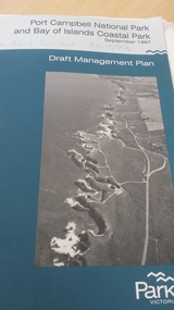
Book, Port Campbell National Park and Bay of Islands Coastal Park Draft Management Plan September 1997, 1997
Information re planning for Park released for public comment in 1997.Contributes information on the history and development of the Bay of Islands Coastal ParkGovernment published 81 page + maps book.peterborough 3270, bay of islands coastal park, parks victoria - peterborough, bay of islands -
 Ballarat Heritage Services
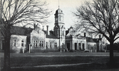
Photograph - Image, Maryborough Railway Station, c1951
Maryborough Railway Station was built in Victoria's heyday of railway planning. A black and white photograph of Maryborough Railway Stationmaryborough railway station, maryborough, architecture -
 Robin Boyd Foundation
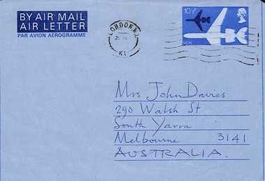
Letter - Aerogram, John Barry, 20.03.1978
To Patricia Davies from John Barry, London, with travel plans. -
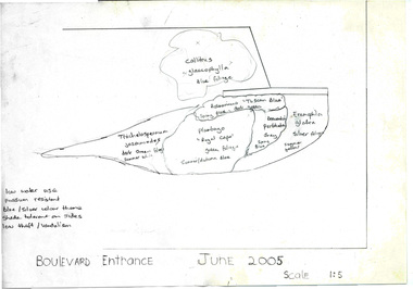
 Friends of Ballarat Botanical Gardens History Group
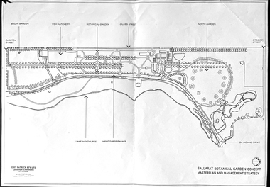
Work on paper - Ballarat Botanical Garden Concept, Masterplan and Management Strategy, Unknown
This map is important in terms of the planning and management of the Ballarat Botanic Gardens The Map adds to our understanding and knowledge of the history of the Ballarat Botanical Gardens 1 page of a map in black and white. the number 44 is circled in pencil on the top righthand corner of the back of the page.john garner, doctor, john garner collection, ballarat botanic gardens, maps, masterplan, management strategy, john patrick, landscape consultants, ballarat city council, friends of ballarat botanical gardens, gardens, ballarat -
 City of Kingston
Pamphlet - Colour, W. H. Wood Estate Agent, Subdivisional Land Auction Barker's Estate Cheltenham, 1919
Sales plan for land in the suburb of Cheltenham, along Barker StreetThe developing urban area of Cheltenham within the City of Kingston. This land sale pamphlet illustrates the subdivision of land within the municipality and the changing demographic of the district as new houses are constructed.Colour pamphlet advertising subdivisional land auction of Barker's estate, on Barker Street Cheltenham.Handwritten in grey pencil on the subdivision map: a series of numbers on each block possibly indicating the sale price. Handwritten in grey pencil on the subdivision map: Roy- joined to subdivision 6 Handwritten in grey pencil on the subdivision map: x on the border between subdivision 17 and 16, and again on the border between subdivision 12 and 11.cheltenham, land sales, estate -
 Greensborough Historical Society
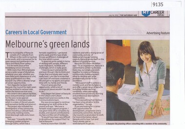
Article - Newspaper Clipping, The Age, Careers in Local Government - Melbourne's green lands, 14/07/2012
Discusses employment at Banyule City Council in particular the planning departmentNewspaper text and colour imagebanyule city council, town planning, careers -
 Greensborough Historical Society
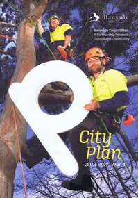
Book, Banyule City Council, City plan 2013-2017, Year 4, 2013-2017
A review of the Banyule Council's Plan - a partnership between Council and Community.Soft cover, 132 p., col. illus.banyule city council, community, banyule council, town planning -
 Bendigo Historical Society Inc.
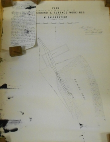
Document - MARKS COLLECTION: PLAN RELATING TO UNDERGROUND AND SURFACE WORKINGS VICTORIA HILL
Plan on paper: on top of plan 'plan showing the position of the underground & surface workings in the claim of Mr. Ballerstedt Victoria Hill' Signed by Thomas Forbes, Mining Surveyor, 22nd. April 1868' Attached to plan is a letter report accompanying plans on the underground workings in (illegible) Ballerstedt & Sons, Victoria Hill (ink blot covering writing RH side) Text of letter begins : the underground level southwards from the shaft is 4ft 6' x 6 ft wide as shown on the plan; and is at a depth of (illegible) from the surface; along the (illegible) of which the timbering both upright and cap-pieces; are now in as good condition as when the work was being proceed with; with the exception of the uprights and one cap-piece which are slightly crushed from the general settlement of the mullock. The timbering of the drives is still standing in the same position though upwards of 12 months has elapsed after the slip in the open cutting had taken place, showing very clearly in my mind that the slip could not be attributable to the insufficient timbering of the underground workings; but rather to the action of the weather in this particular part of the cutting. The probably quantity of mullock that was detached or slipped from the west side of the cutting; would be (from careful enquiry and observation ) about 1500 loads at least; enough to crush the whole of the timber in the levels, if it had not been of the most substantial character and I think yours to prove that the fall was not caused by any defective timbering but from the cause already stated. I may state that I have inspected the underground workings generally in the mine, and the timbering is of the most substantial characterbendigo, mining, victoria hill -
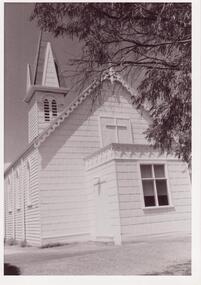 Glen Eira Historical Society
Plan - Trinity Congregational Church, Glen Huntly
Black and white photograph donated in 2002 by Bob Sinclair. Shows front porch. Hand drawn plan of rear interior of Trinity Congregational Church. Shows plan of doors and windows as well as circular leadlight window and vestry doors. Not Known by whom or date.trinity congregational church, primitive methodist church., grange road., glen huntly, sinclair bob -
Melbourne Tram Museum
Document - Digital image - Domain and St Kilda Roads - overhead works, Public Transport Victoria (PTV), April 2025
Pamphlet or document for the reconnection of the the overhead at Anzac station interchange to the previous overhead in Domain Road. The work was planned for the weekend of 13/6 to 16/6 2025. Gives a map of the work site, works and that they were no changes to planned tram services. Published by the PTV.Yields information about the Domain Road tracks at Anzac Station.Digital image of a four page document.tramways, trams, domain road, overhead, anzac station -
 Eltham District Historical Society Inc
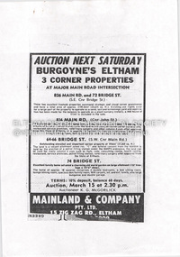
Document - Property Binder, 826 Main Road, Eltham
Photocopy advertisement, sale three corner properties at Main Road intersection, by Burgoyne family. Newspaper article: Nod for medical centre plan, Diamond Valley News, May 31, 1995 - Nillumbik Council approved plans for medical facility and chiuld minding centre at the corner of Bridge Road and Main Road however not all members of the Planning Special Committee were in support - eventually did not proceed and units were built with the address of 72 Bridge Roadmain road, eltham, property, burgoyne family, medical centre, 72 bridge street, 826 main road, bridge street, child minding centre, don cordell, jim connor, nillumbik planning special committee, tony lazzarotto -
 Wonga Park Community Cottage History Group
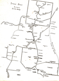
Plan (sub-item) - Plan re moving State School to corner of Yarra and Brysons Roads
A plan prepared by Mr. A.J. Upton (secretary and convenor of the Wonga Park School Committee) in about 1920, when residents were pressing for a new school to be located at the junction of Bryson’s and Yarra Road, the object being to combine the Wonga Park and Yarra Road Schools. Although the proposal was eventually dropped, this plan shows who lived in Wonga Park in the 1920’s and where they lived. [It is likely that this plan dates from some time after 1920.]wonga park school -
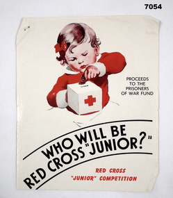 Bendigo Military Museum
Poster - POSTER, RED CROSS, Red Cross, "Who will be Red Cross Junior?", 1943
Refer Cat No’s 7028, 7029 for VAD, Red Cross and fund raising.This is a quarto sized poster with glossy white paper. Printing is in red ink. Main image shows a little toddler with red bow in her hair, placing a penny into a Red Cross money box. A sign in black ink beside it states - Proceeds to the Prisoners of War Fund. At the bottom is a little statement Red Cross 'Junior' Competition.Staple hole on top LHS. On the rear, in pencil, are the raffle plans and prizes = Babyset - Palmer Club Raffle - Wireless - (YMCA Dance on 17th) - Hann Raffle - Bicycle - Love Birds - Permit for (S..?) Ann - Radio Drive. ww2, pows, red cross -
Whitehorse Historical Society Inc.
Article, An open or shut case
After Nunawading Council rejecting Club 25's appeal for a planning permit for a brothel in Mitcham.After Nunawading Council rejecting Club 25's appeal for a planning permit for a brothel in Mitcham. Owner of the brothel, Bruce Roberts, has appealed to the Planning Appeals Tribunal and his appeal is to be heard 20 September. A new group has been set up and funds raised from St John's Catholic Church, Mitcham, Brothel Action Reform Group to support the anti-brothel group and have engaged legal experts.After Nunawading Council rejecting Club 25's appeal for a planning permit for a brothel in Mitcham. brothels, st johns catholic church, mitcham, rossiter, bob, wattle park gospel chapel, watson, al, roberts, bruce, club 25, brothel action reform group, galbally, frank, victoria. planning appeals board., thornton crescent -
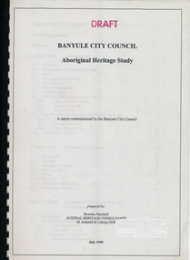 Eltham District Historical Society Inc
Book, Banyule City Council Aboriginal Heritage Study prepared by Austral Heritage Consultants, 1998 July
A draft report on the pre-European Aboriginal achaeological sites in the city of Banyule, including results of previous field surveys; Banyule covers a small part of the former lands of the Woi Wurrung. The report discusses heritage overlay, planning issues and the proposed Victorian planning provisions.100p, 30 cm.Marked "Draft"aboriginal heritage banyule, woi wurrung -
Port Melbourne Historical & Preservation Society
Document, Port Melbourne Management Framework - Managing Change Draft Report May 2003, 2003
Planning report produced by City of Port Philipp which addresses planning issues affecting Port Melbourne area, from Bay street to Beacon Road. Used as lobbying tool in relation to Beacon Cove Stage 8. Historical section inaccurate and not to be relied upon.Port Melbourne Management Framework - Managing Change Draft Report May 2003. Acetate cover, wire binding, 117 pagespiers and wharves - town pier, town planning, built environment, piers and wharves - station pier, piers and wharves - princes pier, beacon cove