Showing 10951 items matching " land"
-
 Orbost & District Historical Society
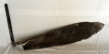
hay knife, c. 1900 - 1950
Used in agriculture in the Orbost district, to cut hay or silage, most likely on the Mundy farm. The original Mundy family moved to a land "selection" at Betebolong in the early 1880's from Buchan. A large flat iron blade with an iron handle attached. The blade is sharper on the bottom side and shows some evidence of perhaps having been serrated.agricultural-implement hay-silage-knife -
 Bunjil Park Aboriginal Education & Cultural Centre
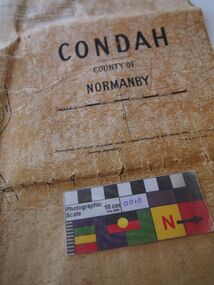
Map, Original titles map of Lake Condah and surrounds, Condah, County of Normanby
This map shows the area around Lake Condah including the land identified as Aboriginal Reserves. Aboriginal people including the Jaara were forcibly removed from their country and resettled in reserves like this. This map is significant as it shows one of the areas that Jaara people were forcibly removed to from their homelands. -
 Whitehorse Historical Society Inc.
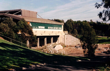
Photograph, Waste Transfer Station
The waste centre is situated next to Dandenong Creek and opposite Mahoneys Road Vermont South. Land fill was used until the 1980's when Whitehorse joined the "least Waste" program.Coloured photograph of the City of Whitehorse Recycling & Waste Centre, rear view. Situated in Vermont South near Dandenong Creekwaste transfer station, whitehorse transfer station, waste, recycling -
 Melton City Libraries
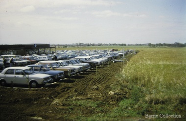
Photograph, West Melton Regional Shopping Centre, 1973
Kilpatrick house which stood on the site until the 1970s on the land now occupied by the Regional Shopping Centre later to be renamed Woodgrove. Opening of the Centre views from the parking areas and paddocksOpening of the West Melton Regional Shopping Centre taken from the carparklocal significant events, local identities -
 City of Kingston
Pamphlet - Colour, Brock Bros, South Brighton Township Estate, 1888
Sales plan for land in the suburb of South Brighton (Moorabbin), bounded by Point Nepean Road, South Road, Patterson Street and the Mordialloc Railway Line. Incorporates Wolsely Street and Gordon StreetThe developing urban area of Moorabbin within the City of Kingston. This land sale pamphlet illustrates the subdivision of land within the municipality and the changing demographic of the district as new houses are constructed close to infrastructure.Colour pamphlet advertising for private sale the South Brighton Township Estate, South Brighton. Incorporates a map of the estate bordered by Point Nepean Road, South Road, Patterson Street, and the Mordialloc Railway Line. Includes Wolsley Street and Gordon Street. land sales, south brighton, estate, moorabbin -
 Sunbury Family History and Heritage Society Inc.
Photograph, c 1930s
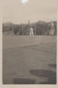
The man was photographed playing tennis on the tennis courts that were sited on railway land in Evans Street Sunbury behind the Sunbury Post Office band in the vicinity of the present day bus station.A small non-digital black and white snapshot of a man on a tennis court.tennis, tennis courts -
 Eltham District Historical Society Inc
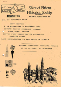
Newsletter, Newsletter, No. 69 November 1989
Contents: • Next meeting, Speaker Panel: Land Development in the Shire of Eltham • November Meeting • Recent Activities • Eltham Community Festival • Flavour of Eltham • Other Things You Should Know The Shire of Eltham Historical Society was formed in October 1967. The first newsletter of the Society was issued May 1978 and has been published continuously ever since on a bi-monthly basis. With the cessation of the Shire of Eltham in late 1994, the Society's name was revised to Eltham District Historical Society and this name first appeared with issue No. 103, July 1995. The collection of the Society's newsletters provides a valuable resource on the history of the Society's activities, office bearers and committee members, guest speakers and subjects of historical interest pertinent to the former Shire of Eltham and the Eltham District.A4 photocopied newsletter distributed to membersnewsletter, eltham district historical society, shire of eltham historical society -
 Bialik College
Document (Collection) - Israel Kipen collection, Box 2
1960s1960s -
 Mount Evelyn History Group
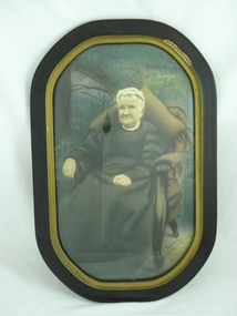
Photo (framed) L Morrison, Seated portrait of Mrs Louisa Morrison nee Haag (?), c. 1940
This item was donated as a photograph of Louisa Morrison. Louisa (or Luisa) Rosanna Morrison nee Haag came from an early settler family in the farming community of Wandin. The woman photographed is in her old age. If this is indeed Louisa Morrison, the photograph would date from the early 1940s, since she died in 1946 at the age of 70. However the costume and the style of the photo suggest an earlier date, possibly the early 1900s. This could be Louisa's mother, Emma Martha Haynes, or mother-in-law Margaret (McNeil) Morrison. The woman is shown in a garden, probably because the family were farmers/orchardists. Louisa married Daniel McNeil Morrison, who was nine years her senior , in 1900. They had four children and farmed Morrisons' Orchard in Old Hereford Road, Mt Evelyn. The Morrison home was to become the important community house in Mt Evelyn, Morrison House. Morrison Reserve is part of their land, as was Yarra Hills Secondary College, Mt Evelyn Special Developmental School and the Reserve and Athletics facilities, including a tennis club. In 1981 the land title was changed to the Shire of Lillydale, who purchased the land and established the Morrison House Community House from 1976 (ie before they legally owned the land).This picture is of social significance as it is the only reputed picture of Louisa Morrison nee Haag.Brown round cornered frame with gold colour on inner frame. Painted plaster on frame chipped on top right. Coloured (painted) photograph of seated woman in upholstered chair with large brown cushion behind her. Garden setting. Black floor length dress, high necked, long sleeved. White cap on head. White cloth showing at neck.Bottom right hand corner, signature "F. RAPHAEL". Reverse: four inscriptions, one on each straight side, stamped in ink. Top: "MADE IN / AUSTRALIA". Right side: "THIS MOUNTING IS SPECIALLY DESIGNED AND / SELECTED WORKMANSHIP AND MATERIALS / GUARANTEED". Bottom: Table, 1 row, 2 columns. 1st cell: "STYLE / 1". 2ND CELL: "PRICE / 3 GNS". Left: box with 2 columns, 1 row. Left most column is divided horizontally into two, as is the 2nd column, but at a lower level. This creates four cells. Top left: "STYLE 1". Bottom left "PRICE 2 GNS". Top right: "TO BE SOLD AT PRICE MARKED OPPOSITE ONLY ON CONDITION THAT SAME IS MOUNTED ON ONE OF OUR SAMPLE STUDIES". Bottom left: "EMPIRE ART COMPANY LIMITED".louisa, morrison, haag, morrison house, farming, orchard, mt evelyn, photograph, wandin -
 The Beechworth Burke Museum Research Collection
Card - Index Card, George Tibbits, Ford Street, Beechworth, 1976
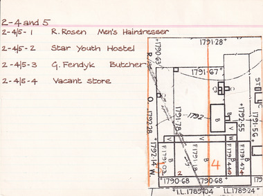
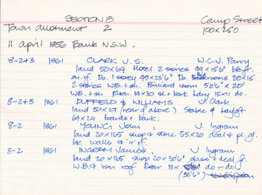
Property - Ford Street, Beechworth - Section 2, Town Allotments 4 - 100' x 250' - Note: (see also Town Allotment 5, 2-4/5-1, 2-4/5-2, 2-4/5-3 and 2-4/5-4) Ownership details and history - 28 Oct 1853 - W.H. Neuber 2-4+5 - 1861 - Wallace, Peter, unlisted, J.A. Wallace, I. 105'x165' Hotel 86'x21', 2 Stories WB. sh. rf. Dp. 84'x18' do----do. Theatre 75'x26' do. Office 18'x20' do, Billiard room 35'x22' sl. & sh. rf. Kitchen 45'x25' slabs, Back Bldg. 22'x15' do. Stables 60'6"x 20'6" do. 2-4 - 1861 - Hearn, William, unlisted, J. Gray, land 13'6"x25' shop 13'6"x25' plate glass fr. WB. + sh. rf. 2-4+5 - 1863/4 - Clark, J.S. Publican, same, land 105'x165' Hotel & bedrooms 105'x18', 2 stories WB. + sh. rf. Store at back 10'x24' Stables, slabs, battenwork, + sh. 113'x26' Kitchen 45'x25' slabs + bark rf. Store 14'x9' WB + bark, Ldry 11'x10' WB + sh. Theatre 75'x26' WB + sh. 2-4 - 1863/4 - Richter, A. Mrs Gray, bld 13'6"x25' shop as above 2-5 - 1866 - Brown, John, barber, J.S. Clark, shop + back rooms, 18'x16' part "Star Hotel Bldgs" £55 2-4 + 5 - 1866 - Clark, John Sitch, publican, same. land 105'x165' "Star Hotel" 61'x41' 2 stories bk bldg + sh. rf. Bedrooms from front along "Star Lane" 105'x18' 2 stories WB + sh. rf. In rear store 24'x10' slabs + sh. rf. Kitchen 45'x25' slabs + bark rf. Ldry 11'x10' WB + sh. Store 14'x9' W.B. + bark rf. £330 2-4 - 1866 Clark, J.S. Publican, same, 'Theatre" 75'x26' WB + sh. roof £70 2-4 + 5 - 1866 Crawford, Hiram Allen - also 16-17, Connolly, Michael, coach owners, J.S. Clark "Star" stables 120'x26' slabs trellis work & sh. rf. £30 2-4 - 1866 - Richter, Augustus, Watchmaker, William Telford, land + Prem as 1861 £52 no entry - 1871 - Isaacs, Alfred, Clothier, J.S. Clark, shop 18'x18'. part of Star Hotel Buildings 2-4 + 5 - 1871 - Clark, J.S. Publican, same hotel as 1866 £300 no entry - 1871 - Clark, J.S. Publican, same, coach office 14'x12' part of old Star Theatre £20 no entry - 1871 - Brasch, Morris, Clothier, J.S. Clark, shop 14'6'x50' part of old Star Theatre, £65 2-4 + 5 - 1871 - Clark, J.S. Publican, same, Stables 120'x26' slabs + sh. roof. £26 2-4 - Richter, A. Watchmaker, Wm. Telford, land + prem as 1861 £45 no entry - 1876 - Issacs, Alfred, tailor, F.K. Allen, shop and dwelling, part of Star Hotel Bldgs, £40 2-4 + 5 - 1876 - Allen, Frederick K. Hotelkeeper, same. land + hotel as 1866 + coach office part of old Theatre £160 2-5 - 1876 - Crawford, H.A. - Connolly, M. Coach Proprietors, F.K. Allen stables, 120'x26' slabs + sh. roof £78 no entry - 1876 - Galbraith, Andrew L. Confectioner, F.K. Allen, double shop 15'x50' part of old Star Theatre £65 no entry - 1876 - Richter, Augustus, Watchmaker, W. Telford, J.G. Orr. land + prem as 1861 £40 no entry - 1884 - O'Connor, David M. Hairdresser, shop + prem, portion of Hotel Bldg 2-4 + 5 - 1884 - Allen, F.K. Publican, same "Star Hotel" 2-4 - 1884 - William, Robert, Bootmaker, F.K. Allen - double shop 2-4 - 1889 - Crawford, Connolly & McCurdy, Coach Proprietors, F.K. Allen, Star Stables, Sheds + Land £60 2-4 - 1889 - Dunn, Fred, Bootmaker, F. Allen, shop, prem + land £15 2-4 + 5 - 1889 - Carroll, Wm. Hotelkeeper, F. Allen, Star Hotel. prem + land £135 2-4 - 1889 - Williams, Robert, Bootmaker, F. Allen, double shop + prem + land £40 2-4 - 1900 - Philips, William R. Blacksmith, Wm. Carroll, Star Stables and land £25 2-4 - 1900 - _unoccupied) , William Carroll, land £5 2-4 + 5 - 1900 - Lowe, John, Hotelkeeper, Wm. Carroll, Star Hotel premises £130 2-4 - 1900 - Vandenberg, George, Dentist, H. Vandenberg, surgery + land £10 2-4 - 1906 - Lod, Wm. G. Star Lane, Blacksmith, execs. W. Carroll, Star Stables and land £20 2-4 - 1906 - Dumbrell, Starr & Jarvis, Watchmakers, execs. W. Carroll, shop + land £40 2-4 + 5 - 1906 - Lowe, John. Hotelkeeper, W. Carroll execs. of Star Hotel and land £130 2-4 - 1906 - Vandenberg, Henry, not tenant issued, land £10 Note: execs. = executors 2-4 and 5 - 1976 2-4/5-1 - R. Rosen - Men's Hairdresser 2-4/5-2 - Star Youth Hostel 2-4/5-3 - G. Fendyk, Butcher 2-4/5-4 - Vacant Store Architectural Index Card - Brian Pump and Tony Dugan - Photographers beechworth, george tibbits -
 The Beechworth Burke Museum Research Collection
Card (Series) - Index Card, George Tibbits, Camp Street, Beechworth, 1976
George Tibbits, University of Melbourne. Faculty of Architecture, Building and Town & Regional PlanningIndex system that support the research for Beechworth : historical reconstruction / [by] George Tibbits ... [et al]Arranged by street names of BeechworthEach index card includes: street name and number of property, image of property, allotment and section number, property owners and dates of ownership, description of the property according to rate records, property floor plan with dimensions.beechworth, george tibbitsbeechworth, george tibbits -
 Halls Gap & Grampians Historical Society
Photograph - B/W, Oct-86
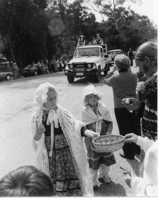
This is part of a parade held on the main street of Halls Gap in conjunction with the 150th anniversary of Major Mitchell's visit to the area. The photo shows two young girls wearing flower patterned dresses, frilly hats and shawls standing on the edge of a road. The front girl is offering flowers in a straw basket to people lining the street. A Toyota land cruiser with people dressed in what appears to be park ranger or scout uniforms standing in the tray is driving down the road and an old car can be seen behind that. People and cars line the far side of the road and trees can be seen behind them.events, parades -
 Federation University Historical Collection
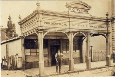
Photograph, Documents and Photographs relating to Hugh Gray of Ballarat, c1880s
The CD-ROM contains images from the Hugh Gray familyA CD-ROM of images relating to Hugh Gray, including: * A shopfront in Dana Street, Ballarat. A man, thought to be Charles Gray (son of Hugh Gray), stands out the front. * Ballarat School of Mines Certificate for Charles Ralston, student of Telegraphy, 1874 * Charles Ralston, exhibitor at the 1st Australian Juvenile Exhibition * Convention of Land and Reform League * Hugh Gray's Business License, 27 April 1857 * Ballarat Mechanics' Institute 13th Concert * John Basson Humffray Testimonial Ticket, 1857 hugh gray, charles ralston, telegraphy, charles ralston, australian juvenile exhibition, convention of land and reform league, business license, ballarat mechanics' institute concert, john basson humffray -
 Federation University Historical Collection
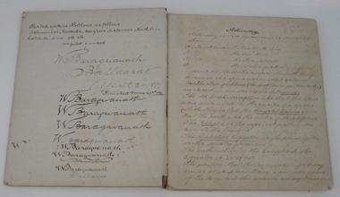
Book - Exercise Book, Astronomy Notes by William Baragwanath, 1897
William Baragwanath studied at the Ballarat School of Mines, obtained a Geology certificate in 1911. He was born on 01 August 1878 at Ballarat. He joined the Victorian Department of Mines in 1897 and was Chief Mining Surveyor from 1924 to 1943. Baragwanath died at Prahran on 20 September 1966. See Book 2 - Catalogue Number 4530Marbled card covered exercise book with brown tape spine containing handwritten notes by William Baragwanath on Astronomy and astronomical, geodetic, geights and distances, North Line Latitue, Lime, etc., problems . Headings include: Astronomy refraction Correction for Semi diameter Determination of True Meridian Elongation Observation Latitude Determining the TIme Convergence of Meridian Barometric Measurement of Heights Formulae Latitude Observation On the Division of Land Calculations for Observations by a Single Altitude Computations Triginometrical Rations of Two Arcsballarat school of mines, astronomy, william baragwanath -
Federation University Historical Collection
Books, British and Continental Music Agencies Ltd, Sheet Music, mid 1900s
Frank Wright was a renown resident of Smeaton, where he was born on 2 August 1901. He lived at Laura Villa, and attended Smeaton State School. His father William was a gold miner and his mother's name was Sarah. Their family won many singing and instrumental awards. Frank was tutored by Percy Code and was awarded a gold medal for the highest marks in the ALCM examinations in the British Colonies at the age of seventeen years. He became the Australian Open Cornet Champion by the age of eighteen. A year later, Frank conducted the City of Ballarat Band, and later the Ballarat Soldiers’ Memorial Band. He formed the Frank Wright Frisco Band and Frank Wright and his Coliseum Orchestra. These bands won many South Street awards, and Frank as conductor won many awards in the Australian Band Championship contest. In 1933 Frank Wright sailed to England to conduct the famous St Hilda’s Band and was later appointed Musical Director of the London County Council, where he organized many amazing concerts in parks, in and around the London district. He was made Professor of Brass and Military Band Scoring and conducted at the Guildhall of Music and Drama. Frank was often invited to adjudicate Brass Band Championships around Europe, in Australia, including South Street and in New Zealand. The Frank Wright Medal at the Royal South Street competition is awarded to an individual recognized as making an outstanding contribution to brass music in Australia.Five books of sheet music (full scores). They are the scores of five different pieces of music owned by Frank Wright. 1). 'Karelia Suite' by Sibelius. Printed with a buff coloured cover. 2). 'The Heavens are Telling, Chorus from The Creation'. Music by Haydn. This has notation throughout the piece in lead pencil and red pencil. 3). 'Symphony of Marches, for Brass Band', by Gilbert Vinter. 4). 'Coriolanus' by Cyril Jenkins. 5). 'The Land-of -the-ever-Young, Hebridean sea poem', by Granville Bantock1). The title is written in pen on the front cover. 2). Red pencil notation throughout the piece and in pencil on the front cover - The musical Director, Belfast Philharmonic Orch, Belfast, N. Trelor? 3). In pencil on front cover - Grave p19 and Brioso(?) p36. 5). In pencil on the front cover - 2nd & 5frank wright, sheet music, full score, the land of the ever young, coriolanus, symphony of marched for brass band, the heavens are telling, karekia suite, sibelius, haydn, gilbert vinter, cyril jenkins, granville bantock -
 Ringwood and District Historical Society
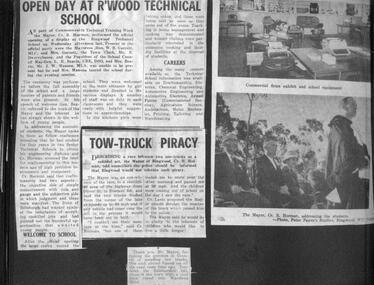
Newspaper, From RC Horman scrapbook, Mayor of Ringwood 1960/61
August 1962, Elizabeth Penny elected as first woman Councillor of Ringwood Open Day of Ringwood Technical School as part of the Commonwealth Technical Training Week by Mayor RC Horman 80,000 pound to build Aged-Care home in Kirk St, Ringwood. Work expected to start in February 1962. Land donated by Ringwood Council. The Richmond Lions Club has donated a sizable amount. Pam Deuter awarded American Field scholarship Ringwood CWA 12 birthday. -
 Bendigo Historical Society Inc.
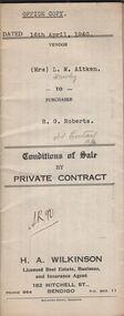
Document - H.A. & S.R. WILKINSON COLLECTION: CONDITION OF SALE
conditions of sale by private contract dated 16th April, 1940 between Mrs L. M. Aitken (seller) and R. G. Roberts (buyer) for land situate at 299 high Street, Bendigo at present occupied by Mr. R.G. Roberts and having a frontage of approx. 42 feet 6 inches to High Street by a depth of approx. 135 feet 6 inches, together with 6-roomed brick, weatherboard and rough cast dwelling and all sundry. Price 850 pounds.organization, business, h.a. & s.r wilkinson real estate -
 Bendigo Historical Society Inc.
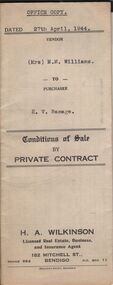
Document - H.A. & S.R. WILKINSON COLLECTION: CONDITION OF SALE
Conditions of sale by private sale dated 27th April 1944 between Mrs M.M. Williams (seller) and H.V. Ramage (buyer) for land situate Cohn Street near Holdsworth Road, Bendigo, being allotment 16 section K1, containing 2 acres, 1rood and 20 perches more or less in the City of Bendigo, described in Crown grant volume 6207 folio 1241225, together with 4-roomed weatherboard building, iron tank and all sundry. Price 33 pounds.organization, business, h.a. & s.r wilkinson real estate -
 Bendigo Historical Society Inc.
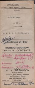
Document - H.A. & S.R. WILKINSON COLLECTION: CONDITION OF SALE
Conditions of sale by private contract issued by H.A. Wilkinson and dated 24th April, 1950 between Miss E. Conn (seller) and G.J. & G.B.R. Rodier (buyer) for land situate Pitt Street Bendigo, at present occupied by Mrs. Holsdon as tenant, having a frontage of 66ft. By a depth of 82.5ft. Part of Crown allotment 6 section 60B described in certificate of title volume 2538 folio 507552, together with 6-roomed weatherboard dwelling and all sundry. Price 700 pounds.organization, business, h.a. & s.r wilkinson real estate -
 Bendigo Historical Society Inc.
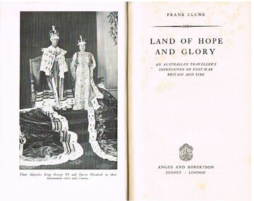
Book - ALEC H CHISHOLM COLLECTION: BOOK ''LAND OF HOPE AND GLORY'' BY FRANK CLUNE
Book. ALEC H CHISHOLM COLLECTION. 352 page hardcover book giving an account of Frank Clune's journey through England, Scotland and Ireland in 1947. Illustrated with B & W photographs. Published in 1949 by Angus & Robertson, Sydney and printed by Halstead Press, Sydney. Catalogue sticker ''2211 CLU'' on spine. Handwritten in ink on flyleaf '' To Alec Chisholm for his love of the Land of Hope and Glory Yours sincerely Francis Patrick Clune. Vaucluse xx/x/49''Frank Clunebooks, collections, travel, alec h chisholm collection, frank clune, travel, great britain -
Bendigo Historical Society Inc.
Document - ROYAL PRINCESS THEATRE COLLECTION: THE QUERIES, 21 April, 1920
Royal Princess Theatre - The Queries. Wednesday, April 21, 1920. Artists: Mrs Kavanah, Misses Mackay, McKenzie and Connell. Miss Dunstan, Connell, A Macoboy, and Jackson. Mr Casson, Miss Mackay, Mrs Kavanah. Programme: 'N Everything' 'Bobby Dear' 'Dixie-Land' 'Moonlight and Music' 'New York' 'Something Oriental' 'All Dressed Up' 'Passe Temps De Pierrot' 'Tom Jones' 'Some Dance' 'Toddle Along' 'Some Automobile' several song described as 'Selected'program, theatre, royal princess theatre, royal princess theatre - the queries. wednesday, april 21, 1920. artists: mrs kavanah, misses mackay, mckenzie and connell. miss dunstan, connell, a macoboy, and jackson. mr casson, miss mackay, mrs kavanah. programme: 'n everything' 'bobby dear' 'dixie-land' 'moonlight and music' 'new york' 'something oriental' 'all dressed up' 'passe temps de pierrot' 'tom jones' 'some dance' 'toddle along' 'some automobile' several song described as 'selected' -
 Bendigo Historical Society Inc.
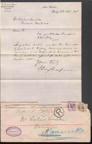
Document - CONNELLY, TATCHELL, DUNLOP COLLECTION: MR RICHARD COUCHER MORTGAGE
CONELLY & TATCHELL COLLECTION Mr Richard Coucher-Farmer re Mortgage - Purple two pence Victoria stamp and a yellow three pence on the envelope Letter from F Douglas Jones Barrister & Solicitor Albion Chambers Bendigo 22.4.1895 re payment of monies owing on mortgage .Also a document re Transfer of Land Act 1890 -Notice to pay monies owing on Mortgage to Richard Coucher of Tandarra Farmer .Please take notice that I ..James Weekley -
Bendigo Historical Society Inc.
Map - CAMPBELL COLLECTION: BENDIGO AND DISTRICT MAPS
Map. Bendigo Whipstick Forest Park, 1:75,000, reserved forest and crown land, highway main road access forest tracks. New Moon Mine, Elliot Dam, Nuggety Dam, Rogers Tree, Old Tom Mine, Blow Holes, Skylark Dam, Monument Rock, Hartland Eucalyptus Still and Dam, Hartland Eucalyptus Farm, Millwood Dam, Sandner Eucalyptus Still Site, Various unmarked dams. (number 391 in map cupboard 1)map, bendigo, country lands -
 Bendigo Historical Society Inc.
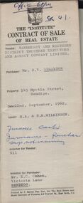
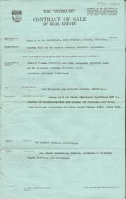
Document - H.A & S.R. WILKINSON COLLECTION: CONTRACT OF SALE
Contract of sale of real estate between Sandhurst and Northern District Trustees executors and Agency Company Limited (Vendor) and Mr. R.V. Sprawson (Purchaser). Dated 22nd, September, 1962. Solicitor for vendor: Nil. Solicitor for purchaser: Mr. E.C. Cohen, Victoria Lane, Bendigo. Sale of that piece of land being Crown allotment 4 section 10B described in Certificate of title volume 2757 folio 345 known as 145 Myrtle Street, Bendigo. Price 1,250 pounds.organization, business, h.a. & s.r wilkinson real estate -
 Bendigo Historical Society Inc.
Document - H. A. & S. R. WILKINSON COLLECTION: CONTRACT OF SALE
Contract of sale of real estate dated 11th June, 1964 between Miss B. Dunn (vendor) and Mr. E. T. Simmonds (purchaser). Solicitor for vendor: Watson, James & Rogers, Bull Street, Bendigo. Solicitor for purchaser: Schleiger & Smalley, Williamson Street, Bendigo. Property: 49 Hamlet Street, Bendigo being part of Crown allotment 9, section 108C land now remaining in Crown Grant volume 1576, folio 142. Price 1,100 pounds.organization, business, h.a. & s.r wilkinson real estate -
 Bendigo Historical Society Inc.
Document - H. A. & S. R. WILKINSON COLLECTION: CONTRACT OF SALE
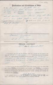
Conditions of sale of private contract dated 20th August, 1938 between G. Rasmussen (vendor) and E. Simmons (purchaser). Property: Freehold described in certificate of title volume 5514 folio 1102695, volume 1786 folio 357169, volume 5012 folio 1002400 transfer 1405137 and all buildings erected thereon. Being all that piece of land coloured purple on said map part of Crown allotment 392 and 393 section H City of Bendigo. Price; 680 pounds.organization, business, h.a. & s.r wilkinson real estate -
 Bendigo Historical Society Inc.
Document - H. A. & S. R. WILKINSON COLLECTION: CONTRACT OF SALE
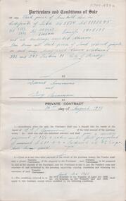
Conditions of sale of private contract dated 20th August, 1938 between G. Rasmussen (vendor) and E. Simmons (purchaser). Property: Freehold described in certificate of title volume 5514 folio 1102695, volume 1786 folio 357169, volume 5012 folio 1002400 transfer 1405137 and all buildings erected thereon. Being all that piece of land coloured purple on said map part of Crown allotment 392 and 393 section H City of Bendigo. Price; 680 pounds.organization, business, h.a. & s.r wilkinson real estate -
 Bendigo Historical Society Inc.
Document - CONNELLY, TATCHELL, DUNLOP COLLECTION: LEGAL PAPERS, 1890 - 1910
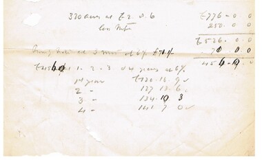
Document. Connelly, Tatchell & Dunlop - Legal Papers. 1 - Notes titled 'Crawfords land' 1902? 2 - 1890 - Torn notes - Commercial Finance Coy P? to Anderson. 3 - Torn Sheet - The Justices Act 1904, Third Schedule, Default Summons upon a complaint for a civil debt, in the court of Petty Sessions at Bendigo, in the Midland Bailiwick. 4 - Sundry General Costs concerning Custsons? R (name unreadable). 5 - Notes concerning 320 acres (notes not found).cottage, miners, connelly, tatchell & dunlop, commercial finance coy p?, anderson, the justices act 1904, custsons? r -
Tatura Irrigation & Wartime Camps Museum
Certificate of Title, Subdivisions, 1879 and 1930
Title Deeds for property in Tatura2 certificates of title showing subdivisions made over several years. Vol. 5655:Folio 1130935 dated 16/5/1930 and Vol.1182: Folio 236330 dated 23/12/1869. Lease between Thomas Hogan and W F Bazeley dated 7th July 1911 for land in Hogan Street known as Slaughter Yard Paddock .Also lease dated 1911. In buff coloured legal envelope with number "2678" and "Hogan - Thomas" written in red on outside.tatura, relationship folders, certificate of title, lease, thomas hogan, john hogan, john james hanlon, edward glover, arthur burke, james brady, andrew collie, jean hunter, sydney embling, john maher, arthur goyen, patrick o'toole, philipe dove, george wildon, edwin harden, cuthbert corke, lee chung, hugh barnes, george manning, francis williams, john fawkner, michael walshe, alexander ferguson, rose gullett, john gibb, william taylor, richard casey, anthony grover, arthur grover, charles brady, elizabeth davey, frank williams, honora culkin, alexander park, stephen reville, richard carr, charles grover, henry mccarthy, james bruce, edward hanley, chew yen, ah poy, loo way, ah dick, charles mitchell, lionel martin, douglas forsyth, catherine wilson, mabel heath, patrick mcnamara, micheal cussen, james wilson, bazeley, documents, legal -
Whitehorse Historical Society Inc.
Legal record - Land Title, Musk Street, Blackburn
Land Titles referring to No. 1 Musk Street, BlackburnLand Titles referring to No. 1 Musk Street, Blackburn : 1. Vol. 542 Fol. 108222, James William Barnes, 1872; 2. Vol. 1877, Fol. 375367, Freehold Investment and Banking Company of Australia Limited, 1886; 3. Transfer 1507851 to John Thomas Williams, 1932; 4. Vol. 8109 Fol. 997 William Henry Rogers, 1955, with Plan of Subdivision CP 21670; 5. cadastral map, AMA zone 55, Sep 2000.Land Titles referring to No. 1 Musk Street, Blackburn musk street, blackburn, no. 1, maple street, blackburn, lawson street, blackburn, elder street, blackburn, barnes, james william, freehold investment and banking company of australia ltd, springfield road, blackburn, whitehorse road, blackburn, barnes estate