Showing 29615 items
matching hill
-
 Camberwell Historical Society
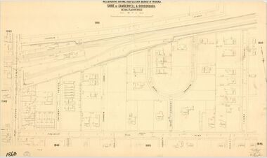
Map (Item) - MMBW map, Melbourne and Metropolitan Board of Works, Melbourne and Metropolitan Board of Works - Shire of Boroondara and Camberwell - Detail Plan no. 1860, August 1904
Lithographer E.H.H., Exd J.W.D, June 1904, No. 70. 40P.15W.melbourne and metropolitan board of works, map, camberwell, cartography -
 Stawell Historical Society Inc
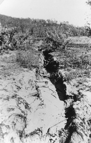
Photograph, Bushfire damage showing Soil Erosion 1939
Scene showing soil erosion after 1939 bushfire. Black and white photograph of a ravine down the side of a hill. The erosion has resulted from the 1939 bush fire.stawell -
 Clunes Museum
Photograph
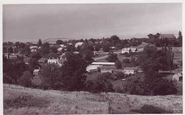
BLACK & WHITE PANORAMIC VIEW OF CLUNES TAKEN FROM SCENIC ROAD LOOKING TOWARDS TWO MILE HILLlocal history, photography, photographs, clunes township -
 Bendigo Historical Society Inc.
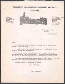
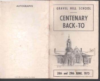
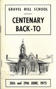
Document - RANDALL COLLECTION: GRAVELL HILL SCHOOL CENTENARY BACK- TO 1875 - 1975, 1875-1975
Documents, Gravel Hill School Centenary Back-to 1875- 1975, people who attended. 21 separate pages .bendigo, buildings, gravel hill school -
 Bendigo Historical Society Inc.
Document - RANDALL COLLECTION: GRAVEL HILL SCHOOL, 28-29 June 1975
Document, Gravel Hill School Centenary Back-to, Booklet, 28th and 29th June 1975.Approx. 36 pages.Cambridge Press, Bendigo.bendigo, buildings, gravel hill school -
 Bendigo Historical Society Inc.
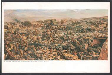
Document - AUSTRALIAN WAR MEMORIAL PAINTING TOBRUK POSTCARD
Postcard: coloured postcard painting of 'C' Company raid on Carrier Hill, 22nd. April 1941 by Ivor Hele.postcard, carrier hill tobruk, 'c' company, postcard -
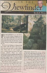 Bendigo Historical Society Inc.
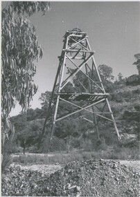
Newspaper - JACK PERRY COLLECTION: NEWSPAPERDIAMOND HILL, STAFFORD MINE, WATER WHEEL
Newspaper article Bendigo Weekly. Mentions Diamond Hill and Golden Gully, Phillips Water Wheel, Stafford Mine.person, individual, jack perry - diamond hill, diamond hill, phillips water wheel -
 Bendigo Historical Society Inc.
Document - BENDIGO HISTORICAL SOCIETY: THE RICH VICTORIA HILL NOTES AND PHOTOS, Unknown
BENDIGO HISTORICAL SOCIETY: The Rich Victoria Hill Notes and Photos courtesy A Richardson 29 Harrison St Bendigobendigo, history -
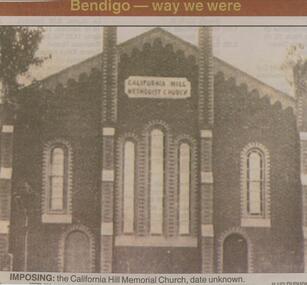 Bendigo Historical Society Inc.
Newspaper - JENNY FOLEY COLLECTION: IMPOSING
Bendigo Advertiser ''The way we were'' from 2001. Imposing: the California Hill Memorial Church, date unknown.newspaper, bendigo advertiser, the way we were -
 Bendigo Historical Society Inc.
Document - LUCY HILL COLLECTION: AUSTRALIAN FOLK LORE AND THE UMBIQUITOUSE GOAT, 1860-1951 approx
Articles by Lucy Hill: AUSTRALIAN FOLK LORE AND THE UMBIQUITOUSE GOAT Stories of the goats that used to roam around Bendigodocument, lucy hill collection - compiled by john hattam from the manuscript of the late lucy hill and published in the bendigo advertiser -
 Bendigo Historical Society Inc.
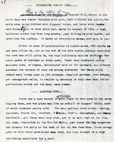
Document - LUCY HILL COLLECTION: BULLDOZING DIAMOND HILL, 1952
Typed notes about the history of Diamond Hill and the bulldozing ot fill in the shafts in January 1952 for five months.document, gold, diamond hill, lucy hill collection -
 Bendigo Historical Society Inc.
Photograph - ARGUS HILL MINE: CHEWTON, 1964
black and white photo: abandoned poppet head, hillside in background. Argus Hill Mine Chewton. RHSV stamp.Alan Doney ( James Lerk, 10.2000 )organization, business, argus hill mine, chewton -
 Bendigo Historical Society Inc.
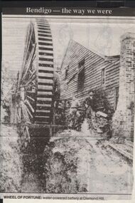
Newspaper - JENNY FOLEY COLLECTION: WHEEL OF FORTUNE
Bendigo Advertiser "The way we were" from 1999. Wheel of fortune: water powered battery at Diamond Hill.newspaper, bendigo advertiser, the way we were -
 Bendigo Historical Society Inc.
Book - GRAVEL HILL SCHOOL CENTENARY BACK-TO, 1975
Gravel Hill School, Centenary Back-To 28th and 29th. June 1975. 34 pages. With photographs, illustrations, maps.bendigo, education, gravel hill primary school, bendigo, education, gravel hill primary school. centenary. -
Bendigo Historical Society Inc.
Book - THE SCHOOL ON THE HILL BENDIGO HIGH SCHOOL 1907 - 1982, 1982
THE SCHOOL ON THE HILL BENDIGO HIGH SCHOOL 1907 - 1982 40 pages with photographs and illustrations. Gold cover. With Index.Janette E. Bomfordbendigo, education, bendigo high school, bendigo, bendigo high school, education, janette bomford. -
Bendigo Historical Society Inc.
Document - BASIL MILLER COLLECTION: TRAMS - TIME TABLE - TURN BACKS
Handwritten timetable headed 'Turn Backs Easter Saturday', listing the turnaround times for Eaglehawk/Quarry Hill Line.person, individual, basil miller -
 Bendigo Historical Society Inc.
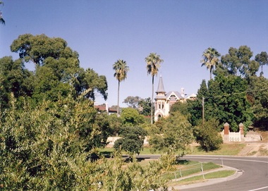
Photograph - THE EYRIE, c2001
Color Photograph. 'The Eyrie' Reginald St., Quarry Hill, taken April 2001. Physical Description: Unmounted photo.Willa, Wendybuildings, residential, the eyrie, gordon & wendy willa, deakin street, lockington -
 Bendigo Historical Society Inc.
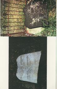
Photograph - FRIENDS OF WHITE HILLS CEMETERY COLLECTION: COPY OF PHOTOGRAPH
Photograph. Copy of photograph of JENSEN and KLUNDER headstones before and after restoring to upright position at White Hills Cemetery.photograph, landscape, copy of headstones -
 Bendigo Historical Society Inc.
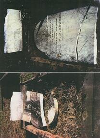
Photograph - FRIENDS OF WHITE HILLS CEMETERY COLLECTION: COPY OF COLOURED PHOTO
Photograph. Copy of a coloured photograph of SEWELL headstone before and after restoring to upright position at White Hills Cemetery.photograph, landscape, copy of sewell headstone -
 Bendigo Historical Society Inc.
Postcard - ROY AND DORIS KELLY COLLECTION: MAINZ PANORAMA, GERMANY, POSTCARD, 1900-1920
Postcard, coloured photo of a panoramic view of the city of Mainz in Germany. Showing the roofs of buildings and low hills in the distance.postcard, photograph, postcard, mainz, germany -
Bendigo Historical Society Inc.
Map - SANDHURST (PART), Circa 1880's
Map: Parish plan sowing an area along Specimen Hill Rd. ( number 211 in Map Cupboard 1)map, bendigo, parish plan, specimen hill rd. sandhurst , bendigo -
Bendigo Historical Society Inc.
Map - EAGLEHAWK (PART), 22/01/1882
Map: Parish plan showing area Eastward from Lightning Hill ( number 205 in Map Cupboard 1)map, bendigo, parish plan, eaglehawk, lightning hill -
 Bendigo Historical Society Inc.
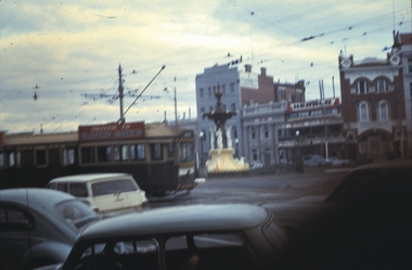
Slide - BENDIGO TRAMS, June 1970
Slide. Bendigo Trams. Green/cream longer tram heading along Mitchell Street, towards Quarry Hill.slide, bendigo, bendigo trams., bendigo trams. -
Stawell Historical Society Inc
Painting, Nancy Rutter, "The Old Gum Tree" Painting by Nancy Rutter
Nancy Rutter Local ArtistArtists Card Australian landscape with Hills in Distance Two mid distance broke dead branch in left foregroundNancy Rutter The old Gum Tree Oil. on Rear of Painting along with information on Card Maker,australian landscape -
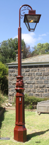 Flagstaff Hill Maritime Museum and Village
Functional object - Lamp Light, late 19th - early-20th century
This gas lamp light and stand came from the original manufacturer in Melbourne. Gas street lights such as this one were used in Melbourne from the mid-19th century. The lights enabled safer after-dark travel for pedestrians and vehicles and were a deterrent to crime. A lamp lighter was employed to keep the lamps lit, sometimes with little success due to weather conditions and the pranks of youths. WARRNAMBOOL Gasworks In Warrnambool prior to 1874 there were about twenty rare, individually lit street lights in Warrnambool, each with its own supply of kerosene. These lamps were in the central business area of Timor, Koroit and Liebig Streets. The Warrnambool Gas Company Ltd. was registered as an incorporated company in 1873. It was a private, locally owned business. It was located at 209-215 Merri Street, Warrnambool, on the land, which is just west of the later-built railway station. The first managers of the Gas Company lived in a substantial stone house on site, but later the managers lived in a residence in Henna Street between Merri and Timor Streets. The original home, which still stands, became a residence for the Railway Station Master from about 1890. In August 1874 the construction of the gasworks was complete and at the end of that month gas was supplied to all of the existing lamps in Warrnambool for the first time. The Warrnambool Gas Company wound up in 1880-1881 and was purchased by the Warrnambool Borough Council with money raised by a loan – the Borough’s first ‘loan transaction’. The Council established a piped network to supply gas to other street connections. The gasworks were privatised and upgraded in 1952. In 1972 the town supply was converted to liquid petroleum gas and by the early 1980s the gasworks were closed down. In 1986 Warrnambool was supplied with natural gas from a site near Port Campbell. The Warrnambool gasworks supplied all street and shop lighting and most domestic lighting until 1923 when electricity was available for lighting. Bromfield Street in Warrnambool was named after the director of the gasworks, James Astley Bromfield (1823-1903). He arrived in Warrnambool from Worcestershire, England, in 1852 and was very active in the local council and community. Cockman Street was named after the first secretary of the gasworks in 1874, Walter Cockman (c.1821-1892). He was a Mayor and businessman. The second Manager, Luther Rodgers, worked for the gas company for about twenty years and both Rodger Place and Rodgers Road in Warrnambool have been named after him. LAMP LIGHTS IN MELBOURNE In the 1820s Melbourne's innkeepers were legally required to have a lamp light outside their premises from sunset to sunrise. This was the first instance of street lamps being used in Melbourne. In 1847 the first oil lamp was used in the city. In 1849 a gas lamp was installed on the Swanston Street Bridge and much of the city had oil lamps installed by then. In August 1857 the installation of street gas lamps began in Melbourne. They were welcomed for the much brighter illumination they gave. By 1860 there were 414 lamp pillars. The phrase was quoted often - "A light was as good as a policeman". The first gas burners used for street lighting were called 'fishtail' gas burners. These were replaced in the early 1900s by gas mantles. The City of Melbourne Gas Coke Company was formed in 1850 but due to the Gold Rush the manufacture and distribution of the gas supply was delayed until January 1856. By the 1890s the gas supplying the lights was supplied by three companies in Melbourne. In 1879 a football match was played at the MCG under electric lighting and gradually electric arc lights were installed inside and outside buildings in the city. Lamp lights such as the one in Flagstaff Hill’s collection were no longer needed. (References: John Lindsay re Lamp Light history 2019-01-29, Former Warrnambool Gas Company Limited, Victorian Heritage Database Report, Heritage Number 149746 https://vhd.heritagecouncil.vic.gov.au/places/149746/download-report ) The lamp light is representative of the lamps used in Melbourne from the mid-nineteenth century to light the streets at night and make Melbourne a safer city. The lamp is also representative of the gas street lighting in Warrnambool from the mid-1870s-1920s.Lamp light or gas light. Street light, one of the last gas street lights removed from Melbourne. (Reconditioned by Friends of Flagstaff Hill, 2013)flagstaff hill, warrnambool, shipwrecked coast, flagstaff hill maritime museum, maritime museum, shipwreck coast, flagstaff hill maritime village, great ocean road, lamp light, gas light, gas lamp, street lamp, street light, gas street light, melbourne street lighting, warrnambool street lighting, melbourne gas street light, warrnambool gas company, warrnambool gasworks, james bromfield, walter cockman, luther rodgers, city of melbourne gas coke company -
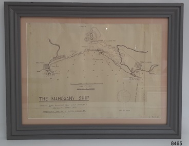 Flagstaff Hill Maritime Museum and Village
Document - Location Chart, The Mahogany Ship, 2007
This chart shows a possible site for the fabled wreck called the 'Mahogany Ship'. Flagstaff Hill’s collection includes other objects that some say could be relics from this Ancient Wreck, (also called the Gold Ship, or the Ancient Vessel). The chart shows the coordinates for the Summits of Griffith Island and of Middle Island. It also has the depths of the sea at various intervals and shows the shore and sand dunes, lighthouses and other reference points. The mystery of the Mahogany Ship began in 1836 when two shipwrecked sealers discovered the remains of an “ancient vessel” in the sand dunes about four miles west of Warrnambool. Since the last recorded sightings in the 1880’s the true origin of the Mahogany Ship has remained one of Australia’s most famous historical mysteries or fables. One of the more recent theories is that the vessel was one of the Portuguese ships exploring the Australian coast in 1522. For over one hundred years searchers have attempted to locate and identify the wreck. The search continues for the tangible evidence which will once and for all establish the Mahogany Ship’s place in Australia’s History.The chart represents the worldwide interest in locating the wreck of the Mahogany Ship. Locating the actual wreck or proving the existence of a Portuguese ship's wreck could change the history of the discovery of Australia. A Mahogany Ship committee was formed to gather and research information about the discovery of the wrecked ship. A large amount of money was offered as a prize for finding the wreck or parts of it. People have written books, painted images, made videos and told tales of the ship but it continues to remain a mystery or even a fable. The chart is significant for its possible link to one of Victoria’s and Australia’s maritime mysteries, the Mahogany Ship (also known as the Ancient Wreck). It is one of very few known relics that could give evidence of the existence and history of the vessel. It is listed on the Victorian Heritage Register S438 as it is one of Victoria’s oldest recorded shipwrecks. The identity of the vessel has the potential to change Australia’s history.A chart in a wooden frame, behind glass. The chart shows the approximate position of the mystery Ancient Wreck, later called the "Mahogany Ship". The chart is a copy and is based on the Admiralty Chart by Lieut. Stanley, dated 1872. Lower left: "THE MAHOGANY SHIP" "LOCALITY PLAN, ENLARGED FROM LIEUT. STANLEY'S ADMIRALTY CHART 1872" "APPROXIMATE POSITION OF WRECK MARKED [symbol of a Portuguese cross]" Other labels on chart: "BELFAST" "PORT FIARY" "GRIFFITHS I" "RIVER MOYNE" "RIVER MERRI" "ARMSTRONG BAY" " GORMANS LANE" "TOWER HILL" "KOROIT" "HELEN ROCK" "WARRNAMBOOL" "LADY BAY" "MIDDLE I" "LIGHT HO." Lower right: "G 410 B" Label on the back; "This chart presented to the Mahogany Ship Committee and Flagstaff Hill by Avis Quarrell, April 2007"warrnambool, shipwrecked coast, flagstaff hill maritime museum, shipwreck coast, mahogany ship, ancient vessel, ancient wreck, portuguese ship, coastal reserve, fabled wreck, gold ship, griffiths island, belfast (now port fairy), koroit, location plan, leuit. stanley, admiralty chart 1872, tower hill, merri river, moyne river, middle island, helen rock, armstrong bay, griffiths land -
 Orbost & District Historical Society
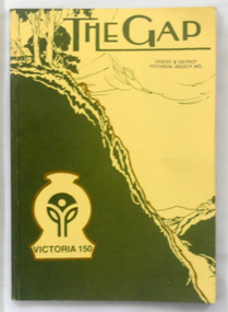
magazine, The Gap -1985
This is a special edition of The Gap to celebrate 150 years of Victorian settlement. The first edition of this magazine was produced by associated elementary schools in the Omeo Shire. The magazine was published from 1920 to 1927 and 1963 to 1969. This is a special issue in 1985. In all issues there is writing by children from schools that have since closed down.This item reflects the changes in education in East Gippsland and is a useful comparison tool for literacy teaching. It also has historical articles for research.A 174 pp magazine with an olive green and cream coloured cardboard cover. On the front is a sketch of a small schoolhouse on a hill overlooking a gap in the hills below. The title, "The Gap" is at the top in green print on a cream background. There is a logo for Victoria 150. It contains historical articles, photographs and examples of children's work. -
 Orbost & District Historical Society
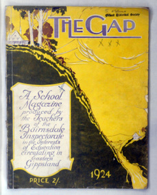
magazine, Keating Wood Pty Ltd, The Gap 1924, 1924
The first edition of this magazine was produced by associated elementary schools in the Omeo Shire. The magazine was published from 1920 to 1927 and 1963 to 1969. There was a special issue in 1985. In all issues there is writing by children from schools that have since closed down. This is the fifth issue.This item reflects the changes in education in East Gippsland and is a useful comparison tool for literacy teaching. It also has historical articles for research.Two copies of a magazine with an olive green and yellow coloured cardboard cover. On the front is a sketch of a small schoolhouse on a hill overlooking a gap in the hills below. The title, "The Gap" is at the top in mauve print and at the bottom "1964". The cost is noted as 2/-. It contains historical articles, photographs and examples of children's work. . magazine-the-gap education omeo -
 Whitehorse Historical Society Inc.
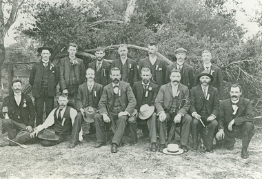
Photograph, Picnic, C1905
Black and white photo of men at picnic from the Australian Tesselated Tile Company. Dressed in cricket gear? Reporter Wardrop trophy banner shown reflects support given by Box Hill business houses at the time. Local cricket competition still named Box Hill Reporter to this day.australian tesselated tile co. pty ltd, walker, edgar edwardes -
 National Vietnam Veterans Museum (NVVM)
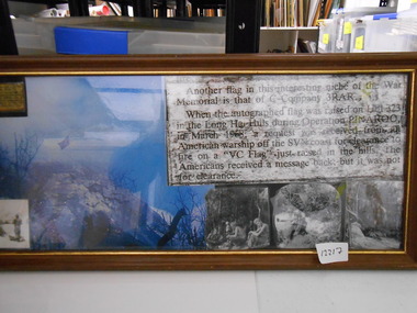
Photograph - Photograph, Collage, VC Flag
Framed Collage of C Company 3 RAR raised autographed Australian flag on Hill 323 in the Long Hai Hills during Operation Pinaroo in March 68. A request was received from an American Warship off the Coast to fire upon a newly raised "VC Flag". No clearance was givenc coy 3 rar, operation pinaroo, long hai hills, hill 323