Showing 24370 items
matching matthew-creek
-
 Hume City Civic Collection
Photograph, c 1980s
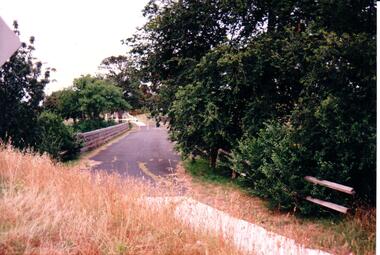
The stone bridge was the only entry into Sunbury on the eastern side of the town and was in use until the road was re-routed and widened in the 1970s.A coloured photograph of the roadway over the Macedon Street bridge which spans Jacksons Creek. There is a grassy area in the foreground with trees growing either side of the bridge. The narrow asphalted surface of the road across the bridge is cut off by a low stone wall.stone bridges, jacksons creek, macedon street road bridge, george evans collection -
 Hume City Civic Collection
Photograph, early 1980s
The photograph shows the extent of Sunbury's development to the west of the town in the early 1980s. The settlement at this stage extended along either side of Gap Road for about 0.5 km beyond Elizabeth Drive.A coloured landscape photograph with rounded corners taken from Mt. Holden and looking towards the expanding town of Sunbury. The Melba Avenue drain which flows into Blind Creek is in the foreground. Sheoak Hill, the site of the former Sunbury Asylum is in the middle of the skyline.sunbury township, reservoir road, mt. holden, sunbury asylum, george evans collection -
 Sunshine and District Historical Society Incorporated
Map (1967), CITY OF SUNSHINE, June 1967, 1967
The City of Sunshine no longer exists. Part of the eastern area has been annexed by the City of Maribyrnong, and the rest of the old City of Sunshine has been amalgamated with the City of Keilor to form the larger City of Brimbank.This 1967 map is a historical record of the City of Sunshine as it existed 27 years before the amalgamation of Councils, and the creation of the City of Brimbank in 1994.Whitish paper map with black printing that is laminated in clear plastic film, and has a wood slat attached to the top edge. The June 1967 map is of the previous CITY OF SUNSHINE showing City and Parish boundaries, streets, railways, creeks, river etc.Purple ink stamps at top left hand and right hand areas showing address and contact details of 'Sunshine Industrial Promotion Centre.'city of sunshine, june 1967, map, city, parish, boundaries, brimbank -
 Stawell Historical Society Inc
Accessory - Jewellery
1930's Collection of seven items of costume dress jewelry belonging to Mary and Margaret Devery of Greens Creek Two bracelets, two clips for Dresses or Shoes,. Jewelry Accessory (part), Hair Coombe and Flower Broach in two cardboard boxes.clothing -
Whitehorse Historical Society Inc.
Map, Dandenong Ranges area. Sheet 7, c1957
Detailed map covering area from Mitcham and Vermont to Ringwood and Heathmont.Detailed map covering area from Mitcham and Vermont to Ringwood and Heathmont. Shows streets, block boundaries, buildings, railway and creeks. Note says prepared from State Aerial Survey, April 1954 and Cadastrial Survey information July 1956.Detailed map covering area from Mitcham and Vermont to Ringwood and Heathmont. maps, mitcham, vermont, ringwood, heathmont -
 Southern Sherbrooke Historical Society Inc.
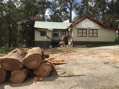
Photograph - Menzies Creek Hall damaged by storm, 2016
Colour photographs of Menzies Creek Hall damaged by a falling tree during a wind storm, 10th October 2016. In the first photo several cut logs in the foreground. The second photo shows a room bisected by the tree. Photos taken by Marian Matta. -
 Southern Sherbrooke Historical Society Inc.
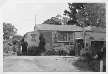
Photograph - Menzies Creek Post Office, 1968
Photograph of Menzies Creek Post Office and General Store on the Belgrave-Gembrook Rd. Shows narrow flight of stairs to doorway. In front of store is a telephone box and a bus shelter, Many trees visible in background. Photo from National Archives of Australia. -
 Southern Sherbrooke Historical Society Inc.
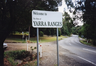
Photograph - Photo, temporary shire sign. Shire of Yarra Ranges
Colour photograph of entrance to Menzies Creek looking west, showing the new temporary Shire sign after amalgamation of Victoria's council areas in 1995. Belgrave-Gembrook Rd with Menzies Rd going to the left. Photo taken in 1995 by Marian Matta. -
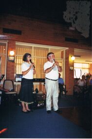 Bendigo Historical Society Inc.
Photograph - PETER ELLIS COLLECTION: EMU CREEK BUSH BAND, 25th November, 2007
Colour photograph. Emu Creek Bush Band playing in hall. Blue carpet. Marg Hogan and Peter Ellis playing recorder. Back of photo reads: Bendigo Retirement Village Sunday Nov. 25th 2007 Margaret Hogan Peter Ellis.entertainment, music, emu creek bush band -
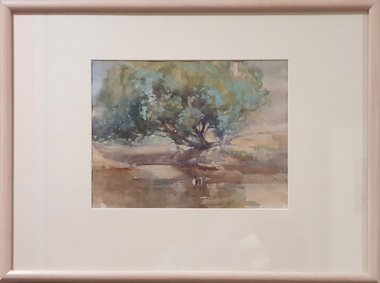 Federation University Art Collection
Painting - Watercolour, McGeorge, Norman, Untitled, c mid 1940s
Norman MacGEORGE (08 July 1872– 2 September 1952) Born Adelaide, South Australia Norman Macgeorge taught drawing at Wesley College, Melbourne from 1902-06. He also taught at Melbourne Teachers' College and at Melbourne Church of England Grammar School. This item is part of the Federation University Art Collection. The Art Collection features over 2000 works and was listed as a 'Ballarat Treasure' in 2007.Framed landscape depicting the confluence of the Darebin Creek and the Yarra River. Purchased by the Ballarat Teachers' College in 1964. This work was exhibited in "Norman MacGeorge: Man of Art" at the Ian Potter Museum of Art, The University of Melbourne, 22 September to 25 November 2001.art, artwork, norman mcgeorge, mcgeorge, watercolour, available, landscape, darebin creek, yarra river, ballarat teachers' college art collection -
Tarnagulla History Archive
Compilation file: The Dunolly, Tarnagulla and St Arnaud Express and The Dunolly & Burnt Creek Express - Tarnagulla references, 1860 on and 1862 - 1863
David Gordon Collection. A black plastic folio containing many pages of photocopies from Dunolly, Tarnagulla and St Arnaud Express newspaper (1863 - ) and The Dunolly & Burnt Creek Express newspaper (May 1862 - August 1863) - all which reference Tarnagulla in some way. newspapers -
Tarnagulla History Archive
Article - News article: John Heather on Penny Farthing, c. 1960s
Williams Family Collection. Small news clipping with title 'The Cover'. Discusses John Heather riding a Penny Farthing on his Murphy's Creek farm. Also that the bike previously belonged to Herman Bock, who purportedly rode it from Tarnagulla to Bendigo before there were roads. tarnagulla -
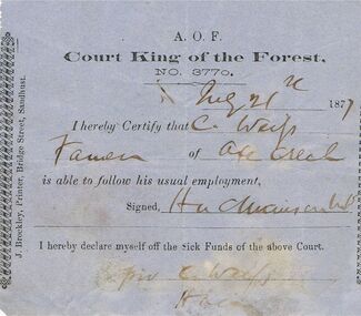 Bendigo Historical Society Inc.
Document - ANCIENT ORDER OF FORESTERS NO 3770 COLLECTION: DOCTOR'S CERTIFICATE
Blue Doctor's Certificate dated Aug 21st, 1877, certifying that Christian Weip of Axe Creek was able to follow his usual employment. Signed by H. L. Atkinson. Signed at the end by Christian Weip declaring himself off the Sick Funds.societies, aof, correspondence, ancient order of foresters no 3770 collection - doctor's certificate, court king of the forest, christian weip, h l atkinson, j brockley -
 Eltham District Historical Society Inc
Photograph, Eltham - Floods in 1934
To the left of picture is the Main Road Bridge over the Diamond Creek in Eltham South when the Diamond Creek was in flood. The Yarra also was in flood. In early December 1934 the "Greatest flood in the history of the Yarra" occured, according to The Argus newspaper. Bridges and houses were swept away with hundreds of people left homeless across the state. The historic 1934 flood of the Diamond Creek and Yarra River set the criteria for future planning with respect to flood water rise.This photo forms part of a collection of photographs gathered by the Shire of Eltham for their centenary project book, "Pioneers and Painters: 100 years of the Shire of Eltham" by Alan Marshall (1971). The collection of over 500 images is held in partnership between Eltham District Historical Society and Yarra Plenty Regional Library (Eltham Library) and is now formally known as 'The Shire of Eltham Pioneers Photograph Collection.' It is significant in being the first community sourced collection representing the places and people of the Shire's first one hundred years.Digital image 4 x 5 inch B&W Negsepp, shire of eltham pioneers photograph collection, eltham, diamond creek (river), 1934 flood, diamond creek, floods, main road bridge -
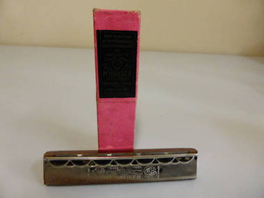 Warrnambool and District Historical Society Inc.
Musical Instrument, Mouth Organ and Box, Early 20th century. The Trade mark sign has circle being held by two hands has star inside which would indicate that it was before WW2
Matthew Hohner began manufacturing mouth organs in 1857 in Germany and became quite popular over the ensuing years with production reaching over 1 million units in the 1880’s. Control of the business passed to his sons around 1900. By 1920 the company was producing 20 million harmonicas a year. They sold to both sides of the conflict during the first world war. Other musical instruments were made by the company in the 20th century. Ernst Hohner retired from the firm in 1965 after 45 years at the healm. Harmonicas and mouth organs were mass produced in the later part of the 19th and into the 20th century and as such are items with which many people can identify. It has social and cultural significance. The harmonica has chrome top and bottom with wooden section in middle. Box is bright pink with label depicting a musical band in tones of orange and black.Harmonica has Jazz band and Made in Germany engraved on the top. The bottom has engravings M Hohner, Trade Mark Made in Ulm 1873.mouth organ, hohner mouth organ, warrnambool -
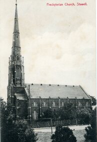 Stawell Historical Society Inc
Photograph, St. Matthew’s Presbyterian Church
St. Matthew’s Presbyterian Church Stawell. Now United Church. This landmark of Stawell was opened on 11th April 1869. The tower and spire, overall height of 148 feet, cost 1352 pounds and was paid for by an early mine owner. In March 1869, a month before the Church was opened, the local paper reported that a large red flag on the top of the Presbyterian Spire meant that the last brick had been laid and the massive gilt ball and cross had been placed in position. The Church has some fine stained-glass windows. Two identical side views of a church with a tall steeple. These photos were taken from the original Post Cards in Album 13, p.41. The photo shows a Tennis Courts in foreground with a picket fence around the church. Presbyterian Church, Stawell written on the front of the post card and June' 09 Stawell written in pencil on the back. Post cards printed in Germany.stawell religion -
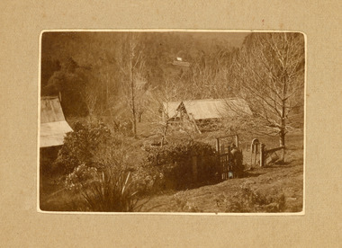 Mt Dandenong & District Historical Society Inc.
Photograph
The photograph belonged to Frank Child and shows the homestead belonging to his grandparents Ted and Ethel Child situated on Childs Road at Kalorama. Francis Matthew (Frank) Child (1928 – 2020) was the son of Bernard Child (1907 – 1995). Bernard was the son of Ethel May Madden and an unknown father. When Ethel married Ted Child in 1908 Bernard was raised by Ted’s parents Francis and Martha Child. Bernard married Dulcie Paice (1904 – 1990) and they had one son, Frank Child, before they divorced in 1943.Small sepia photograph showing a woman entering the gateway to a homestead. The trees have lost their leaves and their are shrubs along the fence line. Two sheds can be seen to the right with a homestead roof to the left.Handwritten on reverse: Home of Ethel + Ted Child Childs Rd Kaloramafrank child, ted child, ethel child, childs road, kalorama, homestead -
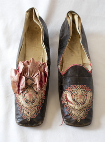 Brighton Historical Society
Shoes, circa 1867
These shoes were worn by Emily Cock (nee Smith), the daughter of wealthy early settler John Matthew Smith. From 1856 until 1931 the Smiths lived at 'Castlefield', a mansion on a vast estate that at one time stretched along South Road from Bluff Road to Hampton Street. The land was gradually subdivided, and the house is now a part of Haileybury College. Julien Mayer was a French ladies shoemaker and prolific exporter who advertised his successes on the shoes themselves by stamping the soles with details of the prizes he had won.Pair of black kid leather shoes with low block heel, decorated with pink silk, cut-away applique and embroidery. Pink bow with metal clasp on one shoe; missing from the other. Edged with pink silk ribbon binding, largely deteriorated.Sole embossed with "MAYER / Julien / à Paris", in addition to tamped with three small medallions proclaiming the awards the shoemaker won in London in 1862, Porto in 1865 and Paris in 1867. Handwritten in interior sole of T0124.2 in pencil: "Emily Smith / Castlefield"emily smith, castlefield, shoes, 1860s, applique, embroidery, julien mayer -
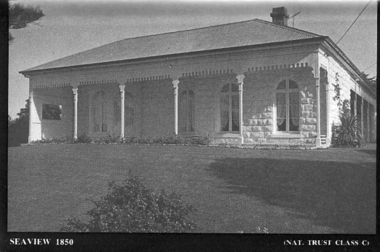 Port Fairy Historical Society Museum and Archives
Souvenir - Postcard, Seaview 1850
The construction of Seaview commenced in 1860, after David Talbot, purchased the land from James Atkinson,It had been suggested that it was intended to be double storied but there is no evidence of how that would have been accomplished. Following Talbot’s insolvency, Michael O’Reilly leased the house in 1862 until 1876 when he left for Melbourne.William Powling (Solicitor) acquired the house for Eight hundred and twenty three pounds in 1890 and lived there the rest of his life. His son Ernest Powling continued living there before selling it to Matthew Cathcart in 1917.A black and white photograph of the house called Seaview to be used as a postcard in a series by the National Trust Front of Seaview showing bay window and verandah bluestone painted whiteSeaview 1850 - Nat.Trust. CL1souvenir, port-fairy, seaview, powling, cathcart, talbot, o’reilly, house -
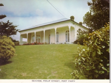 Port Fairy Historical Society Museum and Archives
Postcard, Seaview Philip Street Port Fairy
The construction of Seaview commenced in 1860, after David Talbot, purchased the land from James Atkinson,It had been suggested that it was intended to be double storied but there is no evidence of how that would have been accomplished. Following Talbot’s insolvency, Michael O’Reilly leased the house in 1862 until 1876 when he left for Melbourne.William Powling (Solicitor) acquired the house for Eight hundred and twenty three pounds in 1890 and lived there the rest of his life. His son Ernest Powling continued living there before selling it to Matthew Cathcart in 1917.Coloured photograph of Front of Seaview showing bay window and verandahsouvenir, port-fairy, seaview, philip street, house -
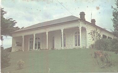 Port Fairy Historical Society Museum and Archives
Photograph
The construction of Seaview commenced in 1860, after David Talbot, purchased the land from James Atkinson,It had been suggested that it was intended to be double storied but there is no evidence of how that would have been accomplished. Following Talbot’s insolvency, Michael O’Reilly leased the house in 1862 until 1876 when he left for Melbourne.William Powling (Solicitor) acquired the house for Eight hundred and twenty three pounds in 1890 and lived there the rest of his life. His son Ernest Powling continued living there before selling it to Matthew Cathcart in 1917.Coloured photograph of White painted stone house with bay window to right and large verandahcottage, building, home, house, seaview -
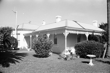 Port Fairy Historical Society Museum and Archives
Negative - Photograph
The construction of Seaview commenced in 1860, after David Talbot, purchased the land from James Atkinson,It had been suggested that it was intended to be double storied but there is no evidence of how that would have been accomplished. Following Talbot’s insolvency, Michael O’Reilly leased the house in 1862 until 1876 when he left for Melbourne.William Powling (Solicitor) acquired the house for Eight hundred and twenty three pounds in 1890 and lived there the rest of his life. His son Ernest Powling continued living there before selling it to Matthew Cathcart in 1917.negative, seaview, house -
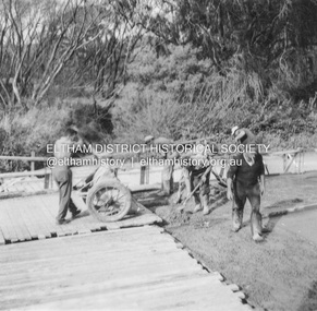
 Eltham District Historical Society Inc
Album - Photograph, J.A. McDonald, Eltham-Yarra Glen Road, 26 Jan. 1956
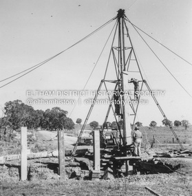
Watsons Creek Showing steel work 26/1/1956Record of various Shire of Eltham infrastructure works undertaken during the period of 1952-1962 involving bridge and road reconstruction projects, sometimes with Eltham Shire Council Project Reference numbers quoted. It was during this period that a number of significant improvements were made to roads and new bridges constructed within the shire that remain in place as of present day (2022). In many situations, the photos provide a tangible visible record of infrastructure that existed throughout the early days of the Shire. The album was put together by or under the direction of the Shire Engineer, J.A. McDonald.infrastructure, road construction, shire of eltham, bridge construction, eltham-yarra glen road, w.e. wolf, watsons creek, 1956-01-26 -
 Eltham District Historical Society Inc
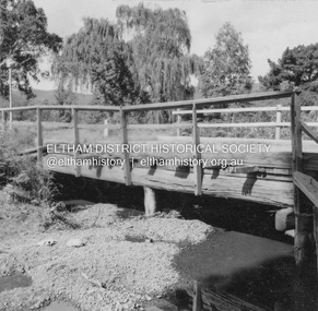
Album - Photograph, J.A. McDonald, Old Healesville Road, Sep. 1958
Paul Creek Road September 1958 Showing west abutmentRecord of various Shire of Eltham infrastructure works undertaken during the period of 1952-1962 involving bridge and road reconstruction projects, sometimes with Eltham Shire Council Project Reference numbers quoted. It was during this period that a number of significant improvements were made to roads and new bridges constructed within the shire that remain in place as of present day (2022). In many situations, the photos provide a tangible visible record of infrastructure that existed throughout the early days of the Shire. The album was put together by or under the direction of the Shire Engineer, J.A. McDonald.infrastructure, shire of eltham, bridge construction, road construction, old healesville road, paul creek road, 1958-09 -
 Eltham District Historical Society Inc
Album - Photograph, J.A. McDonald, Yarra Glen-Glenburn Road, Nov. 1956
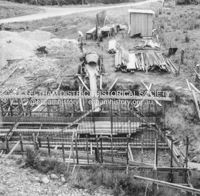
Cylinder foundation – Jehosophat Creek Showing flume – March 1956Record of various Shire of Eltham infrastructure works undertaken during the period of 1952-1962 involving bridge and road reconstruction projects, sometimes with Eltham Shire Council Project Reference numbers quoted. It was during this period that a number of significant improvements were made to roads and new bridges constructed within the shire that remain in place as of present day (2022). In many situations, the photos provide a tangible visible record of infrastructure that existed throughout the early days of the Shire. The album was put together by or under the direction of the Shire Engineer, J.A. McDonald.infrastructure, shire of eltham, 1956-03, bridge construction, jehosophat creek, road construction, yarra glen-glenburn road -
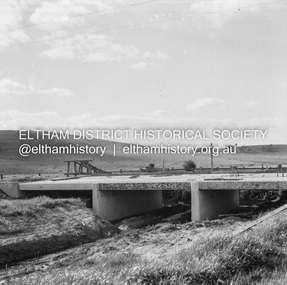
 Eltham District Historical Society Inc
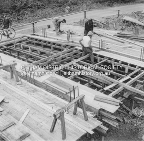
Album - Photograph, J.A. McDonald, Yarra Glen-Glenburn Road, May 1957
Jehosophat Creek – 56M295 May 1957 Preparation for Deck pourRecord of various Shire of Eltham infrastructure works undertaken during the period of 1952-1962 involving bridge and road reconstruction projects, sometimes with Eltham Shire Council Project Reference numbers quoted. It was during this period that a number of significant improvements were made to roads and new bridges constructed within the shire that remain in place as of present day (2022). In many situations, the photos provide a tangible visible record of infrastructure that existed throughout the early days of the Shire. The album was put together by or under the direction of the Shire Engineer, J.A. McDonald.infrastructure, shire of eltham, bridge construction, jehosophat creek, road construction, yarra glen-glenburn road, 1957-05 -
 Eltham District Historical Society Inc
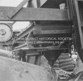
Album - Photograph, J.A. McDonald, Yarra Glen-Glenburn Road, June 1957
Jehosophat Creek – 56M295 June 1957 Weigh batcher in operationRecord of various Shire of Eltham infrastructure works undertaken during the period of 1952-1962 involving bridge and road reconstruction projects, sometimes with Eltham Shire Council Project Reference numbers quoted. It was during this period that a number of significant improvements were made to roads and new bridges constructed within the shire that remain in place as of present day (2022). In many situations, the photos provide a tangible visible record of infrastructure that existed throughout the early days of the Shire. The album was put together by or under the direction of the Shire Engineer, J.A. McDonald.infrastructure, shire of eltham, bridge construction, jehosophat creek, road construction, yarra glen-glenburn road, 1957-06 -
 Eltham District Historical Society Inc
Album - Photograph, J.A. McDonald, Yarra Glen-Glenburn Road, June 1957
Jehosophat Creek – 56M295 June 1957 Placing deck concreteRecord of various Shire of Eltham infrastructure works undertaken during the period of 1952-1962 involving bridge and road reconstruction projects, sometimes with Eltham Shire Council Project Reference numbers quoted. It was during this period that a number of significant improvements were made to roads and new bridges constructed within the shire that remain in place as of present day (2022). In many situations, the photos provide a tangible visible record of infrastructure that existed throughout the early days of the Shire. The album was put together by or under the direction of the Shire Engineer, J.A. McDonald.infrastructure, shire of eltham, bridge construction, jehosophat creek, road construction, yarra glen-glenburn road, 1957-06 -
 Eltham District Historical Society Inc
Negative - Photograph, J.A. McDonald, Healesville-Yarra Glen Road, c.May 1958
‘U’ slabs Paul Creek bridge, Tarrawarra Contractor WolfRecord of various Shire of Eltham infrastructure works undertaken during the period of 1952-1962 involving bridge and road reconstruction projects, sometimes with Eltham Shire Council Project Reference numbers quoted. It was during this period that a number of significant improvements were made to roads and new bridges constructed within the shire that remain in place as of present day (2022). In many situations, the photos provide a tangible visible record of infrastructure that existed throughout the early days of the Shire. The album was put together by or under the direction of the Shire Engineer, J.A. McDonald.infrastructure, shire of eltham, bridge construction, 1958-05, healesville-yarra glen road, paul creek bridge, w.e. wolf, tarrawarra -
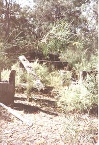 Halls Gap & Grampians Historical Society
Photograph - Coloured
An old bridge at Back Creek on the Heatherlie Quarry Rail line.Photo shows the beginning of a bridge that has become dilapidated with time. Large beams lie around covered in weeds. Bushy growth has grown over the bridge.structures, bridges