Showing 3241 items
matching council records
-
 Ringwood and District Historical Society
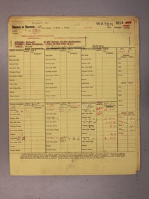
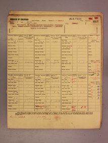
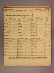
Administrative record - Rate Books, Borough of Ringwood Valuation & Rate Cards for 1944-49 (Assessments 3249-53), March 2012
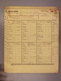
Originally stored at Ringwood Council offices, then taken to PROV.Only source of ratepayers in the Borough of RingwoodDigital imagesBedford Road, Ringwood. For Osmond Wickham, Geoffrey Anderson, Walter & Anna Gordon, John McRae & Frederick Motteram (Colman Estate). -
 Ringwood and District Historical Society
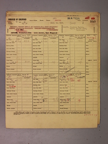
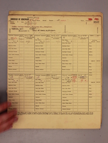
Administrative record - Rate Books, Borough of Ringwood Valuation & Rate Cards for 1944-49 (Assessments 3245-48), March 2012
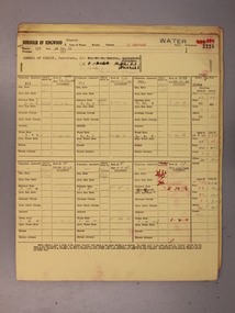
Originally stored at Ringwood Council offices, then taken to PROV.Only source of ratepayers in the Borough of RingwoodDigital imagesBedford Road, Ringwood. For Constance Stubbs, Clarence Walker, Elizabeth Shaw & Percival Eden (Colman Estate). -
 Ringwood and District Historical Society
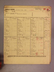
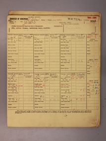
Administrative record - Rate Books, Borough of Ringwood Valuation & Rate Cards for 1944-49 (Assessments 3240-44), March 2012
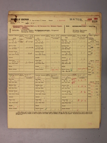
Originally stored at Ringwood Council offices, then taken to PROV.Only source of ratepayers in the Borough of RingwoodDigital imagesBedford Road, Ringwood. For Stewart Dickson, Vera Arblaster, Thomas Hartle and William Fenelon. -
 Ringwood and District Historical Society
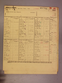
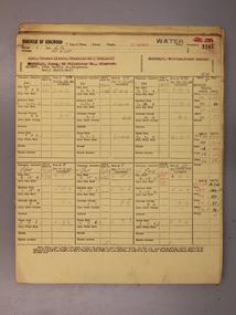
Administrative record - Rate Books, Borough of Ringwood Valuation & Rate Cards for 1944-49 (Assessments 3235-39), March 2012
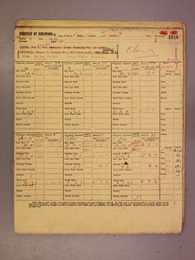
Originally stored at Ringwood Council offices, then taken to PROV.Only source of ratepayers in the Borough of RingwoodDigital imagesBedford Road, Ringwood. For Leslie Coyle, Leslie Smith, Valerie & Peter Stratton, Brendon Conlon and Theresa Nott. -
 Ringwood and District Historical Society
Administrative record - Rate Books, Borough of Ringwood Valuation & Rate Cards for 1944-49 (Assessments 3230-34), March 2012
Originally stored at Ringwood Council offices, then taken to PROV.Only source of ratepayers in the Borough of RingwoodDigital imagesBedford Road, Ringwood. For James & Agnes King, Allan & May Miller, Roy & Grace Caughey and Alexander Kofoed. -
 Ringwood and District Historical Society
Administrative record - Rate Books, Borough of Ringwood Valuation & Rate Cards for 1944-49 (Assessments 3225-29), March 2012
Originally stored at Ringwood Council offices, then taken to PROV.Only source of ratepayers in the Borough of RingwoodDigital imagesBedford Road, Ringwood. For Church of Christ, Graham Gibson, Anna Jones, Stella Smith, & William & Eva Bell. -
 Ringwood and District Historical Society
Administrative record - Rate Books, Borough of Ringwood Valuation & Rate Cards for 1944-49 (Assessments 3220-24), March 2012
Originally stored at Ringwood Council offices, then taken to PROV.Only source of ratepayers in the Borough of RingwoodDigital imagesBedford Road, Ringwood. For Richard & Georgina Pauline, Annie Cubbit, Bruce Gibson and Ringwood Borough Council. -
 Ringwood and District Historical Society
Administrative record - Rate Books, Borough of Ringwood Valuation & Rate Cards for 1944-49 (Assessments 3216-19), March 2012
Originally stored at Ringwood Council offices, then taken to PROV.Only source of ratepayers in the Borough of RingwoodDigital imagesBarkly Street, Ringwood. For William & Patricia Ryan, MP Tobin, John Burns & Keith Storey. -
 Ringwood and District Historical Society
Administrative record - Rate Books, Borough of Ringwood Valuation & Rate Cards for 1944-49 (Assessments 3212-15), March 2012
Originally stored at Ringwood Council offices, then taken to PROV.Only source of ratepayers in the Borough of RingwoodDigital imagesBarkly Street, Ringwood. For Thomas Hall, Gwen Cox, Ethel & William Ely & Muriel Bailey. -
 Ringwood and District Historical Society
Administrative record - Rate Books, Borough of Ringwood Valuation & Rate Cards for 1944-49 (Assessments 3207-11), March 2012
Originally stored at Ringwood Council offices, then taken to PROV.Only source of ratepayers in the Borough of RingwoodDigital imagesBarkly Street, Ringwood. For SJ Press (Elphin Est.), Emily Buzolich (Pratt's Est.), Alexander & Margaret McCleave, Gilbert & Myfanwy Aird & Jack McDonald. -
 Ringwood and District Historical Society
Administrative record - Rate Books, Borough of Ringwood Valuation & Rate Cards for 1944-49 (Assessments 3203-06), March 2012
Originally stored at Ringwood Council offices, then taken to PROV.Only source of ratepayers in the Borough of RingwoodDigital imagesBarkly Street, Ringwood (all Elphin Est.). For Alfred Fox, David & Kathleen Oliver, Robert & Grace Holton, GT Press & Thomas & Edith Turner. -
 Ringwood and District Historical Society
Administrative record - Rate Books, Borough of Ringwood Valuation & Rate Cards for 1944-49 (Assessments 3198-3202), March 2012
Originally stored at Ringwood Council offices, then taken to PROV.Only source of ratepayers in the Borough of RingwoodDigital imagesBarkly Street, Ringwood. For Constance & William Hall, William Hancock (Allman's Estate), Lilian Gawith, James McDonald & John & Beryl Albert. -
 Ringwood and District Historical Society
Administrative record - Rate Books, Borough of Ringwood Valuation & Rate Cards for 1944-49 (Assessments 3193-3197), March 2012
Originally stored at Ringwood Council offices, then taken to PROV.Only source of ratepayers in the Borough of RingwoodDigital imagesFor BR Stewart (Belgrave Road), Violet Sampson (Barkly Street), Margaret Cowin (Barkly Street), Edith Phillips (Barkly Street) & Arthur George (Barkly Street, Allman's Estate). -
 Bendigo Military Museum
Administrative record - Advisory Committee on Commonwealth Mapping Meeting Notes - (National Mapping Council Meetings), Circa 1972
... on Commonwealth Mapping Meeting Notes - (National Mapping Council Meetings ...Advisory Committee on Commonwealth Mapping (ACOCM) Meeting Notes. 15 Items of typed pages and diagrams. .1 Letter to the Hon WS Kent Hughes MVO, OBE, Mc, ED, MP, Minister for the Interior, ACT Signed Jos Francis. Cabinet Decision taken on 22 July 1954, effects on current military mapping agreements between AUS, UK and USA. Australian responsibility "Noted was the fact that RASvy was in preparation for War." .2 Letter by H Wells Lieutenant General, Chief of the General Staff, 17 Feb 1955. Refers to the invitation of Major General RL Brown UK Defence to visit Australia to help align the mapping programme. .3 Draft Cabinet Submission on National Mapping Survey and Mapping Co-ordination of the 22 July 1955. Attachment 1 Cabinet Minute, Vice-President's letter Canberra22 July 1954. Decision No2 (VP). Submission 8 National Mapping Survey and Mapping Co-ordination. .4 Air photography and Mapping Programme 1956/57. Signed by LF Fitzgerald OBE Director of Military Survey 26 Jan 56. .5 Letter Hon WS Kent Hughes MVO, OBE, MC, ED, MP. Minister for the Interior ACT. Confirming the Cabinet Decision No2 (VP) Signed by Joe Francis .6 National Mapping Programme 1956/57. States a view to Army's contribution to this programme .7 Clarifies Army participation in Cabinet Decision No2 (VP) .8 History of National Mapping Asst Secretary (General) 24 Apr 1958 .9 Report on Army Committee on National Mapping. 2 July 1958 .10 RASvy Brief Review of Activities Jan - Dec 1964 .11 Advisory Committee on Commonwealth Mapping Meeting Notes 12 Feb 1965 - Agenda item 8. This endorsed the principle of grouping Commonwealth Mapping Agencies in a Survey Mapping Group in Canberra which included AHQ Survey Regiment. This did not come to fruition. .12 Advisory Committee on Commonwealth Mapping Meeting Notes 12 Feb 1965 - Agenda item 8 para 5.1.3 - 11.2 .13 ACOCM Meeting Agenda 1968 .14 ACOCM Meeting Minutes 1970 .15 Letter to Mr B White CBE Secretary from LF BottAdvisory Committee on Commonwealth Mapping (ACOCM) Meeting Notes. 15 Items of typed pages and diagrams. .1 Letter 22 July 1954 .2 Letter 17 Feb 1955 .3 Letter 22 July 1955 .4 letter 26 Jan 1956 .5 Letter Hon WS Kent Hughes Minister for the Interior ACT .6 National Mapping Programme 1956/57 .7 Clarifies Army participation in Cabinet Decision No2 (VP) .8 History of National Mapping 24 Apr 1958 .9 Report on Army Committee on National Mapping 2 July 1958 .10 RASvy Brief Review of Activities Jan - Dec 1964 .11 Advisory Committee Meeting Notes 12 Feb 1965 - Agenda item 8 .12 Advisory Committee Meeting Notes 12 Feb 1965 - Agenda item 8 para 5.1.3 - 11.2 .13 ACOCM Meeting Agenda 1968 .14 ACOCM Meeting Minutes 1970 .15 Letter to Mr B White CBE Secretary from LF Bottroyal australian survey corps, rasvy, fortuna, army survey regiment, army svy regt, asr, national mapping -
 Warrnambool and District Historical Society Inc.
Administrative record - Minutes Book Sub Committees, Warrnambool City Council 1950-1973, Circa 1950
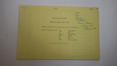
This book contains the minutes from a wide range of community groups such as Sun Youth Travel Scheme, Foreshore Reserve Committee of Management, Victorian Centenary Celebration, and Testimonials for various councillors, Freedom from Hunger Campaign, Historical Society, Miss Australia Quest, Meals on Wheels, Winston Churchill Memorial Appeal, and Warrnambool Cricket Grand Reserve. The meetings were held in the period 1950 to 1973.An interesting collection of minutes with a very diverse cross-section of community groups. It shows the workings of councillors with a range of community groups some of which such as Meals On Wheels have become an important part of community support for people. Red cover. Navy blue and white patterned inside front and back covers.188 blue lined pages with handwritten minutes for various sub committees and community groups.The letter M on base of spine. A shell series Product No 4222. warrnambool, minute book minutes book 1950- 1973, warrnambool and district historical society, sun youth travel scheme, warrnambool foreshore reserve committee of management, victorian centenary celebration, freedom from hunger campaign, miss australia quest, meals on wheels, winston churchill memorial appeal, warrnambool cricket grand reserve -
 Warrnambool and District Historical Society Inc.
Financial record - Ledger: Cash Book Warrnambool City Council, 1894-1925. Commons, Circa 1894
This ledger contains entries for expenses such as wages, street trees, ploughing and repairs, and receipts for items such as common fees, sale of bulls. There are also a number of loose sheets with lists of names and receipts. Quite a number of entries seem to relate to the running of the common areas and expenses of same. The entries in this ledger relate to a period of time in Warrnambool’s history where there was a council run common areas such as the Western Reserve and common proper.Hard green cloth cover with tan suede spine and corners Title Cash book written in gold lettering on red background on spine. Inside front and back covers is red and blue mottled paper. 183 pages.In grey lead on first page B/B T/-warrnambool, warrnambool common, western reserve -
 Warrnambool and District Historical Society Inc.
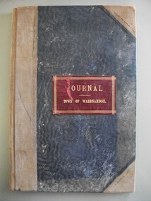
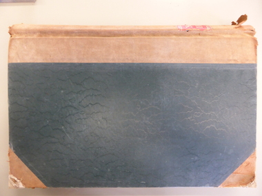
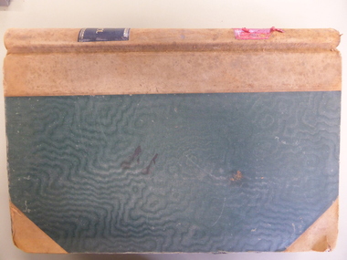
Financial record - Journal Town of Warrnambool 1914-1926, Circa 1914
This journal shows payments made for a number of Council and community expenses. It includes entries relating to Town Hall, Botanic gardens, Parks, road costs, baths, beach improvements, Warrnambool Racing Club. It shows account transfer journals Provides an overview of expenses of Council in the early 20th century.Dark blue water wave fabric over card with light brown points and binding. Red leather label with gold text and border. Pages edged in pink green, yellow and white pattern. 102 Pages.Journal Town of Warrnambooltown of warrnambool 1914-1926, warrnambool expenses 1920, warrnambool town hall, warrnambool baths -
 Warrnambool and District Historical Society Inc.
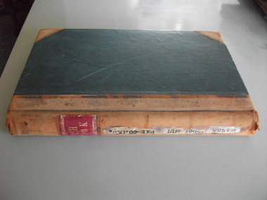
Financial record - Ledger Warrnambool City Council cash book 1940-1946, Circa 1940
... of running a city council in the 1940’s. warrnambool city expenses ...This cash book contains details of payments made and money collected from the period 1940-1946 There are expenses such as road maintenance, stationery, Abattoirs, ice, Botanic Gardens, Booval Gardens, beach improvements, sanitary services, salaries and wages.This cash book provides a detailed description of the day to day expenses of running a city council in the 1940’s. Large green cloth hard cover with tan point and spine. Inside front and back covers is patterned red and blue with thick black diagonal lines. It has binding tape inside front and rear covers. 201 pages edged in pink, green, yellow, and white. The pages have the heading in black print, “City Of Warrnambool.”Label inside front cover,” E. Whitehead & Co, Pty Ltd, Stationers, general Printers and Account Book Manufacturers, Griffin House, 21 Equitable Place, Melbourne. Ref No. 16380. warrnambool city expenses 1940, warrnambool city ledger 1940-1946, warrnambool history -
 Warrnambool and District Historical Society Inc.
Financial record - Warrnambool City Council, General Ledger, 1917-1921, Circa 1917
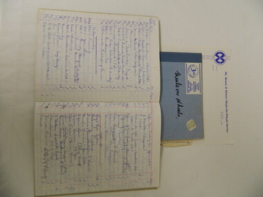
... necessary, others still remain part of council duty ...The entries in this ledger relate to the everyday expenses of the town council. It contains entries which relate to utilities, gardens, market fees, Town Hall, pure food act, interest on loans, sanitary services and fever ward. Each ledger item has a double page and the expenses incurred over the period 1917-1921.This ledger shows the involvement of council in many different aspects of administration in a town in the early part of the 20th century. While some aspects of this life in Warrnambool are no longer necessary, others still remain part of council duty and administration to the present day.Green cloth covered card cover with tan corners and spine, in leather. Inside front and back cover is patterned brown and purple. Alphabetical index at the front. 301 pages. The spine has two labels, one on black and the second on red background with gold lettering. General ledger in gold lettering on red and Town of Warrnambool in gold lettering on black. Both labels on spine.warrnambool town council 1917-1921, early warrnambool council ledger, warrnambool history -
 Warrnambool and District Historical Society Inc.
Financial record - Ledger, Warrnambool Shire Council 1899-1918, Circa 1900
... Council 1899-1918. Financial record Ledger ...Provides a collection of letters to the President and Councillors of the Shire of Warrnambool from J. M. Crawley. The period covered is 1900 to 1918. It covers such topics as repairs to bridges, purchasing of equipment, complaints, applications for roads. Names of places and structures include Dennington Bridge, Cassidy’s Bridge, Warrumyea Bridge, Yangery, Purnim. Loose within the book is a letter from a W,M(H?) Clarke of Garvoc. The letters contained in this ledger provide information on a large range of works which were carried out in the Shire in the early 1900’sDark olive green fabric cover with tan spine and cornersMinute Book in gold lettering on red background on spine.warrnambool shire council 1899-1918, crawley j w crawley, warrnambool shire offices, warrnambool -
 Kiewa Valley Historical Society
Photographs – Kiewa Cres Mt Beauty. Circa 1993. Set of 12 colour photographs
Established in 1946, during the construction of the Kiewa Hydro Electric Scheme, the township of Mt Beauty was developed by the State Electricity Commission of Victoria to provide additional accommodation for the thousands of workers during the construction of the country’s second largest hydro-electricity scheme. Although these towns were built as temporary accommodation for the workers and their families, many stayed after the scheme finished. Combined with the influx of European migrants, with their rich cultural backgrounds, all played a major part in shaping the future character of the Mount Beauty, the Kiewa Valley and Falls Creek. The Bright Council, now the Alpine Shire took over the control of the township in 1960. This relatively young town of Mount Beauty, along with the surrounding townships of Falls Creek, Bogong, Tawonga South and Tawonga, are all part of a prospering tourist area with excellent services, accommodation, food and a wide range of recreational activities available for all ages. According to Shire records, the population of Mt Beauty has grown from 1,500 in 1981 to 1,800 in 2016 with a projected increase to 2,000 in 2013The photographs taken around 1993 show a prosperous commercial centre catering for both locals and the needs of visitors. It provides a pictorial history of the changes which have occurred in the retail/commercial district of Mt Beauty over the years. It also demonstrates the attention paid by Alpine Shire towards providing accessible recreational green space around the town centre.Set of 12 colour photographs of Kiewa Cres Mt Beauty. Circa 1993 showing retail services and streetscape of the time. No markingskiewa cres mt beauty, mt beauty -
 Kiewa Valley Historical Society
Photographs – Lakeside Avenue, Mt Beauty. Circa 1993. Set of 7 colour photographs
Established in 1946, during the construction of the Kiewa Hydro Electric Scheme, the township of Mt Beauty was developed by the State Electricity Commission of Victoria to provide additional accommodation for the thousands of workers during the construction of the country’s second largest hydro-electricity scheme. Although these towns were built as temporary accommodation for the workers and their families, many stayed after the scheme finished. Combined with the influx of European migrants, with their rich cultural backgrounds, all played a major part in shaping the future character of the Mount Beauty, the Kiewa Valley and Falls Creek. The Bright Council, now the Alpine Shire took over the control of the township in 1960. This relatively young town of Mount Beauty, along with the surrounding townships of Falls Creek, Bogong, Tawonga South and Tawonga, are all part of a prospering tourist area with excellent services, accommodation, food and a wide range of recreational activities available for all ages. According to Shire records, the population of Mt Beauty has grown from 1,500 in 1981 to 1,800 in 2016 with a projected increase to 2,000 in 2013The photographs taken around 1993 show a prosperous commercial centre catering for both locals and the needs of visitors. It provides a pictorial history of the changes which have occurred in the retail/commercial district of Mt Beauty over the years. It also demonstrates the attention paid by Alpine Shire towards providing accessible recreational green space around the town centre.Set of 7 colour photographs of Lakeside Avenue, Mt Beauty. Circa 1993 showing retail services and streetscape of the time. No markingsmt beauty, lakeside ave mt beauty -
 Kiewa Valley Historical Society
Photographs – Tawonga Cres., Mt Beauty. Circa 1993. Set of 4 colour photographs
Established in 1946, during the construction of the Kiewa Hydro Electric Scheme, the township of Mt Beauty was developed by the State Electricity Commission of Victoria to provide additional accommodation for the thousands of workers during the construction of the country’s second largest hydro-electricity scheme. Although these towns were built as temporary accommodation for the workers and their families, many stayed after the scheme finished. Combined with the influx of European migrants, with their rich cultural backgrounds, all played a major part in shaping the future character of the Mount Beauty, the Kiewa Valley and Falls Creek. The Bright Council, now the Alpine Shire took over the control of the township in 1960. This relatively young town of Mount Beauty, along with the surrounding townships of Falls Creek, Bogong, Tawonga South and Tawonga, are all part of a prospering tourist area with excellent services, accommodation, food and a wide range of recreational activities available for all ages. According to Shire records, the population of Mt Beauty has grown from 1,500 in 1981 to 1,800 in 2016 with a projected increase to 2,000 in 2013The photographs taken around 1993 show a prosperous commercial centre catering for both locals and the needs of visitors. It provides a pictorial history of the changes which have occurred in the retail/commercial district of Mt Beauty over the years. It also demonstrates the attention paid by Alpine Shire towards providing accessible recreational green space around the town centre.Set of 4 colour photographs Tawonga Crescent, Mt Beauty. Circa 1993 showing retail services and streetscape of the time No markingstawonga cres mt beauty -
 Kiewa Valley Historical Society
Photographs – Holland Street North, Mt Beauty. Circa 1993. Set of 18 colour photographs
Established in 1946, during the construction of the Kiewa Hydro Electric Scheme, the township of Mt Beauty was developed by the State Electricity Commission of Victoria to provide additional accommodation for the thousands of workers during the construction of the country’s second largest hydro-electricity scheme. Although these towns were built as temporary accommodation for the workers and their families, many stayed after the scheme finished. Combined with the influx of European migrants, with their rich cultural backgrounds, all played a major part in shaping the future character of the Mount Beauty, the Kiewa Valley and Falls Creek. The Bright Council, now the Alpine Shire took over the control of the township in 1960. This relatively young town of Mount Beauty, along with the surrounding townships of Falls Creek, Bogong, Tawonga South and Tawonga, are all part of a prospering tourist area with excellent services, accommodation, food and a wide range of recreational activities available for all ages. According to Shire records, the population of Mt Beauty has grown from 1,500 in 1981 to 1,800 in 2016 with a projected increase to 2,000 in 2013The photographs taken around 1993 show a prosperous commercial centre catering for both locals and the needs of visitors. It provides a pictorial history of the changes which have occurred in the retail/commercial district of Mt Beauty over the years. It also demonstrates the attention paid by Alpine Shire towards providing accessible recreational green space around the town centre.Set of 18 colour photographs Holland Street North, Mt Beauty. Circa 1993 showing retail services and streetscape of the time. No markingsholland st mt beauty, mt beauty -
 Kiewa Valley Historical Society
Photographs – Holland Street South, Mt Beauty. Circa 1993. Set of 16 colour photographs
Established in 1946, during the construction of the Kiewa Hydro Electric Scheme, the township of Mt Beauty was developed by the State Electricity Commission of Victoria to provide additional accommodation for the thousands of workers during the construction of the country’s second largest hydro-electricity scheme. Although these towns were built as temporary accommodation for the workers and their families, many stayed after the scheme finished. Combined with the influx of European migrants, with their rich cultural backgrounds, all played a major part in shaping the future character of the Mount Beauty, the Kiewa Valley and Falls Creek. The Bright Council, now the Alpine Shire took over the control of the township in 1960. This relatively young town of Mount Beauty, along with the surrounding townships of Falls Creek, Bogong, Tawonga South and Tawonga, are all part of a prospering tourist area with excellent services, accommodation, food and a wide range of recreational activities available for all ages. According to Shire records, the population of Mt Beauty has grown from 1,500 in 1981 to 1,800 in 2016 with a projected increase to 2,000 in 2013The photographs taken around 1993 show a prosperous commercial centre catering for both locals and the needs of visitors. It provides a pictorial history of the changes which have occurred in the retail/commercial district of Mt Beauty over the years. It also demonstrates the attention paid by Alpine Shire towards providing accessible recreational green space around the town centre.Set of 16 colour photographs Holland Street South, Mt Beauty. Circa 1993 showing retail services and streetscape of the time. No markingsholland st mt beauty, mt beauty -
 Kiewa Valley Historical Society
Photographs – Kiewa Cres Mt Beauty. Circa 1993. Set of 12 colour photographs, circa 1993
Established in 1946, during the construction of the Kiewa Hydro Electric Scheme, the township of Mt Beauty was developed by the State Electricity Commission of Victoria to provide additional accommodation for the thousands of workers during the construction of the country’s second largest hydro-electricity scheme. Although these towns were built as temporary accommodation for the workers and their families, many stayed after the scheme finished. Combined with the influx of European migrants, with their rich cultural backgrounds, all played a major part in shaping the future character of the Mount Beauty, the Kiewa Valley and Falls Creek. The Bright Council, now the Alpine Shire took over the control of the township in 1960. This relatively young town of Mount Beauty, along with the surrounding townships of Falls Creek, Bogong, Tawonga South and Tawonga, are all part of a prospering tourist area with excellent services, accommodation, food and a wide range of recreational activities available for all ages. According to Shire records, the population of Mt Beauty has grown from 1,500 in 1981 to 1,800 in 2016 with a projected increase to 2,000 in 2013The photographs taken around 1993 show a prosperous commercial centre catering for both locals and the needs of visitors. It provides a pictorial history of the changes which have occurred in the retail/commercial district of Mt Beauty over the years. It also demonstrates the attention paid by Alpine Shire towards providing accessible recreational green space around the town centre.Set of 12 colour photographs Kiewa Cres Mt Beauty. Circa 1993 showing retail services and streetscape of the time. No markingskiewa crescent mt beauty; shopping centre; -
 Kiewa Valley Historical Society
Book - Kiewa Voters' Roll, Shire of Bright - Voters' Roll 1979 - Kiewa Riding, 1979
Electoral rolls list people who are registered and eligible to vote at federal, state, territory & local government elections and referenda. Prior to 1990 the rolls list voters in alphabetical order by surnames & first names within each Sub division of an electoral division of each State or Territory. The roll is useful & interesting for family historians and the study of demographics. Alex McCullough lived in the Shire of Bright and was on its Council. Electoral roles help to locate the residential address of a person in a particular year or over a period of years. They can be used as a substitute for census records for family historians and the history of a particular place in this case the Kiewa Valley - Tawonga and Tawonga South.Approx. 60 pages of firm yellow paper with black typed print on one side only in 'landscape' format. Held by three staples. Each page has column - numbered 1 to 943; Surnames in alphabetical order; Given names; Occupation; includes L (=land). Address followed by Lot number and parish. Includes Tawonga and Tawonga SouthOn the cover on the right hand side handwritten and difficult to read - "Jack? / Indi / Benambra / Nth Eastern / Division? of Dawson / 123 Victoria Rd. / Melbourne 3000"shire of bright; kiewa riding; voters roll; alex mccullough; tawonga; tawonga south -
 Kiewa Valley Historical Society
Paper Records for Mt Beauty & District Meals On Wheels, 1960s - 2003
Mt Beauty & District Meals on Wheels committee was formed on 6th Dec. 1967, possibly under the Elderly Citizens Welfare Council News (or Senior Citizens Mt Beauty) with service commencing on 16th July 1968. Volunteers transported meals from the Hospital Kitchen to the elderly and sick members of the community each day including weekends. Eventually the Shire managed the meals and roster until recent times when, in 2016, Alpine Health took over. Members of the Mt Beauty community recognised the need for meals to be delivered to the elderly and sick. They formed a committee and organised the means (rules, meals, containers, roster ) by which they could achieve their goal with volunteers and the Tawonga District Hospital. The first delivery was recorded by the press and was on film by AMV 4 Albury TV station for their local news. The official party included - local member, Tom Mitchell, Shire representatives, Alec McCullough and Dr Jean Hutching who joined the volunteers for a luncheon at the Mt Beauty Chalet.Paper records for the Mt Beauty Meals On Wheels Program includes photos, newspaper cuttings, committee documents, roster, petrol book, minute books 1983 - 1998, correspondence book, stationary and a brief history of the first delivery in 1968.meals on wheels; mt beauty; tawonga district hospital; -
 Warrnambool and District Historical Society Inc.
Document, Map: Lady Bay 1853, 1853
This is one of the earliest surveys and maps of Warrnambool harbor, Lady Bay. Being done in 1853, it shows the depths of the bay area marked in fathoms, currents and directions and areas of rocks around mouth of the Merri and the Western side of the bay as well as a large sand spit to the middle right of the beach region.. It also marks the large areas of seaweed and fuci in the outer bay area. It has the area of Pertobe Lagoon marked and shows the early tracks to the town. The engraving work was done by Tulloch and Brown, with Tulloch being one of the earliest engravers and lithographers in the state of Victoria. He arrived in Melbourne in 1849 and set up business with James Davie Brown in 1853 with Brown being a map engraver. They were awarded bronze and silver medals for their work at the Victorian Industrial Exhibition. He also worked in the vignettes on the Proeschel Map of Victoria.This map is of high historical and comparitive significance as it shows the Lady Bay area prior to the changes that have occurred in the last 160 years with the building of the breakwater. The issue regarding access to Lady Bay remains a current one. The engraver D Tulloch engraved some of the earliest scenes of the goldfields in Ballarat and as such has left a record of a very early and important era in Australian history. Rectangular cream paper with black text. Map area is outlined by fine black lined border. Key in top right hand corner and scale at bottom middle of map.Map is labelled Town of Warrnambool printed at top of map. Small logo at top right corner which has “Hydrographic Department” in circle around an anchor. Lady Bay Warrnambool Surveyed by John Barrow assistant surveyor Engraved by Tulloch & Brown in bottom right corner. Melbourne engraved by order of the legislative Council of Victoria in middle bottom.map, warrnambool, town of warrnambool map 1853, tulloch & brown map 1853, lady bay warrnambool,, warrnambool harbour, warrnambool breakwater, warrnambool beach -
 Warrnambool and District Historical Society Inc.
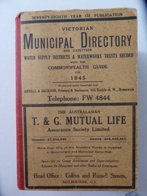
Stamp, W'bool Co.op Commons Seal, 1945
This is a Victorian Municipal Directory for 1945, containing general information on all municipalities in Victoria, a Gazeteer, a Commonwealth Guide and a Water Supply Record. Municipal Directories were published annually in Victoria from 1867 on. This directory came from the Shire of Mortlake which was established in 1864 when it had an area of 2137 square kilometres. The Shire of Mortlake was abolished in 1994 and merged with other neighbouring shires to form the present day Shire of Moyne. This book is very useful to researchers as it contains much information on the City, Borough and Shire structures, the Council employees and Government employees of all the municipalities. It has, therefore, important local information on Warrnambool and the surrounding areas in 1945. This is a soft cover book of 1114 pages. It has a buff- coloured cover with red binding on the spine. The printed material on the covers is printed in black. It has a blue stamp of the Shire of Mortlake on several pages. The book contains several advertisements for Melbourne businesses. ‘Shire of Mortlake’ shire of mortlake, local government in victoria, warrnambool history