Showing 423 items matching " map of system"
-
 Ballarat Tramway Museum
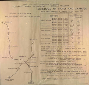
Poster - "Schedule of Fares and Charges - Bendigo", State Electricity Commission of Victoria (SECV), Aug. 1966
Drawing showing Bendigo Tramways (SEC) Fares, Charges, and Section Map. Also gives charges for Scholar's Monthly tickets, Luggage, Parcels, Newspapers and Chartered trams. Dated August 1966 Fares only in decimal currency. Titled - "Schedule of Fares and Charges (as from) - 1 September 1966". Shows offices as Dispensary Walk. Two copies held.Demonstrates the way the SEC advised passengers in Ballarat and Bendigo how the fare and charges systems worked and yielded information about the fare charges in force at the time. A copy was provided in each tram behind framed glass.Dye line print of a drawing on paper."BTPS" in blue ink on reartrams, tramways, bendigo, fares, sections, map -
 Ballarat Tramway Museum
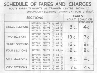
Poster, State Electricity Commission of Victoria (SECV), "Schedule of Fares and Charges - 26/1/1969", Jan. 1969
Demonstrates the way the SEC advised passengers in Ballarat and Bendigo how the fare and charges systems worked and yielded information about the fare charges in force at the time. A copy was provided in each tram behind framed glass.Dye line print of a drawing showing Bendigo Tramways (SEC) Fares, Charges, and Section Map. Drawing No. VX1/130/1 Also gives charges for Scholar's Monthly tickets, Luggage, Parcels, Newspapers and Chartered trams. Dated January 1969. Titled - "Schedule of Fares and Charges - 26 January 1969". Shows offices as Dispensary Walk. For map - see bgofsmap.jpg and for actual fare tables, btm1734i1.jpg and btm1734i2.jpg."BTPS" in blue ink on reartrams, tramways, bendigo, fares, sections, map -
 Falls Creek Historical Society
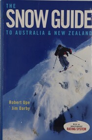
Book - The Snow Guide to Australia and New Zealand, Robert Upe & Jim Darby, 2005
The must-have guide to the snowfields of Australia and New Zealand including information about 42 resorts and 26 towns. It contains 52 detailed maps as well as tips on weather, equipment, mountain wear, mountain driving, snow safety and fitness, plus tips for first timers. Snow fields are assessed on a ratings system covering slope difficulty (beginner, intermediate and advanced), road access, kid appeal, basic facilities, food and shelter.A publication of 315 pages including an index, colour illustrations and maps.The must-have guide to the snowfields of Australia and New Zealand including information about 42 resorts and 26 towns. It contains 52 detailed maps as well as tips on weather, equipment, mountain wear, mountain driving, snow safety and fitness, plus tips for first timers. Snow fields are assessed on a ratings system covering slope difficulty (beginner, intermediate and advanced), road access, kid appeal, basic facilities, food and shelter.australian snowfields, new zealand snowfields -
 Ballarat Tramway Museum
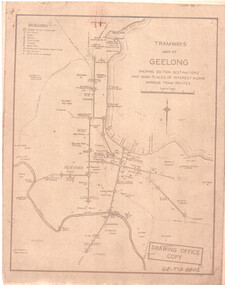
Drawing, State Electricity Commission of Victoria (SECV), "Tramways Map of Geelong", 1930s
SEC Drawing GE-T13-8802, "Tramways Map of Geelong" shewing section destinations and main places of interest along various tram routes. Undated, prior to the construction of the Beach route in 1940. See item 3469 for a larger drawing. Scanned in both colour and greyscale.Yields information about the Geelong system prior to the construction of the Beach route in 1940.Map or drawing photocopied onto heat sensitive paper - quarto size.tramways, geelong, maps, map, track layout -
 Victorian Railway History Library
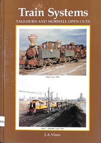
Book, Vines, J.A, Train Systems Yallourn and Morwell Open Cuts, 1994
... in Gippsland Victoria. ill, maps, p.248. Train Systems Yallourn ...A history of the narrow gauge colliery between the Yallourn and Morwell open cut brown coal mines in Gippsland Victoria.ill, maps, p.248.non-fictionA history of the narrow gauge colliery between the Yallourn and Morwell open cut brown coal mines in Gippsland Victoria.colliery railroads - victoria - history, narrow gauge railroads - australia - history -
 Bendigo Military Museum
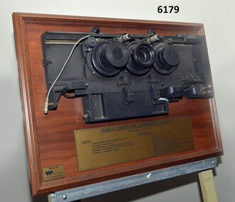
Plaque - Mounted Klimsch Commodore Cartographic Camera Lenses, WYCOMBE Constructions Pty Ltd, 1997
... to less wastage in time and materials. Its variomat lens system... to less wastage in time and materials. Its variomat lens system ...These are the Lenses from the Klimsch Commodore Cartographic Camera that was located in Lithographic Squadron at the Army Survey Regiment, Fortuna, Bendigo. The KLIMSCH Commodore camera was originally introduced to the Survey Regiment in 1953 and was the largest in the Southern Hemisphere. It was replaced with a new model of the same size in 1977. These lenses are from this new model. The new model with its computer-based interface provided productivity gains with improved speed and its consistent results led to less wastage in time and materials. Its variomat lens system provided improved retention of map feature linear weights during the camera reduction process. The camera which was specially made for the Australian Army in Germany was fully automatic and power operated. It was claimed to be one of the biggest automatic cameras of its type in the world. It was made to the specifications of the Royal Australian Army Survey Corps to assist in the production of the very high standard maps for the Australian Army. THIS KLIMSCH COMMODORE CARTOGRAPHIC CAMERA was in operation 1977 - 1997". It was a Precision Darkroom Camera especially suited for Cartographic Reproduction of Line, Continous Tone, Halftone and Colour Separation. Reproduction of Negatives and Positives from a variety of Reflection or Transmission Originals. Its characteristics were: Maximum Negative Size 1.27m sq, Copy Holder (Vacuum) 2m sq, Maximum Enlargement 400%, Maximum Reduction 13%, Automatic 60, 90 and 120cm Focal Length Lens, Transmission or Reflection Originals, Pulsed Xenon, Photo Flood or Fluorescent Tube Light Source, Maximum Reflection Original 1.3m x 1.85m, Maximum Transmission Original 1.3m x 1.85m, Exposure Light Monitoring System." The camera was superseded by computerized image manipulation software associated with the Automap system. These significant and extremely high-quality Lenses were retrieved by WYCOMBE Constructions Pty Ltd during the demolishment of the camera in 1997 and then mounted on a display board. See also Item 6189.4P for more photographs of the camera.Lenses from the Klimsch Commodore Cartographic Camera mounted on a very heavy timber display board. The display board contains an engraved plate that describes the technical characteristics of the camera."KLIMSCH COMMODORE CARTOGRAPHIC CAMERA 1977 - 1997", "FUNCTION: Precision Darkroom Camera especially suited for Cartographic Reproduction of Line, Continous Tone, Halftone and Colour Separation. Reproduction of Negatives and Positives from a variety of Reflection or Transmission Originals." "CHARACTERISTICS: Maximum Neg Size 1.27m sq, Copy Holder 2m sq, Maximum Enlargement 400%, Maximum Reduction 13%, Automatic 60, 90, 120cm Focal Length Lens, Transmission or Reflection Originals, Pulsed Xenon, Photo Flood or Fluorescent Tube Light Source, Maximum Reflection Original 1.3m x 1.85m, Maximum Transmission Original 1.3m x 1.85m, Exposure Light Monitoring System." royal australian survey corps, rasvy, fortuna, army survey regiment, army svy regt, asr, litho -
 Bendigo Military Museum
Poster - Map Production flow chart poster using Automap 2, Army Survey Regiment, Bendigo, 1982
This poster designed to be folded into a brochure describes the second phase of the computer assisted cartographic system to be used by the Royal Australian Survey Corps in the establishment of a topographic data base, Future tactical applications and map products using the data base are displayed. A topographic map of Series R631 1:100,000 Helenvale, Queensland printed on the reverse side that was produced by the Automap system using information from the topographic data base. This is the fifth edition of the poster.A multi colour poster of map production using the Automap 2 system. Poster shows a schematic and pictorial flow chart diagram of the stages of the map production process using the Automap 2 system. The poster was intended to be folded into a small brochure. A 1:100,000 Army Survey Map Series R631, 7966 Helenvale, Queensland Edition 2 is printed on the reverse side of the poster. The map is an example of one of the initial maps produced on the Automap 2 System at the Army Survey Regiment, Bendigo.royal australian survey corps, rasvy, fortuna, army survey regiment, army svy regt, asr, automap 2 -
 Bendigo Military Museum
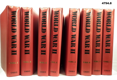
Magazine - BINDERS, CONTAINING MAGAZINE COLLECTION, ORBAS Publishing Ltd, World War ll, Unknown
Eight binders containing a magazine collection. Binder - cardboard with red coloured plastic over cardboard - metal fastening system. Black and gold print on spine. Magazines - 3360 pages in total, plain white paper, illustrated black and white and colour photos and maps. Vol 1 - pages 1 to 420. Vol 2 - pages 421 to 840. Vol 3 - pages 841 to 1260. Vol 4 - pages 1261 to 1680. Vol 5 - pages 1681 to 2100. Vol 6 - pages 2101 to 2520. Vol 7 - pages 2521 to 2940. Vol 8 - pages 2941 to 3360. Index to all binders at back Vol 8.magazines, ww11, military -
 Bendigo Military Museum
Photograph - AUTOMAP 1 Production – Army Survey Regiment, Fortuna, Bendigo, c1978-1980
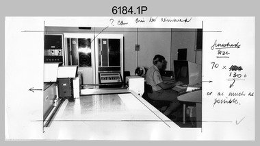
This collection of 20 photos was most likely taken in c1978. The AUTOMAP 1 computer assisted cartography and mapping system was introduced in 1975. The components of AUTOMAP 1 were the Input Sub-System of four Wild B8s stereoplotters and three Gradicon digitising tables, the Optical Line Following Sub-System – Gerber OLF, the Verification Sub-System – Gerber 1442 drum plotter, the General Purpose Sub-system – HP21MX computer and the Output Sub-System – Gerber 1232 flatbed plotter). The first map was published in 1978 (Strickland 3665-3, 1:50,000). AUTOMAP 1 was the first computer assisted cartography and mapping system utilised by the Survey Corps and was the first system used by Australian mapping organisations. The history of the AUTOMAP 1 system is covered in more detail with additional historic photographs, in pages 116-118 of Valerie Lovejoy’s book 'Mapmakers of Fortuna – A history of the Army Survey Regiment’ ISBN: 0-646-42120-4. See items 6122.20P, 6410.24P, 6183.19P, 6200.5P, and 6222.17P for additional photographs of the AUTOMAP 1 system.This is a set of 20 photographs of Air Survey Squadron military and civilian personnel operating AUTOMAP 1 equipment at the Army Survey Regiment at Fortuna, Bendigo, c1978-1980. Black and white photos .1P to .18P are on photographic paper and were scanned at 300 dpi. Photo .4P is in colour and mounted with a duplicate on manilla card. Black and white photos .19P to .20P are on 35mm negative film and scanned at 96 dpi.They are part of the Army Survey Regiment’s Collection. .1) - Photo, black & white, c1978-1980, Gerber Optical Line Follower (OLF), SSGT John Bennett. .2) - Photo, black & white, c1978-1980, HP21MX computer General Purpose Sub-system. .3) - Photo, black & white, c1978-1980, Gerber OLF .4) - Photo, colour, c1978-1980, unidentified digitising on Gradicon edit table. .5) - Photo, black & white, c1978-1980, Gerber verification drum plotter. .6) - Photo, black & white, c1978-1980, Gerber OLF, CAPT Rob Bridge. .7) - Photo, black & white, c1978-1980, Programming and system administration, SGT Alan Toogood. .8) - Photo, black & white, c1978-1980, Unidentified digitising on Gradicon edit table. .9) - Photo, black & white, c1978-1980, CPL Rick Downie digitising on Gradicon edit table. .10) - Photo, black & white, c1978-1980, SPR Dave Irving digitising on Gradicon edit table. .11) - Photo, black & white, c1978-1980, Gerber OLF and CPL Rick Downie. .12) - Photo, black & white, c1978-1980, 1130 Computer System administration, L to R: unidentified, SSGT Les Dixon, SPR Geoff Havelberg. .13) - Photo, black & white, c1978-1980, AUTOMAP 1 tape administration, Maryanne De Groot. .14) - Photo, black & white, c1978-1980, AUTOMAP 1 tape drive. .15) - Photo, black & white, c1978-1980, HP21MX computer General Purpose Sub-system. .16) - Photo, black & white, c1978-1980, digitising topographic features with a Wild B8 stereo plotter, L to R: unidentified, CPL John Smith. .17) - Photo, black & white, c1978-1980, digitising topographic features with a Wild B8 stereo plotter, CPL John Smith. .18) - Photo, black & white, c1978-1980, digitising topographic features with a Wild B8 stereo plotter, CPL Adrian Rynberk. .19) - Photo, black & white, c1978-1980, Programming and system administration, SGT Alan Toogood. .20) - Photo, black & white, c1978-1980, Gerber OLF, CPL Chris Edwards. .1P to .20P - No personnel are identified.royal australian survey corps, rasvy, army survey regiment, army svy regt, fortuna, asr, automap 1 -
 Ballarat Tramway Museum
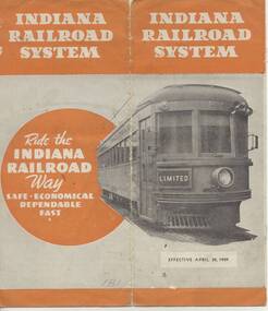
Ephemera - Timetable, Indiana Railroad, "Indiana Railroad system, Timetable, April 30, 1939" - Wal Jack Collection, Apr. 1932
Eight page (folded) timetable for the Indiana Railroad (Interurban Traction Co.) in receivership at time (see page 2), map of page 1, showing routes and connecting lines, bus services, services, days run etc. Record images added 20/8/2013.On each timetable in pencil, whether traction operated or bus (coach), where coach, crossed out in pencil.indiana railroad (electric cars), indianapolis, terre haute, timetables -
 Ballarat Tramway Museum
Memorabilia - Event Materials, The Courier Ballarat, "Ballarat Begonia Festival - Official Program Guide", 31/03/2000 12:00:00 AM
Forty page full colour printed program for the 2000 Begonia Festival. Includes festival events, maps, details of related events. On page 38 is an half page item on the Ballarat Tramway Museum. First photo features Stephen Butler in the cab of tramcar, with another tramcar (40) in the background - taken at depot junction, some details on the Ballarat Tramway system and details of the BTM itself. A second photograph features four trams at the Loop (40, 671, 13 and 26) during Boxing Day 1999. Details of the program production on page 3. Images items include reproductions of each photograph and the general layout of the item itself. See 1347i4 for image of the front cover. See also Reg Item 5466.1 to 5466.3 for other year 2000 brochures.trams, tramways, btm, begonia festival, festival program -
 Ballarat Tramway Museum
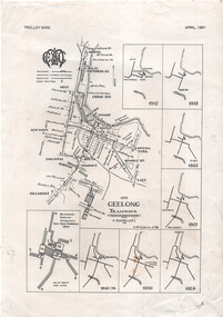
Map - "Geelong tramways", Ken McCarthy, 1981
Map titled "Geelong tramways" prepared by Ken McCarthy Feb. 1981 showing the Geelong tram system with major street names, with a service frequency chart for weekdays in 1951 and 7 small maps showing the various stages of system development from 1912 to 1940. Has an insert for the depot layout. Produced for Ken's article on Geelong Tramways in the April 1981 issue of Trolley Wire, published by the Sydney Tram Museum.Yields information about the Geelong tram system and has a close association with Ken McCarthy.A4 printed sheet - from the April 1981 issue of Trolley Wire magazine.tramways, geelong, map, trolley wire -
 Bendigo Military Museum
Photograph - 4th Field Survey Squadron – Operation MIZMAZE 92, Kimberley region, Western Australia, 1992
This is a set of 40 photographs taken in 1992 during 4th Field Survey Squadron’s deployment on Operation MIZMAZE 92 in the Kimberley region of Western Australia from the 13th of May to the 14th of July 1992. The area of operations was Wyndham, Halls Creek and Sandfire Flat. It was a two-part operation involving the field completion of topographic maps and the acquisition of mapping control by GPS field parties utilising Texas Instruments TI4100 Global Positioning System receivers. Survey parties conducted field checking of topographic maps and GPS control acquisition in Perentie 110 Series Survey variant FFR Land Rovers. Three Bell Kiowa LOH helicopters provided by 162 Recce Sqn supported field checking and limited deployment of GPS surveys parties. C-l30 Hercules from 36 Sqn supported deployment and extraction of personnel and equipment to and from from the AO. A Cessna 404 Titan Ambassador from Vee-H Aviation was used as the Wild RC10 camera platform for aerial photography acquisition.This is a set of 40 photographs taken in 1992 during 4th Field Survey Squadron’s deployment on Operation MIZMAZE 92 in the Kimberley region of Western Australia. The colour photographs are on 35mm negative film and are part of the Army Survey Regiment’s Collection. The photographs were scanned at 96 dpi. .1) - Photo, colour, 1992. CAPT Craig Hersant. .2) - Photo, colour, 1992. Unidentified officer/soldier. .3) & .4) - Photo, colour, 1992. Aboriginal rock art - Wandjina Gunduran, Donkey Creek. .5) - Photo, colour, 1992. Aboriginal rock art - Track Wandjinas, Donkey Creek. .6) & .7) - Photo, colour, 1992. CAPT Craig Hersant. .8) - Photo, colour, 1992. Kimberley region topography. CPL Glen Weatherell. .9) - Photo, colour, 1992. Unidentified personnel .10) - Photo, colour, 1992. Supermarket at unknown location. .11) to .13) - Photo, colour, 1992. Caravan park at unknown location. .14) - Photo, colour, 1992. Old bridge at Fitzroy Crosssing. .15) & .16) - Photo, colour, 1992. Survey party in Perentie 110 Series Land Rover. .17) & .18) - Photo, colour, 1992. Kimberley region topography. .19) - Photo, colour, 1992. Kimberley region topography. CPL Glen Weatherell. .20) - Photo, colour, 1992. Kimberley region topography, possibly the Bungle Bungles. .21) - Photo, colour, 1992. Kimberley region topography. SGT Frank Downie. .22) - Photo, colour, 1992. Kimberley region topography: the Bungle Bungles. .23) - Photo, colour, 1992. Kimberley region topography: the Bungle Bungles. .24) - Photo, colour, 1992. Kimberley region topography: the Bungle Bungles. SPR Neil Pedler. .25) & .26) - Photo, colour, 1992. Kimberley region topography: the Bungle Bungles. .27) - Photo, colour, 1992. Kimberley region topography. .28) - Photo, colour, 1992. Survey party with Perentie 110 Series Land Rover. .29) - Photo, colour, 1992. Kimberley region topography. .30) - Photo, colour, 1992. Survey party outside Perentie 110 Series Land Rover. .31) & .32) - Photo, colour, 1992. Survey party operating TI4100 GPS Receiver next to Perentie 110 Series Land Rover. SGT Eddie Jacobs. .33) & .34) - Photo, colour, 1992. Survey party operating TI4100 GPS Receiver next to Perentie 110 Series Land Rover. Unidentified surveyor. .35) - Photo, colour, 1992. Kimberley region topography. Hand water pump at well. .36) - Photo, colour, 1992. Survey party in Perentie 110 Series Land Rover. .37) - Photo, colour, 1992. Kimberley region topography. CPL Glen Weatherell. .38) - Photo, colour, 1992. Kimberley region topography viewed from Bell Kiowa LOH helicopter. .39) & .40) - Photo, colour, 1992. Unidentified surveyor field checking a preliminary map in a Bell Kiowa LOH helicopter..1P to .40P – There are no personnel identified. ‘1992 OP MIZMAZE annotated on negative sleeve.royal australian survey corps, rasvy, 4 fd svy sqn, op mizmaze 92 -
 Bendigo Military Museum
Photograph - Detachment - Army Survey Regiment, Bonegilla, Victoria, c1973
This is a set of six photographs of personnel from the Detachment - Army Survey Regiment taken in front of its main map production building at Bonegilla, Victoria in c1973. This cartographic map production sub-unit of the Army Survey Regiment operated in buildings owned by the School of Military Survey from 17th of June 1970 to the 30th of September 1985. A total of 800 topographic maps ranging in scale from 1:25,000 to 1: 250,000 scale were completed. A major focus of production in the 1970s was the cartographic completion of the Papua-New Guinea 1:100,000 map series and the Flexiflow quality control system was developed as a tool to coordinate production. The Flexiflow system comprised a series of job plans and charts linked to a task allocation to resource magnetic planning board. Using critical path analysis and task prioritisation, complex job planning was efficiently scheduled, and re-prioritisations readily made. Reproduction requirements were effectively coordinated by way of weekly courier to the Army Survey Regiment at Bendigo. Supervisors and technicians fully embraced the system as they could understand their role, others around them and the positive production achievements. WO1 Bill Boyd (who does not appear in this photograph) was the technical warrant officer for 11 years at the Detachment was awarded the OAM, the Order of Australia Medal for leading the development and the implementation of the Flexiflow system. By mid-1982, production of maps at these scales was undertaken digitally on Bendigo’s AUTOMAP 2 system and the Detachment reverted to production of small-scale large format RAAF aeronautical charts. Detachment personnel managed to produce 18 charts in the following two years, which was an impressive achievement for the staff, given major differences in format, specification and scales. Development of digital production of aeronautical charts in 1984-85 led to gradual reduction in production output and contracting out production was instigated to meet the shortfall and as a consequence the Detachment closed in September 1985. See pages 177 to 180 of Valerie Lovejoy’s book 'Mapmakers of Fortuna – A history of the Army Survey Regiment’ ISBN: 0-646-42120-4. for more information on the history of the Detachment at Bonegilla.This is a set of six photographs of the Detachment - Army Survey Regiment taken in front of the main map production building at Bonegilla, Victoria in c1973. The photographs were printed on photographic paper and are part of the Army Survey Regiment’s Collection. The photographic print and proofs were scanned at 600 dpi. .1) to .3) - Photo, black & white c1973. Back Row L to R: Peter Simpson, Chris Edwards, unidentified (x2), Colin Harden, Rowan Gillies, Bob Rowley OAM, Steve Hansen, Stu Thaxter. Centre Row L to R: Kevin Boehm, Dennis McCarthy, Peter Cross, unidentified, Brian Ryan, unidentified, Ian Marner, unidentified, Phil Smalley. Front Row L to R: Geoff Haynes, Bruce Wetzig, Dave Thompson, unidentified, OC Bob Roche, Ike Lever, John McCulloch, Dick Barwald, unidentified. .4) - Photo, black & white c1973. Back Row L to R: Peter Simpson, Chris Edwards, unidentified (x2), Colin Harden, Rowan Gillies, Bob Rowley OAM, Steve Hansen, Stu Thaxter. Centre Row L to R: Kevin Boehm, Dennis McCarthy, Peter Cross, unidentified, Brian Ryan, unidentified, Ian Marner, Phil Smalley, unidentified, Dick Barwald. Front Row L to R: Geoff Haynes, Bruce Wetzig, Dave Thompson, unidentified, OC Bob Roche, Ike Lever, John McCulloch, unidentified (x2). .5) - Photo, black & white c1973. Back Row L to R: Geoff Haynes, unidentified, John McCulloch, Bruce Wetzig. Front Row L to R: Dave Thompson, Ike Lever, unidentified. .6) - Photo, black & white c1973. L to R: OC Bob Roche, unidentified.There are no personnel annotated.royal australian survey corps, rasvy, army survey regiment, detachment - army survey regiment, army svy regt, asr -
 Ballarat Tramway Museum
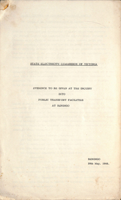
Document, State Electricity Commission of Victoria (SECV), "Evidence to be given at the inquiry into Public Transport Facilities at Ballarat", 4/1968
Details the history of the Ballarat system, take over by the SEC and the conditions of that take over by the SEC, reconstruction, financial losses incurred by the SEC, decline in passengers, its suitability, condition of the infrastructure and rolling stock. Its unsuitability to extend, effectiveness of the Geelong conversion, ability of private bus operators, tramway employees, methods of abandonment, tram tracks, overhead and impact on the electricity supply system. Dated 2/4/1968. Has a table showing the income and losses and population from 1935 to 1967, a coloured graphical presentation of tramway statistics, sheet of Fares and Charges for Ballarat. Attached to the rear of the document was an advertisement for Ballarat Tramways fare sections (See Reg Item 8039) and a map showing tram and bus services - drawing No. VX4/1/1. Attached to the second copy is drawing VD6/144, showing Geelong bus routes and former tram routes. See item 8038 for the Bendigo document dated May 1968. Yield information and demonstrates the SEC's attitude to trams in Ballarat and their finances. Report, 13 foolscap pages + three attachments stapled on left hand side, titled "Evidence to be given at the inquiry into Public Transport Facilities at Ballarat" Two copies held.secv, ballarat, trams, tramways, sec, reports, closure, history, buses, submissions -
 Ballarat Tramway Museum
Document - Report, State Electricity Commission of Victoria (SECV), "Evidence to be given at the inquiry into Public Transport Facilities at Bendigo", May. 1968
Details the history of the Bendigo system, take over by the SEC and the conditions of that take over by the SEC, reconstruction, financial losses incurred by the SEC, decline in passengers, its suitability, condition of the infrastructure and rolling stock. Its unsuitability to extend, effectiveness of the Geelong conversion, ability of private bus operators, tramway employees, methods of abandonment, tram tracks, overhead and impact on the electricity supply system. Has a table showing the income and losses and population from 1935 to 1967, a coloured graphical presentation of tramway statistics, sheet of Fares and Charges for Ballarat. Attached to the rear of the document was an advertisement for Ballarat Tramways fare sections (See Reg Item 8039) See item 9835 for the Ballarat report dated April 1968. At the rear of the second copy is drawing VX4/2/1 showing bus and tram routes in Bendigo and VD6/144A for Geelong. See Reg Item 8046 for a separate map which may have been part of this report.Yield information and demonstrates the SEC's attitude to trams in Bendigo and their finances.Report 15 Foolscap sheets, duplicated and three attachments, was stapled in the top left hand corner, titled "Evidence to be given at the inquiry into Public Transport Facilities at Bendigo" Presented 28/5/1968. Two copies held.trams, tramways, reports, closure, bendigo, history, buses, submissions -
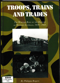 Victorian Railway History Library
Book, Rogers, Phillipa, Troops, Trains and Trades: the wartime role of the railways of Western Australia, 1939-1945, 1999
The story of the railway personnel and success of the railway system in WA in ensuring the effective movement of troops and supplies during World War 2.Index, ill, maps, p.160.non-fictionThe story of the railway personnel and success of the railway system in WA in ensuring the effective movement of troops and supplies during World War 2.world war, 1939-1945 -- transportation -- australia -- western australia, railroads -- australia -- western australia -- history -
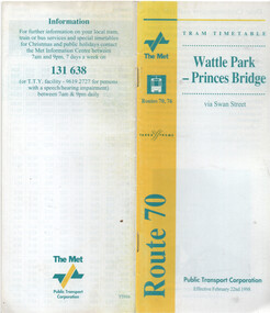 Melbourne Tram Museum
Ephemera - Timetable - route 70 - Wattle Park - Princes Bridge, The Met, 2/1998
Timetable - route 70 - Wattle Park - Princes Bridge, dated 22/2/1998, published by The Met, with Yarra Trams logo as well, and PTC name on the rear cover. Has a map of the route, forward by Geoff Lockwood Operations Supt of Camberwell depot, the Met Fare system, an advert for tram hire, timing points, and contact information.Demonstrates a timetable at the time of the formation of Yarra Trams when it was operated by The Met and the PTC.Timetable - printed, centre stapled, 24 pages.tramways, timetables, route 70, wattle park, the met, yarra trams -
 Kew Historical Society Inc
Map, Department of Lands & Survey, Map of Melbourne & Suburbs, 1899
The Melbourne & Metropolitan Board of Works was established in 1891 to oversee the introduction of a sewerage and water reticulation system in Melbourne and its suburbs. This complementary map was produced by the Department of Crown Lands & Survey [Victoria] in the same decade showing the distribution of water in Melbourne for use by fire brigades. While by 1910, there were 123,227 connections to Melbourne's water supply system, it is unclear in this 1899 map whether water was supplied to all built structures in the defined areas or only to fire hydrants and stand pipes, as we know that the first connection of a building to the sewerage system in Kew only occurred in 1904.Map accompanying report on fire protection of Melbourne showing those areas supplied with water in colour.water reticulation -- melbourne (vic.), department of lands & survey -- historic maps, fire brigades -- melbourne (vic.), cartography -
 Bendigo Historical Society Inc.
Map - Map of Lake Eppalock shoreline when empty
... system. Map Map of Lake Eppalock shoreline when empty. ...John Perry Collection. Laminated copy of map detailing Lake Eppalock shoreline when empty. Circa 1951. Has colored highlighter lines following roads leading to lake shoreline and various inundated old roads and tracks on lakebed. The dam was built by the State Rivers and Water Supply Commission of Victoria. The dam wall height is 45 metres (148 ft) and the main embankment is 1,041 metres (3,415 ft) long. At 100% capacity the dam wall was designed to hold back 304,651 megalitres (6.7014×10¹⁰ imp gal; 8.0480×10¹⁰ US gal) of water. The surface area of Lake Eppalock is 3,011 hectares (7,440 acres) and the catchment area is 2,124 square kilometres (820 sq mi). The controlled spillway is capable of discharging 8,040 cubic metres per second (284,000 cu ft/s). Lake Eppalock supplies both stock and domestic water to the Campaspe irrigation district. It also serves as a water supply to Bendigo and Heathcote and, in more recent times, Ballarat. The lake is a major attraction for those engaging in watersports, with a number of tourist parks and accommodation facilities available. Permissible activities on the lake include high-speed boating, water skiing, sailing, canoeing, fishing and swimming. The lake's water levels were low for approximately eight years between 2002 and 2010 during a prolonged drought, which restricted the amount of recreational activity until rainfall in the latter half of 2010 returned the lake to 100 percent capacity. Built between 1961 and 1964, Lake Eppalock remains the only water storage on the Campaspe River system.map, eppalock, reservoir, lake, water -
 Bendigo Historical Society Inc.
Map - Laminated map of Lake Eppalock at full capacity
... water storage on the Campaspe River system. Map Laminated map ...John Perry Collection. Laminated copy of map of Lake Eppalock at full capacity. Had highlighter markings of old roads which appear to be still in use. The dam was built by the State Rivers and Water Supply Commission of Victoria. The dam wall height is 45 metres (148 ft) and the main embankment is 1,041 metres (3,415 ft) long. At 100% capacity the dam wall was designed to hold back 304,651 megalitres (6.7014×10¹⁰ imp gal; 8.0480×10¹⁰ US gal) of water. The surface area of Lake Eppalock is 3,011 hectares (7,440 acres) and the catchment area is 2,124 square kilometres (820 sq mi). The controlled spillway is capable of discharging 8,040 cubic metres per second (284,000 cu ft/s). Lake Eppalock supplies both stock and domestic water to the Campaspe irrigation district. It also serves as a water supply to Bendigo and Heathcote and, in more recent times, Ballarat. The lake is a major attraction for those engaging in watersports, with a number of tourist parks and accommodation facilities available. Permissible activities on the lake include high-speed boating, water skiing, sailing, canoeing, fishing and swimming. The lake's water levels were low for approximately eight years between 2002 and 2010 during a prolonged drought, which restricted the amount of recreational activity until rainfall in the latter half of 2010 returned the lake to 100 percent capacity. Built between 1961 and 1964, Lake Eppalock remains the only water storage on the Campaspe River system.map, water, dam, reservoir, eppalock -
 Bendigo Historical Society Inc.
Map - Laminated worksheet - identification of inundated artifacts at Lake Eppalock
... on the Campaspe River system. Map Laminated worksheet - identification ...John Perry Collection. Laminated copy of worksheet identifying inundated artifacts at Lake Eppalock when at 10% capacity. The dam was built by the State Rivers and Water Supply Commission of Victoria. The dam wall height is 45 metres (148 ft) and the main embankment is 1,041 metres (3,415 ft) long. At 100% capacity the dam wall was designed to hold back 304,651 megalitres (6.7014×10¹⁰ imp gal; 8.0480×10¹⁰ US gal) of water. The surface area of Lake Eppalock is 3,011 hectares (7,440 acres) and the catchment area is 2,124 square kilometres (820 sq mi). The controlled spillway is capable of discharging 8,040 cubic metres per second (284,000 cu ft/s). Lake Eppalock supplies both stock and domestic water to the Campaspe irrigation district. It also serves as a water supply to Bendigo and Heathcote and, in more recent times, Ballarat. The lake is a major attraction for those engaging in watersports, with a number of tourist parks and accommodation facilities available. Permissible activities on the lake include high-speed boating, water skiing, sailing, canoeing, fishing and swimming. The lake's water levels were low for approximately eight years between 2002 and 2010 during a prolonged drought, which restricted the amount of recreational activity until rainfall in the latter half of 2010 returned the lake to 100 percent capacity. Built between 1961 and 1964, Lake Eppalock remains the only water storage on the Campaspe River system.map, artifacts, eppalock, reservoir -
 Bendigo Historical Society Inc.
Map - Black and white map pertaining to Lake Eppalock
... on the Campaspe River system. Map Black and white map pertaining to Lake ...John Perry Collection. Laminated copy of map pertaining to Lake Eppalock. Gives details of dwellings, bridges and ford crossings. The dam was built by the State Rivers and Water Supply Commission of Victoria. The dam wall height is 45 metres (148 ft) and the main embankment is 1,041 metres (3,415 ft) long. At 100% capacity the dam wall was designed to hold back 304,651 megalitres (6.7014×10¹⁰ imp gal; 8.0480×10¹⁰ US gal) of water. The surface area of Lake Eppalock is 3,011 hectares (7,440 acres) and the catchment area is 2,124 square kilometres (820 sq mi). The controlled spillway is capable of discharging 8,040 cubic metres per second (284,000 cu ft/s). Lake Eppalock supplies both stock and domestic water to the Campaspe irrigation district. It also serves as a water supply to Bendigo and Heathcote and, in more recent times, Ballarat. The lake is a major attraction for those engaging in watersports, with a number of tourist parks and accommodation facilities available. Permissible activities on the lake include high-speed boating, water skiing, sailing, canoeing, fishing and swimming. The lake's water levels were low for approximately eight years between 2002 and 2010 during a prolonged drought, which restricted the amount of recreational activity until rainfall in the latter half of 2010 returned the lake to 100 percent capacity. Built between 1961 and 1964, Lake Eppalock remains the only water storage on the Campaspe River system.eppalock, map, water, dam, reservoir -
 Bendigo Historical Society Inc.
Map - Map of overlay of lake Eppalock at full capacity. Map 'C'
... system. Map Map of overlay of lake Eppalock at full capacity. Map ...John Perry collection. Map 'C'. Laminated map of overlay of Lake Eppalock at full capacity. Circa 1951. The dam was built by the State Rivers and Water Supply Commission of Victoria. The dam wall height is 45 metres (148 ft) and the main embankment is 1,041 metres (3,415 ft) long. At 100% capacity the dam wall was designed to hold back 304,651 megalitres (6.7014×10¹⁰ imp gal; 8.0480×10¹⁰ US gal) of water. The surface area of Lake Eppalock is 3,011 hectares (7,440 acres) and the catchment area is 2,124 square kilometres (820 sq mi). The controlled spillway is capable of discharging 8,040 cubic metres per second (284,000 cu ft/s). Lake Eppalock supplies both stock and domestic water to the Campaspe irrigation district. It also serves as a water supply to Bendigo and Heathcote and, in more recent times, Ballarat. The lake is a major attraction for those engaging in watersports, with a number of tourist parks and accommodation facilities available. Permissible activities on the lake include high-speed boating, water skiing, sailing, canoeing, fishing and swimming. The lake's water levels were low for approximately eight years between 2002 and 2010 during a prolonged drought, which restricted the amount of recreational activity until rainfall in the latter half of 2010 returned the lake to 100 percent capacity. Built between 1961 and 1964, Lake Eppalock remains the only water storage on the Campaspe River system.map, water, eppalock, dam, reservoir -
 Bendigo Historical Society Inc.
Map - Laminated map of Lake Eppalock at full capacity. Map 'E'
... water storage on the Campaspe River system. Map Laminated map ...John Perry Collection. Laminated map of Lake Eppalock at full capacity. Black and white. The dam was built by the State Rivers and Water Supply Commission of Victoria. The dam wall height is 45 metres (148 ft) and the main embankment is 1,041 metres (3,415 ft) long. At 100% capacity the dam wall was designed to hold back 304,651 megalitres (6.7014×10¹⁰ imp gal; 8.0480×10¹⁰ US gal) of water. The surface area of Lake Eppalock is 3,011 hectares (7,440 acres) and the catchment area is 2,124 square kilometres (820 sq mi). The controlled spillway is capable of discharging 8,040 cubic metres per second (284,000 cu ft/s). Lake Eppalock supplies both stock and domestic water to the Campaspe irrigation district. It also serves as a water supply to Bendigo and Heathcote and, in more recent times, Ballarat. The lake is a major attraction for those engaging in watersports, with a number of tourist parks and accommodation facilities available. Permissible activities on the lake include high-speed boating, water skiing, sailing, canoeing, fishing and swimming. The lake's water levels were low for approximately eight years between 2002 and 2010 during a prolonged drought, which restricted the amount of recreational activity until rainfall in the latter half of 2010 returned the lake to 100 percent capacity. Built between 1961 and 1964, Lake Eppalock remains the only water storage on the Campaspe River system.map, eppalock, water, dam, reservoir -
 Bendigo Historical Society Inc.
Map - Laminated map of Lake Eppalock empty. Map 'D'
... water storage on the Campaspe River system. Map Laminated map ...John Perry Collection. Laminated map of Lake Eppalock empty. Map 'D'. Circa 1951. The dam was built by the State Rivers and Water Supply Commission of Victoria. The dam wall height is 45 metres (148 ft) and the main embankment is 1,041 metres (3,415 ft) long. At 100% capacity the dam wall was designed to hold back 304,651 megalitres (6.7014×10¹⁰ imp gal; 8.0480×10¹⁰ US gal) of water. The surface area of Lake Eppalock is 3,011 hectares (7,440 acres) and the catchment area is 2,124 square kilometres (820 sq mi). The controlled spillway is capable of discharging 8,040 cubic metres per second (284,000 cu ft/s). Lake Eppalock supplies both stock and domestic water to the Campaspe irrigation district. It also serves as a water supply to Bendigo and Heathcote and, in more recent times, Ballarat. The lake is a major attraction for those engaging in watersports, with a number of tourist parks and accommodation facilities available. Permissible activities on the lake include high-speed boating, water skiing, sailing, canoeing, fishing and swimming. The lake's water levels were low for approximately eight years between 2002 and 2010 during a prolonged drought, which restricted the amount of recreational activity until rainfall in the latter half of 2010 returned the lake to 100 percent capacity. Built between 1961 and 1964, Lake Eppalock remains the only water storage on the Campaspe River system.map, water, dam, reservoir, eppalock -
 Bendigo Historical Society Inc.
Document - Directions to Lake Eppalock with road descriptions and map
John Perry Collection. Laminated copy of 'Directions to Lake Eppalock'. Gives directions in relationship of Lake Eppalock to Bendigo, Kyneton and Heathcote. Undated. Gives basic descriptions of bridges on lakebed, ford crossings on lakebed and inundated dwellings on lakebed. The dam was built by the State Rivers and Water Supply Commission of Victoria. The dam wall height is 45 metres (148 ft) and the main embankment is 1,041 metres (3,415 ft) long. At 100% capacity the dam wall was designed to hold back 304,651 megalitres (6.7014×10¹⁰ imp gal; 8.0480×10¹⁰ US gal) of water. The surface area of Lake Eppalock is 3,011 hectares (7,440 acres) and the catchment area is 2,124 square kilometres (820 sq mi). The controlled spillway is capable of discharging 8,040 cubic metres per second (284,000 cu ft/s). Lake Eppalock supplies both stock and domestic water to the Campaspe irrigation district. It also serves as a water supply to Bendigo and Heathcote and, in more recent times, Ballarat. The lake is a major attraction for those engaging in watersports, with a number of tourist parks and accommodation facilities available. Permissible activities on the lake include high-speed boating, water skiing, sailing, canoeing, fishing and swimming. The lake's water levels were low for approximately eight years between 2002 and 2010 during a prolonged drought, which restricted the amount of recreational activity until rainfall in the latter half of 2010 returned the lake to 100 percent capacity. Built between 1961 and 1964, Lake Eppalock remains the only water storage on the Campaspe River system.water, dam, directions, eppalock -
 Bendigo Historical Society Inc.
Document - Legend to maps A, B and C for Lake Eppalock
... on the Campaspe River system. Document Legend to maps A, B and C for Lake ...John Perry Collection. Laminated 'legend' for Maps A, B and C for Lake Eppalock also in this collection. Black and White definitions and descriptions of objects and markers found on maps. Circa 1951. The dam was built by the State Rivers and Water Supply Commission of Victoria. The dam wall height is 45 metres (148 ft) and the main embankment is 1,041 metres (3,415 ft) long. At 100% capacity the dam wall was designed to hold back 304,651 megalitres (6.7014×10¹⁰ imp gal; 8.0480×10¹⁰ US gal) of water. The surface area of Lake Eppalock is 3,011 hectares (7,440 acres) and the catchment area is 2,124 square kilometres (820 sq mi). The controlled spillway is capable of discharging 8,040 cubic metres per second (284,000 cu ft/s). Lake Eppalock supplies both stock and domestic water to the Campaspe irrigation district. It also serves as a water supply to Bendigo and Heathcote and, in more recent times, Ballarat. The lake is a major attraction for those engaging in watersports, with a number of tourist parks and accommodation facilities available. Permissible activities on the lake include high-speed boating, water skiing, sailing, canoeing, fishing and swimming. The lake's water levels were low for approximately eight years between 2002 and 2010 during a prolonged drought, which restricted the amount of recreational activity until rainfall in the latter half of 2010 returned the lake to 100 percent capacity. Built between 1961 and 1964, Lake Eppalock remains the only water storage on the Campaspe River system.map, water, dam, reservoir, eppalock -
 Bendigo Historical Society Inc.
Map - Black and White map. Outline of Lake Eppalock. Map 'B'
... on the Campaspe River system. Map Black and White map. Outline of Lake ...John Perry Collection. Laminated copy black and white map. Map 'B'. Outline of Lake Eppalcok, overlayed on map. Circa 1951. The dam was built by the State Rivers and Water Supply Commission of Victoria. The dam wall height is 45 metres (148 ft) and the main embankment is 1,041 metres (3,415 ft) long. At 100% capacity the dam wall was designed to hold back 304,651 megalitres (6.7014×10¹⁰ imp gal; 8.0480×10¹⁰ US gal) of water. The surface area of Lake Eppalock is 3,011 hectares (7,440 acres) and the catchment area is 2,124 square kilometres (820 sq mi). The controlled spillway is capable of discharging 8,040 cubic metres per second (284,000 cu ft/s). Lake Eppalock supplies both stock and domestic water to the Campaspe irrigation district. It also serves as a water supply to Bendigo and Heathcote and, in more recent times, Ballarat. The lake is a major attraction for those engaging in watersports, with a number of tourist parks and accommodation facilities available. Permissible activities on the lake include high-speed boating, water skiing, sailing, canoeing, fishing and swimming. The lake's water levels were low for approximately eight years between 2002 and 2010 during a prolonged drought, which restricted the amount of recreational activity until rainfall in the latter half of 2010 returned the lake to 100 percent capacity. Built between 1961 and 1964, Lake Eppalock remains the only water storage on the Campaspe River system.map, water, dam, reservoir, eppalock -
 Bendigo Historical Society Inc.
Map - Black and white map pertaining to Lake Eppalock
... on the Campaspe River system. Map Black and white map pertaining to Lake ...John Perry Collection. Laminated copy of map relating to Lake Eppalock. Lists dwellings, ford crossings and bridges. The dam was built by the State Rivers and Water Supply Commission of Victoria. The dam wall height is 45 metres (148 ft) and the main embankment is 1,041 metres (3,415 ft) long. At 100% capacity the dam wall was designed to hold back 304,651 megalitres (6.7014×10¹⁰ imp gal; 8.0480×10¹⁰ US gal) of water. The surface area of Lake Eppalock is 3,011 hectares (7,440 acres) and the catchment area is 2,124 square kilometres (820 sq mi). The controlled spillway is capable of discharging 8,040 cubic metres per second (284,000 cu ft/s). Lake Eppalock supplies both stock and domestic water to the Campaspe irrigation district. It also serves as a water supply to Bendigo and Heathcote and, in more recent times, Ballarat. The lake is a major attraction for those engaging in watersports, with a number of tourist parks and accommodation facilities available. Permissible activities on the lake include high-speed boating, water skiing, sailing, canoeing, fishing and swimming. The lake's water levels were low for approximately eight years between 2002 and 2010 during a prolonged drought, which restricted the amount of recreational activity until rainfall in the latter half of 2010 returned the lake to 100 percent capacity. Built between 1961 and 1964, Lake Eppalock remains the only water storage on the Campaspe River system.map, water, dam, reservoir, eppalock