Showing 536 items
matching north h.
-
 Kew Historical Society Inc
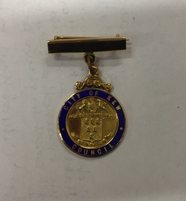
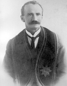
Badge - Identification Badge, Mrs HG Ferguson, Mayoress, City of Kew 1959-60, 1959
Hugh George Ferguson was born in June 1900 in Williamstown. After his family moved to Kew, they lived in Fernhurst Grove while his future wife’s family lived in Fellows Street. He married in 1940 and subsequently joined the Second AIF. In 1945, he was reported to be the ACF (Australian Comforts Fund) Commissioner in Borneo [Kalimantan]. After the Second World War, he worked as a Billeting Affairs Organiser for the Dutch Government, resettling migrants in Australia. He also worked in advertising as an account manager, and as campaign director for Arthur Rylah in Victorian politics. He directed the first major trade fairs at the Royal Exhibition Buildings after the Second World War, including ‘Australia Makes It Exhibition’ in 1947, the ‘Australian Industrial Fair’ in 1949 and 1950, the ‘Modern Home Exhibition’ in 1949, and ‘Made in Australia’ in 1952. The funds raised during the latter were earmarked for a ‘bankrupt’ Queen Victoria Hospital. He built a home in Brougham Street and represented North Ward on Kew Council from 1952 to 1968. He was elected Mayor in 1959. Hugh Ferguson died in 1975, aged 75. He was buried on 2 September in Grave 201, Special (Non- Denominational) Compartment A, Boroondara General Cemetery.A gold plated bar brooch with suspended medallion having a blue enamelled ring surrounding the City of Kew crest in reliefFront: City of Kew, above the city of Kew crest with Council below Rear: Mrs H. G. Ferguson, Mayoress, 1959-60city of kew, mayoresses - kew (vic), mrs hg ferguson -
 Kew Historical Society Inc
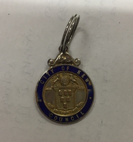
Badge - Identification Badge, Stoke, Cr HG Ferguson, City of Kew, 1955, 1955
Hugh George Ferguson was born in June 1900 in Williamstown. After his family moved to Kew, they lived in Fernhurst Grove while his future wife’s family lived in Fellows Street. He married in 1940 and subsequently joined the Second AIF. In 1945, he was reported to be the ACF (Australian Comforts Fund) Commissioner in Borneo [Kalimantan]. After the Second World War, he worked as a Billeting Affairs Organiser for the Dutch Government, resettling migrants in Australia. He also worked in advertising as an account manager, and as campaign director for Arthur Rylah in Victorian politics. He directed the first major trade fairs at the Royal Exhibition Buildings after the Second World War, including ‘Australia Makes It Exhibition’ in 1947, the ‘Australian Industrial Fair’ in 1949 and 1950, the ‘Modern Home Exhibition’ in 1949, and ‘Made in Australia’ in 1952. The funds raised during the latter were earmarked for a ‘bankrupt’ Queen Victoria Hospital. He built a home in Brougham Street and represented North Ward on Kew Council from 1952 to 1968. He was elected Mayor in 1959. Hugh Ferguson died in 1975, aged 75. He was buried on 2 September in Grave 201, Special (Non- Denominational) Compartment A, Boroondara General Cemetery.City of Kew identification badge issued to sitting councillors. The City of Kew cost is surrounded by a blue enamel band with City of Kew Council picked out in gold cloisonné.Front: City of Kew to top, Crest in middle with Council below Rear: Cr H. G. Ferguson 27-8-1955mayors of kew - cr hg ferguson, kew council, city of kew -
 Kew Historical Society Inc
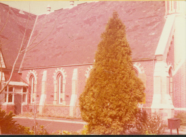
Photograph - Former Congregational Church, Walpole Street, H. Gielen, c.1977
The site of the former Kew Congregational Church was the earliest 'built' place of religion in Kew. An earlier building by Charles Vickers was replaced by a new brick church designed by Albert Purchas. Following the creation of the Uniting Church, the church at 30 Walpole Street was declared redundant and demolished to make way for the Bodalla Nursing Home (itself later demolished).Faded colour print positive of the former church in Walpole Street, Kew. The photo shows the north side of the church. "(Total of 5 photographs) / Reg No KH-137 / Former Congregational Church Walpole St. / Demolished 1979 / Build 1860 replaced the Independent Chapel 1854 / Donated by Hans Gielen, Kew Municipal Librarian 1979"kew congregational church, churches - kew (vic.), walpole street -- kew (vic.) -
 Kew Historical Society Inc
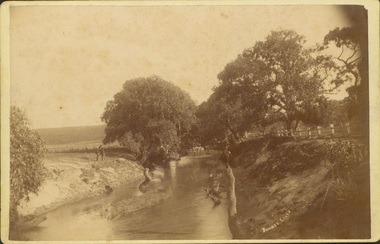
Photograph - Bryants Creek, Coleraine, 1892-3
This item is part of a larger collection donated to the Kew Historical Society by Anna French. The collection includes personal items from the donor's family, as well as items given to the donor and her mother by a family friend, Lucy Merritt (Jean) Hornby. The item is from that part of the collection inherited or assembled by Jean Hornby. The collection is significant given Jean Hornby's mother's descent from Robert Hornby (1854-1935) and Eva Merritt (1865-1959); her mother the chid of a family who settled in Kew in the 1850s, thus providing a chain of provenance for items dating to the mid-nineteenth century, when her maternal forebears arrived in Melbourne. Other items represent Jean Hornby's contribution to her local and wider community.Sepia photograph, labelled 'BRYANTS CREEK' at lower left. The creek is bordered by a white post and rail fence on one bank. On the other side of the creek are two men. The creek is bordered with remnant vegetation [ie Eucalypts]. Coleraine, in Western Victoria, was initially settled by Europeans in the 1840s. The developing township was aligned with Bryant's Creek with a north-south orientation. Reverse - Inscribed in ink: "Taken by H Bower with Student camera" / Printed: "C.G. Greenham Photographer, Hawthorn / The Herodotus Studio"bryants creek -- coleraine (vic.) -
 Kew Historical Society Inc
Plan - Tramway Estate, Camberwell North, 1937
Subdivision plans and real estate flyers/brochures reveal a number of aspects of urban development and history. The Kew Historical Society's collection of these plans, as well as advertisements extracted from magazines, cover key aspects of community development and architectural history of Kew and Kew Eat as well as surrounding suburbs. While most of the plans in the collection were gifted to the Society by the former City of Kew, a number of other plans and advertisements have been donated by individuals, of which this is an example.Single page subdivision plan listing properties for sale in the Tramways Estate, Camberwell North. The large estate was bounded by Doncaster Road, Burke Road, Marwan Avenue, Maud Street, Severn Street, and extended over Glass's Creek at Mayland's Avenue. Within the plan, lots 3 to 342 are listed as lots. The plan includes annotations in ink indicating the prices realised by a number of lots. A key explains that lots with an 'H' represent a house, whereas the 37 shaded lots represent those being offered by this agent. subdivision plans -- camberwell (vic.), tramways estate -
 Kew Historical Society Inc
Plan - Subdivision Plan, J R Mathers & McMillan, Clutha Subdivision, 1940
Pru Sanderson, in her groundbreaking ‘City of Kew Urban Conservation Study : Volume 2 - Development History’ (1988), summarised the periods of urban development and subdivisions of land in Kew. The periods that she identified included 1845-1880, 1880-1893, 1893-1921, 1921-1933, 1933-1943, and Post-War Development. These periods were selected as they represented periods of rapid growth or decline in urban development. An obvious starting point for Sanderson’s groupings involved population growth and the associated economic cycles. These cycles also highlighted urban expansion onto land that was predominantly rural, although in other cases it represented the decline and breakup of large estates. A number of the plans in the Kew Historical Society’s collection can also be found in other collections, such as those of the State Library of Victoria and the Boroondara Library Service. A number are however unique to the collection.The Kew Historical Society collection includes almost 100 subdivision plans pertaining to suburbs of the City of Melbourne. Most of these are of Kew, Kew East or Studley Park, although a smaller number are plans of Camberwell, Deepdene, Balwyn and Hawthorn. It is believed that the majority of the plans were gifted to the Society by persons connected with the real estate firm - J. R. Mathers and McMillan, 136 Cotham Road, Kew. The Plans in the collection are rarely in pristine form, being working plans on which the agent would write notes and record lots sold and the prices of these. The subdivision plans are historically significant examples of the growth of urban Melbourne from the beginning of the 20th Century up until the 1980s. A number of the plans are double-sided and often include a photograph on the reverse. A number of the latter are by noted photographers such as J.E. Barnes.The subdivision plan for the Clutha Subdivision is one of the largest in the Society’s collection. The plan includes a map of the proposed allotments, photographic views to the north and south, and information about the kinds of buildings that could be constructed on the allotments. The subdivision was bounded by Studley Park Road, and Carson, Stevenson and Edgecombe Streets. Two new streets, Mackie Court and Younger Street were created as part of the subdivision. The subdivision took its name from ‘Clutha’, the home of John Carson, who was to become Mayor of Kew in 1863. A Report to the City of Boroondara outlined how: ‘The Clutha estate was progressively developed from 1940, with new houses under construction on the Studley Park Road, Carson and Edgecombe Street frontages by 1941. By 1943, directory listings were available for all addresses with the exception of Mackie Court. Building ceased after the government’s prohibition on civilian building was enforced from 1942, with little change in listings until the 1950s when the remainder of the subdivision was developed’."H"subdivisions - kew - studley park, clutha subdivision, studley park road -
 Kew Historical Society Inc
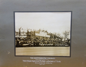
Photograph, Kodak (Australasia), The Kew "Strong Post" St Kilda Road, 1927, 1927
Apart from the photograph being of local interest to the history of Kew, it is also of interest as it was donated to the Kew City Council by Mr. C. R. du Rieu. Mr du Rieu was closely associated with the Kodak factory which purchased land in East Kew for a factory the plans for which were ultimately rejected by Council. In 1936, nine years after he donated the photograph to Council. Mr du Rieu died. A report in the Melbourne Age on 7 October 1936, p. 14 stated that: "Mr. Charles Richard du Rieu, of "Wonder View." 57 Pakington-street, Kew, formerly manager of the mount department of Kodak (Australasia) Pty. Ltd., died at his home on Tuesday morning at the age of 72 years. Born at Adelaide, Mr. du Rieu was the son of the late Mr. and Mrs. H. L. du Rieu. He is survived by his widow. For 43 years he had been associated with the late Mr. Thomas Baker, at the Kodak works. He retired from the firm in 1928. Among his charitable interests were the orthopoedic section of the Children's Hospital at Frankston, Eye and Ear Hospital, and the Fitzroy Ladies Work Association. He was president of the North Kew Progress Association, and a member of the Kew Bowling Club. In masonic circles he was a past master of the Kent Lodge, Melbourne, and a member of the Travellers' Washington Lodge. The burial will take place at the Boroondara Cemetery Kew, this afternoon. Arrangements are by Le Pine and Son Ltd."The photograph is of historic and social significance for what it tells of popular civic values in the interwar period in Melbourne and Australia which manifested itself on occasions such as Royal Visits.An unframed, mounted sepia photograph of the Kew "Strong Post" on St Kilda Road on the occasion of the Royal Visit of 1927.Caption: "The Kew "Strong Post" St Kilda Rd., / on the occasion of the visit of / Their Royal Highnesses the Duke and Duchess of York / presented by C.R. Du Rieu Esq / May 1927royal visit (1927), duke and duchess of york, the kew "strong post" 1927, st kilda road, kodak australasia pty ltd, charles richard du rieu -- wonder view -- 57 pakington street -
 Kew Historical Society Inc
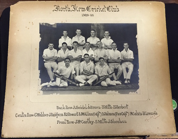
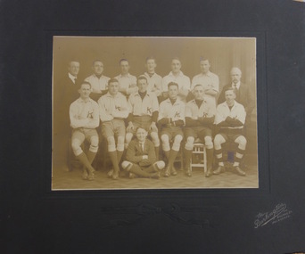
Photograph, Muntz, North Kew Cricket Club 1929-30, c. 1930
In 1996 when North Kew Cricket Club, which had the Bears as their emblem, merged with the Deepdene Cricket Club. The photograph is of local significance as an image of participation in sport and recreation in North Kew in the decade following the First World War.Photograph on paperboard of the North Kew Cricket Team of 1929-30. The names of the players are listed under the photograph.NORTH KEW CRICKET CLUB 1929-30 Back Row: A. Seidel | A. Brown | H. Wills | H. Herbert. Centre Row: C. Webber | J. Redfern | K. Stewart | A. McAllan (Captn) | A. Holmes (Vice Captn) | M. Colvin | V. Greaves. Front Row: J. McCarthy | S. Wills | J. Sheehan MUNTZ Malvernmuntz, north kew cricket club, a. seidel, a. brown, h. wills, h. herbert, c. webber, j. redfern, k. stewart, a. mcallan, a. holmes, mccolvin, v. greaves, j. mccarthy, s. wills, j. sheehan -
 Kew Historical Society Inc
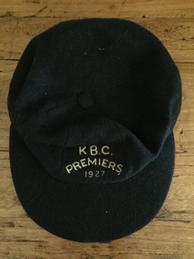
Uniform, K.B.C. Premiers 1927
The Victorian Baseball League was established in 1889 with the following clubs - MCC, Metropolitan, Richmond, Richmond Cricketers, Kew, Geelong, Fitzroy, The Age, Carlton, Coburg. MCC defeated Metropolitan for the first Premiership. By 1897 Kew had built up to six teams, but went into recess about the turn of the century. They reformed c.1906 and did not resume until 1926 under Captain/Coach Frank Littlefield. I think he was ex Hawthorn Baseball and/or Cricket club(s). They won the D Grade Premiership of 1926 and/or 1927 playing out of Victoria Park at 12 noon, and as a curtain raiser to either Kew or Kew District or East Kew Football Club and after World War 2, North Kew which had now joined Kew as a tenant. Team members were H.L. Barclay (ex Richmond), A. Brierley (ex Collingwood), H. Ely (ex Essendon), Frank Littlefield, J. Marshall and C. Robinson (ex Hawthorn-East Melbourne Cricket Club). In 1926, the KBC played against Caulfield, Fairfield, Fitzroy, Ivanhoe, Northcote, Prahran, University, Williamstown, YMCA. In 1927, Preston replaced Fairfield. A third team was formed post WW2 which played at Willsmere Park. The Reserves followed to Willsmere Park in 1963 and the Seniors in c.1970. Kew Council moved the club to a sub-standard Stradbroke Park No 2 Oval for the 1976 season and this proved to be the last for the club. Melbourne Baseball Club moved in for two seasons, but also moved when improvements to No 2 Oval were not made. They then moved to Macleay Park in a share arrangement with North Balwyn BC. Research: Ian Job, 2015A premiership cap awarded to Christopher Robinson of the Kew Baseball Club in 1927.Navy blue peaked baseball cap, embroidered in gold thread with K B.C. Premiers 1927sports uniforms, caps, premiership caps, baseball, -
 Kew Historical Society Inc
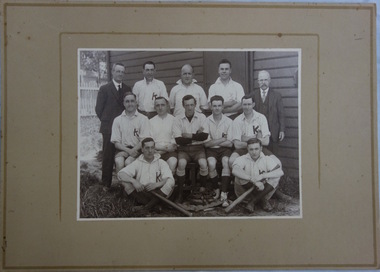
Photograph, Kew Baseball Club, c.1927
The Victorian Baseball League was established in 1889 with the following clubs - MCC, Metropolitan, Richmond, Richmond Cricketers, Kew, Geelong, Fitzroy, The Age, Carlton, Coburg. MCC defeated Metropolitan for the first Premiership. By 1897 Kew had built up to six teams, but went into recess about the turn of the century. They reformed c.1906 and did not resume until 1926 under Captain/Coach Frank Littlefield. I think he was ex Hawthorn Baseball and/or Cricket club(s). They won the D Grade Premiership of 1926 and/or 1927 playing out of Victoria Park at 12 noon, and as a curtain raiser to either Kew or Kew District or East Kew Football Club and after World War 2, North Kew which had now joined Kew as a tenant. Team members were H.L. Barclay (ex Richmond), A. Brierley (ex Collingwood), H. Ely (ex Essendon), Frank Littlefield, J. Marshall and C. Robinson (ex Hawthorn-East Melb Cricket Club). In 1926, the KBC played against Caulfield, Fairfield, Fitzroy, Ivanhoe, Northcote, Prahran, University, Williamstown, YMCA. In 1927, Preston replaced Fairfield. A third team was formed post WW2 which played at Willsmere Park. The Reserves followed to Willsmere Park in 1963 and the Seniors in c.1970. Kew Council moved the club to a sub-standard Stradbroke Park No 2 Oval for the 1976 season and this proved to be the last for the club. Melbourne Baseball Club moved in for two seasons, but also moved when improvements to No 2 Oval were not made. They then moved to Macleay Park in a share arrangement with North Balwyn BC. Research: Ian JobTeam photo of the Kew Baseball Club players and club officials and or supporters. The grandfather of the donor, Christopher Robinson has been identified as sitting in the middle row, 2nd from left.kew baseball club, victoria park -
 Kew Historical Society Inc
Photograph, The Burlington Studios, Kew Baseball Club, c. 1926
The Victorian Baseball League was established in 1889 with the following clubs - MCC, Metropolitan, Richmond, Richmond Cricketers, Kew, Geelong, Fitzroy, The Age, Carlton, Coburg. MCC defeated Metropolitan for the first Premiership. By 1897 Kew had built up to six teams, but went into recess about the turn of the century. They reformed c.1906 and did not resume until 1926 under Captain/Coach Frank Littlefield. I think he was ex Hawthorn Baseball and/or Cricket club(s). They won the D Grade Premiership of 1926 and/or 1927 playing out of Victoria Park at 12 noon, and as a curtain raiser to either Kew or Kew District or East Kew Football Club and after World War 2, North Kew which had now joined Kew as a tenant. Team members were H.L. Barclay (ex Richmond), A. Brierley (ex Collingwood), H. Ely (ex Essendon), Frank Littlefield, J. Marshall and C. Robinson (ex Hawthorn-East Melb Cricket Club). In 1926, the KBC played against Caulfield, Fairfield, Fitzroy, Ivanhoe, Northcote, Prahran, University, Williamstown, YMCA. In 1927, Preston replaced Fairfield. A third team was formed post WW2 which played at Willsmere Park. The Reserves followed to Willsmere Park in 1963 and the Seniors in c.1970. Kew Council moved the club to a sub-standard Stradbroke Park No 2 Oval for the 1976 season and this proved to be the last for the club. Melbourne Baseball Club moved in for two seasons, but also moved when improvements to No 2 Oval were not made. They then moved to Macleay Park in a share arrangement with North Balwyn BC. Research: Ian JobTeam photo of the Kew Baseball Club players and club officials and or supporters. The grandfather of the donor, Christopher Robinson has been identified as sitting in the back row, 2nd from left.kew baseball club, victoria park, christopher robinson -
 8th/13th Victorian Mounted Rifles Regimental Collection
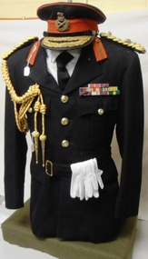
Uniform - Honorary Colonel Hammer, 1950 circa
This tunic and cap were worn by Major General H H (Tack) Hammer CBE DSO & Bar, ED when Honorary Colonel 8th/13th Victorian Mounted Rifles Regiment 1959-1960 Hammer had pre-WWII service with 8th Battalion and 17th Light Horse (Machine Gun) Regiment. He served with the 6th Division in North Africa and Greece before becoming Commanding Officer of 2nd/48th Battalion. On return from the Middle East, Hammer commanded the 15th Brigade throughout two years of fighting in New Guinea and Bougainville. After the war, Hammer became Commissioner for Repatriation in Victoria and continued his military career in the Citizens Military Forces, commanding the 2nd Armoured Brigade and later 3rd Division. Open-neck officer's 'Blues' tunic with gold braided general's epaulettes and Major General's embroidered badges of rank; gilt general's buttons; red and gold braided aiguillette and white gloves. Uniform worn by Major General H H (Tack) Hammer when appointed as Honorary colonel of 8th/13th Victorian Mounted Rifles. Medals awarded to Major General Hammer are Commander of the British Empire (CBE), Distinguished Service Order (DSO), Mentioned in Despatches (MID), 1939-45 Star, Africa Star, Pacific Star, Defence Medal 1939-45, British War Medal, Australian Service Medal 39-45, Queen Elizabeth Coronation Medal, Efficiency Decoration (ED). General's peak cap with gold bullion hat badge and double row of oak leaves on peak. Medals on display are replica.8/13 vmr, military, hammer, honorary, colonel, general, world war two, wwii, cmf -
 Glen Eira City Council History and Heritage Collection
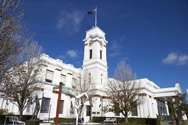
Photograph - Building, Glen Eira Town Hall, 1884
Originally known as Caulfield Shire Hall, the original 1884 building was designed by Shire surveyor Sydney Smith. In 1931 the Caulfield Town Hall, as it was then known, was remodelled to include the main hall and foyer and a Neo-Grecian portico with Corinthian Order columns. Major works completed since 1945 include Caulfield Arts Complex (opened 20 August 1988), Caulfield Library (opened 4 December 1993) and the award-winning Caulfield Municipal Offices extension which opened on 24 February 1991. The building is listed as No. H0106 in the GECC Heritage Overlay Schedule. The site also includes a Significant Tree (H&H Register No. 034). Brick exterior of two storey building painted white and featuring pillared portico entrance and solid glass doors on Glen Eira road facing north. On the eastern side of the portico is a two storey clock tower with clock surmounted by a flagpole and flag. Some of the eastern section of the building is original with various alterations over the years. The award winning service centre and offices in the westerly aspect of the town hall were extended on to the original buliding in 2000.building, town hall, council, local government, caulfield, glen eira, moorabbin, sydney smith -
 Surrey Hills Historical Society Collection
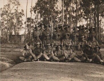
Work on paper - Photograph, The 2/1 Australian Field Butchery Platoon, Petrie, Queensland, 1945, 9 March 1945
This is an official group portrait of the 2/1st Field Butchery Platoon who are identified as: Left to right, back row: VX33117 Corporal (Cpl) F M Hogan; NX85618 Private (Pte) A J Nicol; VX127710 Pte E C J Kemp; VX143647 Lance Corporal (LCpl) L G Lobb; QX44905 Pte C L Adams; SX25540 Lance Sergeant R J Gray; NX193508 Pte K A Burgess; VX5112 Pte J T Roberts; NX153073 Pte D J Evans; WX9743 Pte M F Lynch. Middle row: QX49356 Pte L V Symes; QZ31697 Pte N R Underhill; QX16156 Staff Sergeant H L Cairns; VX19172 Lieutenant W H Thomas; VX55658 Sgt D W Craig; QX47082 Sgt E S Wilbraham; SX19778 Pte D Weatherald. Front row: NX155215 Pte E Corrigan; QX56335 Pte E Corrigan; NX57204 LCpl W H Jackson; VX59081 Pte B Moszkowicz; SX31901 Pte J Lambre; NX94941 Cpl R A Hanson; QX40009 Pte T G O’Neill; VX84971 Pte S J Welsh. The photo was taken under the command of 1 Aust Base Sub Area and Lt R B Irving. According to the Australian War Memorial website, the photographer was David Tennant Gaery Eastman and the photo was taken on 9 March 1945. In the AWM collection there is also a photo of members of the platoon at the unit slaughter yards in Milne Bay, New Guinea (REF: AWM 0703790). An overview of the history of the unit can be found at https://birtwistlewiki.com.au/wiki/2/1st_Field_Butchery_Company Leslie George Lobb, the father of the donor, was the platoon sergeant. He had multiple copies of this photo, which may have been obtained with the aim of distributing them to other platoon members. Leslie George Lobb - born 15 July 1920 in Box Hill; married Elizabeth Annie Stephenson in 1954; died 14 Nov. 1997. Leslie became a service station / garage proprietor at 352 Mont Albert Road, Mont Albert a business he took over from his father. An associated mechanical business operated under the name of Leo Green Motors, at the same address. The family lived next door at 354 Mont Albert Road, Mont Albert. Leslie's father Harry Lobb had operated at an adjoining property (350 Mont Albert Road, Mont Albert) as a fuel and ice merchant, before installing a petrol bowser to service the expanding motor car industry. The house at 354 Mont Albert Road, Mont Albert was removed and relocated by the family in 2000 to Mirboo North, Gippsland, Victoria, where it still stands.The photo is a touchstone to local servicemen who served in World War 2.A B&W / sepia photo with a narrow white border of 25 men in uniform. They are standing / sitting in 3 distinct rows with the rear row standing and the other 2 sitting on a 'sandy' area with sapling eucalypts and a (?) corrugated iron shed in the background.REAR: Purple photographer's stamp approximately in the centre: "Photograph No. MH [in lead pencil 87544] / Supplied by Military History / Section (S.D.9) / General Staff L H Q. / For personal enjoyment ONLY / and on condition that it will / not be reproduced in any form." f m hogan, a j nicol, c j kemp, l g lobb, c l adams, r j gray, k a burgess, j t roberts, d j evans, m f lynch, l v symes, n r underhill, h l cairns, w h thomas, d w craig, e s wilbraham, d weatherald, e corrigan, w h jackson, b moszkowicz, j lambre, r a hanson, t g o’neill, s j welsh, 2/1st field butchery platoon, petrie, world war, 1939-1945, mont albert -
 Stawell Historical Society Inc
Book, H. J. (Jim) Melbourne, North Western Woollen Mills And Norwellan Textiles, Stawel's Great Asset, 2007
North Western Woollen Mills became Norwellan Textiles then AUNDE -
 Surrey Hills Historical Society Collection
Book, Cricket at Canterbury: a centenary history of the Canterbury Cricket Club 1887-1987, c1987
A history of Canterbury Cricket Club from 1887. Each chapter dedicated to a decade through to the 1980's. Includes appendices and results, awards, achievements. 58p. photosA history of Canterbury Cricket Club from 1887. Each chapter dedicated to a decade through to the 1980's. Includes appendices and results, awards, achievements. 58p. photosFrontis page: Given to Surrey Hills Historical / Society 15/7/14 / Simon Gardiner(mr) simon gardiner, (mr) sid mackie, (mr) keith silvers, (mr) len larkin, (mr) clyde ingram, (mr) frank gion, cricket, sport, (mr) n nesbit, (mr) s bisset, (mr) w grubb, (mr) r falconer, (mr) f leach, (mr) - slater, "tuss" curtis, (mr) stan self, (mr) maurie webb, (mr) norm shores, (mr) geoff matthews, (mr) wally bates, (mr) t mackie, (mr) harry swan, (mr) r mcconchie, (mr) r vaux, (mr) a pearson, (mr) - walduck, (mr) mick maguire, (mr) bob trengrove, (mr) lindsay ridgwell, (mr) john mccarthy, (mr) ewan mccarthy, camberwell union cricket club, canterbury cricket club, (mr) s parry, (mr) w lauchlan, (mr) e yeomans, (mr) a cooper, (mr) h gates, (mr) - gittus, (mr) f sheppard, (mr) - walker, (mr) a abud, (mr) - bishop, (mr) a. leach, (mr) - edgoose, (mr) - allan, (mr) a brooks, (mr) c swan, reporter competition, north balwyn, mont albert, (mr) s stevens, (mr) j carlson, (mr) c yeo, (mr) e hosken, (mr) j smart, (mr) n booth, (mr) l warmbrun, (mr) w lachlan, deepdene, canterbury, box hill, surrey hills, eastern suburbs cricket assoc., (mr) t alway, (mr) k briggs, (mr) n thackeray, (mr) r rudd, (mr) r littlefield, (mr) (cr) r dimmick, (mr) g guiver, (mr) t cameron, (mr) ian coles, (mr) gerry hegarty, 1960-1969 -
 Surrey Hills Historical Society Collection
Book, Garnie's Army: the history of the Mont Albert Cricket Club, Jan-98
This is a club history of the Mont Albert Cricket Club.This is a club history of the Mont Albert Cricket Club.Presented to the S. H. Centre History by Dr. Greg McKiecricket, mont albert cricket club, garnie's army, (mr) (dr) greg mckie, sports and recreations, surrey hills golf club, north balwyn club, howard road methodist cricket teams -
 Surrey Hills Historical Society Collection
Book, Cricket at Canterbury: a centenary history of the Canterbury Cricket Club 1887-1987, c1987
A history of Canterbury Cricket Club from 1887. Each chapter dedicated to a decade through to the 1980's. Includes appendices and results, awards, achievements. 58p. photosA history of Canterbury Cricket Club from 1887. Each chapter dedicated to a decade through to the 1980's. Includes appendices and results, awards, achievements. 58p. photos(mr) simon gardiner, (mr) sid mackie, (mr) keith silvers, (mr) len larkin, (mr) clyde ingram, (mr) frank gion, cricket, sport, (mr) m nesbit, (mr) s bisset, (mr) w grubb, (mr) r falconer, (mr) f leach, (mr) - slater, "tuss" curtis, (mr) stan self, (mr) maurie webb, (mr) norm shores, (mr) geoff matthews, (mr) wally bates, (mr) t mackie, (mr) harry swan, (mr) r mcconchie, (mr) r vaux, (mr) a pearson, (mr) - walduck, (mr) mick maguire, (mr) bob trengrove, (mr) lindsay ridgwell, (mr) john mccarthy, (mr) ewan mccarthy, camberwell union cricket club, canterbury cricket club, (mr) s parry, (mr) w lauchlan, (mr) e yeomans, (mr) a cooper, (mr) h gates, (mr) - gittus, (mr) f sheppard, (mr) - walker, (mr) a abud, (mr) - bishop, (mr) a leach, (mr) - edgoose, (mr) - allan, (mr) a brooks, (mr) c swan, reporter competition, north balwyn, mont albert, (mr) s stevens, (mr) j carlson, (mr) c yeo, (mr) e hosken, (mr) j smart, (mr) n booth, (mr) l warmbrun, (mr) a webb, (mr) w lachlan, deepdene, canterbury, box hill, surrey hills, eastern suburbs cricket assoc., (mr) t alway, (mr) a briggs, (mr) k silvers, (mr) n thackeray, (mr) r rudd, (mr) c ingram, (mr) r littlefield, (mr) (cr) r dimmick, (mr) g guiver, (mr) t cameron, (mr) ian coles, (mr) gerry hegarty, 1960-1969 -
 Federation University Art Collection
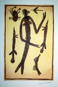
Work on paper - Artwork - printmaking, Lytlewode Press, A suite of limited edition prints by Paddy Fordham Wainburranga, 2003, 2003
Paddy Fordham Wainburranga (1932-2006) Area: Arnhem Land Country: Bamdibu (Bumdubu) near Bulman Station As a child, Paddy grew up in Maningrida an Aboriginal community on the top end of the Northern Territory. He started working as a boy around cattle yards, which finally led him to working as a stockman for 20 years. Before this, he spent much of his time hunting and learning culture and customs from his father and uncles. He could remember being taken to a sacred location where he was told many Dreamtime stories of how customs came to be and why Aboriginal people practice them. Paddy was part of the movement for equal rights for all Aborigines, actively involved in claiming Bumdibu as his traditional land for his clan. He resided over this land as Jungai (caretaker, policeman). Paddy was taught to paint by his father but did not begin to paint seriously until the early 1970s. He was also recognized as a story teller, bark painter, sculpture, dancer, singer and musician. He was familiar with Central Arnhem Land rock and bark painting traditions; however he developed an idiosyncratic style which fused the figurative schema of western Arnhem Land with the narrative capacities of the north-east producing dense pictorial paintings divided into sequential segments. A suite of seven limited edition prints using the sugar lift aquatint technique. .1) Yalk Yalk Woman Sugar Lift Aquatint Plate 75.0cm (H) x 49.0cm (W) Paper 1110cm (H) x 76.0cm (W) 2003 Edition: 73/100 .2) Walga Walga Sugar Lift Aquatint Plate 75.0cm (H) x 49.0cm (W) Paper 1110cm (H) x 76.0cm (W) 2003 Edition: 73/100 .3) Nammooroddoo Sugar Lift Aquatint Plate 75.0cm (H) x 49.0cm (W) Paper 1110cm (H) x 76.0cm (W) 2003 Edition: 73/100 Nammooroddoo Sugar Lift Aquatint Plate 75.0cm (H) x 49.0cm (W) Paper 1110cm (H) x 76.0cm (W) 2003 Edition: 73/100 .3) Nammooroddoo Sugar Lift Aquatint Plate 75.0cm (H) x 49.0cm (W) Paper 1110cm (H) x 76.0cm (W) 2003 Edition: 73/100 .4) Mun Gruk Gruk Woman Sugar Lift Aquatint Plate 75.0cm (H) x 49.0cm (W) Paper 1110cm (H) x 76.0cm (W) 2003 Edition: 73/100 .5 Mun Gruk Gruk Man Sugar Lift Aquatint Plate 75.0cm (H) x 49.0cm (W) Paper 1110cm (H) x 76.0cm (W) 2003 Edition: 73/100 .6) Mun Gruk Gruk Sugar Lift Aquatint Plate 75.0cm (H) x 49.0cm (W) Paper 1110cm (H) x 76.0cm (W) 2003 Edition: 73/100 .7) Lightning Man Sugar Lift Aquatint Plate 75.0cm (H) x 49.0cm (W) Paper 1110cm (H) x 76.0cm (W) 2003 Edition: 73/100 Donated through the Australian Government Cultural Gifts Programme by Katherine N. Littlewood, 2014artist, artwork, paddy fordham wainburranga, paddy fordham, wainburranga, printmaking, aboriginal, indigenous, churchill, dreaming -
 Surrey Hills Historical Society Collection
Photograph, Samuel Bolton in Druid's regalia, 1950
Samuel Bolton of 244 Union Road, Surrey Hills in his 'Druid's Collar' in 1950. Samuel and his son-in-law Patrick Burns were staunch Druids. The Lodge met monthly in the Rechabite Hall in Canterbury Road. The United Ancient Order of Druids (UAOD) was founded in Victoria around 1862. An account is included in Ken James' book 'Surrey Hills Friendly Societies'. This is based on Box Hill Reporter articles and material in relevant files at PROV. Summary: The Surrey Hills Lodge was established in 1890. The trustees were Ernest W Opperman (newsagent), James H Corstorphan (grocer) and Thomas White (plasterer). Opening night was 27 November 1890 and early meetings were held in Br Corstorphan's home in Canterbury Road on Tuesday evenings. By 1891 the ledge had 80 members. Samuel (1978-1951) was a butcher who came to Surrey Hills from Euroa some time between 1926-1931. His shop was at the Mon Albert terminus. After he sold it, it became part of the supermarket on the north side of Whitehorse Road. He was married in 1879 to Elizabeth Beatrice Maker (1881-1963).A black and white photograph of a man with regalia collar around his neck.(mr) samuel bolton, union road, surrey hills, druids, rechabite hall, clothing and dress, united ancient order of druids, druid's regalia, regalia, friendly societies -
 Surrey Hills Historical Society Collection
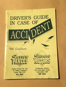
Booklet - Advertising booklet, Driver's guide in case of accident, c1991
Surrey Panels was started by Maurice Dalzell (Maurie) Costello (1918-2000) in 1948, soon after the first Holden was released. Maurie later brought his sons Alan, Robert and Brian into the business. F H Stevens Motors started in North Balwyn at a similar time and in 1982 was taken over by the Costello brothers, with Robert as General Manager. Members of the Costello family have been around the Surrey Hills area for many decades. Maurie’s parents Thomas Maurice and Mabel Isabel Costello lived at 43 Box Hill Crescent, Mont Albert North. Thomas was a cattle dealer and related to the Costellos of Costello’s Jersey Dairy (demolished) in Mont Albert Road, Balwyn. Prior to starting the business Maurie is listed as a market gardener living with his parents in Box Hill Crescent. He married Mavis Jean Guillerme in 1942. Surrey Motors and Surrey Panels are well known businesses serving the Surrey Hills community for decades.A small booklet, yellow in colour, designed to fit in the glove box of a car. It is stapled on the spine in 2 places and consists of 12 pages. Some pages are designed for the owner to fill in with their personal details. There is advice regarding emergency phone calls, what to do in the event of an accident, towing, 'at fault' information, insurance, location and services of Surrey Panels and F H Stevens Motors. There is a brief history of these linked businesses. There is a separate loose sheet designed to be completed in the event of an accident.Nilsurrey motors, surrey panels, maurice dalzell (maurie) costello, f h stevens motors, alan costello, robert costello, brian costello, canterbury road, stirling crescent, surrey hills, ephemera, car accidents, motor vehicle repairs -
 Federation University Art Collection
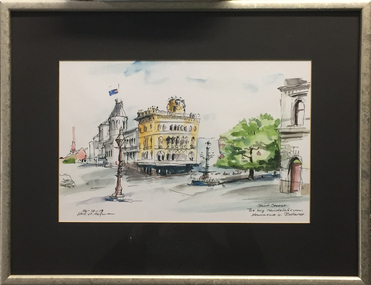
Work on paper - Artwork - watercolour, Karl H. Hofman, 'Sturt Street: The big candleabrum monuments in Ballarat' by Karl H. Hofman, 19/10/2002
Framed watercolour of a Ballarat street scene painted from Lydiard Street North looking towards Craig's Royal Hotel.karl h hofman, ballarat, craig's royal hotel, lamp, burke and wills fountain -
 City of Greater Bendigo - Civic Collection
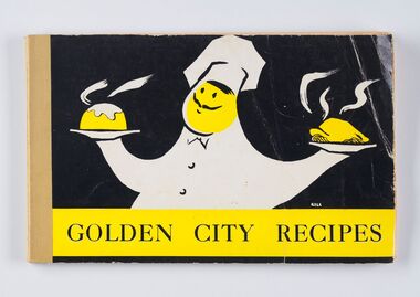
Book - Cookbook, The Neale Street North Pre-School Mothers' Club Committee, Golden City Recipes, 1963
This cookbook was compiled by the Neale Street North Pre School Mothers' Club Committee with the forward written by Anne Galvin O.B.E, President of the Bendigo & District Pre-school Association. Anne Galvin was one of Bendigo's best known charity workers and she used her first speech as Mayoress (1944) to indicate her intentions to assist mothers and children. This recipe book includes contributions by the Mayoress of the day (Mayoress Rae), Television Hostesses Corinne Kirby and Ruth Nye and Mrs Bolte and Lady Brooks. Illustrator of front cover unknown.Bound and printed cookbook containing one hundred and eight pages of recipes and advertisements including forward written by Anne E. Galvin. Colour cover, stapled on left hand side. Advertisements for local businesses include Gordon H. Hall Beauty Salon, Gas and Fuel Corporation, Hesse Bros. Electrical and Sandhurst Milk & Cream, Recipe categories include: By Special Request; Soups; Sea Foods; Meat and Poulty (sic) Dishes; Hot Sweets and Puddings; Cold Sweets; Meals in a Hurry; Salads and Dressings; Savouries and Fillings, Icings, etc; Cakes Large and Small, Biscuits; Scones, Buns and Loaves; Jams, Pickles and Preserves; Gravies and Sauces; Confectionery; Weights and Measures; Index to Advertisers; Beauty Hints. city of greater bendigo education, city of bendigo mayoress, mayoress galvin, mayoress rae, cambridge press, mayor w cambridge, anne galven -
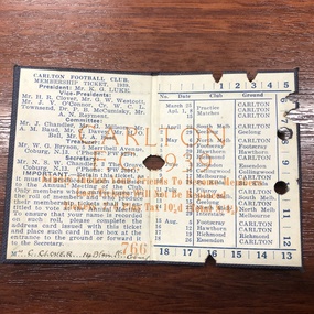 Carlton Football Club
Membership Ticket, 1939 Carlton FC Membership Ticket, 1939
1939 Carlton FC Membership TicketCarlton FC Membership Ticket 1939 Season depicts VFL fixture Carlton Board for 1939 & members name & address Mrs C Clover 14 Blair Pl Coburg. Membership No. 766. The member maybe related Vice President of the club H R Clover.Small Card Board Ticket -
 Carlton Football Club
Membership Ticket, 1939 Carlton FC Membership Ticket, 1939
Membership Ticket Carlton FC 1939Carlton FC Membership Ticket 1939 Season depicts VFL fixture Carlton Board for 1939 & members name & address Mrs C Clover 14 Blair Pl Coburg. Membership No. 765. The member maybe related Vice President of the club H R Clover.Small Cardboard Ticket -
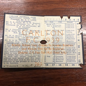
 Carlton Football Club
Membership Ticket, 1940 Carlton FC Membership Ticket, 1940
1940 Carlton FC Membership TicketCarlton FC Membership Ticket 1940 Season depicts VFL fixture Carlton Board for 1940 & members name & address Mrs C Clover 14 Blair Pl Coburg. Membership No. 1199 The member maybe related Vice President of the club H R Clover.Small Cardboard Ticket four pages -
 Carlton Football Club
Membership Tickets, 1943 Carlton FC Membership Ticket, 1943
1943 Carlton FC Membership TicketCarlton FC Membership Ticket 1943 Season depicts VFL fixture Carlton Board for 1943 & members name & address Mrs C Clover 14 Blair Pl Coburg. Membership No. 1181. The member maybe related Vice President of the club H R Clover.Small Cardboard Ticket Four PagesCarlton FC Membership Ticket 1943 Season depicts VFL fixture Carlton Board for 1943 & members name & address Mrs C Clover 14 Blair Pl Coburg. Membership No. 1181. The member maybe related Vice President of the club H R Clover. -
 Carlton Football Club
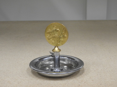
Commemorative Ash Tray, 1947 VFL Awarded to H O Bell Secretary of Carlton FC 1947, 1947
Presented to Carlton FC secretary H O Bell in recognition of Carlton's 1947 premiershipThe awarded trophy although for the 1947 season was passed onto former Carlton player Cyril Mann who missed selection for the 1945 Grand Final (The Blood Bath) victory over South Melbourne. Cyril Mann's maternal Grandfather William Cooper "is remembered as the Australian Aboriginal political activist, much-respected community leader and genuine man of stature whose extraordinary lifetime achievements cannot be properly acknowledged in the limited space available here". Tony De Bolfo 2013.Comprises stainless steel & bronze. Small bronze medallion sits atop ash tray on a small pedestal."Awarded to H O Bell Secretary Carlton Football Club 1947 PREMIERS" The VFL emblem is depicted on one side of the medallion. -
 Carlton Football Club
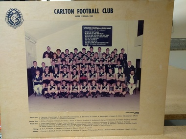
Team photograph, Under 19 squad 1985, 1985
Under 19 squad 1985, players and officials. Back Row: K. Newman (committee), H. Sternfield (Physiotherapist), G. Zaharakis, B. Comben, A. MacDougall, A. Basset, G. Warry (Development Officer), A. MacKinnon, S. Potter, D. Castledine (Committee). Centre Row: J. Clifton (Trainer), P. Merson, M. Hailes, J. Smith, P. Albon, P. Starbuck, S. McMahon, B. Carter, H. Hetherton, W. Gilbert (Property Steward). Front Row. L. Jones (Head Trainer), R. Skein (Team Manager), J. Vincent (Committee), J. Hullin, B. Whitmore, D. Forbes, W. Burke, C. Thomson, D. Bolzonello (Doctor), J. Baker (Phys. Ed.), A. Espie (Committee), T. McLeod (Trainer), I. Aitken, M. Edwards, J. Dunlop, G. Southby (Coach), M. Hanna (Captain), D. McKay (Assistant Coach), P. Higgins, K. Rainsford, R. Lowrey, R. Walllis (Trainer). Sitting: G. Buck, W. Pepper, J D'Angelo, D. O'Farrell, J. Coburn, J. Cook, K. Lamont. Absent: L. Brunier, A. Dodds, S. Driscoll, D. Fitzgerald, M. Gallagher, G. Hatvani, P. Poursanidis, P. Ricci, A. Scott, D. Zerna, P. Wilkinson, S. Ralph, S. Willox. Note, much of club's correspondence records name as Roger Skien, not Skein as listed above.Includes a number of players who went on to play senior footballColour photograph mounted on cardboard backing. -
 Carlton Football Club
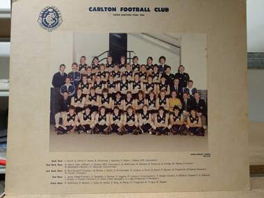
Colour photograph, Under 19 team 1984, 1984
From Roger Skien Collection. Back Row: J. Smith, D. Zerna, P. James, B. Whitemore, J. Rainone, P. Albon, J. Baker (P.E. Instructor) 2nd Back Row: G. Warry (Development Officer), J. Stevens (P.E. Instructor), A. McKinnon, G. Hatvani, P. Starbuck, D. Forbes, M. Hanna, P. Cronin, D. Bolzonello (Doctor), K. Newman (Committee). 3rd Back Row: R. Shuttleworth (Trainer), W. Burke, J. Hullin, D. Krittemeyer, R. Lowery, A. Price, G. Evans, P. Muscat, N. Fitzpatrick (Property Steward), H Turner (Trainer) 2nd Row: L. Jones (Head Trainer), D. Nardella, J. Dunlop, P. Higgins, P. Lumicisi (Vice Captain), T. Keogh (Coach), S. Baldwin (Captain), S. Glasscott, I. Aitken, J. Vincent (Runner), R. Skien (Team Manager), A. Lugg (Treasurer, Time keeper). Front Row: P. Wilkinson, P Merson, J. Cook, M. Hailes, S, Gray, S. Potter, D. Fitzgerald, M. Turgut, W. Pepper.Colour team photograph mounted on cardboard