Showing 2560 items matching " photo notes"
-
 Greensborough Historical Society
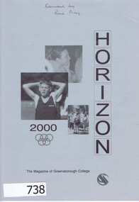
School Magazine, Horizon 2000: The magazine of Greensborough College Gr8750, 2000_
Each year, the college yearbook reports on the people (students and staff) and events and activities that took place that year. Note: In 1989, Watsonia High School was merged with Watsonia Technical School to become Greensborough Secondary College.A permanent record of who attended Greensborough College - both student and teachers, includes photographsAnnual record of teaching staff, students and events that took place in 2000. Includes black and white and colour photos and reports. 44 pages. Cover depicts students and the Olympic rings.In pen on front cover: "Donated by Rosie Bray"greensborough college, yearbook, horizon, school magazines, greensborough secondary college -
 Greensborough Historical Society
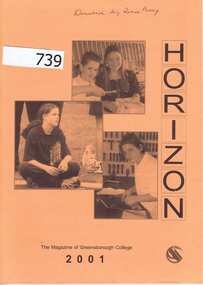
School Magazine, Horizon 2001. The magazine of Greensborough College Gr8750, 2001_
Annual record of teaching staff, students and events that took place in 2001. Each year, the college yearbook reports on the people (students and staff) and events and activities that took place that year. Note: In 1989, Watsonia High School was merged with Watsonia Technical School to become Greensborough Secondary College.A permanent record of who attended Greensborough College - both student and teachers, includes photographs. 60 pages. Includes black and white and colour photos and reports. Cover depicts students.In pen on front cover: "Donated by Rosie Bray"greensborough college, yearbook, horizon, school magazines, greensborough secondary college -
 Greensborough Historical Society
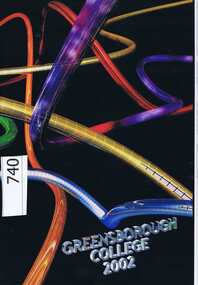
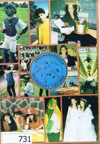
School Magazine, Greensborough College 2002 Gr8750, 2002_
Annual record of teaching staff, students and events that took place in 2002. Each year, the college yearbook reports on the people (students and staff) and events and activities that took place that year. Note: In 1989, Watsonia High School was merged with Watsonia Technical School to become Greensborough Secondary College. Previous editions of this yearbook were called 'Horizon'.A permanent record of who attended Greensborough College - both student and teachers, includes photographs. 68 pages. Includes black and white and colour photos and reportsIn pen inside front cover: "Donated by Rosie Bray"greensborough college, yearbook, horizon, school magazines, greensborough secondary college -
 Greensborough Historical Society
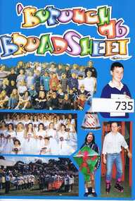
School Magazine, 'Borough Broadsheet 96. Gr8750, 1996_
Annual record of teaching staff, students and events that took place in 1996. Each year, the college yearbook reports on the people (students and staff) and events and activities that took place that year. Previous editions of this yearbook were titled "Horizon". Note: In 1989, Watsonia High School was merged with Watsonia Technical School to become Greensborough Secondary College.A permanent record of who attended Greensborough College - both student and teachers, includes photographs36 Pages (approx.) Includes black and white photos and reports., Colour cover includes photos of students.In pen inside front cover: "Donated by Rosie Bray"greensborough college, yearbook, horizon, school magazines, watsonia high school, watsonia technical school -
 Greensborough Historical Society
School Magazine, Greensborough Secondary College Yearbook 1993 Gr8750, 1993_
Each year, the college yearbook reports on the people (students and staff) and events and activities that took place that year. Previous editions of this yearbook were titled "Horizon". Note: In 1989, Watsonia High School was merged with Watsonia Technical School to become Greensborough Secondary College.A permanent record of who attended Greensborough College - both student and teachers, includes photographs. Annual record of teaching staff, students and events that took place in 1993. Includes black and white and colour photos and reports. 40 Pages (approx), Cover graphic is a collage of student photos. 2 copies.In pen inside front cover: "Donated by Rosie Bray"greensborough college, greensborough secondary college, yearbook, horizon, school magazines -
 Greensborough Historical Society
School Magazine, Greensborough Secondary College Yearbook 1994 Gr8750, 1994_
Each year, the college yearbook reports on the people (students and staff) and events and activities that took place that year. Previous editions of this yearbook were titled "Horizon". Note: In 1989, Watsonia High School was merged with Watsonia Technical School to become Greensborough Secondary College.A permanent record of who attended Greensborough College - both student and teachers, includes photographs. Annual record of teaching staff, students and events that took place in 1994. Includes black and white and colour photos and reports. 36 Pages (approx), Cover is a collage of student photos and artwork.In pen inside front cover: "Donated by Rosie Bray"greensborough college, greensborough secondary college, yearbook, horizon, school magazines -
 Greensborough Historical Society
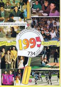
School Magazine, Greensborough Secondary College Yearbook 1995. Gr8750, 1995_
Annual record of teaching staff, students and events that took place in 1995. Each year, the college yearbook reports on the people (students and staff) and events and activities that took place that year. Previous editions of this yearbook were titles "Horizon". Note: In 1989, Watsonia High School was merged with Watsonia Technical School to become Greensborough Secondary College.A permanent record of who attended Greensborough College - both student and teachers, includes photographs. 50 Pages (approx.) Includes black and white and colour photos and reports., Cover includes a collage of student photos.In pen inside front cover: "Donated by Rosie Bray"greensborough college, greensborough secondary college, yearbook, horizon, school magazines, watsonia technical school, watsonia high school -
 Greensborough Historical Society
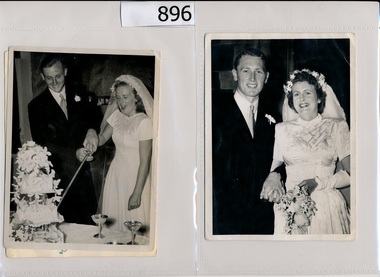
Photographs, Cordner family, 30/10/1947
Photographs of members of the Cordner family of Greensborough. Wedding photos of Donald and Moyle Cordner, Denis and Pat Cordner and photo of child Edward Baillieu Cordner aged 10 months. [Note: on 4/2/1947 Stubbs-Cordner. - Moyle Dewhurst, younger daughter of Mr. and Mrs. J. F. Stubbs, View Street, Bendigo, to Donald Pruen, second son of Dr. and Mrs. E. R. Cordner, Ashmead, Greensborough. Wedding details published in The Age on 30/10/1947] The Cordner family lived at "Ashmead" in Greensborough and members of the family were the local doctors.3 original black and white photographs.Captions written on back of each photograph.cordner family, donald cordner, denis cordner -
 Greensborough Historical Society
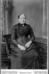
Photograph - Digital image, Leah Partington in Heywood, 1856c
... a daughter, Maria, born in 1851. Leah was 25 and unmarried. (notes.... Leah was 25 and unmarried. (notes by Faye Fort). Photo taken ...Portrait of Leah Partington (born 1826), sister of Charles Partington who left for Australia the next year in 1857. Leah had a daughter, Maria, born in 1851. Leah was 25 and unmarried. (notes by Faye Fort). Photo taken in Heywood England.Digital copy of black and white studio photograph.partington family -
![Photograph - Digital image, Willis Vale [2], 1950c](/media/collectors/4f729f5697f83e03086015b8/items/54fd41442162f10d30bf885f/item-media/54fd41912162f10d30bf8caa/item-fit-380x285.jpg) Greensborough Historical Society
Greensborough Historical SocietyPhotograph - Digital image, Willis Vale [2], 1950c
View of Greensborough in the distance from Willis Vale and surrounding land: House built by Edward Maygar, The flowering Hawthorne Bushes were planted by William Partington. Note the prominent house on upper right where Robert Whatmough lived in the mid 19th century and later sold to Partington family. It was located on the Plenty River across from Partington's Flat. The derelict Willis Vale house was destroyed in 1964 when a fire originating from North Plenty Gorge - Kurrak Road - was lit by two teenage boys and made its way several kilometres down to Partington's Flat Greensborough. In 1946, Alan Partington built the Alwyn Farmhouse in place of the original Robert Whatmough home seen in this photo which became Whatmough Park circa 1976.Home of the Partington familyDigital copy of black and white photograph.willis vale, partington family, maygar family, whatmough -
 Greensborough Historical Society
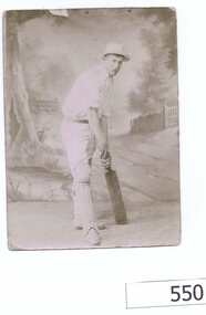
Photograph (copy), William James Partington 1872-1941, 1892c
... batting pose. Note on back of photo states that William... Partington in a cricket batting pose. Note on back of photo states ...The photograph shows William Partington in a cricket batting pose. Note on back of photo states that William was captain of a Greensborough cricket team playing against an English team.This was taken after Greensborough Cricket Club had played a game against a visiting English cricket team.A black and white copy of a photograph.Hand written notes on the back of the copy.cricket, greensborough cricket club, partington, william partington -
 Greensborough Historical Society
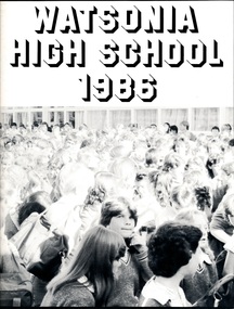
School Magazine, Watsonia High School Yearbook 1986 WaHIGH, 1986_
Annual record of teaching staff, students and events that took place over the year by using both photos and reports. Headmaster / Principal - Mr. Don GrantA permanent record of who attended Watsonia High School - both student and teacher in 1986 - includes photographs. Note change of name from Kurnaji (previous yearbooks).Pages not numbered, white cover, Title "Watsonia High School 1986" in Black ink. Contains text and graphics. Cover illustration – black and white photograph.. watsonia high school, yearbook, kurnaji, school magazines -
 Greensborough Historical Society
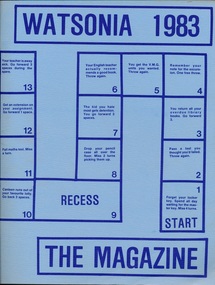
School Magazine, Watsonia 1983 The Magazine WaHIGH, 1983_
Annual record of teaching staff, students and events that took place over the year 1983 by using both photos and reports. Headmaster / Principal - Mr. Don GrantA permanent record of who attended Watsonia High School - both student and teacher in 1983 - includes photographs. Note change of name from Kurnaji (previous yearbooks).Pages not numbered, blue cover, Title "Watsonia 1983 The Magazine" in blue ink. Contains text and graphics. Cover illustration – stylised board game depicting the school day. 2 copies. One copy has 'M.Willimott' written in pencil on cover.watsonia high school, yearbook, kurnaji, school magazines -
 Greensborough Historical Society
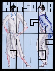
School Magazine, Watsonia High 1985. WaHIGH, 1985_
Annual record of teaching staff, students and events that took place over the year by using both photos and reports. Headmaster / Principal - Mr. Don GrantA permanent record of who attended Watsonia High School - both student and teacher in 1985 - includes photographs. Note change of name from Kurnaji (previous yearbooks).Pages not numbered, blue cover, Title "Watsonia High 1985" outlined in Black ink. Contains text and graphics. Cover illustration – fashion sketches.watsonia high school, yearbook, kurnaji, school magazines -
 Glenelg Shire Council Cultural Collection
Postcard - Postcard - Featuring Victorian Lighthouses, c. 2000
Contemporary postcard of Victorian lightbouses. 4 rectangular and one oval full coloured photos of lighthouses at Point Lonsdale, Aireys Inlet, Cape Nelson, Port Fairy and Cape Otway. 'Lighthouses Great Ocean Road, Victoria Australia' in white on black, bottom margin. Travellers notes logo on right. -
Glenelg Shire Council Cultural Collection
Souvenir - Programme - Wood Wine and Roses Festival 2013, c. 2013
Official program, 2013 Heywood Wood, Wine and Roses Festival. 32 page booklet, pages edged in green, program and advertisements in colour, front cover dark green, photo of wood chop , image of wineglass with red roses, gold stave and musical notes, rose petals. 20th anniversary issue. -
Glenelg Shire Council Cultural Collection
Photograph - Photograph - Portland Harbour, n.d
Black and white photo of Ocean Pier, Portland, taken from the beach. Steamship berthed on outside of pier. Groups of people walking out on pier. Remains of baths on left, section of Fishermen's Pier on right.Front: 'The Pier, Portland' - in white, bottom right Back: Handwritten note from Glad to Mr. W. Vivian Snr.portland harbour, ocean pier, public baths, steamship, vessel -
Glenelg Shire Council Cultural Collection
Map - Brochure/Map - Great South West Walk, Oct-83
Brochure/map. Great South West Walk. Track notes for the walk on one side, map showing Great South West Walk on the other, white with blue print and images; map multi-coloured. Front of brochure has photo of Shelley Beach, in blue and white, yellow print, yellow GSWW logo. Back cover yellow, black print. Contact details.great south west walk -
 Greensborough Historical Society
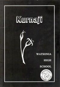
School Magazine, Kurnaji 1989. Watsonia High School Yearbook WaHIGH, 1989_
A permanent record of Who attended Watsonia High School - both student and teacher in 1989 - includes photographs. Note: This was the last year of publication of Kurnaji as Watsonia High School was merged with Watsonia Technical School to become Greensborough Secondary College.Annual record of teaching staff, students and events that took place over the year by using both photos and reports. Includes Roll Call section with names of all students. 3 copies50 Pages (approx), Black cover, Title "Kurnaji" in White ink.watsonia high school, yearbook, kurnaji, school magazines -
 Halls Gap & Grampians Historical Society
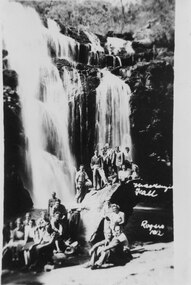
Photograph - B/W, C 1930s
This photo was taken by Gilbert Rogers, a well known local photographer of the day. Note that the inscription says MacKenzie Fall with no "s".Photo shows a large group (twenty two people) posed on rocks at the base of a large waterfall (MacKenzie Falls)."Mackenzie Fall Rogers 1(?)12" inscibed lower right of photo.scenery, mackenzie falls -
 Halls Gap & Grampians Historical Society
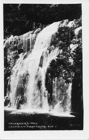
Photograph, Oct-27
The photo was taken by Gilbert Rogers, a well known local photographer. Note that the inscription says MacKenzie Fall with no "s".A photo of a large waterfall (MacKenzie Falls) taken from the lower right side."MacKenzie's Fall. Grampians Mountains. 306 J" inscribed on lower left of photo. "Rogers" inscribed on lower right of photo.scenery, mackenzie falls -
 Halls Gap & Grampians Historical Society
Photograph - B/W, C 1920s
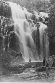
The man in the white hat is Freddy Paasch and the other man is Charles D'Alton. Note that names have been inscribed on the rock on the lower right side of the photo (visible only on Copy 1). The second copy is available under Additional Images.The photo shows two men (Freddy Paasch and Charles D'Alton), accompanied by a dog, standing at the base of, and looking up at, a large waterfall (MacKenzie Falls).scenery, mackenzie falls, people, d'alton -
 Halls Gap & Grampians Historical Society
Photograph, C 1920s
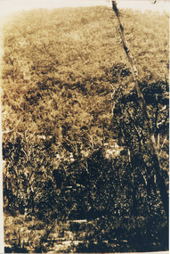
This is a photo of the Mt. Victory Road under construction. The workers camp can be seen in front of the road. For further information see 'Victoria's Wonderland', pp 102, 112 & 136. Note: The second copy is a transparency held at Slide Box No. 162.The photo shows a slope covered in thick bush. A road can just be seen in the middle foreground and a campsite with many tents can be seen through the bush in front of the road.access routes, mt victory rd -
 Halls Gap & Grampians Historical Society
Photograph - B/W, C 1960s
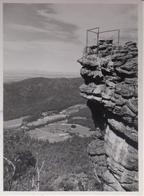
Lookout is known as 'The Pinnacle'. Valley is the Fyans Valley.Photo shows rocky outcrop surrounded by a wire fence and overlooking a valley with roads,some cleared areas and buildings. The Mt. William range can be seen middle left in the photo.On back notes "bellfield' but neither Bellfield Peak or Bellfield lookout can be seen.scenery, lookouts -
 Ararat & District Historical Society (operating the Langi Morgala Museum)
Barkly Street, Ararat, perhaps 1870s
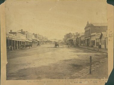
This is one of a dozen or so pictures of very early Ararat held by Langi Morgala Museum, and can be compared to a succession of later photographs to illustrate the growth of the town of Ararat. The date suggested by the inscription on the front is probably a reference to some other occurrence, since the street seems far to built-up for 1856-1860. The date is more likely the 1870s, or even the 1880sThis photograph, though not in good condition, is one of the few in the possession of Langi Morgala Museum that shows very early Ararat. It is of regional significance, which would be enhanced if a firmer date could be established. This cardboard-mounted large photograph is not in very good condition, but some parts of the image are still clear. There are permanent inscriptions on both front and back, not done in sympathy with the age and importance of the item.On front: "Note hitching posts and the old Turf Hotel, Barkly Street cont[illegible] / 1856-60". On back: museum stamp and photo numbers.barkly-street, ararat, horse, horse-driven, early-ararat, business, commercial -
 Eltham District Historical Society Inc
Photograph, Spring Excursion, Hume and Hovell bus tour Stage 2, Seymour, Benalla; 26 Oct 1997, 26/10/1997
MONUMENT HUNTING THE HUME AND HOVELL WAY (Newsletter No. 117, November 1997, by Diana Bassett-Smith) Sunday October 26 1997 dawned bright and very warm. Some twenty-five members, complete with picnic baskets, met outside the Eltham Library awaiting the Cobb and Co. large coach which would be taking us on the second leg of our travels along the route of the early explorers Hume and Hovell. Stephen West was our very good driver for the day. He would be guided around the circuitous route by Russell Yeoman wh9 had made a detailed study, not only of the intended route, but of the story of these two explorers. During the trip Russell regaled us with poetry, quotations from the Journals and the History of the Shire of Seymour, "The New Crossing Place: by Martindale, 1982, (now Mitchell Shire due to the recent amalgamations). We headed towards the Hume Highway via Greensborough and Cooper Street and proceeded north to our first stop, noting on the way Monument Hill in the distance which is near Kilmore and, according to Russell, well worth the effort to visit as the view across the valley is magnificent. Past Sunday Creek Valley, Mt Piper and Mt Disappointment, all traversed and noted and named by them. We passed through Tallarook, then onto Seymour where we took photos of the monument telling us that Hume and Hovell had passed through on the 28th of October 1824. We also deviated down Hume and Hovell Road viewing deer and emu farming and the Bellbourie property now a sanctuary. Leaving Seymour behind we travelled up the Avenel Road to the Avenel monument, pyramidal in design of four reducing square blocks with a sharply pointed peak, erected in 1924 in memory of the 1824 exploration. The day was warming up and the countryside showing the dryness of the current drought. A parallel note had been made in their journal too of 1824 of the drought appearance of the country they were traversing. At Seven Creeks, Euroa we stopped for some minutes to check the monument placed 20th November 1924 to commemorate their passage on the 29th December 1824. More photos. Russell had pointed out the abrupt termination of the distant ranges which is noted in their journal. The next monument is beside the road at the entrance to Honey Suckle Creek Caravan Park, Violet Town. The squarish shaped monument some eight feet high is topped with a simple steel cross, and was to mark the date of 28th December 1824 and built for the 20th November 1924. By now it was 12.20 and nearly lunchtime as we drove along the Warranbayne Road to Roach's Road, monument hunting without success. Though there is a large, what appears to be an old timber sign which was hard to read, maybe this was the lost monument. In many of the paddocks hay had been cut and baled or was being cut, what a contrast to the rugged country they had passed through which was smoky from the fires of the natives burning off By 1.00 pm we were at Benalla and pulled up beside the park where abundant beds of roses filled the air with their scent and the smell of barbecued food twitched the nostrils whilst the cheerful sounds of other picnickers could be heard throughout the park. We left the bus and collected up our picnics, dispersed to the various tables and enjoyed the shade from the various European trees. 2.00 pm and we were on the road again driving along the Benalla, Mansfield, Yea road. The Swanpool monument states that they passed four miles south and returned three miles north. Then we stopped at the Barjarg monument which notes that they camped near this spot. It is again a pyramidal monument and this time topped with a steel arrow indicating their route of the 29th November 1824. Half an hour later we came to another monument, again with a steel arrow marker on top and the plaque dated the 2nd of 12th 1824. Erected on the 12th of 12th 1924. "They blazed the way that we might inherit the land." Another square based and needle topped monument appeared at Yarck near Yea and this plaque records the date of 3 December 1824. Near McGuigans Road Russell related that the expedition had lost a dog but it had found them next day, the dog was apparently torn by a kangaroo. A short while later Russell reminded us here of the problems they encountered in crossing the Goulburn River near Molesworth where banks were high, water deep and wide. "Good coat of grass but quite dry due to drought". At Yea we stopped for afternoon tea and raided the last of our picnics and looked at the monument to their journey of 1824, situated at a corner of the gardens near the bowling green. No photo – we were out of film. We returned home via Kinglake West and Whittlesea past the Yan Yean Reservoir, not full. 5.00 pm back at Eltham we emptied out of the bus and everyone, including Joan Cole, collected their things, Joan also had the major souvenir of the day, a large carp she had picked up from the river bank, her cat was in for a great feast. The day was made so interesting by the informed commentary which Russell provided. His background knowledge of the route and nature of the journey could only have come from many hours of reading and driving the area. Thank you to Russell and to everyone who made the day so informative and pleasurable. Diana Bassett-Smith. Record of the Society's history of activities - Spring 1997 excursionRoll of 35mm colour negative film, 6 stripsFuji 200shire of eltham historical society, activities, pretty hill, seymour, benalla, hume and hovell, monuments -
 Eltham District Historical Society Inc
Photograph, Spring Excursion, Hume and Hovell bus tour Stage 2, Seymour, Benalla; 26 Oct 1997, 26/10/1997
MONUMENT HUNTING THE HUME AND HOVELL WAY (Newsletter No. 117, November 1997, by Diana Bassett-Smith) Sunday October 26 1997 dawned bright and very warm. Some twenty-five members, complete with picnic baskets, met outside the Eltham Library awaiting the Cobb and Co. large coach which would be taking us on the second leg of our travels along the route of the early explorers Hume and Hovell. Stephen West was our very good driver for the day. He would be guided around the circuitous route by Russell Yeoman wh9 had made a detailed study, not only of the intended route, but of the story of these two explorers. During the trip Russell regaled us with poetry, quotations from the Journals and the History of the Shire of Seymour, "The New Crossing Place: by Martindale, 1982, (now Mitchell Shire due to the recent amalgamations). We headed towards the Hume Highway via Greensborough and Cooper Street and proceeded north to our first stop, noting on the way Monument Hill in the distance which is near Kilmore and, according to Russell, well worth the effort to visit as the view across the valley is magnificent. Past Sunday Creek Valley, Mt Piper and Mt Disappointment, all traversed and noted and named by them. We passed through Tallarook, then onto Seymour where we took photos of the monument telling us that Hume and Hovell had passed through on the 28th of October 1824. We also deviated down Hume and Hovell Road viewing deer and emu farming and the Bellbourie property now a sanctuary. Leaving Seymour behind we travelled up the Avenel Road to the Avenel monument, pyramidal in design of four reducing square blocks with a sharply pointed peak, erected in 1924 in memory of the 1824 exploration. The day was warming up and the countryside showing the dryness of the current drought. A parallel note had been made in their journal too of 1824 of the drought appearance of the country they were traversing. At Seven Creeks, Euroa we stopped for some minutes to check the monument placed 20th November 1924 to commemorate their passage on the 29th December 1824. More photos. Russell had pointed out the abrupt termination of the distant ranges which is noted in their journal. The next monument is beside the road at the entrance to Honey Suckle Creek Caravan Park, Violet Town. The squarish shaped monument some eight feet high is topped with a simple steel cross, and was to mark the date of 28th December 1824 and built for the 20th November 1924. By now it was 12.20 and nearly lunchtime as we drove along the Warranbayne Road to Roach's Road, monument hunting without success. Though there is a large, what appears to be an old timber sign which was hard to read, maybe this was the lost monument. In many of the paddocks hay had been cut and baled or was being cut, what a contrast to the rugged country they had passed through which was smoky from the fires of the natives burning off By 1.00 pm we were at Benalla and pulled up beside the park where abundant beds of roses filled the air with their scent and the smell of barbecued food twitched the nostrils whilst the cheerful sounds of other picnickers could be heard throughout the park. We left the bus and collected up our picnics, dispersed to the various tables and enjoyed the shade from the various European trees. 2.00 pm and we were on the road again driving along the Benalla, Mansfield, Yea road. The Swanpool monument states that they passed four miles south and returned three miles north. Then we stopped at the Barjarg monument which notes that they camped near this spot. It is again a pyramidal monument and this time topped with a steel arrow indicating their route of the 29th November 1824. Half an hour later we came to another monument, again with a steel arrow marker on top and the plaque dated the 2nd of 12th 1824. Erected on the 12th of 12th 1924. "They blazed the way that we might inherit the land." Another square based and needle topped monument appeared at Yarck near Yea and this plaque records the date of 3 December 1824. Near McGuigans Road Russell related that the expedition had lost a dog but it had found them next day, the dog was apparently torn by a kangaroo. A short while later Russell reminded us here of the problems they encountered in crossing the Goulburn River near Molesworth where banks were high, water deep and wide. "Good coat of grass but quite dry due to drought". At Yea we stopped for afternoon tea and raided the last of our picnics and looked at the monument to their journey of 1824, situated at a corner of the gardens near the bowling green. No photo – we were out of film. We returned home via Kinglake West and Whittlesea past the Yan Yean Reservoir, not full. 5.00 pm back at Eltham we emptied out of the bus and everyone, including Joan Cole, collected their things, Joan also had the major souvenir of the day, a large carp she had picked up from the river bank, her cat was in for a great feast. The day was made so interesting by the informed commentary which Russell provided. His background knowledge of the route and nature of the journey could only have come from many hours of reading and driving the area. Thank you to Russell and to everyone who made the day so informative and pleasurable. Diana Bassett-Smith. Record of the Society's history of activities - Spring 1997 excursionRoll of 35mm colour negative film, 6 stripsFuji 200shire of eltham historical society, activities, pretty hill, seymour, benalla, hume and hovell, monuments