Showing 3220 items
matching road map
-
 Greensborough Historical Society
Pamphlet - Directory, Greensborough Plaza directories, 2000s
Various shopping directories for Greensborough Plaza: 2001, 2007, and 2 undated pamphlets. Includes centre map.4 advertising pamphlets. Folded with colour illustrations and map.greensborough plaza, advertising images -
 Greensborough Historical Society
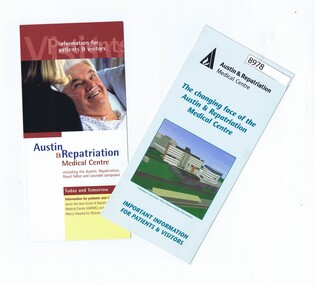
Pamphlet - Pamphlets, Austin & Repatriation Medical Centre 2001, July 2001
2 Pamphlets with information about the Austin & Repatriation Medical Centre and the Mercy Hospital for Women redevelopment in 2001.2 Colour pamphlets with text and photos, map.austin hospital, mercy hospital for women, heidelberg repatriation hospital, austin & repatriation medical centre -
 Greensborough Historical Society
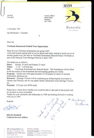
Letter - Correspondence, Banyule City Council, Viewbank Homestead Guided Tour Opportunity, 1998, 15/12/1998
Invitation from Banyule Cultural Services Officer to Jan Macdonald to participate in a guided tour and archaeological dig at Viewbank Homestead January, February and April 1999Comprises letter, with unbound information pamphlet and mapviewbank homestead, archaeological digs -
 Greensborough Historical Society
Newsletter, Greenhills and North Greensborough Progress Association, Community News: official journal of the Greenhills and Nth. Greensborough Progress Association and the Apollo Parkways Progress Association. July 1978. Edition No. 6/78, 07/1978
Orchids can still be found!, Yandell Bushland Reserve: a management study, School news, This and that, Did you know?, From the Council Chamber, A quarry in Plenty???, The restoration of access from Pinehills to Greensborough,Newsletter, 16 p., illus., map.greenhills and north greensborough progress association, greenhills, apollo parkways progress association, apollo parkways -
 Greensborough Historical Society
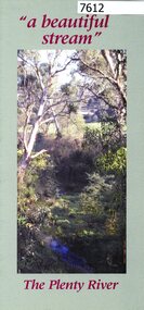
Pamphlet, Friends of the Plenty River, "a beautiful stream": The Plenty River, 2004_04
A publicity pamphlet for "Friends of the Plenty River", a group formed in 1995 to help rehabilitate the Plenty River and adjacent land.2 p., illus., map. Tri-fold pamphlet.plenty river, lower plenty, friends of the plenty river -
 Greensborough Historical Society
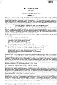
Article, Gary Vines, Mills of the Plenty River, by Gary Vines, 2017_10
Transcript of conference paper on flour mills on the Plenty River, including Arthur Sergeantson's Carome Mill, George Coulstock's Janefield Mill and Moses Thomas's Mayfield Mill. The paper was presented at the 19th Australasian Engineering Heritage Conference in Mildura, October 2017Transcript of conference paper, 26 pages, illus. (some col.), maps.plenty river, flour mills -
![Map - Maps, [John Batman in Melbourne], 1976](/media/collectors/4f729f5697f83e03086015b8/items/60965f673c71fad916b3a651/item-media/60965fc33c71fad916b3a805/item-fit-380x285.jpg) Greensborough Historical Society
Greensborough Historical SocietyMap - Maps, [John Batman in Melbourne], 1976
Photocopies of 4 maps showing aspects of John Batman's time in Melbourne: Map of the settlement of the Yarra 1837; Batman's map of Port Phillip and his route of exploration, 1835, drawn by Wedge; Proposed route of Batman's initial exploratiion, and Enlargement of the Geelong region of Batman's map. No citations on any copy.Photocopy of maps, 4 pages.john batman, melbourne, port phillip -
 Greensborough Historical Society
Document, Parliament of Victoria, Ministers & Members search - the Hon. Colin Brooks (Bundoora), 23/04/2021
Biographical details of the Hon. Colin Brooks, MLA for Bundoora, taken from Parliament of Victoria - Ministers and Members website; and, map of the electoral district of Bundoora.2 p. text and colour photograph, with colour map of Bundoora Electoral Districtbrooks family, victoria parliament, colin brooks, bundoora -
 Greensborough Historical Society
Booklet, Parks Victoria et al, Plenty Gorge Park fire recovery, 15/04/2020
Community update on rehabilitation of the section of Plenty Gorge Park affected by a bushfire in December 20196 p. text and colour photographs and mapplenty gorge park, bushfires, blue lake, yellow gum park, plenty -
 Greensborough Historical Society
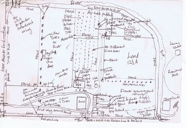
Map, Gary Partington, Alwyn at Whatmough Park, 1960s
The property "Alwyn" was owned by the Partington family and was compulsorily acquired by the Shire of Diamond Valley to become Whatmough Park. This plan was drawn from memory by Gary Partington and illustrates land use when his father, Alan Partington, owned the property.This plan illustrates the rural nature of land around Greensborough prior to the 1960s.Drawing of land use in 1960s at "Alwyn", a property currently occupied by Whatmough Park alwyn, partington family, whatmough park -
 Greensborough Historical Society
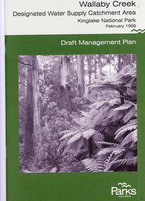
Booklet, Parks Victoria, Wallaby Creek: designated water supply catchment area. Kinglake National Park: Draft management plan 1998, 1998_02
Wallaby Creek is part of Kinglake National Park, and is a restricted access catchment area to protect quality of water supplied to Melbourne's water supply system. 26 p. black print on white paper, green cover, three folded mapskingllake national park, water supply, wallaby creek, parks victoria -
 Greensborough Historical Society
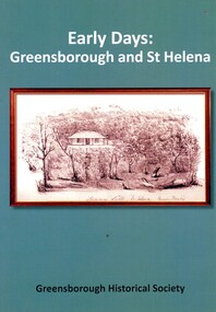
Book, Peter Van Eeken, Early days: Greensborough and St Helena, 2021
History of the Greensborough and St Helena areas 1837-1900GHS produced publication113 p. black print on white paper, illus., maps.st helena, greensborough, greensborough historical society -
 Greensborough Historical Society
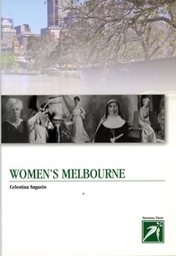
Book, Celestina Sagazio, Women's Melbourne by Celestina Sagazio, 2010
This book contains maps and walking tours of Melbourne with a focus on places that are important to the development of women's rights over the years.96 p., paperback, illus. (some col.), maps.melbourne, women, women's rights, walking tours -
 Greensborough Historical Society
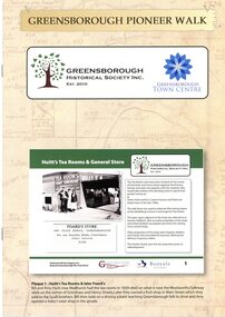
Booklet, Greensborough Historical Society Inc, Greensborough Pioneer Walk, 2021
A guide to the historic photographs which have been mounted on 12 plaques in Greensborough Town Centre. 8 p., photographs, captions and mapgreensborough, pioneer walks, greensborough historical society -
 Greensborough Historical Society
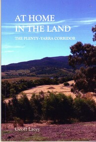
Book, Geoff Lacey, At home in the land: the Plenty-Yarra corridor, 2021
111 p., paperback, col. photographs, mapsnon-fictionindigenous plants, indigenous fauna, plenty river, yarra river -
 Greensborough Historical Society
Map - Map (Copy), C. Hodgkinson, District Surveyor et al, Parish of Yan Yean 1856: Village site during construction of the Yan Yean Reservoir, 1978
Copy of map part Sec. 13, Parish of Yan Yean 1856, Map 3, Village site... Scale: 8 chains to 1 inch. Drawn by C. Hodgkinson, District Surveyor, redrawn by A. R. Blair 1978. 1 p. photocopy of map. yan yean reservoir, yan yean -
 Greensborough Historical Society
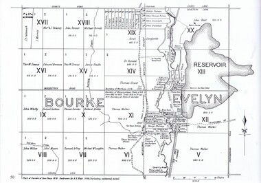
Map, Dianne Edwards, Part of Parish of Yan Yean 1878, 1978
Map includes Crown Portions V - XVII, showing Yan Yean Reservoir, Melbourne-Whittlesea Railway route, names of landowners, roads and various other features west of Greensborough Road. Redrawn by A. R. Blair in 1978.1 p. black and white photocopy of mapyan yean reservoir, yan yean -
 Greensborough Historical Society
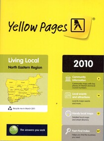
Book - Directory, Telstra Corporation Limited, Yellow Pages: Living local North Eastern Region 2010, 2010
Yellow Pages is a listing of businesses and organisations and their telephone numbers and addresses within the north eastern region of Melbourne432 p black print on white and yellow paper, paperback, includes UBD Street maps and street indextelephone directories, north east melbourne -
 Greensborough Historical Society
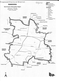
Map - Map (Copy), Electoral Boundaries Commission, Proposed electoral district: Bundoora, 01/07/2021
Proposed revised electoral boundaries for the electoral district of Bundoora (North-Eastern Metropolitan Region) as at 01/07/20211p. black and white copy of mapelectoral boundaries, bundoora - maps, victoria - parliament -
 Greensborough Historical Society
Business Card, Clements Avenue Automotive, Clements Avenue Automotive, Bundoora, 2018c
Clements Avenue Automotive is an automobile repair and service business in BundooraBusiness card, printed in colour both sidesLocation map, contact detailsautomotive repairs, bundoora, clements avenue bundoora -
 Montmorency–Eltham RSL Sub Branch
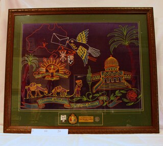
Souvenir - Framed World War 2 Embroidered Banner, WW2 Embroidered Souvenir, Estimated date 1941
Framed embroidered banner – a souvenir of World War Two. A multi-coloured map of Australia, a bird carrying a letter, an Australian military badge, camels and a mosque are depicted on a dark blue background. At the bottom there is a photo, a 1939 associate badge, a dog tag and a brass plaque. 'In Honour of Corp Benjamin Ackroyd VX 5001. Souvenir of Palestine, The Mosque of Omar 1941.'world war two, embroidery, 1941, souvenir, palestine, mosque, omar -
 Montmorency–Eltham RSL Sub Branch
Map - Framed Japanese Map of Darwin Circa 1942, WW2 Japanese Map of Darwin, Estimated date 1940-41
Returned to Australia, from America, where it had been brought back from Japan.Framed map of Darwin with Japanese overprint.'This map is a proof copy of a Japanese Reprint of an Australian map of Darwin.'darwin, world war two, japan, australia, 1942, 1941, maps -
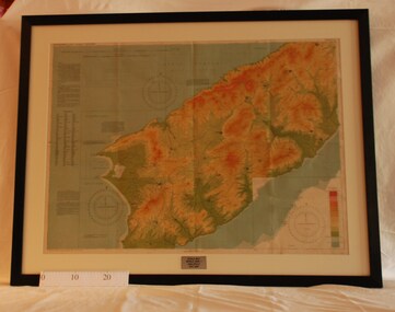
 Montmorency–Eltham RSL Sub Branch
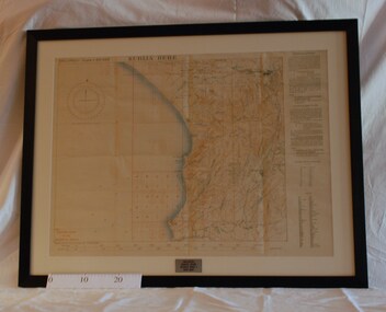
Map - Framed 1915 Anzac Cove Map, Gallipoli, 1915.ANZAC Cove Map, 1915
A framed map depicting trench lines and the battlefields of the Gallipoli Campaign, 1915, made by the Survey Department Egypt. Depth soundings of landing areas off Anzac Cove.Gallipoli - Anzac Cove World War One Map - 1915world war one, anzac, gallipoli, 1915, anzac cove, map, dardenelles, trench lines, depth soundings, landing areas -
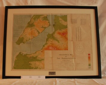 Montmorency–Eltham RSL Sub Branch
Map - Framed 1915 Map of Krithia, Gallipoli, 1915 Map of Krithia, Gallipolli, 1915
A framed topographical map of The Dardenelles produced from captured Turkish maps by the Egyptian Survey Department. The main feature is the Krithia battlefield area in 1915.Krithia Peninsula (The Dardenelles) World War One - 1915 Mapworld war one, 1915, egypt, map, dardenelles, krithia, survey department, turkey, battlefields -
 Montmorency–Eltham RSL Sub Branch
Map - Framed 1915 map of Sulva Bay, Gallipoli, 1915 Map of Silva Bay, Gallipoli, 1915
... View Road Montmorency melbourne This map was used ...This map was used in the Dardenelles Campaign 1915-1916.Framed map showing the Sulva Bay area of the Gallipoli battlefield in 1915.world war one, middle east, gallipoli, 1915, map, dardenelles, sulva bay, survey department, battlefields, egypt cairo -
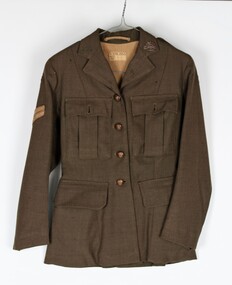 Montmorency–Eltham RSL Sub Branch
Uniform - Jacket, Khaki, Service Dress WW2 (Womens), 1943
Dress jacket worn by Corporal Kathleen Phyllis Gill from Toorak Hill, Casterton. Army No. VF345716 Unit LHQ (Mil. Sec)Lined women's khaki dress jacket. Long sleeved. Wool polyester. Four metal buttons down the front with the inscription Australian Military Forces with a map of Australia in the center with a crown at the top of the map. Two hip pockets on the left and right with a flap on each. Two pleated pockets over the left and right breasts with flaps and small metal buttons inscribed Australian Military Forces with a map of Australia in the center with a crown at the top of the map. Australian Military Forces badge on the upper left lapel Two epaulets on the left and right shoulders with two small buttons inscribed Australian Military Forces with a map of Australia in the center with a crown at the top of the map. AWAS (Australian Women's Army Service) badges at the base of each epaulet. Corporal's stripes 6 cm down the right sleeve. Unit patch red over black - LHQ (Mill Sec). Two vertical belt loops at the back on the left and right. Pleat opening at the back. Horizontal strip of material inside the collar at the back of the neck to hang jacket. Tag sewn onto the lining at the back 2.5 cm down from the top stating - V 579 Made in Australia D. broad arrow D. 1943 Size kathleen gill, wool polyester, women's dress jacket -
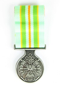 Montmorency–Eltham RSL Sub Branch
Medal - Military Kid Medallion, Foxhole Medals, After 2004
This medal was presented to the children of Victorian Wing - Warrant Officer and Non Commissioned Officers Academy Soldier who have served on operational deployments. As these young children endured an operational deployment of a parent who spent many months away from home in a foreign country representing the Australian Army. Following operations include Bougainville, East Timor, Indian Ocean, Solomon Islands, Meddle East Area, Afghanistan and Sinai.Presented by the Government to children whose parents had served overseas Silver medal with pale green, yellow, orange and deeper green ribbon. It has a metal type container with a clear plastic front and also a black carry bag with Military Kid and print of medal on front. The design is based on the Australian Tri Service Logo. More detailed information can be found on Military Kids websiteOn reverse: "For perseverance on the home front during your parents deployment"; map of Australia (haut relief)military kid, military medal, kids medal -
 Montmorency–Eltham RSL Sub Branch
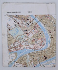
Map, Baghdad
Prepared and published by the National Imagery and Mapping Agency Copyright 2003 by the United States GovernmentPaper, coloured The map is of Baghdad Iraq city Graphic 1:25,000. WGS 84 Edition 11- NIMA Series K941 Sheet 4 Map information as of 2001map -
 Montmorency–Eltham RSL Sub Branch
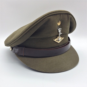
Cap, Peaked, Royal Australian Signals, 1988, 1988
Standard issue peaked cap for 1988.Peaked khaki cloth cap with brown 18mm leather chin strap with two 13mm AMF gilt buttons (crown and map only). Khaki cloth covered peak. Royal Aust. Signals cap badge. Brown leather sweat band. Plastic covered, grey cloth liner with black stamped manufacturer's, etc. details. Australian Government Clothing Factory and logo Size /|\ 56 VIC 1988 (Note - no personal markings) headgear, cap -
Lorne Historical Society
Print - Framed coloured print, Print Accommodation Lorne to 1950
Rob Coy depicted the 22 following buildings with a map 1. Bonnie Doon 2. Gracedale 3. Cora Lynn 4. Carinya 5. Kia-Ora 6. Kalimna 7. Argyll 8. Minapre 9. Erskine House 10.Hotel Pacific 11. The Cumberland 12. Riverview 13. Hotel Lorne 14. The Chalet 15. Santoy 16. Clovelly 17. Yendallock 18. Nenthorne 19. Quamby 20. Ben-My-Kree 21. Glenora 22. Ozone House Rectangular framed color print of Rob Coy ‘ sketch Accommodation Lorne to 1950. The guest houses were, Bonnie Doon, Gracedale, Cora Lyn, Karinya, Kia Ora, Kalimna, Argyle, Minapre, Erskine House, Hotel Pacific, Cumberland, Riverview, Lorne Hotel, Chalet, Santoy, Clovelly, Yendaloch, Nenthorne, Quamby, Ben - My Cree, Glendora, Ozone House and a small map showing the locations of the accommodation. We believe this this is the original print. The colors are mainly blue and light tan. rob coy, lorne, accommodation, hotels, guest houses, pubs, erskine house