Showing 594 items matching " underground"
-
 Kiewa Valley Historical Society
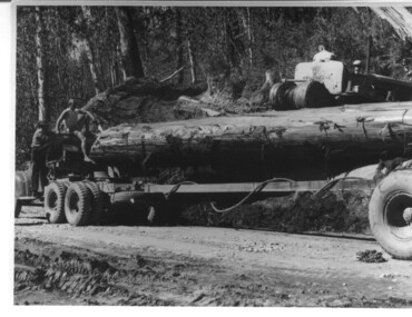
Photograph, logging at McKay Creek, Logging at McKay Creek, 1949/50
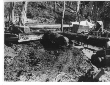
This photo was most likely taken at the site of the proposed McKay Creek Power Station. Excavation of this site was commenced in 1951 but an access road (a rough, narrow track) was put it in 1948 and widened in 1954. The State Electricity Commission would have milled logs from this area at their mill at Howman's Gap. The timber was used for building of housing and camps and provided a much needed resource as there was a general shortage of this commodity. The power station was relocated underground owing to repeated problems with landslides in the area. Restricted financial resources and the repositioning of the power station retarded construction activities and it was not completed until early 1961. An historical pictorial record of the type of machinery used in the 1950's - logging truck with bogie attached, the bull dozer and winch for hauling logs to the truck and note the lack of protective clothing!Black and white photograph showing a logging truck, bogie and bull dozer with winch for hauling the logs to the truck. Two men are on the truck, a driver on the bull dozer and a large log on the bogie. Hand written on the back of photo "Logging at McKay Creek".logging, mckay creek, timber, machinery -
 Otway Districts Historical Society
Book, Government Printer, Potato diseases in Australia, 1911
Potatoes are known for their great liability to disease, suffering more from the ravages of fungi than any other crop, and this is largely owing to the fact that they are propagated from tubers which are just swollen portions of underground branches of the stem. Portions of the parent plant in the form of tubers or cuttings are planted year after year, so that any inherent weakness in the original is transmitted to the offspring, and therefore, without a process of selection, deterioration is sure to occur sooner or later. When the tubers are raised from seed and a good selection made from them, they are less liable to disease at least for a number of years. Handbook of fungus diseases of the potato in Australia and their treatment. D. McAlpine. 1st ed. Department of Agriculture, Victoria; Melbourne (Vic); 1911. x, 314 p.; illus., map. Hard cover.potatoes; disease; fungus; agriculture; -
 Melbourne Tram Museum
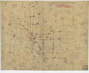
Drawing, Melbourne & Metropolitan Tramways Board (MMTB), "Route Map showing location of special work and pole numbers" "substations", late 1942
Map of the system shown at two inches = 1 mile. Drawing No. P5799. Shows crossovers, track layouts at junctions, signal cabins roads, railways, and stations. Originally signed by Perway Engineer - 20/12/1940, though originally drawn in 1922. The plan shows the lines to Maribyrnong Munitions works along Cordite Ave and Wests Road and the track from Moonee Ponds to Union Road, opened in July 1941, and the extension to Essendon Airport built in 1942, but not the Queen St North Essendon substation. Shows underground cables, tram and bus depot, workshop locations, and substation locations and their priority.Yields information about the MMTB substation locations in 1942.Drawing - dyeline cloth backed print - titled - "Route Map showing location of special work and pole numbers" and subtitled - "Substations". trams, tramways, mmtb, trackwork, tramways, junction, map, world war 2, substation -
 Melbourne Tram Museum
Document - Report, Melbourne & Metropolitan Tramways Board (MMTB), "Chairman's Overseas Visit", 1962
Copy of a report, 3 A5 sheets and 1 A5 cut sheet, stapled, titled "Chairman's Overseas Visit", discussing overseas developments following an overseas tour and the development of underground tramway systems in the CBD, including the closure of the Collin St tram lines in favour of Bourke St. Looks at congestion, development of the City Loop, monorails, motorists, Spencer St Station. See also Reg Item 409 and 2812 for further references. Item 409.4 referees to the Chairman's Tour of 1962.trams, tramways, mmtb, collins st, bourke st, swanston st, underground tramways, reports -
 Melbourne Tram Museum
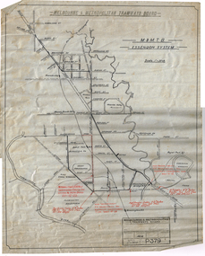
Drawing, H. S McComb, "M&MTB Essendon System", 1922
Drawing - ink of linen, titled "M&MTB Essendon System", showing the Essendon Tram lines and loops with High Voltage and underground power cables shown in red ink with a reference note to the relevant SEC document. Does not show Puckle St. Drawing No. P379dated 2-8-22 Note: This item is part of the H. S. McComb papers - was located in box 8 rolled up. Relocated to a flat file at the time of cataloguing. Number in the McComb collection series.trams, tramways, tramways, mmtb, drawings, essendon, maribyrnong, keilor rd, racecourse rd, victoria st, flemington bridge, secv -
 Melbourne Tram Museum
Document - Report, Melbourne & Metropolitan Tramways Board (MMTB), "MMTB Planning Branch - Maximum Capacity of a Double Track Tramway", Jun. 1968
Report - 9 foolscap sheets - titled "MMTB Planning Branch - Maximum Capacity of a Double Track Tramway", dated June 1968 looking at the capacity of Swanston St in peak hours compared to an underground tramway with bogie or articulated trams. Compares different types of trams - SW6 to PCC, headways, time intervals, size of tram stops, traffic lights and comments. 2nd copy - original document - card covers, red binding on the left hand side - with three diagrams,2nd copy has "Lees" in top right corner.trams, tramways, mmtb, tram stops, swanston st, tramcar design, tramcar operations, traffic lights -
 Bendigo Historical Society Inc.
Document - THE SEA GOLD MINING AMALGAMATED COMPANY N. L. - NOTES ON THE SEA GOLD MINING
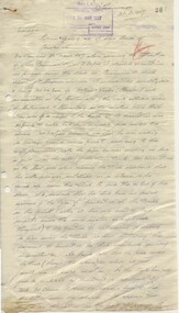
Carbon copy of notes, with typed copy of same, on The Sea Gold Mining Amalgamated Company N. L. on the Garden Gully Line of Reef. Notes include size of lease, office, locality of shaft, sill and depth of shaft, plant, first & last crushing, Prominence, call and dividends, gold yield, best gold and underground connections. Signed by A Richards. Written at the top of page: Original to Mr R Leach, Manager, Allan's Music . Notes prepared by Albert Richardson.document, gold, the sea gold mining amal coy n l, the sea gold mining amalgamated company n. l., notes on the sea gold mining amalgamated company n. l., mccoll & rankin, mines dept plan 1937, annals of bendigo mining sections, g brown bendigo goldfield 1936, wood & mcnair s'brokers 1912, v pabst bendigo goldfields central area 1917, mines dept records, a richardson -
 Bendigo Historical Society Inc.
Document - LONG GULLY HISTORY GROUP COLLECTION: INCURSION 1/11/1935 TO -/5/1936
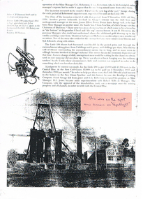
BHS CollectionPhotocopy of a page with photo of the Little 180 Gold Mine N. L. and a C. P. Diamond Drill used in underground prospecting. Article mentions an incursion which took place between 1/11/1935 to -/5/1936 between the Little 180 and Central Blue. It mentions the people involved and the Court judgement that was made. Written on the back is - this was sitting where Spotlight is now.. Junction of Marong Eaglehawk Rd. A pink sticker on the photo has written on it - this was on the spot now known as Spotlight.bendigo, history, long gully history group, the long gully history group - incursion 1/11/1935 to -/5/1936, e g robertson, savage, little 180, james elliot potter, south new chum syncline, h thompson, lou moroni, syd edwards, central blue, new chum syncline, bendigo crushing company, frank savage, h e jones, robert wills, spotlight, m thomson -
 Ballarat Tramway Museum
document - Correspondence, State Electricity Commission of Victoria (SECV), "Opening up of tram tracks by Plumber etc", Mar. 1937
Yields information about the correspondence between the SEC staff about the opening of tram tracks for underground services.Original of a report, handwritten in pencil from a copy book (pages 26 and 27), dated 23/3/1937, addressed to the Manager, from Mr. Mawby titled "Opening up of tram tracks by Plumber etc" reporting on a Mr. McLean excavating under track in Drummond St on 23/3 for a Ballarat Water Board pipe and the issues that arose. No notification to the SEC, underground services, and the absence of advice from traffic crews. Gas company also mentioned in the letter.Various initials and notes in red pencil or ink.tram, trams, letters, sec, tram track -
 Bendigo Historical Society Inc.
Map - HUSTLER'S REEF MINE - TRANSVERSE SECTION OF THE HUSTLER'S REEF MINE
Transverse Section of the Hustler's Reef Mine on the Hustler's Line of Reefs. Bulletin No 33, Plate No XVIII. Shows cross-cuts and their depth, different types of stone and geological features encountered. Drawing of poppet legs at the surface and Sill of Shaft 756.39 ft above Sea Level. Reference Table shows key to the different stone and geographical features encountered. Geographical Survey of Victoria. Signed by H A Whitelaw, Underground Survey Office, Bendigo, September 1913. Thompson's Reef is also mentioned on the map. mining, hustler's reef mine, transverse section of the hustler's reef mine, geological survey of victoria, h a whitelaw, underground survey office bendigo, thompson's reef. -
 Bendigo Historical Society Inc.
Newspaper - Sir John Quick Museum, Michele Matthews Collection, 17.10.1998
The Sir John Quick Committee was formed in 1991 to commemorate the achievements of Sir John Quick who played a prominent role in the federation of Australia. The Committee aimed to raise awareness of the contribution of Sir John Quick and to ensure that he was recognized for the part he played.Two newspaper articles published in the Bendigo Advertiser 17.10.1998. a. Front page story announcing that construction of the Sir John Quick Bendigo Museum was about to begin after the city received a grant of $1.25 million from the Federal Government's Federation Fund. The project was in the concept stage and was to be constructed in rooms adjacent to the Visitor Centre and in the underground area of the Post Office building. b. Newspaper article "Man of History" written by Alistair Paton, describing the contribution of sir John Quick to the federation of Australia.sir john quick, sir john quick museum, museum, federation -
 Bendigo Historical Society Inc.
Map - HUSTLER'S REEF & HUSTLER'S REEF NO 1 MINES - LONGITUDINAL SECTION OF THE HUSTLER'S REEF & HUSTLER'S
Longitudinal Section of the Hustler's Reef & Hustler's Reef No 1 Mines on the Hustler's Line of Reef. Bulletin No 33, Plate No XX. Note - Plates 4, 8, 13, 20, 26 & 31 form a Longitudinal Section from Fortuna Hustler's to Hustler's Consols Mine. Geological Survey of Victoria emblem. Signed by H A Whitelaw, Underground Survey Office Bendigo, September 1913. Shows the two shafts with their levels and depths. Also shows geographical features and yields of gold and amalgam per ton. .mining, parish map, hustler's reef & hustler's reef no 1 mines, geographical survey of victoria, underground survey office bendigo, h a whitelaw -
 Bendigo Historical Society Inc.
Map - FORTUNA HUSTLER'S MINE - PLAN OF FORTUNA HUSTLER'S MINE
Map and plan of the Fortuna Hustler's Mine on the Hustler's Line of Reefs. Bulletin No 33, Plate No 1. Plan gives depth of the different levels. Bendigo Railway Station is on the map and also a number of the streets. Carpenter Street is called Cemetery Road. Also on the Hustler's Line of Reef is the Summer Hill Shaft. Shown is the Hustler's Royal Reserve No 2 Lease. Map has the Geological Survey of Victoria crest. It is signed by H Whit ? an Underground Survey Office Bendigo, September 1913. map, fortuna hustler's mine, hustler's royal reserve no 2 lease, summer hill shaft, hustler's line of reef -
 Bendigo Historical Society Inc.
Document - MINING REPORTS - REGULATION OF MINES STATUTE 1873
Handwritten extract from the Bendigo Advertiser 3/1/1874. Regulation in force from 1st January 1874. Regulation states the minimum age of boys working at the mines, no female of any age can be employed underground, the maximum hours under 18's worked, no person under 18 to be in charge of any steam engine, boiler or mechanical power and no person in charge of steam machinery to be employed more than eight hours in any one day as an ordinary day's work.document, gold, mining reports, regulation of mines statute 1873, bendigo advertiser 3/1/1874 -
 Bendigo Historical Society Inc.
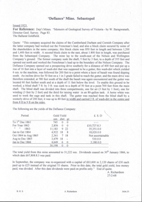
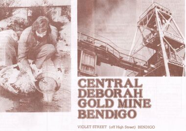
Book - JOAN O'SHEA COLLECTION: CENTRAL DEBORAH UNDERGOUND PROJECT, 20th June, 1986
Joan O'Shea Collection. Central Deborah Gold Mine Bendigo Violet Street (off High Street) Bendigo Pamphlet. Buff and Sepia double-sided A4. The Bendigo Trust in conjunction with the City Family Hotel present the opening of the Central Deborah Gold Mine Underground Project, by Premier John Cain, 20th June, 1986 featuring the City Club Dancers. Includes a brief chronological history of the mine and photographs courtesy of Phillip Beer on recto side. The verso side contains a map of the site of the Central Deborah Gold Mine and also various photographs with further detail of areas of interest including: poppet legs and shaft, the change rooms, caretakers or rag pickers room where clothing was searched, the drying room, the first aid room, carbide light room, underground tours, carpenters shed, ore bins and loading bays, stamper battery, wilfley table, berdan plans, laboratory, display room, boiler, stoke hold, winding engine, boiler feed pump, electric driven compressor, steam driven compressor and the blacksmith's shop.Central Deborah Gold Mine Bendigobendigo, gold mining, central deborah gold mine -
 Kiewa Valley Historical Society
Photograph, logging at McKay Creek, Logging at McKay Creek, c1950's
This photograph was probably taken at the site of McKay Creek Power Station. Excavation of this site did not commence until 1951 but road access(a narrow track) was provided in 1948 and widened in 1954. The logs would have been milled for timber at the State Electricity Commission's mill at Howman's Gap and thus provided a much needed source of timber for construction of camps and houses as there was a general of shortage of this commodity. Because of trouble with landslides in this area, a decision was made to place the machine hall of the power station underground instead of on the surface. Restricted financial resources and the repositioning of the power station retarded construction activities and it was not completed until early 1961.. An excellent pictorial record of the general working conditions, type of machinery and vehicles in use in the 1950/s.Black and white photograph showing logging equipment, fallen logs.Handwritten on the back of the photograph "Logging at McKay Creek)logging, mckay creek, timber, machinery -
 Bendigo Historical Society Inc.
Ephemera - WARNE COLLECTION: GILLIES PAPER BAG
Paper bag advertising Gillies famous pies. Under the Gillies logo of a boy eating a pie a list of places where to buy including: Bendigo, Kangaroo Flat, Geelong, Ballarat, Wendouree and Thomastown. Under in red ''If it's Gillies it's Good''. Donuts, cakes, pastries, yeast goods. On the back: Central Deborah Gold Mine, go 200 feet underground, Enjoy the challenge, see the gold in the quartz, learn how the miners worked, explore the surface displays. Proudly sponsored by Gillies Brosbusiness, retail, gillies -
 Bendigo Historical Society Inc.
Document - JOAN O'SHEA COLLECTION: CENTRAL DEBORAH GOLD MINE BENDIGO, 26th November, 1984
Joan O'Shea Collection. Central Deborah Gold Mine Bendigo. Promotional material. Chronological History, Poppet legs and shaft, Change Room, Caretakers or rag pickers room, Drying room, first aid room, carbide light room, Underground, carpenters shed, ore bins and loading bays, stamper battery, wilfley table, berdan pans, laboratory, display room, boiler, stroke hold, winding engine, boiler feed pump, electric driven compressor, steam driven compressor, blacksmith's shop.Photograph Courtesy Philip Beer.mining, marketing, central deborah mine. -
Bendigo Historical Society Inc.
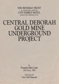
Document - Central Deborah Gold Mine Underground Project Opening, 1986
Parry CollectionCentral Deborah Gold Mine Underground Project Opening by Premier John Cain, featuring the City Club Dancers. The program is produced by the Bendigo Trust in conjunction with the City Family Hotel. Program: 1. Acknowledgements of sponsors. 2. The legend of Lady Deborah 3. Awakening of Deborah by the Victorian Police Band 4. Short history of the mine Also included is a gold embossed invitation and its envelope, to Mr and Mrs J. Parry from the Chairman of the Bendigo Trust Mr D. H. R. McLure and Directors.history, bendigo, j s parry collection, central deborah mine opening -
 Bendigo Historical Society Inc.
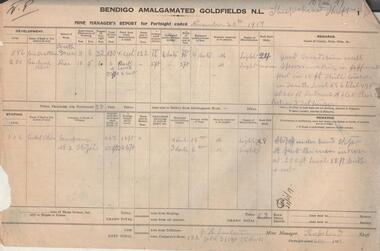
Administrative record - Bendigo Amalgamated Goldfields N.L. Mine Manager's Reports, 1917 - 1920
In 1917 Bendigo Amalgamated Goldfield Ltd was formed from the amalgamation of 35 companies with operations on the Garden Gully, Sheepshead, Deborah and Derby lines of reef hoping to increase profits of these existing operations through economies of scale. This was difficult to achieve as the shafts involved were spread throughout the goldfield. Diamond drilling and good geological practices were introduced (Pabst was Chief Geologist) leading to some exploration success. However costs were rising rapidly and in 1923 the directors, deciding that mining would soon become unprofitable, dissolved the company returning assets to the original vendors. J.H. Lenten, Mine Manager, received his second class Mine Manager's certificate in September, 1914 at an examination held at the Bendigo Law Courts. One hundred pages of fortnightly manager's reports for Bendigo Amalgamated Goldfields N.L., Sheepshead Shaft. Reports consist of two pages for each fortnight, signed by J.H. Lenten, Mine Manager. Dates of reports range from November 20th, 1917 to 5th May 1920. Categories reported on include: development, stoping, tons from tributors, tons Company's stone, plant and machinery, underground workings, number of rock drill shifts, firewood used, coal burnt, and general remarks. charcoal burnt., lifting waterbendigo, margaret roberts, , goldmining, bendigo amalgamated goldfields, sheepshead shaft, j.h. lenten, mine manager -
 Melbourne Tram Museum
Document - Report, Melbourne & Metropolitan Tramways Board (MMTB), 'Current trends which may indicate the future growth and nature of the metropolitan area and in particular the Central Business area of Melbourne", Jan. 1966
Report - Foolscap, card covers, red binding strip, about pages + drawings or charts, titled 'Current trends which may indicate the future growth and nature of the metropolitan area and in particular the Central Business area of Melbourne" Has three parts: 1 - Future growth of population of the Melbourne Metropolitan Area 2 - The Centre of Gravity of and general distribution of the Central Business area of Melbourne 3 - Future growth of the Central Business Area of Melbourne. Dated Jan 1966, prior to the construction of the Underground Railway and the move to Docklands.Has "JEC" in pencil on top right hand corner.trams, tramways, melbourne, planning, development -
 Bendigo Historical Society Inc.
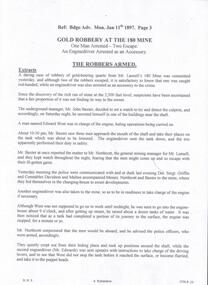
Document - LANSELL'S BIG 180 MINE - ROBBERY AT THE 180 MINE
Handwritten notes and typed copy of same, on a gold robbery at the 180 Mine. One man was arrested and two escaped. The engine driver was also arrested as an accessory to the crime. The underground manager, Mr John Baxter decided to set a watch and the men were caught red-handed. The Det-Sgt was reduced in rank and transferred to Melbourne. He knew the men would be coming up at a certain time. He didn't have sufficient police to surround the mine and he did not take any lanterns. Albert Richardson Collection. document, gold, lansell's big 180 mine, lansell's big 180 mine, robbery at the 180 mine, bendigo advertiser mon jan 11th 1897 page 3, mr lansell, john baxter, edward west, mr northcott, det-sgt griffin, const. davidson, const. mallon, mr edwards, mr grenfell, long gully fire brigade, victoria quartz mine, bendigo advertiser tues jan 12th 1897, mr thomas, bendigo advertiser mon jan 18th 1897 page 3, alfred rogers, mr pellow, james trahair, bendigo advertiser fri jan 22nd 1897, bendigo advertiser fri feb 26th 1897, bendigo advertiser fri april 2nd 1897 -
 Bendigo Historical Society Inc.
Map - GREAT EXTENDED HUSTLER'S MINE - PLAN OF THE GREAT EXTENDED HUSTLER'S MINE
Plan of the Great Extended Hustler's Mine on the Hustler's Line of Reefs, Bendigo. Bulletin No 33, Plate No X. Lease No 7382. Plan has map of streets. Mine was located in the block bounded by Langston and Anderson Streets and was between the Hustler's Anticline at Surface and the Lightning Hill Anticline at Surface. Latham & Watson's Shaft is also mentioned. Levels are numbered and a table shows the Levels and their Depths. Geological Survey of Victoria. Signed by H A Whitelaw, Underground Survey Office, Bendigo, September 1913. This item has not been scanned or photographed.mining, parish map, great extended hustler's mine, hustler's line of reefs, mining lease no 7382, geological survey of victoria, underground survey office bendigo, h a whitelaw, latham & watson's shaft -
 Bendigo Historical Society Inc.
Map - FORTUNA HUSTLER'S MINE - LONGITUDINAL SECTION OF THE FORTUNA HUSTLER'S MINE
Longitudinal Section of the Fortuna Hustler's Mine on the Hustler's Line of Reef, Bendigo. Bulletin No 33, Plate No IV. Shows poppet legs at the surface level, Datum Line 750 feet above Sea Level, levels and their depths, the amount of gold per ton and some geographical features. Geological Survey of Victoria emblem and signed by H A Whitelaw, Underground Survey Office, Bendigo. Note - Plates 4, 8, 13, 20, 26 & 31 form a Longitudinal Section from Fortuna Hustler's to Hustler's Consols Mine. mining, parish map, fortuna hustler's mine, longitudinal section of the fortuna hustler's mine, geological survey of victoria, h a whitelaw, underground survey office bendigo, hustler's line of reef, hustler's consols mine -
 Bendigo Historical Society Inc.
Map - HUSTLER'S ROYAL RESERVE NO 2 CO - TRANSVERSE SECTION OF THE HUSTLER'S ROYAL RESERVE NO 2 CO
Transverse Section of the Hustler's Royal Reserve No 2 Co Mine on the Hustler's Line of Reef Bendigo, Bulletin No 33, Plate No VII. Section shows the poppet legs and the sill of Shaft at 707.65 ft above sea level, depth of levels, stone encountered and geological features. Geological Survey of Victoria emblem. H. Herman Director, W. Dickson Secretary of Mines and The Hon. J. Drysdale Brown MLC, Minister of Mines. Signed by H S Whitelaw, Underground Survey Office Bendigo, September 1913. mining, parish map, hustler's royal reserve no 2 co, h s whitelaw, undergrou;nd survey office bendigo, geological survey of victoria, h herman, w dickson, the hon. j drysdale brown mlc -
 Melton City Libraries
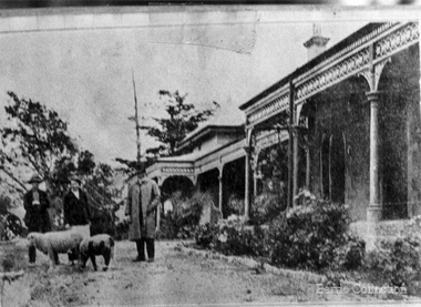
Photograph, Brooklyn Estate, Unknown
Brooklyn Park homestead built 1875 by Stephen George Staughton, son of Simon Staughton. In 1907 the residence was refurbished for Cr Stephen John Staughton who was returning from England with his bride. The building contained over 25 rooms some 25x20 feet. There were elaborately decorated rooms with friezes, embossed wall papers, massive curtains, marble and carved mantle pieces. A Ryder Erickson Hot air engine pumped water from underground tanks up to elevated tanks to circulate water through the house. Acetylene gas generator for 100 light and chandeliers. Prominent family with civic connection in Melton holding very large areas of land. 'Brooklyn' mansion built by Stephen Staughton, local identities, pioneer families -
 Federation University Historical Collection
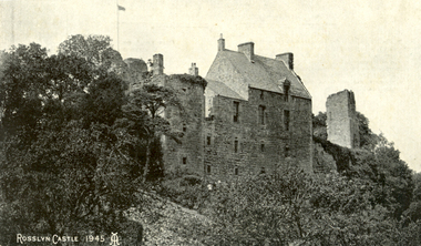
Postcard, Roslin, c1945
Roslin Castle, the seat of the St Clair Family, was founded in 1304. It is partly in ruins. According to legend some millions of pounds worth of treasure being hidden in the vaults. it is said to be under the charge of a lady of the ancient St Clair family. She is to wake from her slumber and point out the spot where the treasure lies. It is located near the village of Roslin in Midlothian, Scotland. It is located around 9 miles south of Edinburgh, on the north bank of the North Esk, only a few hundred metres from the famous Rosslyn Chapel. (See http://en.wikipedia.org/wiki/Roslin_Castle)Three postcards showing different views of Roslin Castle. .1) A stone building on a hill side, with flying flag, .2) The Courtyard, Roslin Castle .3) The Bakehouse, Roslin Castle.1) This a fine view taken from the Glen. Formerly the castle was eight storeys high, five above and three underground. .2) While at Edinburgh I went out to Roslin saw there the Castle and Church. They are both very old dating back 500 hundred years. .3) The hole in the wall is the oven, is an immense thing. A fire was lit in the oven then pulled out and the heat in the stone did the baking.roslin, rosslyn, roslin castle, st clair, spirit, ghost, baking, oven, bread -
 Stawell Historical Society Inc
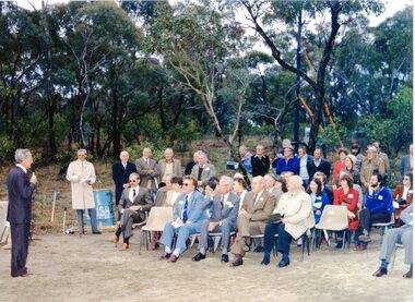
Photograph, Magdala Decline Opening 1981, October 1981
7081, WMC Manager Keith Parry addressing audience, Seated from L. Mine manager Brian Micke, unknown, unknown, Don Webb Seated far right Jean Earle Standing Pat Krause (bearded), John Van Leeuwen (hat and glasses) 7081a: Crowd Scene at the opening of the Magdala decline Front: L to R Eric and Hazel Lewis, Keith and Elwyn Haymes, Joan and Keith Hallam second row: unknown , unknown, Cynthia and Glynn Cashin, unknown , unknown third row: none known fourth row: Peter Ruthven, unknown, Jack Jones, Ken Dadswell at end, behind him Ian McCann Standing behind Mr and Mrs Kinsella on L. 5th from R. Terry Monaghan 7081b: Male Breaking ground with a Gold Pick (Mr David White, Minister for Minerals and Energy) 7081c: Catapillar Dozer digging the decline. 7081d: Conveyor belt moving soil with two workers 7081e: Underground Photo, a worker looking at drill placement. 7081f: The entrance to Magdala Delcine 1981. 7081g: A large dumper in the decline underground. 7081h: A Vehicle at the entrance to the Magdala Decline. 7081i: A Large group of miners around a vehicle at the entrance to the Magdala decline. 7081j: B/W showing a large rock with the dedication Plaque 7081K: Outside machinery for the drive. 7081l: Tanks containing liquid, one with the shell logo, and a red container. 7081m: Yellow tray truck emerging from the Magdala Decline. 14 Photographs showing crowd scenes at the Magdala Deline Opening in 1981 First shows CEO of WMC Keith Parry addressing the crowd Manager Brian Micke seated on far left Mayor Don Webb seated second from right7081k: On Reverse Stawell Gold MInes: Neg 26: 257 7081l: On Reverse Stawell Gold MInes: Neg 24: 257 7081m: On Reverse Stawell Gold Mines: Neg 25: 257 mining -
 Melbourne Tram Museum
Document - Report, Graeme Breydon, "Future Development of Tramways in the Melbourne Central Business District", Apr. 1973
Six paged duplicated paper or report titled "Future Development of Tramways in the Melbourne Central Business District", by Graeme Breydon, presented to the AETA 1973 Convention, based on an article prepared for the August 1972 issue of Electric Traction. Has references, looks at proposals for underground part of the Swanston St tramway, alternatives for flinders St and a Yarra crossing, St Kilda Road issues, William St, CBD problems and travel issues, shortcomings of proposals, alternatives, Flinders Gate interchanges, associated track improvements, cost benefit ratios, comments and conclusions. 2nd copy contains within a brown manila quarto sized folded marked "Tramways in the Melbourne. Central Business District" G. Breydon (Aug. 1972). See also Reg Item 3069 and 2812 for further references. .2 - letter - c Jan 1973 - carbon copy of a Letter to the Editor for response to a letter in Electric Traction Dec. 1972 responding to H. Moses and making specific comments. .3 - letter - 29/1/1973 to Graeme Breydon from the Ian Cooper of the AETA responding and accepting an offer of Graeme to present on the Board's plan for the forthcoming AETA Canberra Conference in April 1972. .4 - Report - 17 Quarto pages, stapled on the left hand side titled "Future Development of Melbourne Tramway System, with particular reference to possible improvements to the fixed plant of the Central Business District", written by Graeme Breydon, dated Jan. 1972. Refers to the 1962 report of Risson, and scheme presented to Council, Has hand drawn maps of the central area of Melbourne, Looks at the background, traffic issues, proposed underground loop, employment distribution, an extension to Elisabeth St, reversing loops, St Kilda Road and comments on the MMTB proposals. Refers to a paper delivered by D Lees, MMTB Planning Engineer, Swanston St underground proposal,on outside of the 2nd copy, and on top right hand corner of paper AETA Library mark "4E11"trams, tramways, mmtb, melbourne, traffic control, swanston st, st kilda rd, elizabeth st, bourke st, aeta, transportation, underground tramways -
 Kiewa Valley Historical Society
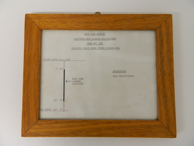
Sketch Rock Core Display, circa mid to late 1900's
This framed sketch details, in graphic form, where the core samples in the display cabinet were removed. The drilling was a precursor to the decision where to locate, in this case, the McKay Creek Power Station. The information gained by structural engineers from the core samples would be used also for the placements of underground tunnels entry and exit points and the overall effective size of the plant. This would have included drill and blast techniques(rock characteristics play an import part of explosion control), requirements for support structures and reinforcing cement/steel forms. The use and replenishment of diamond drill bits(the strongest available, see KVHS 0280) was dependent on the "type" of rock found. Support beams for reinforced ceilings and floors was also a necessity.The visual derails of where the rock core samples were removed is very significant in the formulation and placement of the underground Power Stations and their maze of tunnels(in and out) for a successful implementation of the Hydro Scheme. The amount of pre-planning and scientific studies required for such a large scheme must be undertaken to ensure that a "white elephant" was not the result.This framed and glass front rock core display sketch has type written information of the rock samples displayed in KVHS 0279 (A). It has a softwood stained and glossed frame with a fixed(nailed) back board and a brass fixture for mounting onto a wall.The paper and type are slighted faded (sunlight affected). The sign heading "ROCK CORE SAMPLES RECOVERED FROM DIAMOND DRILLED BORE" underneath this "BORE NO: 883" and below this "LOCATION: McKAY CREEK POWER STATION AREA" to the left a sketch incorporating the ground level point "GROUND LEVEL R.L.3493", and the core depth point "CORE DEPTH 40' 7". In between and representing( in visual form) the core location areain question.alternate energy supplies, alpine feasibility studies temperature, rainfall, sec, kiewa hydro scheme, electricity