Showing 416 items
matching wheatly road
-
 Kew Historical Society Inc
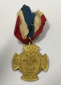
Medal, Stokes & Sons, Town of Kew : To Commemorate its Jubilee, 1910
Medal issued to commemorate the 50th jubilee of the Town of Kew. It names J.F. McCrea as Mayor. John Falding McCrea was Mayor of Kew 1910-11. Kew was proclaimed a municipality on 22 December 1860, seceding from the Boroondara Road Board District, then comprising Kew, Hawthorn and Camberwell. It was proclaimed a town on 8 December 1910, the year this medal was issued, and a city on 10 March 1921. On 22 June 1994 Kew city was united with Camberwell and Hawthorn cities to form Boroondara city.Mint gilt medal with original ribbon.Kew Jubilee medal in the shape of a Maltese cross. Gilded bronze with attached original red, white and blue cloth ribbon. On the front is the Coat of Arms of the Town of Kew and an inscription: ‘Town of Kew. To Commemorate Its Jubilee 1910’. On the reverse is inscribed 'Kew Jubilee 1860-1910. Cr J.F. McCrae J.P. Mayor'. The medal was also issued in bronze.Obverse description Shield of six wheat-sheafs above motto CRESCO on ribbon; above shield is the Royal coat of arms with lion and unicorn supporters and, on ribbon DIEU ET MIN DROIT; on arms of cross top, TOWN / OF, bottom, KEW, left TO COMMEM / -ORATE, right, ITS JUBILEE / 1910 Reverse description Within line circle set at centre of cross shaped flan, CR. J.F. McCREA / J.P. / MAYOR on arms of cross, top, KEW bottom, JUBILEE, left 1860, right, 1910jubilee - kew (vic), commemorative medals - kew (vic), australian commemorative medals -
 Kew Historical Society Inc
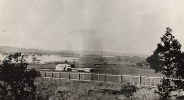
Photograph, Wade's Farm, Kilby Road, Nineteenth Century
""The public trial of reaping machines, under the auspices of the Port Phillip Farmers' Society, advertised to take place on Friday, last, but postponed on account of the weather, came off December 27. The place selected (Mr. Wade's farm, Belford, near Kew) is undulating ground, with a remarkably heavy crop of wheat upon it. This, taken in connection with, the state of the ground, still soft from the recent rains, made the trial an uncommonly severe one. ..."(South Australian Advertiser, 15 January 1859) Some bricks used in Kew buildings came from the brickworks on Wade's Farm at the end of Belford Road near the Yarra River (now part of the Kew Golf Club). (History of RSL by John Torpey)Wade's Farm, Kilby Road, Kew.wade's farm, farming (kew), kilby road, north kew, belford road, kew, kew golf club -
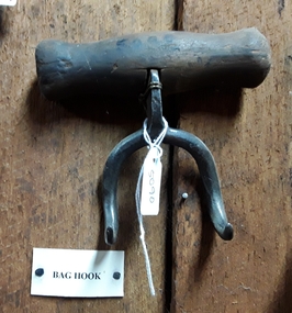
 Friends of Westgarthtown
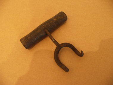
Hook, bag
One of the original bag hooks used on the farm at Ziebell’sHessian bags were used pre 1970 and bag hooks were used to lift heavy bags of wheat, and milled grains such as bran and pollardSmall instrument for hanging and moving bags, bifurcated hook with wood handlerural industry, agriculture, hook, farming, transportation, tool -
 City of Warrnambool Rowing Club
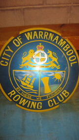
Metal Shield- coat of arms
In 1953 the warrnambool rowing club was given permission to use the warrnambool city council colors and insignia. Circular metal shield with blue and gold enamel paint depicting the rowing clubs shield: A sailing boat, sheaf of wheat and sun below the Coat of Arms of Victoria, the Princess Royal. City of Warrnambool Rowing Club By These We Florishcity of warrnambool rowing club, warrnambool, warrnambool rowing club, warrnambool city council, coat of arms -
 Surrey Hills Historical Society Collection
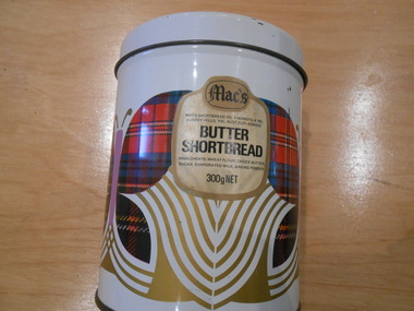
Container - Biscuit tin, Mac's Butter Shortbread tin
Mac's Shortbread Co dates its history back to a family bakery in Abbotsford opened in the 1860's producing bread for the goldfields. This eventually became McAlpine's Flour. This business was sold in 1960 and the family then purchased a cake shop, leading to building a biscuit factory. (This is thought to have been the Surrey Hills site). The company outgrew this and moved to 5 Tate Drive, Kerang. (Further research required.) Australia adopted metric units of measurement in July 1974, so this object was manufactured after 1974.This tin is material evidence of the small area of industrial activities that once existed in Surrey Hills.A cylindrical tin with a silvered interior and the outside finished in a white enamel paint, on which there is a geometric design incorporating a butterfly.On a label incorporated in the design: "Mac's / MAC'S SHORTBREAD CO. 1 NORFOLK RD./ SURREY HILLS, VIC. AUST. 3127 - 8360333 / BUTTER / SHORTBREAD / INGREDIENTS: WHEAT FLOUR, CHOICE BUTTER, / SUGAR, EVAPORATED MILK, BAKING POWDER / 300 g NET"bakeries, surrey hills, mac's shortbread, norfolk road -
 Surrey Hills Historical Society Collection
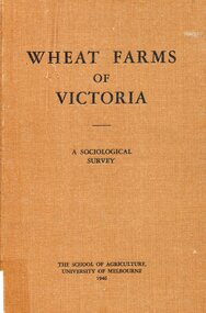
Book, Wheat farms of Victoria: a sociological survey, 1946
The owner, Alan Judge Holt lived locally and was Secretary of the Lands Department. Donated by Max Holt who was one of his sons. This book goes into considerable detail on all facets of wheat farm life, providing the basis for a real understanding of the problems of the man who grows wheat.Cloth-covered hardback book of 179p. Alan J. Holtwheat, social surveys, agriculture, (mr) alan holt, farming -
 Surrey Hills Historical Society Collection
Domestic object - Biscuit tin, Mac's Butter Shortbread tin
Mac's Shortbread Co dates its history back to a family bakery in Abbotsford opened in the 1860's producing bread for the goldfields. This eventually became McAlpine's Flour. This business was sold in 1960 and the family then purchased a cake shop, leading to building a biscuit factory. (This is thought to have been the Surrey Hills site). The company outgrew this and moved to Kerang. (Further research required.)This tin is material evidence of the small area of industrial activities that once existed in Surrey Hills.A cylindrical tin with a silvered interior and the outside finished in a white enamel paint, on which are a pattern with 3 butterflies with tartan wings. there is a small printed paper label1. Mac's / MAC'S SHORTBREAD CO. 1 NORFOLK ROAD, SURREY HILLS, VIC. AUST 3127. 836 0333 BUTTER SHORTBREAD INGREDIENTS WHEAT FLOUR, CHOICE BUTTER, SUGAR< EVAPORATED MILK, BAKING POWDER 300g NETbakeries, surrey hills, mac's shortbread, norfolk road -
Surrey Hills Historical Society Collection
Container - Biscuit tin, Mac's Butter Shortbread tin
Mac's Shortbread Co dates its history back to a family bakery in Abbotsford opened in the 1860's producing bread for the goldfields. This eventually became McAlpine's Flour. This business was sold in 1960 and the family then purchased a cake shop, leading to building a biscuit factory. (This is thought to have been the Surrey Hills site). The company outgrew this and moved to Kerang. (Further research required.)This tin is material evidence of the small area of industrial activities that once existed in Surrey Hills.A cylindrical tin with a silvered interior and the outside finished in a white enamel paint, on which are a pattern of gold lions and tartan structures1. Mac's / BUTTER SHORTBREAD 300g NET./ PRODUCT OF AUSTRALIA MADE BY MAC'S SHORTBREAD CO., 1 NORFOLK ROAD, SURREY HILLS, VICTORA INGREDIENTS WHEAT FLOUR, CHOICE BUTTER, SUGAR, LEAVENING, YOLKINE / Bar code 9 310034 305318bakeries, surrey hills, mac's shortbread, norfolk road -
 Surrey Hills Historical Society Collection
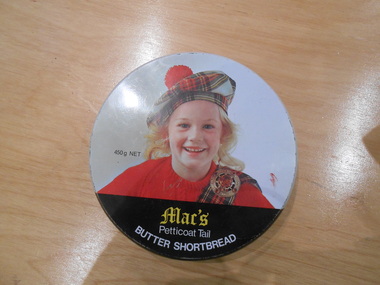
Container - Biscuit tin, Mac's Petticoat Tail Butter Shortbread tin
Mac's Shortbread Co dates its history back to a family bakery in Abbotsford opened in the 1860's producing bread for the goldfields. This eventually became McAlpine's Flour. This business was sold in 1960 and the family then purchased a cake shop, leading to building a biscuit factory. (This is thought to have been the Surrey Hills site). The company outgrew this and moved to Kerang. (Further research required.)This tin is material evidence of the small area of industrial activities that once existed in Surrey Hills.A round tin with a silvered interior and the outside finished in a white enamel paint with the head and shoulders of a blond girl in red jumper, tartan sash and brooch and a tartan tam o'shanter hat.1. Mac's / Petticoat Tail BUTTER SHORTBREAD 450g NET./ BAKED IN AUSTRALIA BY MAC"S SHORTBREAD CO., 1 NORFOLK ROAD, SURREY HILLS, VICTORA AUSTRALIA PHONE 8360333 INGREDIENTS WHEAT FLOUR, CHOICE BUTTER, SUGAR, EVAPORATED MILK BAKING POWDERbakeries, surrey hills, mac's shortbread, norfolk road -
 Melton City Libraries
Map, Streets of Melton, 1963
MELTON’S STREETS Heritage Week 2014 What’s in a Name? Alphabetical List Aboriginal place names, Early Family Names and landowners, Agricultural, Shop and Commercial premises, Places and Events Melton & District Historical Society Street Naming Project 1972 – c 1998 Suburb Name – KURUNJANG - Kirkton, 1972, Brookfield, West, 1988 Melton and Town Centre - A joint collaboration with the Shire of Melton and Subdivision Developers ARNOLD Court – Family house - Arnolds Creek ALKEMADE Drive Family – Lime kilns Coimadia ALEXANDRA Street 1902 – Corination of King Edward VII and Queen Alexandra AVIATOR Place Event, location of plane crash – Jimmy Melrose 1936 Adina ?Annibee - Anniba? Agricultural Avon court .. .. BAKERY Square - Location of Jongebloed shop, bakehouse and stables BALUK Place Aboriginal BARLEYCORN Place Agricultural BILLING Place Name of Jimmy Melrose Uncle Noel Pemberton Billing BLACKWOOD Drive - Alexander Blackwood 1860c Registrar BARRIES Road C. E. Barrie “Darlingsford” farmer 1911, chaff mill owner BROOKLYN Road Staughton family residence. 1875 – Dismantled c 193? CAHILL Drive Family - Glenville Dairy CAMERON Court Family Canopus Place ? CANALLAN Drive Early Surveyor CAMPBELL Court Aviation – Melrose passenger 6th July 1936 CARBERRY Drive Michael, early landowner family CAREW Court Edward and Michael. Royal Hotel. Vera (Carew) Forran Singer - Opera CASEY Court Family CASHIN Court Family CHEVIOT Court Agriculture, breed of sheep CHESNEY Road was re named ( Minns Road being duplicated c 1973) CHRISTINA Crescent Christina McPherson, daughter of James and Mary Mary McPherson. Died 1955 aged 85 years COLLYER Close a deleted street (parallel to Yuille) re-used CORRIEDALE Road Breed of sheep CORR Court Teacher at first school, landowner CROXTON Court Name of the Hornbuckle and Knox family home DALEY Court - William Daley and family 1865 Bootmaker High Street DARLINGSFORD Boulevard - Name of early homestead Thomas B Darling 1853 DJERRIWARRH Court - Parish County of Bourke - very early map. DODEMAIDE Place Early land owners - Melton Football Team had 6 brothers playing c 1924 DONALD Court McPherson family 6 generations in Melton in 1936 DOUGAL Court DUNCAN Court .. .. DUNVEGAN Circuit Home of the McPherson family, castle Isle of Skye Name of bluestone house Smith Street (now at Willows) EMIL Court Jongebloed family EXELL Avenue Farming family Melton Sth- Closer Settlement 1907 EXFORD Road Exe former name of the Werribee river FARMER Court Name of early postmistress FERRIS Road John Ferris Farmer HANNAH Close First name of Hannah Watts – midwife HAYBALE Place Agricultural HELDER Court Early surveyor J Helder Wedge map HEWSON Street Winston Hewson Shire Engineer – check title c 1960 HENRY Street Township map c 1860 HESTON Street Heston Phoenix – C.J. Melrose plane HILDEGARDE Court Jimmy Melrose’s mothers name HOMESTEAD Close HORNBUCKLE Cres Farmers. Three members of family - Shire Presidents HURLEY Street Farmers IAIN Court Descendent of James and Mary McPherson JAMES MELROSE Drive Name appears on 2013 Melton information map JANG Place KURUN – jang KIRKTON Drive Name of the McPherson family home Toolern Vale Road KIRWIN Street Michael early landowners (deleted for freeway construction) KILPATRICKS Road Deleted when Barries Road was extended across Station Rd KOROROIT Court Early map, Parish of Kororoit. Creek name KNOX Circuit Family – Hornbuckle “Croxton Park” KURRUNJANG Drive Aboriginal name for people of the red earth – Suburb name Lara Place ? LLOYD Court Garage owners High Street. Laura lived to 100 years D 1955 LUBY Court John Luby – Crown Grant Land Title LITTLE Court MANNING Avenue Richard, hotel owner 1891 MARGARET Drive McPherson family McDONALD Street Melton South family name McKENZIE Street Township c1860 MORROW Street Early name MOWBRAY Crescent Name of English Melton, popularly believed origin of Melton MYERS Court Early setters c 1866 Crown Grant Land Title NIMMO Street Early name NIXON Street Name submitted by Mary nee Nixon Collins c1985 OLDERSHAW Road Early builder PALMERSTON Street Early township map c 1860 PEART Court Early name PENNYROYAL Avenue Plant growing by the creek. Early name used for the Toolern Toolam Creek PINKERTON Street Family name and early street map PINNACLE Crescent Agricultural - type of wheat PHOENIX Circuit C.J. Melrose Phoenix Heston Plane 2013 map PRATT Family PRIOR Court PYKE Place Brothers – early settlement 1838 RADFORD Court Land owners and business operators. Former Royal Hotel Grocer High Street demolished 1970 RAGLAN Court Hotel 19th century Lord Raglan RALEIGHS Road Oliver Reierson family (Norweigen) Shopkeeper – Dressmakers RIDDELL Drive (misspelt Riddle) Resident and land owner RODERICK Road McPherson family – a re occurring name ROLLAND Court Jones family ROSS Court Daniel. Landowner. Agnes Ross music teacher RUSSELL Court Robert. Early land surveyor of Melton 1853 RYAN Court Family early landowner. Member of the 1862 Road Board SHEBLER Place Augustus early Melton resident – Golden Fleece Hotel SHEEPFOLD Court Farming SHERWIN Court Sherwin Street earliest Township map– became Golf course SMITH Street Early township map. STRATHULLOH Circuit Strathtulloh Homestead. STAUGHTON Street Family – LARGE land owners Strachan ? SWANEY Court Marie Swaney earlier resident of Strathtulloh. SUTHERLAND Family name TOOLERN Street TOOLAM – TOOLERN Creek TULLIDGE St Road marked on 1861 map UNITT Street Early Township c 1860 WALLACE Square Cr Jack Wallace 5 terms as President 46 years unopposed WATTS Court Hannah Watts – midwife, cottage hospital WALSINGHAM Name of house of Minns family. From Walsingham Norfolk England WESTLEY Place Name of Jimmy Melrose Percival Gull Plane WESTLAKE Drive Early resident WHICKHAM Street Family Name Melton South WILSON Road Albert, Melton South YUILLE Street William Cross, early landowner, Rockbank run Zoomed in section of Melton Streets including Church and High Streetlandscapes of significance -
 Melton City Libraries
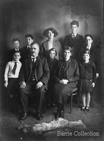
Photograph, Charles Ernest and Jessie Barrie with family, Unknown
This document is has been compiled by Wendy Barrie daughter of Ernest (Bon) and Edna Barrie and granddaughter of Charles E and Jessie M Barrie. I was born in during WW 11 and the first child of my generation to live on the ‘ Darlingsford’ property at Melton. My grandfather was well known in the district and was mostly referred to as Ernie. He shared the same initials as his second son Edgar. His three eldest sons lived and farmed in Melton for their entire lives. His descendants are still associated with farming, engineering and earthmoving in Melton. Ernie Barrie operated a travelling Chaff Cutter in the St Arnaud area where his parents William and Mary Ann had taken up land at Coonooer West in 1873. Ernie commenced his working life with a team of bullocks and a chaff cutter. The earliest connection he had with Melton was in 1887. By the beginning of the 20th century Ernie and his father William and brothers, William, Samuel, James Edwin,[Ted] Robert, Arthur and Albert have been associated with farming and milling in the Melton district. In the early 1900’s Ernie and his brother Ted were in partnership in a Chaff cutting and Hay processing Mill on the corner of Station and Brooklyn road Melton South. The mill was managed by William for a time. By 1906 Charles Ernest and James Edwin were in partnership in the Station Road mill when a connecting rail line across Brooklyn Road for a siding was constructed to the Melton Railway Station. In 1911 the Mill’s letterhead shows C.E. BARRIE Hay Pressing and Chaff Cutting Mills. Melton Railway Station. Telephone No 1 Melton. This Mill as sold to H S K Ward in 1916 and stood until 1977 when it burnt down in a spectacular fire. Ernie built a house at Melton South beside the Chaff Mill at Station Road in 1906 and married Jessie May Lang in August at the Methodist Church. Jessie’s father was Thomas Lang. He came to Melton in 1896 and was the Head Teacher at Melton State School No 430 until he retired in 1917. They had 9 children with 8 surviving to adulthood. Jessie and Ernie had 6 sons and 3 daughters. All the children lived at Darlingsford. In April 1910 the family left Melton for a brief period and moved to a farm in Trundle in NSW. They returned to Melton and purchased Darlingsford in May 1911. For a time during WW1 they lived at Moonee Ponds near the Lang grandparents at Ascot Vale. Mary and Bon attended Bank St State School. The children developed diphtheria in 1916 and their youngest boy, Cecil died of complications. Mary and Bon were taken to Fairfield Hospital and both recovered. At the end of the war influenza broke out the family returned to Darlingsford and shared the home for a short while with the Pearcey family who had been working the farm. By 1922 the family had and grown and Edgar, Tom, Horace, Jessie, Joyce and Jim were living a Darlingsford. Ernie continued during the 1920’s working the farm and attend his many civic and community commitments. Two 8 clydesdale horse teams were used to work the land which meant early rising for the horses to be fed and harnessed to commence the days work. In 1916 Ernie also became involved in a Chaff Mill on the corner of Sunshine and Geelong Road West Footscray, which at the time was being run by John Ralph Schutt. It was known an Schutt Barrie. A flour mill was added at a later stage. Other Schutt and Barrie mills were situated at Parwan and Diggers Rest. Another mill was situated beside the railway line at Rockbank. The Footscray mill ceased operation in 1968 Ernie spent a lot of time and energy at the Parwan Mill and travelling around Parwan and Balliang farms, where he came to know many of the families in the district. Ernies commitment to the civic development to the Melton and district was extensive, he was involved with a number of large events during the 1920’s such as the Melton Exhibitions and the 1929 Back to Melton Celebrations. He was a member of the Australian Natives Association at the turn of the century. He was Chairman of the School Committee at Melton State School 430 and the Melton South State School in thw1920s. He donated the land for a Hall for Melton South in 1909, known as Exford Hall and later in 1919 renamed Victoria Hall. The Hall was demolished in 1992. He was a Councillor, JP, and Vice President and President of the Melton Mechanics Institute Hall Committee in 1915- 1916. He was a member of the Methodist Church and later the Scots Presbyterian Church. He was Superintendent of the Sunday School of the Methodist Church to 1910 and later Scots Presbyterian Church until 1931. This is reflected in the theme of children in the stained glass window which was dedicated in his memory by his wife Jessie as a gift to the Scots Church. Charles Ernest Barrie made many generous donations to many charities who supported young people and children. In 1918 Jessie and Ernie made the first donation to a very prominent Victorian charity whose work still continues. Yooralla. In July 1931 Ernie’s untimely death was a major blow to the family and the Melton community. To this day people still vividly recall the day they lined the streets for his funeral. The day of the funeral is recalled as the day Melton stood as two of their prominent citizens who tragically died on the same day. Their eldest daughter Mary had married Keith Robinson in 1930 and had just moved to Heatherdale Toolern Vale with their year old baby son. Bon the eldest son was 22, Edgar 18, Tom 16, Horace 15, Jessie and Joyce 10 and Jim 8 years old. A heavy burden of responsibility fell on the shoulders of the two eldest children, Mary particularly for her mother and Bon stepped in assuming head of the family for his mother, brothers and sisters living at the Darlingsford homestead. In the early 1930’s the three eldest sons took on many of the Civic and Church commitments which their father had held. This community involvement extended well into the 1980s. In 1941 Bon married Edna Myers and they moved into a house shifted from Harkness Lane to Harkness Lane on the eastern section of the Darlingford property. Edgar married Margaret Hodgkinson a Primary school teacher at Melton in 1949 and they lived in the Darlingsford house. Earlier Tom married May Ferris and lived on the eastern side of Ferris Lane in the Ferris home. Bon , Edgar and Tom often operated as a team effort, in particular at harvest time when a larger team of workers was needed. The three farms cultivated wheat, barley and oats and supplied the Mill with sheafed hay. They continued using horse teams until mechanisation in the 1940’s made the horses redundant. By the 1960s their five sons continued with farming. Many loads of hay were transported to the Mill in Footscray. Well into the 1960s hired harvest hands along with agricultural university students were involved in bringing in he harvest. Stacking was an art form in itself and Tom held the expertise for building and shaping the sides and roof. The stacks built in the district each had their own unique shape and could be recognized by their builders. The Barrie brothers developed a mechanical fork lift for picking up complete stooks and moving them to be loaded to the elevator to build the haystack. The prototype built by Bill Gillespie was attached to a Bedford truck. Later refinements in a collaborative effort with the Gillespie brothers a multi pronged fork was attached to the front of tractor which was hydraulically operated to raise each stook onto trucks to be transported to the site of the haystacks. This method of handling sheaves significantly reduced laborious pitchforking individual sheaves. This invention was soon taken up by farmers far and wide and was a common sight in the district at harvest time in the stacking season. I recall visiting farmers calling in at the house at Ferris Road farm to inspect this break through invention. The Clydesdale horse teams were used into the 1940s but by the 1950s the Barries’ farms were fully mechanised. When the demand for sheafed hay declined other crops were introduced these included barley, lucerne, wheat and peas. Sheep were added to the mix in the 1950s in an attempt to keep the farms more viable. In the 1970s part of the Barrie’s farms were facing a major disruption with the impending compulsorily acquisition of a strip of land for the construction the freeway bypass, which divided access between the Darlingsford homestead with those on Ferris Lane. Charles Ernest Barrie and Jessie May Lang's children: 1. Mary Ena BARRIE was born on 07 October 1907. She died on 29 April 1999. 2. Ernest Wesley BARRIE was born on 29 April 1909 in Ascot Vale, Victoria, Australia.He died on 25 December 1985 in Melton, Victoria, Australia. 3. Cecil William BARRIE was born on 23 February 1911.He died on 25 May 1916. 4. Charles Edgar BARRIE was born on 01 June 1913.He died on 06 October 1975. 5. Thomas Lindsay BARRIE was born on 25 November 1914.He died on 14 September 1990 in Melton, Victoria, Australia. 6. William Horace BARRIE was born on 11 October 1915.He died on 19 December 1950. 7. Jessie Maud BARRIE was born on 06 November 1920 in Bacchus Marsh, Victoria, Australia.She died on 26 February 1994. 8. Dorothy Joyce BARRIE was born on 06 November 1920 in Bacchus Marsh, Victoria, Australia.She died on 18 March 2003.. 9. James Edward BARRIE was born on 17 January 1922 in Bacchus Marsh, Victoria, Australia.He died on 23 August 2004Family Photo with Edgar, Tom, Mary, Ernest (Bon), Horace, Jim, Charles Ernest, Jessie and Joycelocal identities -
 Mont De Lancey
Tool - Bag Hook, Unknown
Used in the late 18th or early 19th century.A small steel double curved pointy hooked bag hook with a turned wooden handle on the top. The handle is attached through a hole in the steel and riveted to the the hook. It was used to assist with lifting large bags of wheat, fertiliser and so on in the late 18th or early 19th century. agricultural equipment, farm equipment, bag hooks -
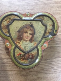 Mont De Lancey
Tin, Swallow & Ariell, Ltd
Biscuit tin: late 19th century Swallow & Ariell operated continuously in Port Melbourne from 1858 to 1991. The former Swallow & Ariell’s factory buildings, now The Anchorage, continue to add interest and pleasure along Stokes, Rouse and Princes Streets. Thomas Swallow, born in Reading, travelled to California and Ballarat before setting up a business making ships biscuits in Port Melbourne. His business partner Ariell died in 1877. He then went into partnership with Frederick Derham, his son in law. Company farms around Shepparton provided much of its wheat, and after 1889 most was ground into flour on the Port Melbourne premises. For the year ending 1 May 1920, the factory used 51 tons of butter, 2,740 eggs and produced more than 66 lines of biscuits. They also made puddings, elaborate cakes and ice cream. S & A was a significant employer – locally referred to as S & A College. At the height of the South African war it employed 1900 workers but even in 1991 it employed 450 people.Pink and brown clover-shaped ornamental biscuit tin decorated with pictures of a girl (central panel), 2 dogs (lower section), 2 rabbits (upper left-side panel) and 2 birds (upper right-hand panel. It has floral designs around the outer edges of both the tin and the lid which is hinged at the top of the tin.Inside the lid: "Swallow & Ariell, Ltd. Biscuit Manufacturers, Port Melbourne. Prizes received at all international & inter-colonial exhibitions"biscuit tins, tins -
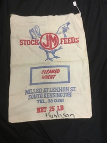 Mont De Lancey
Bag - Calico
Milled at Lennon St. South Kensington. Tel. 33 0261.One stock feed calico bag.Stock "JM" Feeds. Cleaned wheat. Net 25 LB. Hughson.bags, wheat -
 Wodonga & District Historical Society Inc
Map - Boorgunyah - "The Town that never was"
At the height of the river trade, there was a town surveyed and laid out, and streets were named. This town was to house the workers at the river port of Red Bank when the paddle steamers plied the Murray River as far as Albury, carrying produce such as wool and wheat to the various towns along the river in the 1800s. As the river trade died away, this town never went ahead – one might say, “The town that never was.” A lone gum tree stands on the site today.This item is significant because it documents plans which were made for the early development of Wodonga.A black an white map depicting the proposed location of the township. The map is based on a sketch and is not to scale,early wodonga, boorgunyah - "the town that never was", wodonga heritage -
 Eltham District Historical Society Inc
Photograph - Digital Photograph, Alan King, Panton Hill Hotel, 27 March 2008
Today’s Panton Hill Hotel was built around 1920. Published: Nillumbik Now and Then / Marguerite Marshall 2008; photographs Alan King with Marguerite Marshall.; p61 Panton Hill was originally known as Kingstown, and consisted of only one hotel when the Orams Reef was discovered in 1859. Kingstown was a quartz mining centre and many old mine shafts remain in the area. Orams Reef was one of the first reefs with a rich find of gold in the area. The Hotel Francais, which had been operating in 1861, was well situated on the way to Queenstown (later St Andrews). So was Herr Hirt’s Hotel and store at Smiths Gully. The Kingstown hotel, known as the Frenchman’s and in 1864 as the Hotel de France, was run by a Monsieur Emile Hude and his wife Jeanne, and known for its good food. They hosted social events, business conventions and debates, attracting patrons from as far as Melbourne. The hotel’s name was changed to Panton Hill Hotel in 1905. In 1883 Charles Caudwell built another hotel nearby, possibly in Long Gully Road,3 which it is thought, was burnt down early last century. Today’s Panton Hill Hotel, built around 1920, is the only one of the cluster of buildings in the main road, not to date from around the turn of last century. It was severely damaged by fire in 2003, then underwent extensive alterations. It is the township’s only hotel and is an example of a modest hotel building exterior, constructed early last century. In its early days the hotel also housed the first post office, newsagency and store. Orams Reef yielded a total of £100,000, and fossikers also found alluvial gold in the creeks and gullies, but there is no record of the total value of their finds. Gold greatly increased the Panton Hill population, which peaked between 1865 and 1885. On holidays large sports meetings were held with wood chopping contests and foot races and the day would end with a ball. Miners came from various countries to seek their fortune, including many from China. The Chinese became unpopular however, and gradually left the district, although some stayed and grew and sold vegetables.5 Panton Hill was named after Joseph Panton, who in 1862 was appointed Police Magistrate for the Woods Point, Heidelberg and Yarra districts. Panton was an outstanding man, who in 1852, was Commissioner of Crown Lands and Assistant Commissioner of Goldfields at Bendigo. In 1874 he was promoted to Chief Magistrate for the Melbourne Police. Panton was also an artist, becoming president of the Victorian Arts Society in 1888, and in 1913, president of the Royal Geographical Society. Despite Panton Hill’s prosperity, it still lacked many services as poor roads made access to Melbourne difficult. A horse-drawn mail coach travelled to Melbourne until 1890, when the railway came to Heidelberg. The nearest doctor was at Yarra Glen or Heidelberg, and the Indian hawker Singh’s annual visit was very welcome. A miner’s shack opposite the school was used as a post office. Today’s general store and post office in the main road dates from early last century, and has changed considerably. While most people searched for gold, the more enterprising ones established farms to feed the diggers. Farmers grew wheat, barley and oats, and sent animal skins to the Eltham tannery, to make furs in Melbourne. As gold became scarce from around 1880, miners took up farming on 19 to 20 acre (8ha) allotments. The first settlers in Cherry Tree Road included Purcell, Smith, Owens, Hughes and Shillinglaw. By 1900 all the land had been taken up around Panton Hill and Hurstbridge. The orchards in Panton Hill and the wider district, particularly of apple and pear, were very successful, and made Panton Hill a cohesive and successful community. About 1914 the Moores built the first cool-store and refrigeration plant at their orchard in Cherry Tree Road. Many settlers planted vineyards and made high quality wine, but in 1922 the blight destroyed them.This collection of almost 130 photos about places and people within the Shire of Nillumbik, an urban and rural municipality in Melbourne's north, contributes to an understanding of the history of the Shire. Published in 2008 immediately prior to the Black Saturday bushfires of February 7, 2009, it documents sites that were impacted, and in some cases destroyed by the fires. It includes photographs taken especially for the publication, creating a unique time capsule representing the Shire in the early 21st century. It remains the most recent comprehenesive publication devoted to the Shire's history connecting local residents to the past. nillumbik now and then (marshall-king) collection, panton hill hotel -
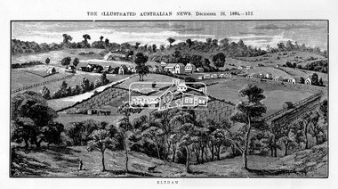 Eltham District Historical Society Inc
Photograph, Samuel Calvert, Eltham, The Illustrated Australian News, December 26, 1884, p212, 1884
A description in the newspaper near the illustration (page 210) reads as follows: "Eltham is a pretty little township on the Yarra Flats road, about 14 miles east north east of Melbourne, from which place there is communication by way of Heidelberg. It has a population of nearly 400 inhabitants, but in addition it is the centre of a large district extending over about 203 square miles, having a population of 2344. The land in the district is mostly used for grazing purposes, although as a rule the small farms grow a good deal of wheat, oats and other agricultural produce. A large quantity of fruit, especially raspberries and strawberries, is also produced, the rich alluvial flats along the creek upon which the township is situated being very well adapted for that purpose. Gold has also been found in the vicinity of the township, but not in remunerative quantities". This photo forms part of a collection of photographs gathered by the Shire of Eltham for their centenary project book,"Pioneers and Painters: 100 years of the Shire of Eltham" by Alan Marshall (1971). The collection of over 500 images is held in partnership between Eltham District Historical Society and Yarra Plenty Regional Library (Eltham Library) and is now formally known as 'The Shire of Eltham Pioneers Photograph Collection.' It is significant in being the first community sourced collection representing the places and people of the Shire's first one hundred years.Digital imageshire of eltham pioneers photograph collection, eltham, illustrated australian news -
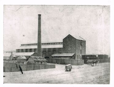 Bendigo Historical Society Inc.
Photograph - WES HARRY COLLECTION: STONE INDUSTRIAL BUILDING, CHIMNEY
Black and white photo, image: large stone industrial building, brick chimney, stacks of wood. Man standing on top floor operating winch. Horse and wagon beneath, loaded with bags of ( could be wheat ? ) On LH side of image, picket fence surrounds large amount of cut wood - cut to equal length. Slab and bark roof hut on road adjoining large building , various smaller buildings to back of hut. Batchelder carriage in centre of image. Batchelderindustrial stone building, batchelder -
 Eltham District Historical Society Inc
Photograph - Digital Photograph, Alan King, Blue Lake, Plenty Gorge Park, 2008
A quarry was transformed into the Blue Lake. Published: Nillumbik Now and Then / Marguerite Marshall 2008; photographs Alan King with Marguerite Marshall.; p179 The dramatic steep-sided Plenty Gorge lies along the divide of two geological areas, and separates the Nillumbik Shire and the City of Whittlesea. On the Nillumbik side are undulating hills and sedimentary rock, and in Whittlesea, lies a basalt plain formed by volcanic action up to two million years ago. This provides the Plenty Gorge Park with diverse vegetation and habitats, making it one of Greater Melbourne’s most important refuges for threatened and significant species. The park, established in 1986, consists of around 1350 hectares, and extends 11 kilometres along the Plenty River, from Greensborough to Mernda. It provides a wildlife corridor for around 500 native plant and 280 animal species. The area’s plentiful food and water attracted the Wurundjeri Aboriginal people and then European settlers. By 1837 squatters had claimed large runs of land for their sheep and cattle. The Plenty Valley was among the first in the Port Phillip District to be settled - mainly in the less heavily timbered west - and was proclaimed a settled district in 1841.But by the late 1880s, the settlers’ extensive land clearing for animal grazing, then agriculture, depleted the Wurundjeri’s traditional food sources, which helped to drive them away. Many Wurundjeri artefacts remain (now government protected), and so far 57 sites have been identified in the park, including scarred trees, burial areas and stone artefacts. Pioneer life could be very hard because of isolation, flooding, bushfires and bushrangers. Following the Black Thursday bushfires of 1851, basalt was quarried to build more fire-resistant homes. Gold discoveries in the early 1850s swelled the population, particularly around Smugglers Gully; but food production made more of an impact. In the late 1850s wheat production supplanted grazing. In the 1860s the government made small holdings available to poorer settlers. These had the greatest effect on the district, particularly in Doreen and Yarrambat, where orchards were established from the 1880s to 1914. Links with a prominent early family are the remains of Stuchbery Farm, by the river’s edge bounded by Smugglers Gully to the north and La Trobe Road, Yarrambat, to the east. The Stuchberys moved to the valley in 1890, and the family still lives in the area. In 1890, Alfred and Ada first lived in a tent where four children were born, then Alfred built the house and outbuildings around 1896. They planted an orchard, then a market garden, and developed a dairy. The family belonged to the local Methodist and tennis communities. Their grandson Walter, opened the Flying Scotsman Model Railway Museum in Yarrambat, which his widow, Vi, continues to run. Wal was also the Yarrambat CFA Captain for 22 years until 1987. Walter sold 24 hectares in 1976 for development - now Vista Court - and in 1990, the remaining 22.6 hectares for the park. Remaining are an early stone dairy and remnants of a stone barn, a pig sty and a well. Until it was destroyed by fire in 2003, a slab hut stood on the Happy Hollow Farm site, at the southern end of the park. The hut is thought to have been built in the Depression around 1893. This was a rare and late example of a slab hut with a domestic orchard close to Melbourne. Emmet Watmough and his family first occupied the hut, followed by a succession of families, until the Bell family bought it around 1948. There they led a subsistence lifestyle for 50 years, despite encroaching Melbourne suburbia. The Yellow Gum Recreation Area includes the Blue Lake, coloured turquoise at certain times of the year. Following the 1957 bushfires, this area was quarried by Reid Quarries Pty Ltd for Melbourne’s first skyscrapers, then by Boral Australia. However in the early 1970s water began seeping into the quarry forming the Blue Lake and the quarry was closed. The State Government bought the site in 1997 and opened it as a park in 1999.This collection of almost 130 photos about places and people within the Shire of Nillumbik, an urban and rural municipality in Melbourne's north, contributes to an understanding of the history of the Shire. Published in 2008 immediately prior to the Black Saturday bushfires of February 7, 2009, it documents sites that were impacted, and in some cases destroyed by the fires. It includes photographs taken especially for the publication, creating a unique time capsule representing the Shire in the early 21st century. It remains the most recent comprehenesive publication devoted to the Shire's history connecting local residents to the past. nillumbik now and then (marshall-king) collection, blue lake, plenty gorge park -
 Eltham District Historical Society Inc
Photograph - Digital Photograph, Marguerite Marshall, Stuchbery Farm dairy, 14 March 2008
Stuchbery Farm was situated on the Plenty River bounded by Smugglers Gully to the north and La trobe Road, Yarrambat, to the east. Alan and Ada Stutchbery moved to the valley in 1890, first living in a tent where four children were born. Alfred built a home and outbuildings around 1896. They planted an orchard, then a market garden and developed a dairy. Published: Nillumbik Now and Then / Marguerite Marshall 2008; photographs Alan King with Marguerite Marshall.; p179 The dramatic steep-sided Plenty Gorge lies along the divide of two geological areas, and separates the Nillumbik Shire and the City of Whittlesea. On the Nillumbik side are undulating hills and sedimentary rock, and in Whittlesea, lies a basalt plain formed by volcanic action up to two million years ago. This provides the Plenty Gorge Park with diverse vegetation and habitats, making it one of Greater Melbourne’s most important refuges for threatened and significant species. The park, established in 1986, consists of around 1350 hectares, and extends 11 kilometres along the Plenty River, from Greensborough to Mernda. It provides a wildlife corridor for around 500 native plant and 280 animal species. The area’s plentiful food and water attracted the Wurundjeri Aboriginal people and then European settlers. By 1837 squatters had claimed large runs of land for their sheep and cattle. The Plenty Valley was among the first in the Port Phillip District to be settled - mainly in the less heavily timbered west - and was proclaimed a settled district in 1841. But by the late 1880s, the settlers’ extensive land clearing for animal grazing, then agriculture, depleted the Wurundjeri’s traditional food sources, which helped to drive them away. Many Wurundjeri artefacts remain (now government protected), and so far 57 sites have been identified in the park, including scarred trees, burial areas and stone artefacts. Pioneer life could be very hard because of isolation, flooding, bushfires and bushrangers. Following the Black Thursday bushfires of 1851, basalt was quarried to build more fire-resistant homes. Gold discoveries in the early 1850s swelled the population, particularly around Smugglers Gully; but food production made more of an impact. In the late 1850s wheat production supplanted grazing. In the 1860s the government made small holdings available to poorer settlers. These had the greatest effect on the district, particularly in Doreen and Yarrambat, where orchards were established from the 1880s to 1914. Links with a prominent early family are the remains of Stuchbery Farm, by the river’s edge bounded by Smugglers Gully to the north and La Trobe Road, Yarrambat, to the east. The Stuchberys moved to the valley in 1890, and the family still lives in the area. In 1890, Alfred and Ada first lived in a tent where four children were born, then Alfred built the house and outbuildings around 1896. They planted an orchard, then a market garden, and developed a dairy. The family belonged to the local Methodist and tennis communities. Their grandson Walter, opened the Flying Scotsman Model Railway Museum in Yarrambat, which his widow, Vi, continues to run. Wal was also the Yarrambat CFA Captain for 22 years until 1987. Walter sold 24 hectares in 1976 for development - now Vista Court - and in 1990, the remaining 22.6 hectares for the park. Remaining are an early stone dairy and remnants of a stone barn, a pig sty and a well. Until it was destroyed by fire in 2003, a slab hut stood on the Happy Hollow Farm site, at the southern end of the park. The hut is thought to have been built in the Depression around 1893. This was a rare and late example of a slab hut with a domestic orchard close to Melbourne. Emmet Watmough and his family first occupied the hut, followed by a succession of families, until the Bell family bought it around 1948. There they led a subsistence lifestyle for 50 years, despite encroaching Melbourne suburbia. The Yellow Gum Recreation Area includes the Blue Lake, coloured turquoise at certain times of the year. Following the 1957 bushfires, this area was quarried by Reid Quarries Pty Ltd for Melbourne’s first skyscrapers, then by Boral Australia. However in the early 1970s water began seeping into the quarry forming the Blue Lake and the quarry was closed. The State Government bought the site in 1997 and opened it as a park in 1999.This collection of almost 130 photos about places and people within the Shire of Nillumbik, an urban and rural municipality in Melbourne's north, contributes to an understanding of the history of the Shire. Published in 2008 immediately prior to the Black Saturday bushfires of February 7, 2009, it documents sites that were impacted, and in some cases destroyed by the fires. It includes photographs taken especially for the publication, creating a unique time capsule representing the Shire in the early 21st century. It remains the most recent comprehenesive publication devoted to the Shire's history connecting local residents to the past. nillumbik now and then (marshall-king) collection, ada stuchbery, alan stuchbery, dairy, stuchbery farm, farm buildings, yarrambat, plenty gorge park -
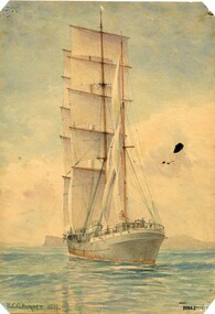 Flagstaff Hill Maritime Museum and Village
Painting - Watercolour Painting, Beni Carr Glyn Burnett, The Winterhude, 1933
Beni Carr Glyn Burnett (also known as B. C. G. Burnett or Beni Burnett) was born in 1889 to missionary parents in Mongolia. When he was 15 years old he began training as an architect with a firm in Shanghai. He worked in Singapore, Japan and China before moving to Australia around 1933. In 1937 he was appointed as the Commonwealth principal architect in the Northern Territory. He went on to design a series of houses for senior public servants and military personnel which became very popular as they were specifically designed for the tropics - incorporating louvres, high ceilings and good ventilation. When Darwin was bombed in February 1942, he was evacuated to Alice Springs where he continued to work as an architect. He also became a Magistrate and Coroner in Alice Springs. In later life he was well known for sketching clientele in public bars. He died in 1955. Beni Burnett was living in Sydney in 1933 when he produced these three artworks. There were several photography firms operating in Sydney at this time who specialised in photographing ships and the shipping trade (e.g. Samuel J. Hood and William James Hall) and whose photographs were used by artists to produce ship portraits. Both of these photographers took photographs of the two ships in B. C. G. Burnett's watercolours. The "Winterhude" (originally called "Mabel Rickmers) was a three masted Finnish barque built in 1898 by Rickers - Werft Bremerhaven for use on the East India rice trade and later the South American nitrate trade. After WW1 it came under French control as war compensation. It was also sold several times and at one stage was called "Selma Hemsoth" but in 1925 it was bought by Gustaf Erikson who restored the name "Winterhude" and the vessel became a regular transport in the Australian wheat trade. In 1944 it was sold to the German navy before being taken over by the British at the end of WW2. It was photographed in Sydney by William James Hall in1931 on its way to Port Lincoln, South Australia to load wheat for Europe.This painting (one of a set of three small artworks) is significant as an example of shipping (particularly the use of sailing ships) that were still being used as late as the 1930's in Australia. It is also important because its creator (B. C. G. Burnett) went on to become a well-known public figure in the Northern Territory in the late 1930's due to his innovative approach to designing homes for the tropical climate.A watercolour painting of a sailing ship called "Winterhude". It shows a 3 masted barque with a blue and red steel hull in full sail heading away from the viewer. A small figure can be seen at the wheel at the rear of the ship. The painter's name (B. C. G. Burnett) and date (1933) are written on the bottom left-hand corner of the painting. The name of the ship is written in faded pencil on the back of the painting.front - "B. C. G. BURNETT. 1933" back - in faded pencil - "the Winterhude"flagstaff hill maritime museum and village, warrnambool, great ocean road, sailing ships, ships, barque, winterhude, beni carr glyn burnett, b. c. g. burnett, beni burnett, painting, watercolour painting, sketch, ink sketch, sydney harbour, architect, darwin, burnett house, photography, samuel j. hood, william james hall, mabel rickmers -
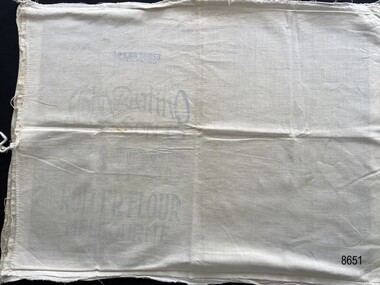 Flagstaff Hill Maritime Museum and Village
Textile - Flour Bag Pillowcase
Flour bags were a useful source of material to be repurposed into domestic objects in the early 20th century. This object, fashioned from two well-known brands of flour bag, was most likely used as a pillowcase.The pillowcase provides an example of how flour bags were recycled and repurposed into useful domestic objects in the early 20th century.Two flour bags opened out and sewn together to create a possible pillowcase. The open end has a tie sewn to each side to enable the pillowcase to be closed. The bags have been sewn with the inscriptions on the inside of the pillowcase.Side 1 25LBS GROSS WHEN PACKED, John Darling & Son, ECLIPSE, ROLLER FLOUR, MELBOURNE Side 2 O-SO-LITE, Self-raising, FLOUR, Creamy & Delicious, O-SO-LITE PRODUCTS, 412 COLLINS ST MELBOURNE, C.I. Decoration of wheat stalks surround the inscription.flagstaff hill maritime museum and village, great ocean road, shipwreck coast, warrnambool, calico, domestic object, textile, food storage, john darling & son, eclipse roller flour, o-so-lite flour, pillowcase, flour bag -
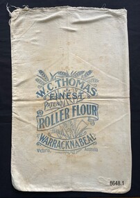 Flagstaff Hill Maritime Museum and Village
Textile - Flour bag - W.C.Thomas, Warracknabeal
This flour bag came from the W.C. Thomas Flour Mill at Warracknabeal, Victoria. W.C. Thomas ran a number of flour mills throughout the Victorian wheat belt, with the Warracknabeal Mill operating from 1884 to 1964. After their use for flour storage, flour bags were able to be reused for bulk storage of other dry goods or sewn into domestic objects such as tea towels, pillowcases or waggas.This is a good example of a flour bag from a prominent Victorian flourmill, operating from the late 19th century to the mid-20th century.Calico flour bag for 'Roller Flour' from the flour mill of W.C. Thomas in Warracknabeal, a large wheat growing area in Victoria. The stencil on the front of the bag includes an image of wheat overlaid with the written information in scroll format.W.C. Thomas, Finest, Patent, Roller Flour, Warracknabeal, Victoria, Australia. Wheat image.flagstaff hill maritime museum and village, great ocean road, shipwreck coast, flour bags, calico, domestic object, textile, food storage, w.c. thomas, warracknabeal, flour mill -
 Flagstaff Hill Maritime Museum and Village
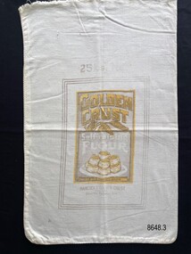
Textile - Flour bag - Golden Crust
Flour bags were used when purchasing flour from the late 19th century to the mid 20th century. They were able to be reused for bulk storage of dry goods or sewn into domestic objects such as tea towels, pillowcases or waggas.The flour bag provides an example of a useful domestic packaging product, from the early 20th century.Calico flour bag for Golden Crust Self-raising flour, 25lb. The stencil on the bag includes the manufacturer’s address and images of heads of wheat and a plate of scones. 25lbs, Golden Crust, Self-raising Flour, Blended with Phosphate Aerator, Hancock’s Golden Crust Pty.Ltd. South Yarra, Vicflagstaff hill maritime museum and village, great ocean road, shipwreck coast, calico, domestic object, textile, food storage, flour bag, golden crust -
 Flagstaff Hill Maritime Museum and Village
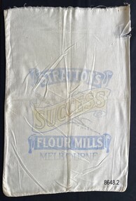
Textile - Flour bag - Stratton's, Melbourne
Flour bags were used when purchasing flour from the late 19th century to the mid 20th century. They were able to be reused for bulk storage of dry goods or sewn into domestic objects such as tea towels, pillowcases or waggas.The flour bag provides an example of a useful domestic packaging product, from the early 20th century.Calico flour bag for 'Success Flour' from Stratton’s flour mill in Melbourne. The stencil on the front of the bag includes the image of a wheat stalk overlaid with the written information in scroll format.Stratton's, Success, Flour Mills, Melbourneflagstaff hill maritime museum and village, great ocean road, shipwreck coast, calico, domestic object, textile, food storage, stratton's, flour bag -
 Bendigo Historical Society Inc.
Newspaper - JENNY FOLEY COLLECTION: ON THE ROAD
BHS CollectionBendigo Advertiser ''The way we were'' from Monday, May 27, 2002. On the road: Arthur Packham, Agnes and Olive Perret, William Packham with Arthur and Bill Packham on the wagon cart wheat to Llanelly by wagon in 1930. The clip is in a folder.newspaper, bendigo advertiser, the way we were