Showing 574 items
matching 1840
-
 Bacchus Marsh & District Historical Society
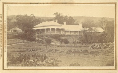
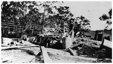
Photograph, Glenmore Homestead 1883
This homestead was built by Charles Griffith on a 55,000 acre Run. It replaced an earlier dwelling which was a slab hut with a bark roof. Charles Griffith, an Irish barrister, with his friend, James Moore, settled on Glenmore Station in the Parwan Valley in 1840. Their partnership lasted until 1848. In 1846, whilst in Ireland, Griffith married Miss Jane Catherine Magee, then returned to Glenmore and later took his nephew, Molesworth Richard Greene, into partnership, which arrangement proved to be long and prosperous. In 1857, they bought runs at Mount Hope and Mount Pyramid, which they kept until the days of free selection. Griffith led an active and successful public life.He was a member of the new Victorian Legislative Council in 1851, and was later an elected representative of the Legislative Assembly 1853-1859. He occupied many important public positions, including that of magistrate for Bacchus Marsh. Griffith was a devout Anglican and hosted Bishop Charles Perry at his station near Bacchus Marsh in 1849. He died in 1863 at his home in South Yarra.Small sepia unframed photograph on card with gold border framing photograph. Housed in the album, 'Photographs of Bacchus Marsh and District in 1883 by Stevenson and McNicoll'. The photograph shows a view of an extensive single-storey homestead consisting of three adjoining buildings, with a further building on the left of the main property. The series of three buildings is built in an elevated position, with pathways leading through a garden. At the front there is a vegetable garden which seems to be still in a state of development. The main house, possibly of brick, is set at an angle to the other two in this complex. It has a hip roof with a concave verandah on two sides with arched barge boards and simple unadorned pillars. There appears to be a hammock slung between two pillars. Two chimneys can be seen on this dwelling.The adjoining building is of a simpler design, with a lower roof line and a verandah running along the front. Two chimneys can be seen, one emitting smoke. This middle building may be a kitchen and rooms for day-to-day use. The third building is also of a simpler design, with a gable above a verandah. The purpose of this building is less clear. The different styles of construction suggest that these buildings were built separately at different times for different purposes. To the left of the main group of buildings is another cottage, smaller and of a simpler design. A fence runs along the front, clearly separating this building from the others, suggesting it may have been the dwelling of an overseer.On the front: Stevenson & McNicoll. Photo. 108 Elizabeth St. Melbourne. COPIES CAN BE OBTAINED AT ANY TIME. On the back: LIGHT & TRUTH inscribed on a banner surmounted by a representation of the rising sun. Copies of this Portrait can be had at any time by sending the Name and Post Office Money Order or Stamps for the amount of order to STEVENSON & McNICOLL LATE BENSON & STEVENSON, Photographers. 108 Elizabeth Street, MELBOURNE. stevenson and mcnicoll 1883 photographs of bacchus marsh and district, farms bacchus marsh, charles james griffith 1808-1863, glenmore station -
 Mont De Lancey
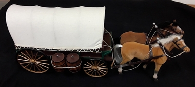
Decorative object - Conestoga Wagon, Mr Chas W Davis, Unknown
The collection of thirteen model horse drawn vehicles were carefully handmade by Mr Chas W Davis 1925 - 2002. He was a talented artist and saw doctor. This model of a horse drawn Canestoga Wagon replicates the vehicle that enjoyed respect from the public during the 1880's. A model of a long covered Conestoga Wagon with two horses, brown and tan. The cream fabric covers curved shaped metal bands and is laced with string around the base to attach it to the wagon.It has a green base, green wooden seat and footrest. There are two wooden barrels attached by wire on one side and the other side has a luggage box. It has two small gold painted spoked wheels with painted black tyres at the front and two larger ones at the back. The forerunner of the Conestoga Wagon had its origin in Europe as a mobile home for shepherds and nomads in the early 1800's. The east coast of America became home to people from all over Western Europe so the old wagon designs were carried to the New World. The wagons were named after a river in Lancaster County Pennsylvania where the Stutz family built them for the western treks of history. Fondly known as the 'Prairie Schooner', the cost in 1840 was $48.00, unpainted spare wheels $8.00, Lawson axles $12.00. They came in 12 and 14 feet beds.replicas, models, scale models, vehicles, carriages, horse drawn vehicles, toy horses, drays -
 Mont De Lancey
Decorative object - Conestoga Wagon, Mr Chas W Davis, Unknown
The collection of thirteen model horse drawn vehicles were carefully handmade by Mr Chas W Davis 1925 - 2002. He was a talented artist and saw doctor. This model of a horse drawn Canestoga Wagon replicates the vehicle that enjoyed respect from the public during the 1880's. A model of a long covered Conestoga Wagon with two horses, brown and tan. The cream fabric covers curved shaped metal bands and is laced with string around the base to attach it to the wagon.It has a green base, green wooden seat and footrest. There are two wooden barrels attached by wire on one side and the other side has a luggage box. It has two small gold painted spoked wheels with painted black tyres at the front and two larger ones at the back. The forerunner of the Conestoga Wagon had its origin in Europe as a mobile home for shepherds and nomads in the early 1800's. The east coast of America became home to people from all over Western Europe so the old wagon designs were carried to the New World. The wagons were named after a river in Lancaster County Pennsylvania where the Stutz family built them for the western treks of history. Fondly known as the 'Prairie Schooner', the cost in 1840 was $48.00, unpainted spare wheels $8.00, Lawson axles $12.00. They came in 12 and 14 feet beds.replicas, models, scale models, vehicles, carriages, horse drawn vehicles, toy horses, drays -
Mont De Lancey
Decorative object - Conestoga Wagon, Mr Chas W Davis, Unknown
The collection of thirteen model horse drawn vehicles were carefully handmade by Mr Chas W Davis 1925 - 2002. He was a talented artist and saw doctor. This model of a horse drawn Canestoga Wagon replicates the vehicle that enjoyed respect from the public during the 1880's. A model of a long covered Conestoga Wagon with two horses, brown and tan. The cream fabric covers curved shaped metal bands and is laced with string around the base to attach it to the wagon.It has a green base, green wooden seat and footrest. There are two wooden barrels attached by wire on one side and the other side has a luggage box. It has two small gold painted spoked wheels with painted black tyres at the front and two larger ones at the back. The forerunner of the Conestoga Wagon had its origin in Europe as a mobile home for shepherds and nomads in the early 1800's. The east coast of America became home to people from all over Western Europe so the old wagon designs were carried to the New World. The wagons were named after a river in Lancaster County Pennsylvania where the Stutz family built them for the western treks of history. Fondly known as the 'Prairie Schooner', the cost in 1840 was $48.00, unpainted spare wheels $8.00, Lawson axles $12.00. They came in 12 and 14 feet beds.replicas, models, scale models, vehicles, carriages, horse drawn vehicles, toy horses, drays -
 Flagstaff Hill Maritime Museum and Village
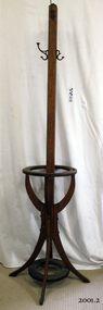
Coat rack
A hat coat and umbrella stand is a device used to store hats and often coats on, and umbrellas within. Some catalogues in Europe marketed this furniture as a portmanteau from the French words Porter (carry) and Manteau (cloak). The front hall was the introduction to the house, and as such was an important part of the Victorian home. Furnishings were selected not only to make it a useful place to hang a hat and coat, store an umbrella and leave a calling card but also to show family wealth, social position and knowledge of current styles. A hall stand or a hat rack was the most important piece of furniture in homes at this time. New and more elaborate designs began to appear about 1840, as homes became larger and social visits became more structured. Usually made of wood and standing at least 1.5 meters tall, they have a single-pole making up most of the height, with a sturdy base to prevent toppling, and an array of lengthy pegs or hooks at the top for placement of hats. Smaller houses had smaller front halls, so a single-pole type as by the 1920s houses had become smaller. A household furniture item possibly from the 1920s that was common in houses from the early 1840s, it's significance is social, demonstrating how furniture trends change over time with the more elaborate the item the more social standing was attributed to the owners' position in society. even today persons association and ownership with inanimate objects tend to represent their social standing along with their financial and community acceptability. Coat rack with four curved legs, circular holder for umbrellas and walking sticks. Four metal hooks, screwed onto main column of stand. Condition: one curved leg broken. 2 hooks broken.Noneflagstaff hill, warrnambool, shipwrecked-coast, flagstaff-hill, flagstaff-hill-maritime-museum, maritime-museum, shipwreck-coast, flagstaff-hill-maritime-village -
 Eltham District Historical Society Inc
Photograph, Willis Vale on the north bank of the Plenty River, Church Street, Greensborough, c.1950
Photo sourced from Heidelberg Historical Society reproduced on p63 of The Diamond Valley Story by Dianne H. Edwards, Shire of Diamond Valley 1979. "Willis Vale, Greensborough, situated on the north bank of the Plenty River at the end of Church Street. The home wasa built about 1840 by Jame Willis Mayger from bricks hand-made nearby. It was later passed to the Partington family and when this photo was taken the building was deserted. Vandals and finally a bushfire destroyed Willis Vale in the 1950s." Greensborough Historical Society has same image with more accurate information on the date/cause of fire damage https://victoriancollections.net.au/items/585b6c96d0ce2c1268f1c96b "House built by Edward Maygar, Robert Whatmough lived there mid 19th century and later sold to Partington family. It was located on the Plenty River at Partington's Flat Greensborough. The derelict Willis Vale house was destroyed in 1964 when a fire originating from North Plenty Gorge - Kurrak Road - was lit by two teenage boys and made its way several kilometres down to Partington's Flat Greensborough."Black and white copy of photo printed on glossy photographic paper 30.5 x 40.5 cm (12 x 16 inch); image size approx. 18.5 x 28 cmchurch street, diamond valley story, greensborough, james willis mayger, partington family, willis vale -
Glenelg Shire Council Cultural Collection
Photograph - Photograph - 'Stanton Drew', Portland, n.d
Stanton Drew was a two storey stucco rendered bluestone house was constructed in 1864 for Major Alexander Davidson, a Scottish born pastoralist who had earlier in 1848 settled on the Wando River near Casterton. Stanton Drew is a characteristic pattern book, regency gothic villa and virtually devoid of ornamentation save for unusually fenestrated bay windows and window label mouldings. Stanton Drew is a late example in Victoria of the primitive regency gothic style of villa architecture popularised by pattern books of the period 1840-60. The two storey house is an undistinguished design most notable for its associations with Western District pastoralist Alexander Davidson. No important historical associations are apparent, although the Davidson family lived in the residence until c.1908. Stanton Drew is in an extremely dilapidated state and has suffered badly form subsidence and lack of regular maintenance. The slate roof has been replaced with iron. The house was originally named Wando Villa by Davidson in memory of his time at Wando River. The house was renamed in 1938.Black and white photo. View of the front of 'Stanton-Drew' house, Portland.Back: 'STANTON-DREW, PORTLAND, VICTORIA, 1971' -handwritten black biro. Purple stamp 'ALEX PRIESTLEY BOX 155 PHONE 309 HEYWOOD VIC 3304'historic homestead, bluestone building, alexander davidson, pastoralist -
 Eltham District Historical Society Inc
Negative - Photograph, Construction of the new concrete bridge over the Diamond Creek on Main Road, Eltham, c.May 1926
Construction of the new concrete bridge over the Diamond Creek on Main Road, Eltham, c.May 1926. Viewed from northern approach looking south east towards Eltham Park (Eltham Lower Park), showing the power lines that used to run in front of the park. The original long suspension bridge over the Diamond Creek on Main Road at Eltham collapsed during flooding of the Diamond Creek on October 13 and 14, 1923. The original bridge was built around 1840 for the coach road when Cobb & Co.'s coach was the only conveyance between Eltham and Melbourne. Widespread damage was done in Melbourne and surrounding areas by floods resulting from the overflow of the Yarra at many points along its banks. A temporary bridge rigged up was severely damaged by the flooding of the creek and was closed to vehicular traffic in April 1924. A new concrete bridge was constructed to replace it and by May 1926 all the concrete piles and abutments had been completed. The bridge was finally completed and opened for traffic in September 1926, almost three years after it initially collapsed.This photo forms part of a collection of photographs gathered by the Shire of Eltham for their centenary project book,"Pioneers and Painters: 100 years of the Shire of Eltham" by Alan Marshall (1971). The collection of over 500 images is held in partnership between Eltham District Historical Society and Yarra Plenty Regional Library (Eltham Library) and is now formally known as the 'The Shire of Eltham Pioneers Photograph Collection.' It is significant in being the first community sourced collection representing the places and people of the Shire's first one hundred years.Digital image 4 x 5 inch B&W Negshire of eltham pioneers photograph collection, bridge, bridge construction, cement mixer, diamond creek (creek), eltham, eltham lower park, eltham south, main road bridge -
 Stawell Historical Society Inc
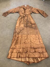
Costume, Brown Silk Taffeta Wedding Dress belonging to Johanna Draffin ne Bisset Simpson 1880, 1880
See Marriage Cert in Marriages File 1840-1885 Also Details in Simpson File Belonged to Johanna Simpson married Thomas Draffin on 17th Feb 1880 Presbyterian Church Stawell Silk Taffeta lined wedding dress. Ruffled collar. 18-inch waste. Full length sleeve. Ruched band on upper sleeve. Lower sleeve band attached with matching silk piping which extends into the band as decoration. Garment shaped with two long darts on either side of opening. Opening from neck to below hip uses metal hook and hand sewn eye closing. Lower dress in three sections. Top section is plain matching material attached to the upper garment with piping. Second panel is Ruched material the same material as upper garment. Third lower panel is same material as upper garment consisting of three bands of finely pleated material. Back has pocket on right hip with two pointed flaps and central pleated panel. Back has a Central Bustle extending from back hip to hem. Light Brown with pleated frills at bottom Miss Annie Draffin Mothers Wedding Frock 1880 -
 Bayside Gallery - Bayside City Council Art & Heritage Collection
Map, H.B. Foot, Plan of the Brighton Estate containing 5120 acres, first special survey at Port Phillip, c. 1842
This plan records the Brighton Estate, also known as Dendy's Special Survey. In 1840 Henry Dendy, a farmer in Surrey, England acquired a "Special Survey" from the Commissioners for Land and Emigration which gave him the right to choose land in Port Phillip for the low price of £1 per acre for 5120 acres. Dendy appointed Jonathan Binns Were, as his agent, who later became a partner. Together, Dendy and Were decided on an area 5 miles south from Melbourne, bounded by North Road, East Boundary Road, South Road and to the west by Port Phillip Bay. Their Brighton Estate was first surveyed by T. S. Townsend in May 1841 and was re-surveyed by Robert Hoddle. Dendy and Were were making plans to sell the land and advertised a 30-guinea prize for the best subdivision which was to be divided into a village, marine residences, suburban and cultivation allotments, with the remainder being divided into country sections. The competition was won by H.B. Foot, who planned the village around a reserve and crescents and a 'green belt' forming the town boundary. brighton estate, dendy's special survey, special survey, henry dendy, jonathan binns were, w.b. were, survey, plan, map, brighton, george ward cole, baker's lithographer, hibernian, subdivision, town planning, cartographic material, h.b. foot -
 Brighton Historical Society
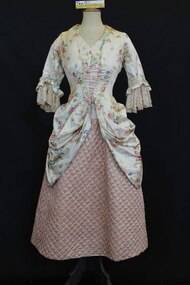
Clothing - Dress, Fancy dress, circa 1911
This dress is a 'Dolly Varden' or 'shepherdess" style costume worn by Ida Annie Wallace (1890-1976) on a sea voyage to China accompanying her parents in 1911. The BHS has a photo of Ida wearing this dress when she was a guest at a dance for young people given by the Lord Mayor of Melbourne (possibly T. J. Davey). This party may have been held on the ship or it may have been a seperate event. This style dress was a popular choice for fancy dress in the late 1890s and early 1900s. The style is named after the character Dolly Varden in Charles Dickens, 'Barnaby Rudge' 1841. Around 1872, Dolly Varden-inspired costumes and paraphernalia were very a popular craze. Family information states that the silk for this dress was purchased by Ida and Marjorie's grandfather's sister (great aunt) in England circa 1840. The dress was donated by Marjorie Wallace (1901-1999), Ida's sister. Marjorie did not accompany the family to China, but stayed home with a governess. Marjorie lived in Brighton between 1923 and circa 1950 and attended Firbank Church of England Girls Grammar School.A dress consisting of bodice (.1) and skirt (.2). The bodice is made from beige silk with sprays of red and blue flowers and originally laced down the centre front with pink ribbon. The lower part of the bodice is modelled on a late 18th century polonaise design. The bodice is boned and features waist tapes. The elbow length sleeves are finished with beige hand made Maltese lace featuring Maltese crosses. The mid calf length skirt is made from pale pink silk which has been quilted and lined to create a stiffened form. Also with the dress is a piece of scrap floral fabric (.3) that is the same as the bodice fabric.dolly varden, marjorie wallace, barnaby rudge, charles dickens, fancy dress, ida annie wallace -
 Federation University Historical Collection
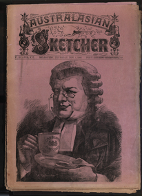
Newspaper, Australasian Sketcher, 30 June 1884 to 01 November 1888, 1883 and 1888
Two copies of the Austakasian Sketcher with Pen and Pencil .1) 30 June 1884 Includes articles on Archbishop Moran, Children's Hospital, Sherbourne Sheppard obituary, the Tichborne case Includes images of the Most Reverand P.F. Moran, Catholic Archbishop of Sydney, New Sandridge Dock, Cricketing news from home, sketches from the Children's Hospital, View of Napier New Zealand, F. Mills New Warehouse Launceston, Grace Park .2) 01 November 1888 Articles include: Australian animals Images include: Cadbury's cocoa advertisement, A Flemington Picture, Railway Surveying Wangaratta to Mansfield, H.M.S. Nelson Leaving Sydney, New Prince's Bridge, Wilson Hall, Victoria before gold, Fawkner's First Printing Office, Government House Melbourne, Sandridge, Hobson's Bay, Old Supreme Court Melbourne, Melbourne Town Hall, Ballarat in the 50, Geelong in 1840, Ballarat Church of Engand Cathedral, Melbourne Exhibition Building, Flemington Racecourse, the Australian Club, Sir Anthony Musgrave, Fisheries Court at the Centennial Exhibition; Professor Neumayer, Antarctic Exploration, Melbourne Town Hall Organmelbourne international exhibition -
 Uniting Church Archives - Synod of Victoria
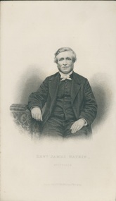
Engraving from photograph, Undated
James Watkin (1805–86), Pioneer Missionary. James Watkin was born in Manchester in 1805. While still young he felt the call to preach and in 1830 was accepted as a candidate for the Wesleyan Ministry. In the same year he married Hannah Entwistle and they sailed with a missionary party to Tonga. The work of the mission was jeopardised by prolonged and involved struggles between Christian and non-Christian Tongan chiefs; Watkin faced alone the danger of tribal warfare, but the experience left him depressed and exhausted. On his removal with his family to Sydney in September 1837 he prayed for a return home to England. Instead, when John Jones offered a free passage for a missionary appointed to Waikouaiti, where Jones had a whaling station, Watkin was selected for the post and arrived there in May 1840. Here he established the first mission station in the South Island. Watkin found the whaling settlement of Waikouaiti a centre of violence, licentiousness, and drunken depravity. Thoroughly disliking the corrupted Maoris and convinced that they were doomed to extinction, and disgusted by the brutality and vices of his fellow Europeans, Watkin laboured without hope, in the bitterness of exile and with deepening depression and distress. In spite of an abhorrence for his situation he established schools at Waikouaiti and Matanaka, and stationed partly trained Maori teachers at Stewart Island and at Moeraki. He had a natural flair for languages, preached in Maori four months after his arrival, and compiled an elementary reading book to be printed in Ngai Tahu. In November 1840 Watkin was greatly disturbed by Bishop Pompallier's visit to Otago. When, however, this was followed by Anglican intrusion – for Bishop Selwyn visited Otago in January 1844 – Watkin thought of withdrawing his own Maori teachers and abandoning the field. Never reconciled to his position at Waikouaiti, Watkin was relieved by Charles Creed and in June 1844 he sailed for Wellington, leaving 227 church members in Otago. In 1855 Watkin settled in New South Wales, and was president of the National Methodist Conference at Adelaide in 1862. He retired in 1869 and died on 14 May 1886, at Ashfield, New South Wales. 'WATKIN, James', from An Encyclopaedia of New Zealand, edited by A. H. McLintock, originally published in 1966. Te Ara - the Encyclopedia of New Zealand URL: http://www.TeAra.govt.nz/en/1966/watkin-james (accessed 30 Apr 2018) B & W engraving from a photograph of the Rev. James Watkin.Revd. James Watkin, Australia Engraved by J. Cochran from a Photograph. -
 Warrnambool and District Historical Society Inc.
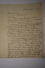
Document, Letter to Mr J H Osborne 1901, 1901
Thomas Hamilton Tracey Osborne was born at Belfast 4/9/1851, the son of Thomas Hamilton Trail Osborne and his second wife Eliza nee Treacey. The young Thomas spent many hours among seamen and ships at Port Fairy. He moved to Warrnambool and commenced work as secretary to the Western Steam Navigation Company becoming manager in 1883. After the company failed he joined with Mark Saltau and they traded as Saltau and Osborne. His other main interest was writing some of which he did under the nom de plume of Sliding Gunter. These articles appeared in The Warrnambool Standard and the Belfast Gazette. He was knowlegable and maintained an interest in shipping and the sea. He died in 11th December 1902 and his body was taken on board the Julia Percy and was buried at sea out from the Breakwater. He was well liked in the district and people lined the Cannon Hill area and the foreshore to farewell him. As an avid writer he corresponded with many people and this letter is one such letter. It relates to recollections of the wreck of the Maria in 1840 out of Adelaide and the loss of life which followed. Unfortunately the letter is incomplete.This letter is of interest as it is addressed to one of Warrnambool's interesting people at the turn of the 20th century. Thomas Hamilton Tracey Osborne has left a legacy of much written work which records aspects of Warrnambool's history as well as his interest in ships and seafaring. This letter shows he drew his information from various sources.One lined page of a letter written in black pen. A wide margin on the left side of the page . The back is blank.The letter is addressed to Mr T H Osborne. Date November 30th 1901.thomas hamilton tracey osborne, western steam navigation company, saltau and osborne, 1901 letter, wreck of the maria 1840 -
 Bendigo Historical Society Inc.
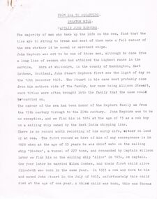
Document - CAPTAIN JOHN HEPBURN: FROM SEA TO SQUATTING
Captain John Hepburn (7 page document re Hepburn by unknown author titled '' From Sea to Squatting - Smeaton Hill. Unknown date). Born Whitekirk Haddington East Lothean Scotland, 10 December 1803. His mother nee Stewart. Worked for East India Shipping Line. In 1828 at 25 years became the mate on the vessel 'Diaden'. Captain Wilson. As Captain of the 'Alice' in 1830 married Eliza Combes. Alice Elizabeth, 1st child, born the same Year. 1833 a son John Stewart was born and unfortunately died one year later. A third child Thomas was born. He sailed on a steam propelled vessel between Sydney and Newcastle. He later took over the ship 'Ceres' and was expected to run the Board of Directors. Sadly health prevailed. The 'Ceres' struck 'Whale Rock' and sank. Captain Martin was in charge at the time. Mr. J. Gardiner offered and overland to Victoria. Other names are; Mrs Coghill, John Coghill,. Strathallen, Smeaton Hill, Fourth child John Stewart born. Benjamin Hepburn, Eliza 1840, Henry 1842, Mary 1845, Helen 1845 (twins), Jane1847, Anne 1849. John Hepburn appointed a Magistrate. Reghetti.person, individual, captain john hepburn, the settlers act, john sturat hepburn, george hepburn, allison stewart, smeaton homestead, thomas, eliza, henry, mary, helen, jane and anne hepburn. mr j. gardiner, loddon district, mrs coghill, john cohill, strathallen run, george stuart coghill, captain willson, eliza combes -
 Flagstaff Hill Maritime Museum and Village
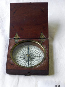
Instrument - Compass, c. 1839
This magnetic compass is a good size to fit easily into a person's pocket or personal luggage and is protected from knocks by its wooden case. It could have been used for reference when travelling on land or sea. There is no visible manufacturer's mark, which may mean that it was not of high monetary value. Leith is a district of Edinburgh in the country of Scotland, the U.K. It was once the Port of Edinburgh and many migrant ships departed from here bound for the Australian colony. It had a busy shipbuilding industry, with wet and dry docks. It appears from the inscription on the case "Chas Gray, LEITH, 1839" that this pocket compass once belonged to Charles M. Gray (Chas is a common abbreviation for the name Charles). The inscription coincides with the name, place and date that the Western Victorian pioneer Charles M. Gray left Scotland and arrived in Australia. Charles Gray was born in Anstruther, Scotland, in 1818. His family was connected with the Royal Marines, which may have created his nautical instruments such as this pocket compass. Charles Gray arrived in Hobson's Bay on 15 June 1839 on the ship “Midlothian”. That same ship had departed from Leith, Scotland on February 15th 1839. Did Charles Gray acquire the pocket compass in Leith, perhaps as a gift or a souvenir of his motherland? Charles Gray was an early squatter and went on to become a very successful settler as a sheep pastoralist in the Western District of what is now Victoria (originally the colony of New South Wales). He and his wife had a large property called “Nareeb Nareeb”, Green Hill Creek District (now Glenthompson), Victoria, from 1840-1886. He was also a local Councillor and Justice of the Peace, and had an interest in the local indigenous people; he named his property after their tribe. Charles returned to England in 1890 and died there in 1905. Charles Gray had written an account in 1890 of his life at Nareeb Nareeb, called Western Victoria in the Forties: "REMINISCENCES OF A PIONEER The Western District in the 1840's By Charles Gray" , a valuable historical reference to colonial Victoria. His book was published by the Hamilton Spectator in 1932. Charles Gray's photograph is one of 713 historical photographs of early Victorian settlers, created as a montage by Thomas Foster Chuck in 1872. The State Library of Victoria holds the framed montage titled “The Explorers and Early Colonists of Victoria”. To qualify for inclusion on this montage the Settlers must have arrived in Victoria before 1843. Charles Gray's photograph is number 349! The pocket compass is associated with Charles Gray, one of the early squatters and settlers in Western Victoria, possibly given to him as a parting gift on his emigration to Van Diemans land in 1839. The item is very significant as it's connection with one of Victoria's early pioneers is well provenanced by the inscriptions on the wooden case. Pocket compass, brass, set into a square wooden case with hinged lid and small hook catch. Compass is marked with 360 degrees and compass points and has two pointers; one to show magnetic north and one to set the direction of travel. Hinges are triangular and inset into the wood. The lid has an attached brass plaque with the inscription "Chas Gray, Leith, 1839" (It likely belonged to Charles Gray, Leith, UK, who migrated to Port Philip Australia in 1839 and became a successful pastoralist.) “Chas Gray / LEITH / 1839” engraved on brass plaque on lid.flagstaff hill, warrnambool, shipwrecked coast, flagstaff hill maritime museum, maritime museum, shipwreck coast, flagstaff hill maritime village, great ocean road, magnetic compass, pocket compass, charles m. gray, chas gray, migrrant from leith 1839, charles gray anstruther, scottland, ship midlothian 1839, squatter western victoria, settler western victoria, hobson's bay port phillip australia, charles gray nareeb nareeb - green hill creek district, western victoria in the forties: reminiscences of a pioneer by charles m. gray 1890, leith edinburgh u.k., western victoria in the forties: reminiscences of a pioneer - montage by thomas foster chuck 1872, charles gray, reminiscences of a pioneer, the western district in the 1840's, compass, scientific instrument, nautical instrument, direction, directional compass, navigation -
 City of Moorabbin Historical Society (Operating the Box Cottage Museum)
Document, laminated photocopy of 'Plan of Moorabbin 1850', 1853
Weston Bate, 'A history of Brighton' 1962 informs us that in 1840 Henry Dendy, who was a farmer in Sussex England, paid 5,120 pounds sterling @ 1pound per acre for a 'Special Survey of Land in Port Phillip , Australia. Henry arrived in Australia in 1841 on the frigate 'York' with his wife, son, and three servants. He also took advantage of the Government Assistance of Free Immigrants for Survey Purchasers, to help on his estate and persuaded some Sussex men with their families to follow him. However when Dendy arrived in Port Phillip he found that LaTrobe and Gipps were trying to raise the price of land close to Town to 15pounds per acre. Dendy asked merchant J.B.Were to manage his affairs and they went ahead with plans to subdivide the surveyed land called 'The Brighton Estate' This area of land extended easterly from the Port Phillip Bay to East Boundary Road and from North Road to South Road in the Parish of Bourke Victoria. The Privy Council, England , decide that Henry Dendy could purchase the land at 1pound per acre. Land Sales proceeded from 1844 as more immigrants established market gardens, farms and varied businesses in 'Moorabbin'This is a photocopy of a Map of the Moorabbin , County of Bourke c1850 showing the 'Henry Dendy Special Survey 1841'A photocopy of a Map of the Moorabbin , County of Bourke c1850. A3 size laminatedLeft corner : MOORABBIN / COUNTY OF / BOURKEdendy henry, dendy special survey 1841, brighton, moorabbin, ormond, bentleigh, market gardeners, pioneers early settlers, box william, box elizabeth -
 Eltham District Historical Society Inc
Negative - Photograph, Bridge on Main Road, Eltham, c.1890
Possibly produced as a postcard. Caption in lower right hand corner reads: Bridge (at) Main Road Eltham. The long wooden suspension bridge over the Diamond Creek on Main Road at Eltham collapsed during flooding of the Diamond Creek on October 13 and 14, 1923. The original bridge was built around 1840 for the coach road when Cobb & Co.'s coach was the only conveyance between Eltham and Melbourne. Widespread damage was done in Melbourne and surrounding areas by floods resulting from the overflow of the Yarra at many points along its banks. A temporary bridge rigged up was severely damaged by the flooding of the creek and was closed to vehicular traffic in April 1924. A new concrete bridge was constructed to replace it and by May 1926 all the concrete piles and abutments had been completed. The bridge was finally completed and opened for traffic in September 1926, almost three years after it initially collapsed. Viewed from Antoinette Boulevard looking northwest towards Falkiner Street. The building in the distance believed to be Souters Cottage. On the far right on the very edge of the road verge are two Eucalypt trees, one of which is believed to be the large dead trunk still standing in present day.This photo forms part of a collection of photographs gathered by the Shire of Eltham for their centenary project book,"Pioneers and Painters: 100 years of the Shire of Eltham" by Alan Marshall (1971). The collection of over 500 images is held in partnership between Eltham District Historical Society and Yarra Plenty Regional Library (Eltham Library) and is now formally known as the 'The Shire of Eltham Pioneers Photograph Collection.' It is significant in being the first community sourced collection representing the places and people of the Shire's first one hundred years.Digital image 4 x 5 inch B&W Neg Black and white print 35mm positive transparencyshire of eltham pioneers photograph collection, eltham, main road bridge, eltham south, bridge, diamond creek (creek), significant tree, souters cottage, eltham lower park, main road, sepp -
 Eltham District Historical Society Inc
Photograph - Photograph postcard, The Rose Stereograph Company, View at Eltham, Vic. Postcard sent from Ernest and family to Joe, 3 May 1936, c.1920
Postcard sent from Ernest and family to Joe, 3 May 1936. Original photo estimated to be circa 1920. Looking west across the original Main Road Bridge and the Diamond Creek from near the intersection of Antoinette Boulevard. To the right of the bridge appear to be orchard trees in flood waters. The long wooden suspension bridge over the Diamond Creek on Main Road at Eltham collapsed during flooding of the Diamond Creek on October 13 and 14, 1923. The original bridge was built around 1840 for the coach road when Cobb & Co.'s coach was the only conveyance between Eltham and Melbourne. Widespread damage was done in Melbourne and surrounding areas by floods resulting from the overflow of the Yarra at many points along its banks. A temporary bridge rigged up was severely damaged by the flooding of the creek and was closed to vehicular traffic in April 1924. A new concrete bridge was constructed to replace it and by May 1926 all the concrete piles and abutments had been completed. The bridge was finally completed and opened for traffic in September 1926, almost three years after it initially collapsed. The Rose Series P. 4346 Postcards scanned from the collection of Michael Aitken on loan to EDHS, 13 Feb 2018Digital file only Postcards scanned from the collection of Michael Aitken on loan to EDHS, 13 Feb 2018michael aitken collection, postcards, main road bridge, main road, eltham, antoinette boulevard, diamond creek (creek), eltham south -
 Ballarat Heritage Services
Photograph - Colour, Dorothy Wickham, St Just, Cronwall, World Heritage Site
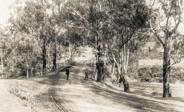
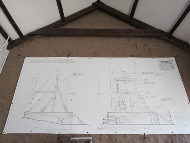
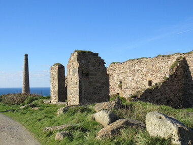
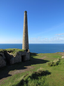
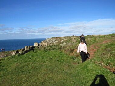
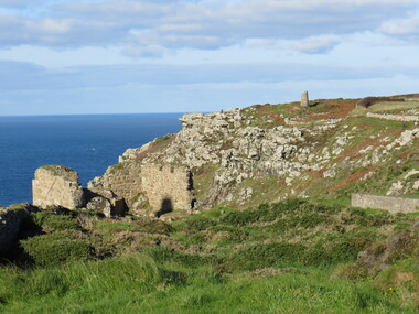
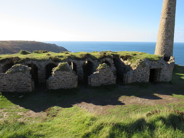
A stone’s throw from Land’s End, this is the most westerly Area of the Site. St Just is characterised by big skies, jagged rocks, stark moorland, and iconic clifftop engine houses perched above the Atlantic in some incredible locations. No wonder this dramatic setting has inspired generations of artists, writers and photographers. World-famous for their mineralogy, the mining sites here are extremely well preserved – as is the sense of community amongst the people whose lives they once dominated. This Area’s unique geography and mineralogy meant that undersea mining was more concentrated here than anywhere else in the world in the 18th and 19th centuries. The oldest surviving Cornish beam engine (constructed in 1840) remains in its original engine house at Levant, restored and still working under steam. Geevor, one of the last mines to close in Cornwall (1990), was saved from demolition and is now the largest metalliferous mine site open to the public in the UK. The historic mining town of St Just is home to characteristic rows of granite mine workers’ cottages, public squares, shops, cafés, art galleries and, just off Bank Square, a medieval grassed amphitheatre – the Plen an Gwary or ‘playing place’.st just, world heritage, ellis, penrose, cornwall, mining, mines -
 Ballarat Heritage Services
Photograph - Colour, Dorothy Wickham, St Just, Cornwall, World Heritage Site
A stone’s throw from Land’s End, this is the most westerly Area of the Site. St Just is characterised by big skies, jagged rocks, stark moorland, and iconic clifftop engine houses perched above the Atlantic in some incredible locations. No wonder this dramatic setting has inspired generations of artists, writers and photographers. World-famous for their mineralogy, the mining sites here are extremely well preserved – as is the sense of community amongst the people whose lives they once dominated. This Area’s unique geography and mineralogy meant that undersea mining was more concentrated here than anywhere else in the world in the 18th and 19th centuries. The oldest surviving Cornish beam engine (constructed in 1840) remains in its original engine house at Levant, restored and still working under steam. Geevor, one of the last mines to close in Cornwall (1990), was saved from demolition and is now the largest metalliferous mine site open to the public in the UK. The historic mining town of St Just is home to characteristic rows of granite mine workers’ cottages, public squares, shops, cafés, art galleries and, just off Bank Square, a medieval grassed amphitheatre – the Plen an Gwary or ‘playing place’.st just, world heritage,, ellis,, penrose, cornwall, mining, mines -
 Ballarat Heritage Services
Photograph - Colour, Dorothy Wickham, St Just, Cornwall, World Heritage Site
A stone’s throw from Land’s End, this is the most westerly Area of the Site. St Just is characterised by big skies, jagged rocks, stark moorland, and iconic clifftop engine houses perched above the Atlantic in some incredible locations. No wonder this dramatic setting has inspired generations of artists, writers and photographers. World-famous for their mineralogy, the mining sites here are extremely well preserved – as is the sense of community amongst the people whose lives they once dominated. This Area’s unique geography and mineralogy meant that undersea mining was more concentrated here than anywhere else in the world in the 18th and 19th centuries. The oldest surviving Cornish beam engine (constructed in 1840) remains in its original engine house at Levant, restored and still working under steam. Geevor, one of the last mines to close in Cornwall (1990), was saved from demolition and is now the largest metalliferous mine site open to the public in the UK. The historic mining town of St Just is home to characteristic rows of granite mine workers’ cottages, public squares, shops, cafés, art galleries and, just off Bank Square, a medieval grassed amphitheatre – the Plen an Gwary or ‘playing place’.st just, world heritage, ellis, penrose, cornwall, mining, mines -
 Ballarat Heritage Services
Photograph - Colour, Dorothy Wickham, St Just, Cronwall, World Heritage Site
A stone’s throw from Land’s End, this is the most westerly Area of the Site. St Just is characterised by big skies, jagged rocks, stark moorland, and iconic clifftop engine houses perched above the Atlantic in some incredible locations. No wonder this dramatic setting has inspired generations of artists, writers and photographers. World-famous for their mineralogy, the mining sites here are extremely well preserved – as is the sense of community amongst the people whose lives they once dominated. This Area’s unique geography and mineralogy meant that undersea mining was more concentrated here than anywhere else in the world in the 18th and 19th centuries. The oldest surviving Cornish beam engine (constructed in 1840) remains in its original engine house at Levant, restored and still working under steam. Geevor, one of the last mines to close in Cornwall (1990), was saved from demolition and is now the largest metalliferous mine site open to the public in the UK. The historic mining town of St Just is home to characteristic rows of granite mine workers’ cottages, public squares, shops, cafés, art galleries and, just off Bank Square, a medieval grassed amphitheatre – the Plen an Gwary or ‘playing place’.st just, world heritage, ellis, penrose, cornwall, mining, mines -
 Ballarat Heritage Services
Photograph - Colour, Dorothy Wickham, St Just, Cornwall, World Heritage Site
A stone’s throw from Land’s End, this is the most westerly Area of the Site. St Just is characterised by big skies, jagged rocks, stark moorland, and iconic clifftop engine houses perched above the Atlantic in some incredible locations. No wonder this dramatic setting has inspired generations of artists, writers and photographers. World-famous for their mineralogy, the mining sites here are extremely well preserved – as is the sense of community amongst the people whose lives they once dominated. This Area’s unique geography and mineralogy meant that undersea mining was more concentrated here than anywhere else in the world in the 18th and 19th centuries. The oldest surviving Cornish beam engine (constructed in 1840) remains in its original engine house at Levant, restored and still working under steam. Geevor, one of the last mines to close in Cornwall (1990), was saved from demolition and is now the largest metalliferous mine site open to the public in the UK. The historic mining town of St Just is home to characteristic rows of granite mine workers’ cottages, public squares, shops, cafés, art galleries and, just off Bank Square, a medieval grassed amphitheatre – the Plen an Gwary or ‘playing place’.st just, world heritage, ellis, penrose, cornwall, mining, mines -
 Ballarat Heritage Services
Photograph - Colour, Dorothy Wickham, St Just, Cornwall, World Heritage Site
A stone’s throw from Land’s End, this is the most westerly Area of the Site. St Just is characterised by big skies, jagged rocks, stark moorland, and iconic clifftop engine houses perched above the Atlantic in some incredible locations. No wonder this dramatic setting has inspired generations of artists, writers and photographers. World-famous for their mineralogy, the mining sites here are extremely well preserved – as is the sense of community amongst the people whose lives they once dominated. This Area’s unique geography and mineralogy meant that undersea mining was more concentrated here than anywhere else in the world in the 18th and 19th centuries. The oldest surviving Cornish beam engine (constructed in 1840) remains in its original engine house at Levant, restored and still working under steam. Geevor, one of the last mines to close in Cornwall (1990), was saved from demolition and is now the largest metalliferous mine site open to the public in the UK. The historic mining town of St Just is home to characteristic rows of granite mine workers’ cottages, public squares, shops, cafés, art galleries and, just off Bank Square, a medieval grassed amphitheatre – the Plen an Gwary or ‘playing place’.st just, world heritage, ellis, penrose, cornwall, mining, mines -
 Eltham District Historical Society Inc
Book - Cook Book, Mary Rundell, A New System of Domestic Cookery; formed upon principles of economy and adapted to the use of private families. With Ten Illustrations. By a Lady, 1849
First published in 1806 by John Murray and written by Maria Rundell, later editions were "By a Lady". https://en.wikipedia.org/wiki/A_New_System_of_Domestic_Cookery A legal dispute arose between Murray and Rundell over the copyright of the cookery book titled "A New System of Domestic Cookery" by Mary Eliza Rundell. The book, which was published in 1806, gained immense popularity over the years. In 1821, Murray claimed that Rundell had infringed on his copyright by publishing a new edition of the book without his permission. The case was brought to court, and after much debate, it was ruled that Rundell had indeed infringed on Murray's copyright. The court ordered her to pay damages and to stop publishing the book without Murray's consent. This ruling was significant as it established the legal precedent that copyright law applied to books and other written works. - Based on an article from The Edinburgh Annual Register, 1821 Robert William Whatmough (1815 Heywood, Lancashire-1887 Diamond Creek, Victoria) and his wife Mary Hill ( 1813 Rochdale, Lancashire - 1881 Greensborough, Victoria) were pioneer settlers on the Plenty River at Greensborough. Their daughter, Jemima Whatmough (1840-1926) married Robert Fielding (1820-1891) who were the parents of Thomas Edmund Fielding and great grandparents of Tom FieldingInscribed inside front leaf facing page in ink: Robert Whatmough Plenty River 1858tom fielding collection -
 Phillip Island and District Historical Society Inc.
Photograph - Photograph, black + white, c. 1900
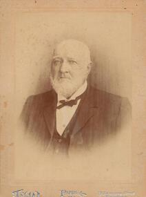
John Cleeland JP of Newhaven, 1826-1914, a native of County Down, Ireland, came to Victoria in 1840 with his parents and settled at Darebin Creek. After a few years spent there he went to sea in his schooner yacht of 200 tons, the Harriet, visiting the South Sea Islands and the west coast of South America. In 1859 he took the well known Albion Hotel, Bourke-street east, Melbourne, the starting place for all Cobb and Co's lines of up-country coaches, and kept it for 22 years, marrying whilst there Miss Blake, of Mornington. Shortly before leaving the hotel he purchased 7000 acres of land at Phillip Island for breeding purposes, and there bred Wollomai, who won the Melbourne Cup in 1875. In 1881 he retired to his magnificent estate, besides which he has another 1000 acres at Bass and other properties. He also once owned racing stables at Brighton, where he had Barwon (which won the Champion race) and other valuable horses. Mr Cleeland is a member of the Phillip Island Council and is a justice of the peace for the central bailiwick. Taken from Victoria and its Metropolis: past and present, 1888. Donated by Ivy Cleeland, John Cleeland's grand-daughter.Portrait of John Cleeland of Wollomai House, Phillip Island.On front: Paris, 119 Swanston Street, Melbourne On back: John Cleeland of Wollomai House.john cleeland, ivy cleeland -
 National Wool Museum
Tool - Shearing Handpiece, c.1890
Ford and McFarlane shearing handpiece c.1890. This shearing handpiece is from ‘Wellington Lodge” in Tailem Bend, South Australia. Wellington Lodge today is an Angus beef farm; however, the property has a long history which includes wool farming. Wellington Lodge has been in the McFarlane family since the 1840’s and was originally around 19000 acres. The donor, Brian Licence, assembled this handpiece out of spare parts he found while classing wool on the property in the 1960s. Brian showed the finished handpiece to the owners once his classing work was completed and was told he could keep the handpiece as a souvenir. Brian also classed wool at “Jockwar” and “Pleasant Park” in Penola for members of the McFarlane family during the 1960s. The handpiece is named after Ford, the name of the engineer who designed the handpiece and McFarlane, the owners of Wellington Lodge Station and employers of Ford. This handpiece was developed as a prototype for use on the property. The handpiece which is made of solid brass is in a “used condition” and has been patched with solder. The handpiece is stamped with the number 10. Internally, the handpiece is powered from a drive mechanism of compressed air, this compressed air was typically produced by burning mutton fat. The handpiece comes from the pre-electrical– steam engine era of shearing. Brass metal shearing handpiece. A three-pronged fitting to hold both the comb and the blade protrudes from one end. A cylindrical stem extends vertically from the other. This is likely where a connecting rod to the shearing plant would be found. Below this vertical stem, the handpiece has an additional threaded hose fitting. This is likely where compressed air was delivered into the handpiece. The inscriptions can be found on the rear, near the previously mentioned vertical stem. Around this stem is also where the repairs of solder can be found. These repairs are unique to this handpiece and are not common practise.Etched. Base of handle. “FORD & McFARLANE . SHEEP SHEARER . Etched. Base of handle. “10”sheep shearing, shearing equipment, ford & mcfarlane, wellington lodge, tailem bend, south australia, shearing handpiece, shearing -
 Flagstaff Hill Maritime Museum and Village
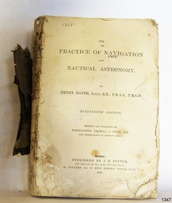
Book - Technical Reference, Henry Raper, Lieut. R.N, The Practice of Navigation and Nautical Astronomy, 1891
This technical textbook is the nineteenth edition of the book by Henry Raper, Lieutenant in the Royal Navy with awards that include F.R.A.S. (Fellow of the Royal Astronomical Society) and F.R.G.S. (Friend of the Royal Geographical Society). The book is dedicated in honour of Rear-Admiral Sir Francis Beaufort K.C.B., Hydrographer to the Admiralty. He was awarded the title K.C.B. (King's Commander) as a Member of the Order of Bath, an order of British Chivalry, The book was first published in 1840 and soon became a resource for navigation students. It includes topics on nautical navigation, astronomy, navigation charts, calculations and mathematical tables, time, tides, ships, longitude, and position at sea. Thomas A. Hull, who revised and expanded this edition, was a Commander in the Royal Navy and had previously been Superintendent of Admiralty Charts used for navigation worldwide by seamen from many walks of life. The publisher, J D Potter of London, was at that time the sole agent for the Admiralty Charts produced by the Royal Navy. Printer Spottswoode and Co.,. was established by William Strachan in 1738. In 1819 his nephews A and R Spottswoode took over the business and bought premises in New-Street Square and Shoe Lane. In 1850 over 200 workers were employed by the firm. and five years later the business became Spottswoode & Co. Andrew Spottswoode invented the Spottswoode Press.This technical book was very popular as a textbook for students of maritime navigation, written and updated by members of the British Royal Navy and relied upon for accurate advice and information. The first edition was published in 1840, this edition was updated, expanded and published in 1891 when ports around the world were filling with travellers, merchants and business people. Title: The Practice of Navigation and Nautical Astronomy Author: Henry Raper, Lieut, R.N., F.R.A.S., F.R.G.S. Nineteenth Edition, revised and enlarged by Commander Thomas A. Hull, R.N., Late Superintendant of Admiralty Charts Dedication: To Rear-Admiral Sir Francis Beaufort K.C.B. Publisher: J D Potter, London, sole agent for the sale of Admiralty Charts Printer: Spottswoode and Co. New-Street Square, London Date: 1891 Small leather hardcover book with gold embossed text and lines on the spine. The Dedication in the book is as follows: - "To Rear-Admiral Sir Francis Beaufort K.C.B. Hydrographer to the Admiralty. Sir, The eminent station which you occupy in the naval scientific world renders it highly gratifying to me to dedicate the following Work to you as a testimony of my regard and esteem; while the general accordance of my views on the subject with those of your more experienced judgement, gives me the greater confidence in laying my labours before the Public. I have the honour to be, Sir, Your obedient servant, HENRY RAPER"flagstaff hill maritime museum, maritime museum, shipwreck coast, flagstaff hill, warrnambool, flagstaff hill maritime village, book, navigation, nautical astronomy, hydrography, nautical charts, nautical navigation, astronomical navigation, admiralty charts, henry raper, thomas a. hull, royal navy, j d potter, royal astronomical society, royal geographical society, calculations, mathematical tables, longitude, latitude, nautical time, location at sea, position at sea, maritime, practical navigation, spottswoode and co., sir francis beaufort, k.c.b., rear-admiral sir francis beaufort, hydrographer to the admiralty, scientific book, naval science