Showing 16556 items
matching 1956-07-26
-
 Ballarat Tramway Museum
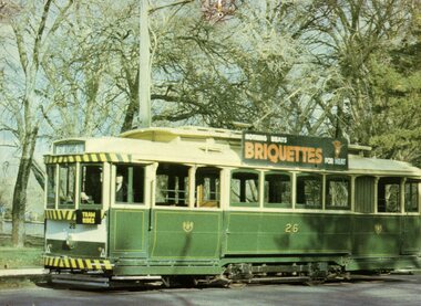
Postcard, Bascands Ltd. Christchurch NZ, SECV 26
Colour postcard of SECV Ballarat No. 26, photographed in Wendouree Parade during possibly late 1975 by W.J.Kingsley for the BTPS postcard. Tram has St Aidans Drive destination and "TRAM RIDES" signs. Tram in SECV livery. Has "Nothing Beats Briquettes for heat" advertising board on side. On rear is a note regarding the tram, the BTPS and its operations, printers name and photographers name, with place for stamp and address. trams, tramways, wendouree parade, btps, postcards -
 Anglesea and District Historical Society
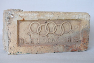
Olympic Brick 1956, 1956
This is a soft mud sand-stock moulded or semi-dry pressed brick bearing the 5 Olympic rings with the words "GLEN 1956 IRIS" across the bottom.5 Olympic Rings "GLEN 1956 IRIS"olympics 1956, glen iris brick works -
 Vision Australia
Audio (item) - Sound recording, Royal Victorian Institute for the Blind, Around the Institute: February 26, 2002
Around the Institute was a weekly program designed to keep clients and staff informed of events, activities and thoughts relating to low vision and blindness. It consisted of interviews undertaken by Jo Matthews-Lamb, Susan Thompson, Janet Cronin and Corey Nassau, with sound engineer Ed Gamble, designed to inform, educate and explore on a variety of topics. February 26: Auxiliaries and the future - Sue Parks, Street furniture policy introduced in Boroondara - Pat Peck. royal victorian institute for the blind, radio shows -
 Invermay Local History Association
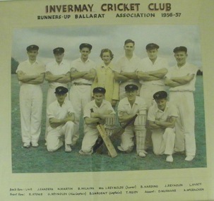
Photograph (Framed), Invermay Cricket Club: Runners-up Ballarat Association 1956-57, c.1957
This framed photo usually hangs on the wall of the meeting room at the Invermay Hall, on the Invermay Reserve. The photograph features Invermay Cricket Club member Tom Reidy who donated his Cricket Club jacket to the Invermay Local History Assn. This jacket is now held in the ILHA Collection.The photograph is of historical and cultural significance. This is the only known copy of the photograph. It records an important aspect of the Invermay community's sporting history from the 1950s. White timber frame. Hardboard backing board held in place with 3 small nails and framing tacks. Hand coloured photograph glued to ivory cardboard mount. Clear glass over.'Invermay Cricket Club / Runners-up Ballarat Association 1956-57 / Back Row: (L to R) J. Sanders, N. Martin, B. Wilkins, Mrs L. Reynolds (Scorer), B. Harding, J. Reynolds, L. Hyatt / Front Row: R. Stowe, G. Reynolds (Vice Captain), B. Sargent (Captain), T. Reidy, Absent: D. Murnae, A. McCrackeninvermay cricket club, sanders, martin, wilkins, reynolds, harding, hyatt, stowe, sargent, reidy, murnane, mccracken, -
Vision Australia
Audio (item) - Sound recording, Royal Victorian Institute for the Blind, Around the Institute: March 26, 2002
Around the Institute was a weekly program designed to keep clients and staff informed of events, activities and thoughts relating to low vision and blindness. It consisted of interviews undertaken by Jo Matthews-Lamb, Susan Thompson, Janet Cronin and Corey Nassau, with sound engineer Ed Gamble, designed to inform, educate and explore on a variety of topics. March 26: Training and technology - Dale Moore, Adaptive technology obtained since winning a Bursary Award - Hamish McKenzie.royal victorian institute for the blind, radio shows -
Vision Australia
Audio (item) - Sound recording, Royal Victorian Institute for the Blind, Around the Institute: November 26, 2002
Around the Institute was a weekly program designed to keep clients and staff informed of events, activities and thoughts relating to low vision and blindness. It consisted of interviews undertaken by Jo Matthews-Lamb, Susan Thompson, Janet Cronin and Corey Nassau, with sound engineer Ed Gamble, designed to inform, educate and explore on a variety of topics. November 26: Further Education Bursary grant - Dean Calder, Client Advisory Special Interest Group - Peter O’Connor. royal victorian institute for the blind, radio shows -
 Ballarat Tramway Museum
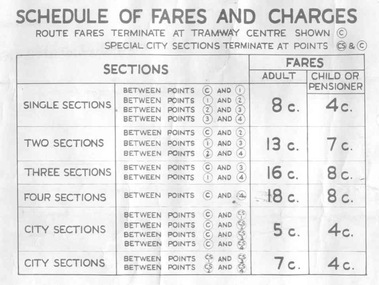
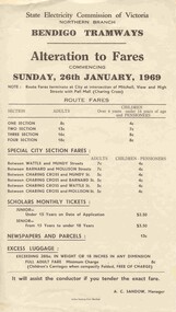
Poster, State Electricity Commission of Victoria (SECV), "Schedule of Fares and Charges - 26/1/1969", Jan. 1969
Demonstrates the way the SEC advised passengers in Ballarat and Bendigo how the fare and charges systems worked and yielded information about the fare charges in force at the time. A copy was provided in each tram behind framed glass.Dye line print of a drawing showing Bendigo Tramways (SEC) Fares, Charges, and Section Map. Drawing No. VX1/130/1 Also gives charges for Scholar's Monthly tickets, Luggage, Parcels, Newspapers and Chartered trams. Dated January 1969. Titled - "Schedule of Fares and Charges - 26 January 1969". Shows offices as Dispensary Walk. For map - see bgofsmap.jpg and for actual fare tables, btm1734i1.jpg and btm1734i2.jpg."BTPS" in blue ink on reartrams, tramways, bendigo, fares, sections, map -
 Ballarat Tramway Museum
Document - Photocopy, State Electricity Commission of Victoria (SECV), "Bendigo Tramways Alteration to Fares commencing Sunday, 26 January 1969", Jan. 1969
Photocopy of original form, titled "Bendigo Tramways Alteration to Fares commencing Sunday, 26 January 1969", giving new fares schedule for Adults, Children, up to 18c for four sections, special city section fares, scholars monthly tickets, newspapers, parcels and excess luggage. Signed by A.C.Sandow as Manager and printed by Arthur Hocking Print, Bendigo. Original copy of sign provided to Bendigo Tramways. See Donation note. trams, tramways, signs, fares, bendigo -
 Melbourne Tram Museum
Pamphlet, Yarra Trams, "Formula 1 Grand Prix Tram Services Changes Saturday 25 to Sunday 26 March 2017", Feb. 2017
Pamphlet - 6 fold DL from an A3 full colour sheet titled "Formula 1 Grand Prix Tram Services Changes Saturday 25 to Sunday 26 March 2017" printed for public distribution. Gives information on tram route changes, contact details, how to get to Albert Park, circuit map and service frequency. Produced by PTV, Yarra Trams and Victorian State Government - has their logos on the sheet.trams, tramways, yarra trams, grand prix, map, public transport -
 Ringwood and District Historical Society
Map - State Aerial Survey, Dandenong Ranges Area, Parishes of Warrandyte and Ringwood - 1956
Map of central and southern areas of Ringwood and part of Ringwood East and Heathmont compiled by Dept of Lands and Survey, July 1956, from aerial photographs and Cadastral Survey information. Subsequent hand-drawn addition of streets showing layout of "Township of Ballyduffy Estate 1858-60", an earlier proposed subdivision that did not eventuate. (See attached 5009b Ballyshanassy_ Melbourne’s lost suburb.pdf for Ballyduffy historical naming relevance). Ballyduffy Estate streets include City Road, West Prussia Road, Duffy Street, Ireland Street, Evans Street, Victoria Street, Regina Street, Short Road, Prussia Road, Duffy Street East, Ireland Street East, Evans Street East, Chapman Street. Misc Topo 93 Sheet 22, Ringwood A4B2. Scale: 4 chains to 1 inch. Contour interval 20 feet. -
 Eltham District Historical Society Inc
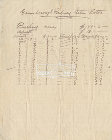
Document - Folder, Greensborough Railway Station Estate, Lots 26, 26A and 26B, Crown Portion 3, Parish of Nillumbik, County of Evelyn (Rattray Road, Montmorency)
Crown Portion 3 of Eltham, Parish of Nillumbik, County of Evelyn, Lots 26, 26A and 26B were part of the Greensborough Railway Station Estate. The land detailed is bounded by present-day Rattray Road, Reichelt Avenue, Wooded Way and Ryrie Court, Montmorency. Originally purchased in September 1913 by George William Miller, signwriter of Greensborough and Harry Frederick Miller, the land was sold to Mrs Margaret Barr Honeyman, 24 June 1918 on mortgage for £400, deposit paid £150. In February 1920, Mr Honeyman called for the title and paid off the loan early, settlement occuring 11 October 1920. Contents: 1. Handwritten payment plan (Sep 1913 to Mar 1923) for Lots 26, 26A and 26B being parts of Crown Portion 3, Parish of Nillumbik, County of Evelyn on the plan of subdivision making up the Greensborough Railway Station Estate situated on Rattray Road; purchased for £179.2.0 with a deposit of £18.0.0. 2. Receipt: From Messrs G.W. and H.F. Miller for £11.15.8 being instalment and interest, 9 Sep 1913 3. Invoice: To Messrs G.W. and H.F. Miller for £11.12.0 being instalment and interest due 15 Sep 1914 4. Contract of Sale: George William Miller and Harry Frederick Miller to Mrs. Margaret Barr Honeyman, in respect of sale of Lots 26, 26A and 26B for £400.0.0, 24 June 1918. Deposit of £150.0.0 balance to be paid half yearly instalments of £15 with interest at 5% per annum added. 5. Letter: Percy J. Russell, Solicitor to G.W. Miller, 5 Feb 1920 advising Mr Honeyman has called for the title and wishes to pay off mortgage. 6. Letter: Percy J. Russell, Solicitor to G.W. Miller, 11 Oct 1920 advising settlement and payment of Miller to Honeyman.contract of sale, george william miller, greensborough railway station estate, harry frederick miller, land sale, margaret barr honeyman, montmorency, rattray road, reichelt avenue, ryrie court, wooded way -
 City of Ballarat Libraries
35mm Slide, Miss Carol Penrose, Queen of Begonias (back) Ballarat Begonia Festival, circa 1956
This slide shows the 1956 "Queen of Begonias" in Ballarat, on her float during the Begonia Festival street parade. Miss Carol Penrose, who was crowned by the Prime Minister Robert Menzies, is shown in the background. The runners up that year were Janet Saunders and Hillary Richards, otherwise known as "Princesses", one being pictured here, in front of the Begonia Queen. Mrs Bon Strange and her husband Bert were well known Ballarat residents. When Mrs Strange died some years ago, her extensive slide collection was sorted through and those relevant to Ballarat were gifted to the Ballarat Library.begonia festival, festival, queen of begonias, ballarat, parade -
Clunes Museum
Badge, 1956
METAL PIN CELEBRATING THE 1956 OLYMPIC GAMES HELD IN MELBOURNE.MEDAL OF LIGHT MATERIAL PROBABLY OF TIN - MALE FIGURE WITH RED TOP WHITE SHORTS RUNNING. BLUE BACKGROUND, YELLOW SURROUND OLYMPIC RINGS AT BASE. SOCCER BALL.OLYMPIC GAMES 1956local history, numismatic, commemorative, medals, badges -
 National Wool Museum
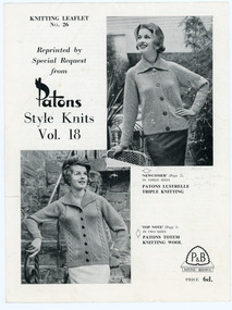
Book, Knitting, Patons Knitting Leaflet no. 26
This knitting pattern leaflet was produced by Patons and Baldwins and contains two patterns for womens cardigans.KNITTING LEAFLET / No. 26 / Reprinted by / Special Request / from / Patons / Style Knits / Vol. 18 / 'NEWCOMER' (Page 2). / IN THREE SIZES / PATONS LUSTRELLE / TRIPLE KNITTING / 'TOP NOTE' (Page 3) / IN TWO SIZES / PATONS TOTEM / KNITTING WOOL / P&B / PAThandicrafts - history knitting, patons and baldwins (australia) ltd, handicrafts - history, knitting -
 City of Ballarat Libraries
35mm Slide, Olympic Games Decorations, Post Office Building, Ballarat 1956
The first section of the Ballarat Post Office was built in 1864, the second (including the tower and offices in Lydiard St) in 1885. The original design had the arched windows on the ground floor (facing Sturt St) forming a colonnade, but these were soon filled in to provide more internal space. Here the Post Office is decorated for the 1956 Olympic Games, when the rowing and canoeing events were held on Lake Wendouree. Mrs Bon Strange and her husband Bert were well known Ballarat residents. When Mrs Strange died some years ago, her extensive slide collection was sorted through and those relevant to Ballarat were gifted to the Ballarat Library. post office building, olympic games, lydiard street north, sturt street, federation university, illuminations -
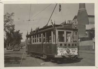 Ballarat Tramway Museum
Photograph - Black & White Photograph/s - set of 3', Keith Kings, 26/03/1956 12:00:00 AM
Black and White print contained within the Wal Jack Bendigo and Geelong Album, see Reg Item 5003 for more details. Set of three black and white photographs from Keith Kings of the staged closures of the Geelong tramways. .1 - Geelong No. 4 - decorated as the Last tram, has a dash sign "Geelong Tramways No. 4 first car 1912, Last car 1956 Farewell", with the destination of Belmont. Photographed with power station in the background in Corio Terrace. 26/3/1956, KSK Photo (T)(e)(8). Printed on Ilford Paper. See also Reg Item 2667 and 4388 for a colour slide version of the same photograph. .2 - ditto - about to leave the depot - KSK Photo - T(g)(3) .3 - ditto - back at the depot - KSK Photo - T(g)(8)On the rear in ink and with the Keith Kings Copyright stamp: .1 - "Geelong - 4 - decorated as Official "Last" tram -26/3/56" - (T)(e)(8). .2 - "Geelong - 4 - illuminated as last tram Sun 26/3/56" - (T)(g)(3). .3 - "Geelong - 4 - last tram, back at Depot, Sun 26/3/56" - (T)(g)(8). trams, tramways, geelong, closure, depot, last tram, tram 4 -
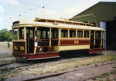 Ballarat Tramway Museum
Functional Object - Tramcar, Duncan and Fraser, SECV Tram No. 26, 1916
Single truck, (4 wheel), drop end California Combination tramcar, reconstructed to as built Condition, cross bench seats in drop ends, longitudinal seats in centre saloon, 2 sliding doors internally, air braked. See Destination City, Destination Eaglehawk Fares Please 1978 to 1987 for conversion back to California combination tram. Trolley Wire Aug 1984 re car mileages for 26, 27 and 28 Trolley Wire Feb. 1988 for article re conversiontrams, tram 26 -
 Ballarat Tramway Museum
Document - Instruction, Ballarat Tramway Preservation Society (BTPS), "Saturday, September 26, 1992. Replica SECV Service ETC.", 25/09/1992 12:00:00 AM
Demonstrates and provides information on how the BTPS celebrated the 21st closing of the SECV operated tramways in Ballarat. Gives details of the days events and who did what. Gives special instructions for crews how to operate the tramcars.A4 size sheet, photocopied both sides titled "Saturday, September 26, 1992. Replica SECV Service ETC." for the 21st celebration of the closure of the Ballarat Tramway system by the BTPS. Gives details of the Officers in Charge, replica SEC service - including changing ends (trolley pole) at night on a single trucker, colour-in-competition, cavalcade of trams and vintage motor cars, TMSV charter and the roster for the day. Gives instructions about driving and the use of power in the cavalcade. Two copies held.Has some changes to tram car numbers in ink on the rear sheet.trams, tramways, 21st anniversary, btps, tmsv, cavalcade -
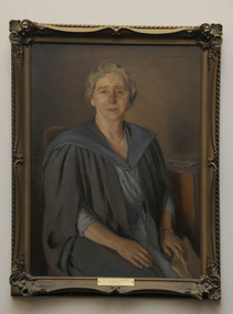 Lauriston Girls’ School (incorporating Lauriston Museum and Gallery)
Painting, Portrait of Miss Elizabeth Kirkhope Headmistress 1901-1933
Painted by Robert Hoffman, a refugee who came to Australia prior to World War II. He was known to Mavis McCarty, the Lauriston art teacher. He went to the USA after the war and died soon after. Size 1100mm x 840mm. This portrait is part of the Record Series 74. Permanent/Semi-Permanent Displayed Works.Oil Painting of Miss Elizabeth Kirkhope Headmistress 1931-1956Miss Elizabeth Kirkhope Headmistress 1931-1956 -
 Eltham District Historical Society Inc
Photograph, Spring Excursion, Hume and Hovell bus tour Stage 2, Seymour, Benalla; 26 Oct 1997, 26/10/1997
MONUMENT HUNTING THE HUME AND HOVELL WAY (Newsletter No. 117, November 1997, by Diana Bassett-Smith) Sunday October 26 1997 dawned bright and very warm. Some twenty-five members, complete with picnic baskets, met outside the Eltham Library awaiting the Cobb and Co. large coach which would be taking us on the second leg of our travels along the route of the early explorers Hume and Hovell. Stephen West was our very good driver for the day. He would be guided around the circuitous route by Russell Yeoman wh9 had made a detailed study, not only of the intended route, but of the story of these two explorers. During the trip Russell regaled us with poetry, quotations from the Journals and the History of the Shire of Seymour, "The New Crossing Place: by Martindale, 1982, (now Mitchell Shire due to the recent amalgamations). We headed towards the Hume Highway via Greensborough and Cooper Street and proceeded north to our first stop, noting on the way Monument Hill in the distance which is near Kilmore and, according to Russell, well worth the effort to visit as the view across the valley is magnificent. Past Sunday Creek Valley, Mt Piper and Mt Disappointment, all traversed and noted and named by them. We passed through Tallarook, then onto Seymour where we took photos of the monument telling us that Hume and Hovell had passed through on the 28th of October 1824. We also deviated down Hume and Hovell Road viewing deer and emu farming and the Bellbourie property now a sanctuary. Leaving Seymour behind we travelled up the Avenel Road to the Avenel monument, pyramidal in design of four reducing square blocks with a sharply pointed peak, erected in 1924 in memory of the 1824 exploration. The day was warming up and the countryside showing the dryness of the current drought. A parallel note had been made in their journal too of 1824 of the drought appearance of the country they were traversing. At Seven Creeks, Euroa we stopped for some minutes to check the monument placed 20th November 1924 to commemorate their passage on the 29th December 1824. More photos. Russell had pointed out the abrupt termination of the distant ranges which is noted in their journal. The next monument is beside the road at the entrance to Honey Suckle Creek Caravan Park, Violet Town. The squarish shaped monument some eight feet high is topped with a simple steel cross, and was to mark the date of 28th December 1824 and built for the 20th November 1924. By now it was 12.20 and nearly lunchtime as we drove along the Warranbayne Road to Roach's Road, monument hunting without success. Though there is a large, what appears to be an old timber sign which was hard to read, maybe this was the lost monument. In many of the paddocks hay had been cut and baled or was being cut, what a contrast to the rugged country they had passed through which was smoky from the fires of the natives burning off By 1.00 pm we were at Benalla and pulled up beside the park where abundant beds of roses filled the air with their scent and the smell of barbecued food twitched the nostrils whilst the cheerful sounds of other picnickers could be heard throughout the park. We left the bus and collected up our picnics, dispersed to the various tables and enjoyed the shade from the various European trees. 2.00 pm and we were on the road again driving along the Benalla, Mansfield, Yea road. The Swanpool monument states that they passed four miles south and returned three miles north. Then we stopped at the Barjarg monument which notes that they camped near this spot. It is again a pyramidal monument and this time topped with a steel arrow indicating their route of the 29th November 1824. Half an hour later we came to another monument, again with a steel arrow marker on top and the plaque dated the 2nd of 12th 1824. Erected on the 12th of 12th 1924. "They blazed the way that we might inherit the land." Another square based and needle topped monument appeared at Yarck near Yea and this plaque records the date of 3 December 1824. Near McGuigans Road Russell related that the expedition had lost a dog but it had found them next day, the dog was apparently torn by a kangaroo. A short while later Russell reminded us here of the problems they encountered in crossing the Goulburn River near Molesworth where banks were high, water deep and wide. "Good coat of grass but quite dry due to drought". At Yea we stopped for afternoon tea and raided the last of our picnics and looked at the monument to their journey of 1824, situated at a corner of the gardens near the bowling green. No photo – we were out of film. We returned home via Kinglake West and Whittlesea past the Yan Yean Reservoir, not full. 5.00 pm back at Eltham we emptied out of the bus and everyone, including Joan Cole, collected their things, Joan also had the major souvenir of the day, a large carp she had picked up from the river bank, her cat was in for a great feast. The day was made so interesting by the informed commentary which Russell provided. His background knowledge of the route and nature of the journey could only have come from many hours of reading and driving the area. Thank you to Russell and to everyone who made the day so informative and pleasurable. Diana Bassett-Smith. Record of the Society's history of activities - Spring 1997 excursionRoll of 35mm colour negative film, 6 stripsFuji 200shire of eltham historical society, activities, pretty hill, seymour, benalla, hume and hovell, monuments -
 Eltham District Historical Society Inc
Photograph, Spring Excursion, Hume and Hovell bus tour Stage 2, Seymour, Benalla; 26 Oct 1997, 26/10/1997
MONUMENT HUNTING THE HUME AND HOVELL WAY (Newsletter No. 117, November 1997, by Diana Bassett-Smith) Sunday October 26 1997 dawned bright and very warm. Some twenty-five members, complete with picnic baskets, met outside the Eltham Library awaiting the Cobb and Co. large coach which would be taking us on the second leg of our travels along the route of the early explorers Hume and Hovell. Stephen West was our very good driver for the day. He would be guided around the circuitous route by Russell Yeoman wh9 had made a detailed study, not only of the intended route, but of the story of these two explorers. During the trip Russell regaled us with poetry, quotations from the Journals and the History of the Shire of Seymour, "The New Crossing Place: by Martindale, 1982, (now Mitchell Shire due to the recent amalgamations). We headed towards the Hume Highway via Greensborough and Cooper Street and proceeded north to our first stop, noting on the way Monument Hill in the distance which is near Kilmore and, according to Russell, well worth the effort to visit as the view across the valley is magnificent. Past Sunday Creek Valley, Mt Piper and Mt Disappointment, all traversed and noted and named by them. We passed through Tallarook, then onto Seymour where we took photos of the monument telling us that Hume and Hovell had passed through on the 28th of October 1824. We also deviated down Hume and Hovell Road viewing deer and emu farming and the Bellbourie property now a sanctuary. Leaving Seymour behind we travelled up the Avenel Road to the Avenel monument, pyramidal in design of four reducing square blocks with a sharply pointed peak, erected in 1924 in memory of the 1824 exploration. The day was warming up and the countryside showing the dryness of the current drought. A parallel note had been made in their journal too of 1824 of the drought appearance of the country they were traversing. At Seven Creeks, Euroa we stopped for some minutes to check the monument placed 20th November 1924 to commemorate their passage on the 29th December 1824. More photos. Russell had pointed out the abrupt termination of the distant ranges which is noted in their journal. The next monument is beside the road at the entrance to Honey Suckle Creek Caravan Park, Violet Town. The squarish shaped monument some eight feet high is topped with a simple steel cross, and was to mark the date of 28th December 1824 and built for the 20th November 1924. By now it was 12.20 and nearly lunchtime as we drove along the Warranbayne Road to Roach's Road, monument hunting without success. Though there is a large, what appears to be an old timber sign which was hard to read, maybe this was the lost monument. In many of the paddocks hay had been cut and baled or was being cut, what a contrast to the rugged country they had passed through which was smoky from the fires of the natives burning off By 1.00 pm we were at Benalla and pulled up beside the park where abundant beds of roses filled the air with their scent and the smell of barbecued food twitched the nostrils whilst the cheerful sounds of other picnickers could be heard throughout the park. We left the bus and collected up our picnics, dispersed to the various tables and enjoyed the shade from the various European trees. 2.00 pm and we were on the road again driving along the Benalla, Mansfield, Yea road. The Swanpool monument states that they passed four miles south and returned three miles north. Then we stopped at the Barjarg monument which notes that they camped near this spot. It is again a pyramidal monument and this time topped with a steel arrow indicating their route of the 29th November 1824. Half an hour later we came to another monument, again with a steel arrow marker on top and the plaque dated the 2nd of 12th 1824. Erected on the 12th of 12th 1924. "They blazed the way that we might inherit the land." Another square based and needle topped monument appeared at Yarck near Yea and this plaque records the date of 3 December 1824. Near McGuigans Road Russell related that the expedition had lost a dog but it had found them next day, the dog was apparently torn by a kangaroo. A short while later Russell reminded us here of the problems they encountered in crossing the Goulburn River near Molesworth where banks were high, water deep and wide. "Good coat of grass but quite dry due to drought". At Yea we stopped for afternoon tea and raided the last of our picnics and looked at the monument to their journey of 1824, situated at a corner of the gardens near the bowling green. No photo – we were out of film. We returned home via Kinglake West and Whittlesea past the Yan Yean Reservoir, not full. 5.00 pm back at Eltham we emptied out of the bus and everyone, including Joan Cole, collected their things, Joan also had the major souvenir of the day, a large carp she had picked up from the river bank, her cat was in for a great feast. The day was made so interesting by the informed commentary which Russell provided. His background knowledge of the route and nature of the journey could only have come from many hours of reading and driving the area. Thank you to Russell and to everyone who made the day so informative and pleasurable. Diana Bassett-Smith. Record of the Society's history of activities - Spring 1997 excursionRoll of 35mm colour negative film, 2 stripsKodak Gold 400-5shire of eltham historical society, activities, pretty hill, seymour, benalla, hume and hovell, monuments -
 Eltham District Historical Society Inc
Photograph, Hume and Hovell passed here at Seymour 28 Oct 1824, Spring Excursion, Hume and Hovell's 1824 expedition (Part 2), 26 October 1997, 26/10/1997
[article by Diana Bassett-Smith in EDHS Newsletter No. 117, November 1997:] MONUMENT HUNTING THE HUME AND HOVELL WAY - Sunday October 26 1997 dawned bright and very warm. Some twenty-five members, complete with picnic baskets, met outside the Eltham Library awaiting the Cobb and Co. large coach which would be taking us on the second leg of our travels along the route of the early explorers Hume and Hovell. Stephen West was our very good driver for the day. He would be guided around the circuitous route by Russell Yeoman who had made a detailed study, not only of the intended route, but of the story of these two explorers. During the trip Russell regaled us with poetry, quotations from the Journals and the History of the Shire of Seymour, "The New Crossing Place" by Martindale, 1982, (now Mitchell Shire due to the recent amalgamations). We headed towards the Hume Highway via Greensborough and Cooper Street and proceeded north to our first stop, noting on the way Monument Hill in the distance which is near Kilmore and, according to Russell, well worth the effort to visit as the view across the valley is magnificent. Past Sunday Creek Valley, Mt Piper and Mt Disappointment, all traversed and noted and named by them. We passed through Tallarook, then onto Seymour where we took photos of the monument telling us that Hume and Hovell had passed through on the 28th of October 1824. We also deviated down Hume and Hovell Road viewing deer and emu farming and the Bellbourie property now a sanctuary. Leaving Seymour behind we travelled up the Avenel Road to the Avenel monument, pyramidal in design of four reducing square blocks with a sharply pointed peak, erected in 1924 in memory of the 1824 exploration. The day was warming up and the countryside showing the dryness of the current drought. A parallel note had been made in their journal too of 1824 of the drought appearance of the country they were traversing. At Seven Creeks, Euroa we stopped for some minutes to check the monument placed 20th November 1924 to commemorate their passage on the 29th December 1824. More photos. Russell had pointed out the abrupt termination of the distant ranges which is noted in their journal. The next monument is beside the road at the entrance to Honey Suckle Creek Caravan Park, Violet Town. The squarish shaped monument some eight feet high is topped with a simple steel cross, and was to mark the date of 28th December 1824 and built for the 20th November 1924. By now it was 12.20 and nearly lunchtime as we drove along the Warranbayne Road to Roach's Road, monument hunting without success. Though there is a large, what appears to be an old timber sign which was hard to read, maybe this was the lost monument. In many of the paddocks hay had been cut and baled or was being cut, what a contrast to the rugged country they had passed through which was smoky from the fires of the natives burning off. By 1.00 pm we were at Benalla and pulled up beside the park where abundant beds of roses filled the air with their scent and the smell of barbecued food twitched the nostrils whilst the cheerful sounds of other picnickers could be heard throughout the park. We left the bus and collected up our picnics, dispersed to the various tables and enjoyed the shade from the various European trees. 2.00 pm and we were on the road again driving along the Benalla, Mansfield, Yea road. The Swanpool monument states that they passed four miles south and returned three miles north. Then we stopped at the Barjarg monument which notes that they camped near this spot. It is again a pyramidal monument and this time topped with a steel arrow indicating their route of the 29th November 1824. Half an hour later we came to another monument, again with a steel arrow marker on top and the plaque dated the 2nd of 12th 1824. Erected on the 12th of 12th 1924. "They blazed the way that we might inherit the land." Another square based and needle topped monument appeared at Yarck near Yea and this plaque records the date of 3 December 1824. Near McGuigans Road Russell related that the expedition had lost a dog but it had found them next day, the dog was apparently torn by a kangaroo. A short while later Russell reminded us here of the problems they encountered in crossing the Goulburn River near Molesworth where banks were high, water deep and wide. "Good coat of grass but quite dry due to drought". At Yea we stopped for afternoon tea and raided the last of our picnics and looked at the monument to their journey of 1824, situated at a corner of the gardens near the bowling green. No photo – we were out of film. We returned home via Kinglake West and Whittlesea past the Yan Yean Reservoir, not full. 5.00 pm back at Eltham we emptied out of the bus and everyone, including Joan Cole, collected their things, Joan also had the major souvenir of the day, a large carp she had picked up from the river bank, her cat was in for a great feast. The day was made so interesting by the informed commentary which Russell provided. His background knowledge of the route and nature of the journey could only have come from many hours of reading and driving the area. Thank you to Russell and to everyone who made the day so informative and pleasurable. Colour photographactivities, hume and hovell, monument, seymour -
 Eltham District Historical Society Inc
Photograph, Spring Excursion, Hume and Hovell's 1824 expedition (Part 2), 26 October 1997, 26/10/1997
[article by Diana Bassett-Smith in EDHS Newsletter No. 117, November 1997:] MONUMENT HUNTING THE HUME AND HOVELL WAY - Sunday October 26 1997 dawned bright and very warm. Some twenty-five members, complete with picnic baskets, met outside the Eltham Library awaiting the Cobb and Co. large coach which would be taking us on the second leg of our travels along the route of the early explorers Hume and Hovell. Stephen West was our very good driver for the day. He would be guided around the circuitous route by Russell Yeoman who had made a detailed study, not only of the intended route, but of the story of these two explorers. During the trip Russell regaled us with poetry, quotations from the Journals and the History of the Shire of Seymour, "The New Crossing Place" by Martindale, 1982, (now Mitchell Shire due to the recent amalgamations). We headed towards the Hume Highway via Greensborough and Cooper Street and proceeded north to our first stop, noting on the way Monument Hill in the distance which is near Kilmore and, according to Russell, well worth the effort to visit as the view across the valley is magnificent. Past Sunday Creek Valley, Mt Piper and Mt Disappointment, all traversed and noted and named by them. We passed through Tallarook, then onto Seymour where we took photos of the monument telling us that Hume and Hovell had passed through on the 28th of October 1824. We also deviated down Hume and Hovell Road viewing deer and emu farming and the Bellbourie property now a sanctuary. Leaving Seymour behind we travelled up the Avenel Road to the Avenel monument, pyramidal in design of four reducing square blocks with a sharply pointed peak, erected in 1924 in memory of the 1824 exploration. The day was warming up and the countryside showing the dryness of the current drought. A parallel note had been made in their journal too of 1824 of the drought appearance of the country they were traversing. At Seven Creeks, Euroa we stopped for some minutes to check the monument placed 20th November 1924 to commemorate their passage on the 29th December 1824. More photos. Russell had pointed out the abrupt termination of the distant ranges which is noted in their journal. The next monument is beside the road at the entrance to Honey Suckle Creek Caravan Park, Violet Town. The squarish shaped monument some eight feet high is topped with a simple steel cross, and was to mark the date of 28th December 1824 and built for the 20th November 1924. By now it was 12.20 and nearly lunchtime as we drove along the Warranbayne Road to Roach's Road, monument hunting without success. Though there is a large, what appears to be an old timber sign which was hard to read, maybe this was the lost monument. In many of the paddocks hay had been cut and baled or was being cut, what a contrast to the rugged country they had passed through which was smoky from the fires of the natives burning off. By 1.00 pm we were at Benalla and pulled up beside the park where abundant beds of roses filled the air with their scent and the smell of barbecued food twitched the nostrils whilst the cheerful sounds of other picnickers could be heard throughout the park. We left the bus and collected up our picnics, dispersed to the various tables and enjoyed the shade from the various European trees. 2.00 pm and we were on the road again driving along the Benalla, Mansfield, Yea road. The Swanpool monument states that they passed four miles south and returned three miles north. Then we stopped at the Barjarg monument which notes that they camped near this spot. It is again a pyramidal monument and this time topped with a steel arrow indicating their route of the 29th November 1824. Half an hour later we came to another monument, again with a steel arrow marker on top and the plaque dated the 2nd of 12th 1824. Erected on the 12th of 12th 1924. "They blazed the way that we might inherit the land." Another square based and needle topped monument appeared at Yarck near Yea and this plaque records the date of 3 December 1824. Near McGuigans Road Russell related that the expedition had lost a dog but it had found them next day, the dog was apparently torn by a kangaroo. A short while later Russell reminded us here of the problems they encountered in crossing the Goulburn River near Molesworth where banks were high, water deep and wide. "Good coat of grass but quite dry due to drought". At Yea we stopped for afternoon tea and raided the last of our picnics and looked at the monument to their journey of 1824, situated at a corner of the gardens near the bowling green. No photo – we were out of film. We returned home via Kinglake West and Whittlesea past the Yan Yean Reservoir, not full. 5.00 pm back at Eltham we emptied out of the bus and everyone, including Joan Cole, collected their things, Joan also had the major souvenir of the day, a large carp she had picked up from the river bank, her cat was in for a great feast. The day was made so interesting by the informed commentary which Russell provided. His background knowledge of the route and nature of the journey could only have come from many hours of reading and driving the area. Thank you to Russell and to everyone who made the day so informative and pleasurable. Colour photographactivities, hume and hovell, bridge -
 Eltham District Historical Society Inc
Photograph, Spring Excursion, Hume and Hovell bus tour Stage 2, Seymour, Benalla; 26 Oct 1997, 26/10/1997
MONUMENT HUNTING THE HUME AND HOVELL WAY (Newsletter No. 117, November 1997, by Diana Bassett-Smith) Sunday October 26 1997 dawned bright and very warm. Some twenty-five members, complete with picnic baskets, met outside the Eltham Library awaiting the Cobb and Co. large coach which would be taking us on the second leg of our travels along the route of the early explorers Hume and Hovell. Stephen West was our very good driver for the day. He would be guided around the circuitous route by Russell Yeoman wh9 had made a detailed study, not only of the intended route, but of the story of these two explorers. During the trip Russell regaled us with poetry, quotations from the Journals and the History of the Shire of Seymour, "The New Crossing Place: by Martindale, 1982, (now Mitchell Shire due to the recent amalgamations). We headed towards the Hume Highway via Greensborough and Cooper Street and proceeded north to our first stop, noting on the way Monument Hill in the distance which is near Kilmore and, according to Russell, well worth the effort to visit as the view across the valley is magnificent. Past Sunday Creek Valley, Mt Piper and Mt Disappointment, all traversed and noted and named by them. We passed through Tallarook, then onto Seymour where we took photos of the monument telling us that Hume and Hovell had passed through on the 28th of October 1824. We also deviated down Hume and Hovell Road viewing deer and emu farming and the Bellbourie property now a sanctuary. Leaving Seymour behind we travelled up the Avenel Road to the Avenel monument, pyramidal in design of four reducing square blocks with a sharply pointed peak, erected in 1924 in memory of the 1824 exploration. The day was warming up and the countryside showing the dryness of the current drought. A parallel note had been made in their journal too of 1824 of the drought appearance of the country they were traversing. At Seven Creeks, Euroa we stopped for some minutes to check the monument placed 20th November 1924 to commemorate their passage on the 29th December 1824. More photos. Russell had pointed out the abrupt termination of the distant ranges which is noted in their journal. The next monument is beside the road at the entrance to Honey Suckle Creek Caravan Park, Violet Town. The squarish shaped monument some eight feet high is topped with a simple steel cross, and was to mark the date of 28th December 1824 and built for the 20th November 1924. By now it was 12.20 and nearly lunchtime as we drove along the Warranbayne Road to Roach's Road, monument hunting without success. Though there is a large, what appears to be an old timber sign which was hard to read, maybe this was the lost monument. In many of the paddocks hay had been cut and baled or was being cut, what a contrast to the rugged country they had passed through which was smoky from the fires of the natives burning off By 1.00 pm we were at Benalla and pulled up beside the park where abundant beds of roses filled the air with their scent and the smell of barbecued food twitched the nostrils whilst the cheerful sounds of other picnickers could be heard throughout the park. We left the bus and collected up our picnics, dispersed to the various tables and enjoyed the shade from the various European trees. 2.00 pm and we were on the road again driving along the Benalla, Mansfield, Yea road. The Swanpool monument states that they passed four miles south and returned three miles north. Then we stopped at the Barjarg monument which notes that they camped near this spot. It is again a pyramidal monument and this time topped with a steel arrow indicating their route of the 29th November 1824. Half an hour later we came to another monument, again with a steel arrow marker on top and the plaque dated the 2nd of 12th 1824. Erected on the 12th of 12th 1924. "They blazed the way that we might inherit the land." Another square based and needle topped monument appeared at Yarck near Yea and this plaque records the date of 3 December 1824. Near McGuigans Road Russell related that the expedition had lost a dog but it had found them next day, the dog was apparently torn by a kangaroo. A short while later Russell reminded us here of the problems they encountered in crossing the Goulburn River near Molesworth where banks were high, water deep and wide. "Good coat of grass but quite dry due to drought". At Yea we stopped for afternoon tea and raided the last of our picnics and looked at the monument to their journey of 1824, situated at a corner of the gardens near the bowling green. No photo – we were out of film. We returned home via Kinglake West and Whittlesea past the Yan Yean Reservoir, not full. 5.00 pm back at Eltham we emptied out of the bus and everyone, including Joan Cole, collected their things, Joan also had the major souvenir of the day, a large carp she had picked up from the river bank, her cat was in for a great feast. The day was made so interesting by the informed commentary which Russell provided. His background knowledge of the route and nature of the journey could only have come from many hours of reading and driving the area. Thank you to Russell and to everyone who made the day so informative and pleasurable. Diana Bassett-Smith. Record of the Society's history of activities - Spring 1997 excursionRoll of 35mm colour negative film, 6 stripsFuji 200shire of eltham historical society, activities, pretty hill, seymour, benalla, hume and hovell, monuments -
 Eltham District Historical Society Inc
Photograph, Spring Excursion, Hume and Hovell bus tour Stage 2, Seymour, Benalla; 26 Oct 1997, 26/10/1997
MONUMENT HUNTING THE HUME AND HOVELL WAY (Newsletter No. 117, November 1997, by Diana Bassett-Smith) Sunday October 26 1997 dawned bright and very warm. Some twenty-five members, complete with picnic baskets, met outside the Eltham Library awaiting the Cobb and Co. large coach which would be taking us on the second leg of our travels along the route of the early explorers Hume and Hovell. Stephen West was our very good driver for the day. He would be guided around the circuitous route by Russell Yeoman wh9 had made a detailed study, not only of the intended route, but of the story of these two explorers. During the trip Russell regaled us with poetry, quotations from the Journals and the History of the Shire of Seymour, "The New Crossing Place: by Martindale, 1982, (now Mitchell Shire due to the recent amalgamations). We headed towards the Hume Highway via Greensborough and Cooper Street and proceeded north to our first stop, noting on the way Monument Hill in the distance which is near Kilmore and, according to Russell, well worth the effort to visit as the view across the valley is magnificent. Past Sunday Creek Valley, Mt Piper and Mt Disappointment, all traversed and noted and named by them. We passed through Tallarook, then onto Seymour where we took photos of the monument telling us that Hume and Hovell had passed through on the 28th of October 1824. We also deviated down Hume and Hovell Road viewing deer and emu farming and the Bellbourie property now a sanctuary. Leaving Seymour behind we travelled up the Avenel Road to the Avenel monument, pyramidal in design of four reducing square blocks with a sharply pointed peak, erected in 1924 in memory of the 1824 exploration. The day was warming up and the countryside showing the dryness of the current drought. A parallel note had been made in their journal too of 1824 of the drought appearance of the country they were traversing. At Seven Creeks, Euroa we stopped for some minutes to check the monument placed 20th November 1924 to commemorate their passage on the 29th December 1824. More photos. Russell had pointed out the abrupt termination of the distant ranges which is noted in their journal. The next monument is beside the road at the entrance to Honey Suckle Creek Caravan Park, Violet Town. The squarish shaped monument some eight feet high is topped with a simple steel cross, and was to mark the date of 28th December 1824 and built for the 20th November 1924. By now it was 12.20 and nearly lunchtime as we drove along the Warranbayne Road to Roach's Road, monument hunting without success. Though there is a large, what appears to be an old timber sign which was hard to read, maybe this was the lost monument. In many of the paddocks hay had been cut and baled or was being cut, what a contrast to the rugged country they had passed through which was smoky from the fires of the natives burning off By 1.00 pm we were at Benalla and pulled up beside the park where abundant beds of roses filled the air with their scent and the smell of barbecued food twitched the nostrils whilst the cheerful sounds of other picnickers could be heard throughout the park. We left the bus and collected up our picnics, dispersed to the various tables and enjoyed the shade from the various European trees. 2.00 pm and we were on the road again driving along the Benalla, Mansfield, Yea road. The Swanpool monument states that they passed four miles south and returned three miles north. Then we stopped at the Barjarg monument which notes that they camped near this spot. It is again a pyramidal monument and this time topped with a steel arrow indicating their route of the 29th November 1824. Half an hour later we came to another monument, again with a steel arrow marker on top and the plaque dated the 2nd of 12th 1824. Erected on the 12th of 12th 1924. "They blazed the way that we might inherit the land." Another square based and needle topped monument appeared at Yarck near Yea and this plaque records the date of 3 December 1824. Near McGuigans Road Russell related that the expedition had lost a dog but it had found them next day, the dog was apparently torn by a kangaroo. A short while later Russell reminded us here of the problems they encountered in crossing the Goulburn River near Molesworth where banks were high, water deep and wide. "Good coat of grass but quite dry due to drought". At Yea we stopped for afternoon tea and raided the last of our picnics and looked at the monument to their journey of 1824, situated at a corner of the gardens near the bowling green. No photo – we were out of film. We returned home via Kinglake West and Whittlesea past the Yan Yean Reservoir, not full. 5.00 pm back at Eltham we emptied out of the bus and everyone, including Joan Cole, collected their things, Joan also had the major souvenir of the day, a large carp she had picked up from the river bank, her cat was in for a great feast. The day was made so interesting by the informed commentary which Russell provided. His background knowledge of the route and nature of the journey could only have come from many hours of reading and driving the area. Thank you to Russell and to everyone who made the day so informative and pleasurable. Diana Bassett-Smith. Record of the Society's history of activities - Spring 1997 excursionRoll of 35mm colour negative film, 6 stripsFuji 200shire of eltham historical society, activities, pretty hill, seymour, benalla, hume and hovell, monuments