Showing 2513 items
matching aerials
-
 National Vietnam Veterans Museum (NVVM)
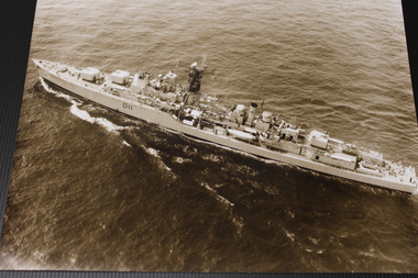
Photograph - HMAS Vampire
This item contributes to an understanding of those involved in the war in Vietnam.Photograph of an aerial shot of HMAS Vampire at seaD11hmas, vampire, navy, vietnam, destroyer -
 Bendigo Historical Society Inc.
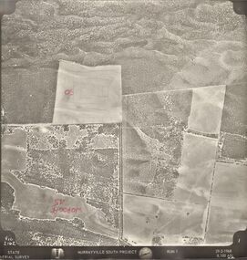
Photograph - MURRAYVILLE SOUTH PROJECT
State Aerial Survey. A set of aerial surveys related to the Murrayville South Project. Run 1. Vic. 2162. 29-2-1968. 53 photos.photograph, aerial, murrayville south project, photos, murrayville south project, state aerial survey, surveys, murrayville, photographs, photography, aerial photography -
 Port Melbourne Historical & Preservation Society
Photograph - Aerial view Webb Dock and Beacon Cove site, Port Melbourne, 6 Sep 1997
(.01) Aerial photographic view of Webb Dock - September 1997 (.02) Aerial view of cleared site for future Beacon Cove project - September 1997piers and wharves - webb dock, built environment, beacon cove -
Port Melbourne Historical & Preservation Society
Photograph - Double-sided aerial photograph, Hobson's Bay and the Yarra River/Port Phillip and Western Port Bay, Surveyor General and Director of Mapping, Apr 1990
Landsat imagery - an extract from the atlas of VictoriaAerial photos of Port Phillip and Western Port (double sided aerial photographs), framed and with timber display stand. 1995 side A: Hobson's Bay and Yarra River - aerial photo mosaic; side B. Port Phillip and Western Port Bays - satellite photomelbourne harbor trust - port of melbourne authority -
 Bayside Gallery - Bayside City Council Art & Heritage Collection
Photograph, Department of Crown Lands and Survey, Victoria, Melbourne Project: Brighton, 1976
The Department of Crown Lands and Survey (1857-1983) was responsible for the administration of survey and mapping and the sale, occupation and management of crown land throughout its existence. This aerial photograph shows parts of Brighton and was taken on 1 December 1976brighton, department of crown lands and survey, aerial photograph, bayside, port phillip bay, map, cartographic material, melbourne project 1976, brighton yacht club, middle brighton baths, north road, st kilda street, new street -
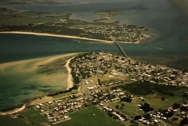 Phillip Island and District Historical Society Inc.
Photograph, Aerial photographs of Phillip Island, 1990s
Coloured photographs showing aerial views of the townships and the Island.rhyll, photographs, cowes, san remo, newhaven, aerial views of phillip island -
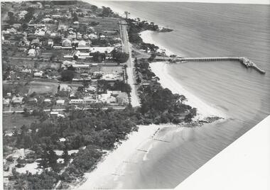 Phillip Island and District Historical Society Inc.
Photograph, Bryant West
One of a collection of over 400 Photographs in an Album commenced in 1960 and presented to the Phillip Island & Westernport Historical Society by the Shire of Phillip IslandAerial photograph of Cowes, Foreshore and Jetty looking west.local history, photography, photographs, cowes jetty foreshore, foreshore jetty cowes, aerial view of cowes phillip island, john jenner, bryant west -
 Phillip Island and District Historical Society Inc.
Photograph, Bryant West
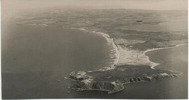
One of a collection of over 400 photographs in an album commenced in 1960 and presented to the Phillip Island & Westernport Historical Society by the Shire of Phillip Island.Aerial Photograph of Cape Woolamai looking north-west.local history, photography, photographs, coastline, cape woolamai, aerial view of cape woolamai, john jenner, bryant west -
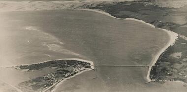 Phillip Island and District Historical Society Inc.
Photograph, Bryant West
One of a collection of over 400 photographs in an album commenced in 1960 and presented to the Phillip Island & Westernport Historical Society by the Shire of Phillip IslandAerial Photograph of Phillip island Bridge and Cleeland's Bight.local history, photography, photographs, civil engineering, bridges, phillip island bridge, coastline, bridge, phillip island, cleeland's bight, eastern passage phillip island, john jenner, bryant west -
 Glenelg Shire Council Cultural Collection
Photograph - Photograph - Thomas Borthwick & Sons Abattoir, Portland, n.d
Glenelg Shire Council Records. Portland Development Committee.Aerial view of Thomas Borthwick & Sons, Abattoir, PortlandBack: Blue stamp - Portland Development Commitee. Greylead - Thos. Borthwick & Sons (Australasia) P/L.borthwicks, thomas borthwick, abattoir -
 Glenelg Shire Council Cultural Collection
Photograph - Photograph - Southern Farmers & Australian Estates (Portland) Pty Ltd Wool Process, n.d
Port of Portland Authority archives.Front: (no inscriptions) Back: Portland Harbor Trust Commissioners (purple stamp, top left & bottom right).port of portland archives -
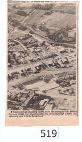 Greensborough Historical Society
Newspaper clipping, Greensborough shopping centre 1970, 1970_
The photograph is of the centre of Greensborough in 1970, prior to the Greensborough Plaza being built. The Partington farm house, named 'Alwyn' (after Alan and Wyn Partington) can be seen north of the Railway Line. Alan and Wyn had to leave this farm in 1976 - moving to a new house - built by son Gary - at 54 Manatunga Circuit - to make way for the creation of Whatmough Park and development of the Hailes Street-The Circuit-Greensborough Plaza precinct.This is an important visual record of Greensborough before the redevelopment of the late 1970's. It also shows the Whatmough park area when it was still the Partington family farm.A black and white newspaper clipping featuring an aerial photograph.Nilgreensborough streets, greensborough, aerial photograph, 1970, partington, whatmough park, greensborough swimming pool -
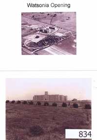 Greensborough Historical Society
Photographs, Watsonia opening; Loyola seminary. Circa 1934, 01/08/1934
The Society of Jesus (Jesuits) opened the seminary in 1934. These photographs were part of the advertising for the opening ceremony. The Jesuit Order had a presence on the site from 1934 to 1974 where a house of formation and studies for the Society of Jesus was located (the current Old Loyola building purchased by the College in 2002). Loyola College Watsonia now occupies the site.1934 photographs showing the site before the residential development in the area.Four photographs and one photocopy. Aerial and ground views.loyola college, jesuits, loyola seminary -
 Glenelg Shire Council Cultural Collection
Photograph - Photograph - Borthwicks, 1960s
Glenelg Shire Council records.Aerial photograph of Thomas Borthwick and Sons abattoir, Portland.Back: Photographers stamp - not complete.borthwicks, abattoir, rural, industry -
Glenelg Shire Council Cultural Collection
Photograph, Photograph - Thomas Borthwick and Sons, n.d
Port of Portland Authority Archivesport of portland -
Glenelg Shire Council Cultural Collection
Photograph - Photograph - Portland Harbour & Portland Town, 1958
Port of Portland Authority ArchivesBack: Purple stamp - 17 Nov 1958port of portland archives, portland harbour -
Glenelg Shire Council Cultural Collection
Photograph - Photograph - aerial view of Portland harbour, n.d
Port of Portland AuthorityBack: Harb022, pencil bottom right.port of portland archives, aerial photography, portland harbour -
Glenelg Shire Council Cultural Collection
Souvenir - Souvenir Badge - Portland Harbour, n.d
Shield shaped badge showing an aerial view of harbourbadge, souvenir, portland harbour, aerial -
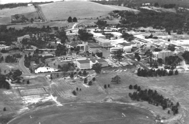 Federation University Historical Collection
Photograph - Photograph - Black and White, Aerial view of Ballarat Institute of Advanced Education Mount Helen Campus, 1983, c1983
The Mt Helen Campus is a Ballarat campus of Federation University Australia and was opened in 1970. Aerial view of Federation University's Mount Helen Campusmount helen, aerial, mount helen campus, ballarat streetscape -
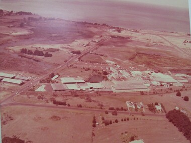
Glenelg Shire Council Cultural Collection
Photograph - Photograph - aerial view of Portland, 1976
Port of Portland Authority ArchivesBack: Tech School Must Street 1976- pencil 10.4.76port of portland archives, aerial photography, portland technical school -
Glenelg Shire Council Cultural Collection
Photograph - Photograph - aerial view of grain silos, Portland, n.d
Port of Portland Authority archivesFront: (no inscriptions) Back: P.H.T./ Print No. ... Neg. No 186/ Date taken .../ SUBJECT./ ... (Ink stamp with blue pen and pencil additions, centre)port of portland archives, aerial photography, portland harbour -
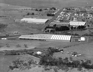
Glenelg Shire Council Cultural Collection
Photograph - Photograph - aerial view of Cresco factory, Portland, c. 1960
Port of Portland Authority archivesFront: (no inscriptions) Back: (no inscriptions)port of portland archives, aerial photography, cresco -
Glenelg Shire Council Cultural Collection
Photograph - Photograph - Airport, n.d
Port of Portland Authority ArchivesBack: Top right 'Airport' in pencil Top left - purple stamp 'When ordering pleas quote this number' '3074-A' in red biroport of portland archives, airport -
Glenelg Shire Council Cultural Collection
Photograph - Photograph - Reclamation, n.d
Port of Portland Authority Archivesport of portland archives, reclamation -
Glenelg Shire Council Cultural Collection
Photograph - Photograph - Portland Harbour Development, n.d
Port of Portland Authority Archivesport of portland -
Glenelg Shire Council Cultural Collection
Photograph - Photograph - Cape Grant Quarry, Portland, n.d
Port of Portland Authority ArchivesFront: Back- '40 cms wide'- pencilport of portland archives, cape grant quarry, portland harbour, harbour development -
Glenelg Shire Council Cultural Collection
Photograph - Photograph - Cape Grant Quarry, Portland, n.d
Port of Portland Authority Archivesport of portland archives, aerial photography, portland harbour, cape grant quarry -
Bendigo Historical Society Inc.
Photograph - AERIAL PHOTO OF BENDIGO
Large black and white aerial photograph of the city of Bendigo.bendigo, streetscape, aerial view -
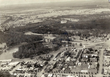 Echuca Historical Society
Aerial photograph Echuca 1927
Aerial photograph (scanned) 1927 Note open spaces -
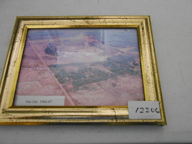 National Vietnam Veterans Museum (NVVM)
Photograph, Nui Dat 1966-67
Framed coloured aerial photograph of Nui Dat base.nui dat, photograph