Showing 11095 items
matching circa
-
 Ringwood and District Historical Society
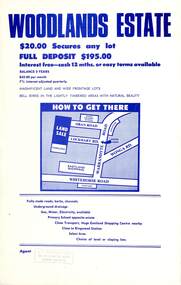
Flyer, Land Sale Advertisement - Woodlands Estate, North Ringwood, Victoria - circa 1970
Double sided single-page advertisement for land sale with locality map and layout of Woodlands Estate subdivision in North Ringwood, with summary of local features and services. No indication of date of flyer other than post-Eastland Shopping Centre opening in 1967.Subdivision includes Oban Road, Terrigal Close, Dorelaw Drive (later Melview Drive), Naroo Court, and Barook Court. Agent's rubber stamp imprint - H.C. Walton & Son, 264 Doncaster Road, North Balwyn. -
 Ringwood and District Historical Society
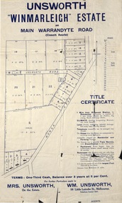
Flyer, Land Sale Advertisement - Unsworth Winmarleigh Estate, Ringwood, Victoria - circa 1912
Advertisement and attachment for subdivision of land adjoining Warrandyte Road coach route in North Ringwood, with map showing layout of subdivision, summary of local features and services, and terms of sale. Subdivision includes Wonga Road (later Loughnan Road & Warrandyte Road), Unsworth Road, Through Road, Cross Street, and John Street. Contacts - Mrs Unsworth on the Estate or W.M. Unsworth, 58 Little Latrobe Street, Melbourne, Telephone Central 7207. -
 Ringwood and District Historical Society
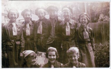
Photograph, Heathmont Guides - circa 1958
Black and white photograph"Attached to photograph" Back row L to R Robyn Cattermole, ?, Joan Eastaugh, Sandra Roberts, Jan Browning, Lois Burns Front row L to R Suzanne Cattermole, Adelyn Johnston, Lyn Eastaugh -
 Ringwood and District Historical Society
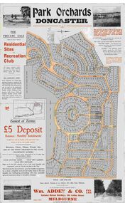
Map, Park Orchards Land Sale Advertisement, Doncaster, Victoria, Circa 1926
Large linen backed map of the Park Orchards subdivision for private sale of residential sites and recreation club, highlighting local facilities, services and layout of the estate. Surveyors - Tuxen & Miller, 34 Queen Street, Melbourne. Agents - Wm Addey & Co., Pty Ltd., National Mutual Buildings, 395 Collins Street, Melbourne, Phone F3906. Terms £5 deposit balance monthly installments of £1 with the residue at the end of five years. Subdivision includes Alva Avenue, Arundel Road, Aviemore Avenue, Berringa Road, Bowmore Avenue, Brucedale Crescent, Brympton Avenue, Camber Avenue, Cawdor Avenue, Colin Avenue, Corriedale Crescent, Craithie Avenue, Daintree Avenue, Dalry Avenue, Dirlton Crescent, Drayton Crescent, Elgin Crescent, Enfield Avenue, Ennismore Crescent, Euston Avenue, Feversham Avenue, Frogmore Crescent, Gosford Crescent, Granard Avenue, Hopetoun Road, Hylton Avenue (later Knees Road), Jura Avenue, Park Road. -
 Ringwood and District Historical Society
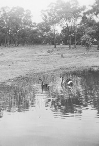
Photograph, Ringwood Lake estimated circa mid 1960s. Fourteen undated photographs taken around the Lake
The catalogue simply state the photographs are of "Ringwood Lake". -
 Ringwood and District Historical Society
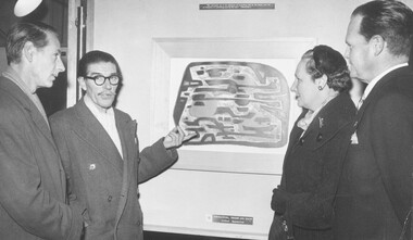
Photograph, Ringwood High School - Harry Hudson, Arts teacher. circa 1960. Composition: Yellow and Black - Alfred Manessier
Written on back of photograph, "Ringwood High School. Harry Hudson, Arts teacher". Composition: Yellow and Black - Alfred Manessier -
 Ringwood and District Historical Society
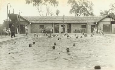
Photograph, Ringwood Baths, Ringwood Street, Ringwood - circa 1940
Black and white photograph of people swimming in pool with building in background. 2 copies- 1 large, 1 small.Typed below large photograph, "A day at the Old Ringwood Baths, Ringwood Street". Written on back of smaller copy, "The Mayor, Cr. J.K. McCaskill, JP, inspecting swimming pool". -
 Ringwood and District Historical Society
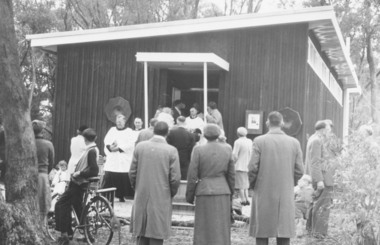
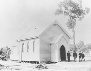
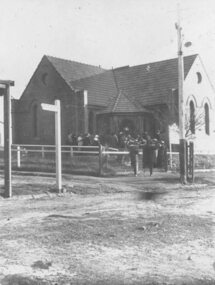
Photograph, Church of England, Patterson Street, East Ringwood, Vic. - circa 1960
Church of England Church at East Ringwood with people leavingWritten on back of photograph, "E. Rwd." Church of England Church at East Ringwood -
 Ringwood and District Historical Society
Photograph, Early Catholic Church Building, Bedford Road, Ringwood - circa 1960s and 1976, 1976
Old Catholic Church building in mid 1976Written on back of photographs, "Old Catholic Church - mid 1976". Written on back of enlargement, "Old Catholic Church, Ringwood - built 1893". -
 Ringwood and District Historical Society
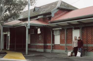
Photographs, Ringwood Railway Station buildings circa 2000
Collection of three Ringwood photographs:; 1. Ringwood Station (No 1 Platform); 2. Ringwood Station (No 2 Platform); 3. Ringwood signal box -
 Ringwood and District Historical Society
Photograph, St Paul's Church, Whitehorse Road, Ringwood, Vic. circa 1910
St Paul's Church on Whitehorse RoadWritten on back of photograph, "St. Paul's on highway." -
 Ringwood and District Historical Society
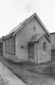
Photograph, Seventh Day Adventist Church, Bond Street, Ringwood - circa 1970
Seventh Day Adventist building Church buildingWritten on backing sheet, "Old Seventh Day Adventist building (Church)". Written on back of photographs, "Previously Seventh Day Adventist." -
 Ringwood and District Historical Society
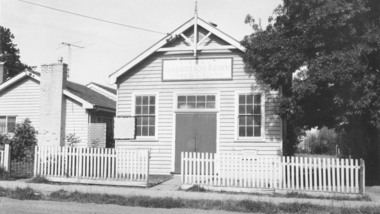
Photograph, Salvation Army Hall, Warrandyte Road, Ringwood - circa 1960s
Black and white photograph of wooden building with picket fence.Typed below photograph, "Salvation Army Hall, Warrandyte Road, Built 1920." Written on backing sheet, "Sal. Army Hall, 1/1964. Built 1920, W'dyte Rd." -
 Ringwood and District Historical Society
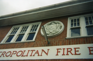
Photographs, Ringwood Fire Station at 255 Maroondah Highway circa 1998
This fire station was closed and a new one opened on Maroondah Highway on the site of the old miner's cottage near the corner of the Highway and Mt Dandenong Road.Five coloured photographs of the Ringwood fire station at 255 Maroondah Highway and of the fireman's house when it was sold. It later became 'The Fire Station Restaurant.' -
 Ringwood and District Historical Society
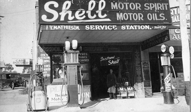
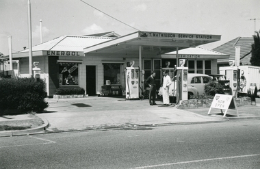
Photograph, T. Mathieson - Ringwood Service Station at Railway Station Entrance circa 1940s
Black and white photograph of Mathieson business over the years. Later sold bicycle parts and became a cycle shop. Tom's son, Stan took over the business and later moved down Maroondah Highway. Showing other businesses such as C.E. Carter & Son, Auctioneer & Estate Agents, Ward's Newsagency and Wadeson's Garage. -
 Ringwood and District Historical Society
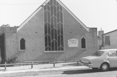
Photograph, Ringwood Methodist Church, cnr Greenwood Av. & Station St., Ringwood - circa 1920s
Written on backing sheet, "Ringwood Methodist Church, C/R Greenwood Av. & Station St." -
 Ringwood and District Historical Society
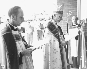
Photograph, Archbishop Wood, Rev. David Chambers, Church of England, Ringwood - circa 1960s
Written on back of photograph, "Archbishop Wood, Rev. David Chambers. C of E." -
 Ringwood and District Historical Society
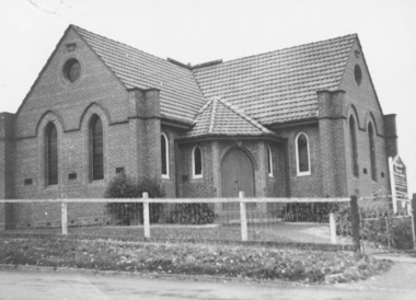
Photograph, Ringwood Methodist Church, Bedford Road/Station Street, Ringwood circa 1920
Written on backing sheet, "Methodist Church 1920?. Photo by Ron Anderson, Ringwood. Greenwood's shops on left." -
 Ringwood and District Historical Society
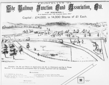
Photograph, Land sale prospectus - Railway Junction Land Association Ltd., Ringwood - circa 1890
Catalogue card reads, 'Early Sketch of Ringwood Layout (part). Not to scale but largely true to life of approximately 1890. Many local landmarks shown e.g. Wesleyan Chapel, Duncans Antimony Mine Hotel, Cass's School, Herry's Store. Maroondah Highway not shown but would approximate a line drawn from just to left of horse and cart near Chapel - North to pass around Antimony Mine and to the left to pass behind Cass's School.' -
 Ringwood and District Historical Society
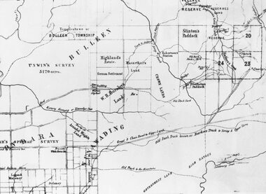
Photograph, Circa 1855 Parish Map including Bulleen, Nunawading, and eventual site of Ringwood below blocks 23 & 24
Catalogue card reads, "C1858 Parish Map - Nunawading, Ringwood & Scoresby". -
 Ringwood and District Historical Society
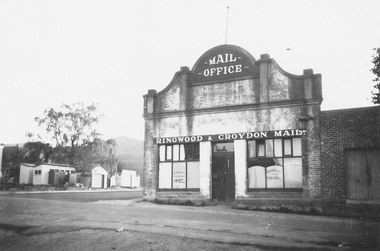
Photograph, Adelaide Street, Ringwood, showing 'Mail' Office - looking east. Demolished for Eastland parking area. Photograph circa early 1960s
Catalogue card reads, "Adelaide St. showing 'Mail' Office - looking east. Demolished for Eastland parking area". -
 Ringwood and District Historical Society
Photographs, Tom Mathieson BP service station at 74 Maroondah Hwy circa 1970s
-
 Ringwood and District Historical Society
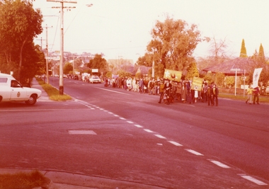
Photographs, Church Reconciliation march to all Ringwood Churches circa 1970
-
 Alexandra Timber Tramway & Museum
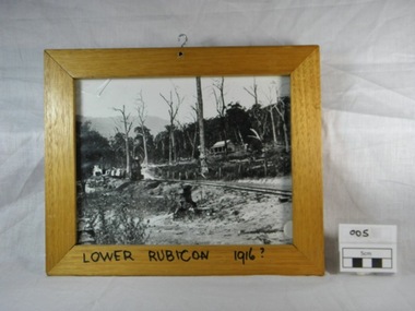
Framed black and white photograph, Untitled, Rails to Rubicon circa 1916, 1/1/1985 (estimated)
We have not statement of significanceWooden framed black and white photograph of a two foot gauge steel rail line from the mill sight to Alexandra. This locomotive, a Kraus, steam engine (year ?)is passing through Lower Rubicon. It hauls three carriages with timber and on the side of the rail there are open boxes. A wooden house on Gilmore's family property is halfway up the hill. The property shows signs of damage of the recent Goulburn River flooding in 1916. There is a hook in the top of the frame and writing on the bottom of the frame "Lower Rubicon 1916".On bottom of the frame "Lower Rubicon 1916?" written with black texta colour pen in capital letters. 1916, cottage, rail, locomotive, train, floods, dead trees, two foot gauge, timber stacks, goulburn river floods, gilmore, lower rubicon, carriages, rubicon, kraus -
 Federation University Historical Collection
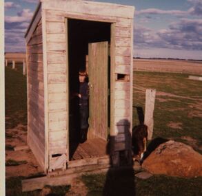
Photograph - Colour, Chatham-Holmes Collection: Andrew Chatham in the Out House, Kur-a-ruc South, Rokewood, Vic. {circa 1976)
Andrew Chatham, the youngest of Philip and Elizabeth Chatham's 5 children, was born in 1968. In this photo, he looks about 8 - 10 years old. The photo was taken at Rokewood, Victoria on his parent's Western District property, "Kur-a-ruc South" a former part of the Kur-a ruc Station, Rokewood, Victoria purchased by Philip and Elizabeth Chatham in 1964. The family lived at Ascot, 15 miles north of Ballarat, and had regular weekend day trips and Easter holidays picnicking, droving sheep, feeding stock, checking water troughs and dams, hand-weeding Patterson curse, repairing fences, collecting paddock rocks and sugar-gum wood at "Kur-a-ruc South'. Home base for these excursions was either a car, the shearing shed, sometimes a 6-berth caravan and by the mid-1980s a shearer's quarters with an inside toilet. [Jane Dyer (nee Chatham).15 June 2024] chatham-holmes collection, andrew chatham, outdoor shed, toilet facility, rokewood, kur-a-ruc south, rokewood -
 Ringwood and District Historical Society
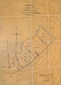
Plan, Subdivision of Crown Lot 19, Ringwood, Victoria - circa 1915
Surveyor's map on wax paperSubdivision map includes Mullum Creek, Government Road to Anderson's Creek, later Warrandyte Road, Government Road to Lillydale, later Whitehorse Road, small creek bridge, later Sandy Creek at Ringwood Lake. Buildings marked include Roman Catholic Church, O.J. Pratt's House and Pratt's butcher shop (photos attached). Map by A.B. Bruford & Co., Licensed Surveyor, 47 Queen Street, Melbourne. -
 Ringwood and District Historical Society
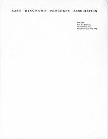
Letter, East Ringwood Progress Association letterhead circa late 1950s
East Ringwood Progress Association letterhead, showing Mrs H Wiltshire of 102 Railway Avenue, East Ringwood WU 6092 as Hon. Secretary. -
 Ringwood and District Historical Society
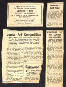
Newspaper, A selection of newspaper articles on the East Ringwood Progress Association Community Fair and Junior Art Competition circa 1960
East Ringwood Progress Association Community Fair and Junior Art Competition. -
 Ringwood and District Historical Society
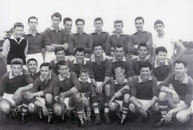
Photograph, East Ringwood Football Club (ERFC) 1955 (circa) Under 16
Originally framed and shown up the stairs at the former Maroondah Sporting Club, the home of the East Ringwood Football Club -
 Ringwood and District Historical Society
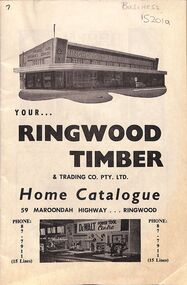
Pamphlet, Two catalogues from Ringwood Timber & Trading circa 1960s
Two catalogues of goods to sell, from Ringwood Timber & TradingEditorial of 15201b includes a short history of the company. In 1937, Mr S Coopersmith and son, Frank (the present Managing Director) started a fruit case manufacturing business in North Melbourne under the name of The Cooper Case Co. The business flourished, and in 1940, recognising the possibilities in and around Ringwood, an old bush sawmill and an area of land on the Maroondah Highway, were secured. Subsequent purchases have since increased this area to approximately 15 acres. It was decided to widen the activities and scope of the business and two new firms were formed. Cooper Sawmilling Co., which operated a modern sawmill, and Ringwood Timber & Trading Co., which handled the output of the sawmill and introduced builders' and general hardware lines to meet the demands of this rapidly expanding area. As Ringwood grew, so too did the organisation which was created to serve it. The principals studied timber and hardware merchandising trends overseas, and after considerable investigation the new building on Maroondah Highway was completed in 1956. Today, acclaimed as one of the most modern mills and hardware stores in the Southern Hemisphere, combining up to date machinery and handling equipment together with unique drive-in facilities and a self-selection centre. Ringwood Timber & Trading Co. are proud to offer a service unparallelled to home builders. In conformity with modern commercial practice the various firms have since been incorporated under the Victorian Companies Act and the latest accounting methods and office equipment have been installed to provide an efficient and virile administration to control the entire manufacturing and trading activities. We have a staff of over 220 personnel, each trained in their particular field to provide you, our valued client, with expert advice, quality merchandise and second-to-none service to enable you to fulfil every need in and around your home.