Showing 1106 items
matching east bendigo
-
 Bendigo Historical Society Inc.
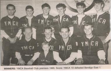
Newspaper - JENNY FOLEY COLLECTION: WINNERS
... Bendigo East 1. The clip is in a folder.... 1965. Score YMCA 10 defeated Bendigo East 1. The clip ...Bendigo Advertiser '' The way we were'' from 2002. Winners: YMCA Baseball Club premiers 1965. Score YMCA 10 defeated Bendigo East 1. The clip is in a folder.newspaper, bendigo advertiser, the way we were -
 Bendigo Historical Society Inc.
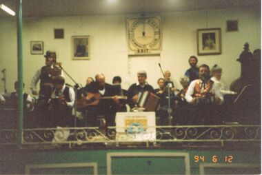
Photograph - PETER ELLIS COLLECTION: EMU CREEK BUSH BAND, 12th May, 1994
... reads: Bendigo East Hall 1994...: 94 6 12. Back of photo reads: Bendigo East Hall 1994 ...Colour photograph. Very blurry. Emu Creek Bush Band on stage with green facia. Date stamped: 94 6 12. Back of photo reads: Bendigo East Hall 1994entertainment, music, emu creek bush band -
 Bendigo Historical Society Inc.
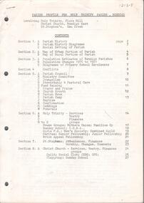
Document - CHURCHES OF BENDIGO COLLECTION: PARISH PROOFILE FOR HOLY TRINITY PARISH, BENDIGO
... - Christ Church, Bendigo East - St. Stephen's, Emu Creek.... Trinity, Flora hill - Christ Church, Bendigo East - St. Stephen's ...Twenty seven pages document. Parish profile for Holy Trinity Parish, Bendigo. Involving: Holy Trinity, Flora hill - Christ Church, Bendigo East - St. Stephen's, Emu Creek.church, history, anglican church -
 Bendigo Historical Society Inc.
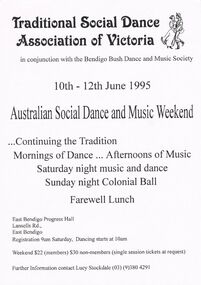
Document - PETER ELLIS COLLECTION: FOLK DANCE AND MUSIC ADVERTISEMENTS, 12th June, 1995
... 1995 at the East Bendigo Progress Hall. The green one... 1995 at the East Bendigo Progress Hall. The green one ...Five Folk Dance and Music advertisements. The white one is for an Australian Social Dance and Music Weekend held on 10th - 12th June 1995 at the East Bendigo Progress Hall. The green one is the TSDAV 1996 Dance Dates. The light blue is for TSDAV Dance Weekend held on the 8th - 10th November 1996 at the Foreshore Community Hall at Portarlington. There was a Dance Programme and Workshop Programme. The darker blue is for TSDAV 1994 for a Dance Composing Competition sponsored by the Vic. Folk Music Club. The cream one is an advertisement for a Concert presented by Folk Victoria. Two singers, Julie Felix and Judy Small appearing at the Brunswick Mechanics Institute on Saturday 18th February (no year). On the back are brief notes about Julie and Judy.clubs and associations, theatre, victorian traditional social dance, peter ellis collection, traditional social dance association of victoria, bendigo bush dance and music society, lucy stockdale, carol higman, colin towns, vic folk music club, folk victoria, julie felix, judy small, folk song & dance society victoria inc -
 City of Greater Bendigo - Civic Collection
Photograph - Portrait of Councillor Sibley, W H Robinson
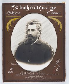
... of Greater Bendigo. The shire was located 8 km to the south- east... of Greater Bendigo. The shire was located 8 km to the south- east ...The district of Strathfieldsaye was proclaimed in 1861 and named a Shire on the 17th September in 1866. It remained a shire until amalgamation in 1994 when it became part of the City of Greater Bendigo. The shire was located 8 km to the south- east of Bendigo and covered an area of 601 square kilometres and extended from the Calder Highway to the Coliban and Campaspe Rivers. The shire's administration centre was in Strathfieldsaye until 1972 when new offices were opened in KenningtonFramed black and white head and shoulder portrait of Councillor Sibley with hand coloured and drawn detail. Profile slightly to left with walrus moustache and beard. Cut oval brown mount decorated with text, flowers and scrolls. Hand written title top and lower centre.Strathfieldsaye / Shire Council / W m Robinson / Photo / Bendigo / J N B Gribble / Cr Robert R Sibley / First President Chairman of the Road Board 1865 - 5 / President 1866 - 1869 / With Mrs Sibley's Complimentsstrathfieldsaye shire council, councillor sibley, president of strathfieldsaye shire -
 City of Greater Bendigo - Civic Collection
Photograph - Portrait of Councillor Hargraves, Bartlett Bros
... of Greater Bendigo. The shire was located 8 km to the south- east... to the south- east of Bendigo and covered an area of 601 square ...The district of Strathfieldsaye was proclaimed in 1861 and named a Shire on the 17th September in 1866. It remained a shire until amalgamation in 1994 when it became part of the City of Greater Bendigo. The shire was located 8 km to the south- east of Bendigo and covered an area of 601 square kilometres and extended from the Calder Highway to the Coliban and Campaspe Rivers. The shire's administration centre was in Strathfieldsaye until 1972 when new offices were opened in KenningtonFramed black and white head and shoulder portrait of Councillor Hargraves. Profile slightly to right with walrus moustache. Cut rectangle brown mount decorated with coloured text and scrolls. Hand written title top and lower centre.Strathfiledsaye Shire Council / Cr John Hargreaves / President 1919 - 20 1928 - 29 / Presented by his Wife & Familystrathfieldsaye shire council, president of strathfieldsaye shire, councillor hargreaves -
 City of Greater Bendigo - Civic Collection
Photograph - Portrait of Councillor Long, Talma & Co
... of Greater Bendigo. The shire was located 8 km to the south- east... was located 8 km to the south- east of Bendigo and covered an area ...The district of Strathfieldsaye was proclaimed in 1861 and named a Shire on the 17th September in 1866. It remained a shire until amalgamation in 1994 when it became part of the City of Greater Bendigo. The shire was located 8 km to the south- east of Bendigo and covered an area of 601 square kilometres and extended from the Calder Highway to the Coliban and Campaspe Rivers. The shire's administration centre was in Strathfieldsaye until 1972 when new offices were opened in Kennington.Framed black and white head and shoulder portrait of Councillor Long. Profile to left with walrus moustache and mutton chops. Cut olive retangle mount. Verso; Long. On under board which has photograph attached; Talma & Co. / 119 Swanston St., / Melbournestrathfieldsaye shire council, councillor long -
 City of Greater Bendigo - Civic Collection
Photograph - Portrait of Councillor Doak, W H Robinson
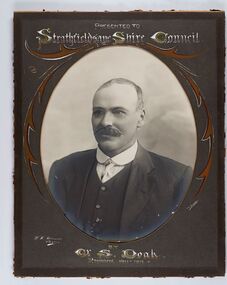
... of Greater Bendigo. The shire was located 8 km to the south- east... was located 8 km to the south- east of Bendigo and covered an area ...The district of Strathfieldsaye was proclaimed in 1861 and named a Shire on the 17th September in 1866. It remained a shire until amalgamation in 1994 when it became part of the City of Greater Bendigo. The shire was located 8 km to the south- east of Bendigo and covered an area of 601 square kilometres and extended from the Calder Highway to the Coliban and Campaspe Rivers. The shire's administration centre was in Strathfieldsaye until 1972 when new offices were opened in Kennington.Framed black and white head and shoulder portrait of Councillor Doak with hand coloured and drawn detail. Left facing profile with walrus moustache. Cut oval brown mount decorated with text and scrolls. Hand written title top and lower centre.Presented to / Strathfieldsaye Shire Council / W. H. Robinson / Photo / JMB Gribble / by Cr S. Doak / President 1911 - 1912strathfieldsaye shire council, president of strathfieldsaye shire, councillor doak -
 City of Greater Bendigo - Civic Collection
Photograph - Portrait of Councillor Keck, W H Robinson, c 1913
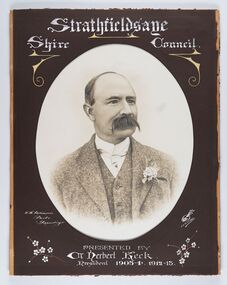
... of Greater Bendigo. The shire was located 8 km to the south- east.... The shire was located 8 km to the south- east of Bendigo and covered ...The district of Strathfieldsaye was proclaimed in 1861 and named a Shire on the 17th September in 1866. It remained a shire until amalgamation in 1994 when it became part of the City of Greater Bendigo. The shire was located 8 km to the south- east of Bendigo and covered an area of 601 square kilometres and extended from the Calder Highway to the Coliban and Campaspe Rivers. The shire's administration centre was in Strathfieldsaye until 1972 when new offices were opened in Kennington.Framed black and white head and shoulder portrait of Councillor Keck with hand coloured and drawn detail. Profile slightly to right with walrus moustache. Cut oval brown mount decorated with text and flowers. Hand written title top and lower centre.Strathfieldsaye / Shire Council / W.H. Robinson / Photo / Bendigo / J.H.E Gribbs / Presented by / Cr Herbert Keck / President 1903-4. 1912-13.shire of strathfieldsaye, councillor keck, strathfieldsaye shire council, president of strathfieldsaye shire -
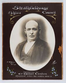 City of Greater Bendigo - Civic Collection
Photograph - Portrait of Councillor Michael Condon, W H Robinson
... of Greater Bendigo. The shire was located 8 km to the south- east... of Greater Bendigo. The shire was located 8 km to the south- east ...The district of Strathfieldsaye was proclaimed in 1861 and named a Shire on the 17th September in 1866. It remained a shire until amalgamation in 1994 when it became part of the City of Greater Bendigo. The shire was located 8 km to the south- east of Bendigo and covered an area of 601 square kilometres and extended from the Calder Highway to the Coliban and Campaspe Rivers. The shire's administration centre was in Strathfieldsaye until 1972 when new offices were opened in KenningtonFramed black and white head and shoulder portrait of Councillor Condon with hand coloured and drawn detail. Profile slightly to left. No facial hair. Cut oval brown mount decorated with text, scrolls and flowers. Hand written title top and lower centre.Strathfieldsaye / Shire / Council / W. H. Robinson / Photo / Bendigo / JMB Gribble / Presented by / Cr Michael Condon / President 1889 - 90. 1895-6. 1904 - 5strathfieldsaye shire council, president of strathfieldsaye shire, councillor condon -
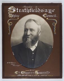 City of Greater Bendigo - Civic Collection
Photograph - Portrait of Councillor Thomas Somerville, W H Robinson
... of Greater Bendigo. The shire was located 8 km to the south- east.... The shire was located 8 km to the south- east of Bendigo and covered ...The district of Strathfieldsaye was proclaimed in 1861 and named a Shire on the 17th September in 1866. It remained a shire until amalgamation in 1994 when it became part of the City of Greater Bendigo. The shire was located 8 km to the south- east of Bendigo and covered an area of 601 square kilometres and extended from the Calder Highway to the Coliban and Campaspe Rivers. The shire's administration centre was in Strathfieldsaye until 1972 when new offices were opened in KenningtonFramed black and white head and shoulder portrait of Councillor Somerville with hand drawn detail. Profile slightly to left, face has full beard. Cut oval brown mount decorated with text and scrolls. Hand written title top and lower centre.Presented to / Strathfieldsaye / Shire Council / W. H. Robinson / Photo / Bendigo / by / Cr Thomas Somerville / President 1892 - 3. 1901.2. 1910.11 strathfieldsaye shire council, councillor somerville, president of strathfieldsaye shire -
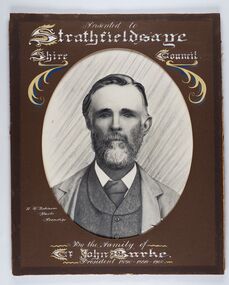 City of Greater Bendigo - Civic Collection
Photograph - Portrait of Councillor Burke
... of Greater Bendigo. The shire was located 8 km to the south- east... to the south- east of Bendigo and covered an area of 601 square ...The district of Strathfieldsaye was proclaimed in 1861 and named a Shire on the 17th September in 1866. It remained a shire until amalgamation in 1994 when it became part of the City of Greater Bendigo. The shire was located 8 km to the south- east of Bendigo and covered an area of 601 square kilometres and extended from the Calder Highway to the Coliban and Campaspe Rivers. The shire's administration centre was in Strathfieldsaye until 1972 when new offices were opened in Kennington. Framed black and white head and shoulder portrait of Councillor Burke with hand coloured and drawn detail. Profile centre facing with beard. Cut oval brown mount decorated with text and fscrolls. Hand written title top and lower centre. Wooden frame with detail and gold inner.Presented to Strathfieldsaye / shire Council / w. H. robinson / Photo / Bendigo / By the family of / Cr John Burke / President 1890 - 1899 - 1900strathfieldsaye shire council, councillor burke, president of strathfieldsaye shire -
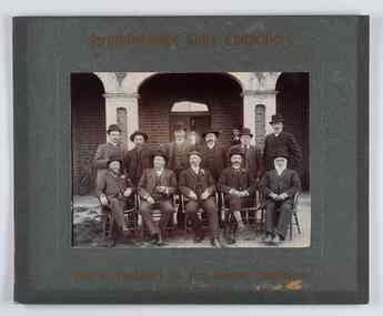 City of Greater Bendigo - Civic Collection
Photograph - Councillor group portrait, W H Robinson, Strathfieldsaye Shire Council, 1909
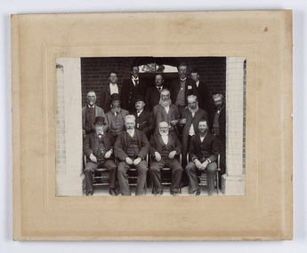
... of Greater Bendigo. The shire was located 8 km to the south- east... was located 8 km to the south- east of Bendigo and covered an area ...The district of Strathfieldsaye was proclaimed in 1861 and named a Shire on the 17th September in 1866. It remained a shire until amalgamation in 1994 when it became part of the City of Greater Bendigo. The shire was located 8 km to the south- east of Bendigo and covered an area of 601 square kilometres and extended from the Calder Highway to the Coliban and Campaspe Rivers. The shire's administration centre was in Strathfieldsaye until 1972 when new offices were opened in Kennington.Photographic group portrait of eleven Strathfieldsaye Shire Councillors in front of the Strathfieldsaye Shire Hall. Five men are seated and six standing with one man standing further in back ground on the building's verandah. Photograph is attached directly to green mount card and framed. Gold lettering on mount.Strathfieldsaye Shire Councillors / R. B. Brennan (Sec.) W. J. Lowdes S. Doak M. Burns () N Condon B. Code (Inspector) / WH Robinson Photo Bendigo / T Somerville / W. I. Long / Fred Osborne (President) H Keck / W Dresler / With the President's (Cr. Fred Osborne) Compliments / September 23rd, 1909shire of strathfieldsaye, strathfieldsaye shire council, president of strathfieldsaye shire, strathfieldsaye shire hall -
 City of Greater Bendigo - Civic Collection
Photograph - Councillor group portrait, W H Robinson, Strathfieldsaye Shire Council
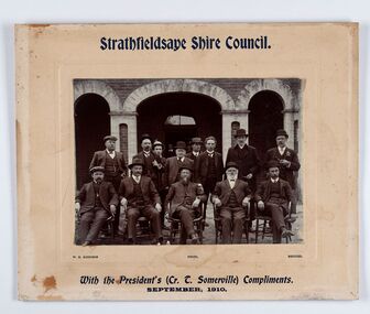
... of Greater Bendigo. The shire was located 8 km to the south- east... was located 8 km to the south- east of Bendigo and covered an area ...The district of Strathfieldsaye was proclaimed in 1861 and named a Shire on the 17th September in 1866. It remained a shire until amalgamation in 1994 when it became part of the City of Greater Bendigo. The shire was located 8 km to the south- east of Bendigo and covered an area of 601 square kilometres and extended from the Calder Highway to the Coliban and Campaspe Rivers. The shire's administration centre was in Strathfieldsaye until 1972 when new offices were opened in Kennington. Group portrait of 13 men / councilors, 5 seated and 8 standing dressed in suits. There are another 2 men further back in front of the hall doors. Photograph is taken outside the Strathfieldsaye Shire Hall.Srathfieldsaye Shire Council. / With the President's (Cr T. Somerville) Compliments. / September, 1910 / W.H. Robinson Photo. Bendigo Verso; William Drechslershire of strathfieldsaye, president of strathfieldsaye shire, strathfieldsaye shire council -
 City of Greater Bendigo - Civic Collection
Photograph - Strathfieldsaye Councillor Group Portrait, D.G. Coope & Son - Framers
... of Greater Bendigo. The shire was located 8 km to the south- east... of Greater Bendigo. The shire was located 8 km to the south- east ...The district of Strathfieldsaye was proclaimed in 1861 and named a Shire on the 17th September in 1866. It remained a shire until amalgamation in 1994 when it became part of the City of Greater Bendigo. The shire was located 8 km to the south- east of Bendigo and covered an area of 601 square kilometres and extended from the Calder Highway to the Coliban and Campaspe Rivers. The shire's administration centre was in Strathfieldsaye until 1972 when new offices were opened in Kennington.Silver gelatin framed photographic group portrait of fifteen men taken in the alcove of the Strathfieldsaye Shire Hall. Four men are seated and eleven are standing. Photograph is attached directly to cream mount card. Handwritten note with photograph: 1/ John Burke, 2/ (?), 3/ (?), 4/ RHS Abbott, 5/ M Brennan, 6/(?) 7/(?) 1/. M Condon? 2/ (?) 3/ M Burns, 4/(?) Gentlemen at back probably are council staff.shire of strathfieldsaye, strathfieldsaye shire council, president of strathfieldsaye shire, councillor john burke, councillor r.h.s. abbott, councillor brennan, councillor condon, councillor m burns -
 Bendigo Historical Society Inc.
Photograph - PETER ELLIS COLLECTION: DANCING
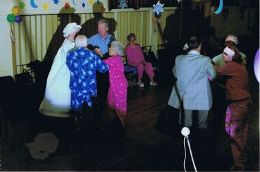
... Dance and Music Club Pyjama Dance Bendigo East Hall.... Pyjama Dance Bendigo East Hall. Photograph PETER ELLIS COLLECTION ...Colour photograph. Couples dancing in hall wearing pyjamas. Balloons on wall Hanging stars and moon Back of photo reads: Bush Dance and Music Club Pyjama Dance Bendigo East Hall.clubs, music, bush dance & music club of bendigo -
 Bendigo Historical Society Inc.
Map - CAMPBELL COLLECTION: BENDIGO AND DISTRICT MAPS, 1982
... , Bendigo East, City of Bendigo, West Bendigo, Kennington, Shire... Bendigo, Bendigo East, City of Bendigo, West Bendigo, Kennington ...Map. Forest Commission Victoria, Bendigo Forest District, Greater Bendigo Area. Shire of Marong, Sailors Gully, Epsom, Borough of Eaglehawk, Jackass Flat, White Hills, California Gully, Shire of Huntly, Maiden Gully, Long Gully, North Bendigo, Bendigo East, City of Bendigo, West Bendigo, Kennington, Shire of Strathfieldsaye, Flora Hill, Quarry Hill, Golden Square, Kangaroo Flat, Spring Gully. Prevention Strategy Plan. Base prepared 1982.map, bendigo, forest district -
 Bendigo Historical Society Inc.
Document - VAL CAMPBELL COLLECTION: CERTIFICATE OF APPRECIATION TO VAL CAMPBELL FROM THE CITY OF GREATER BENDIGO 2018, 2018
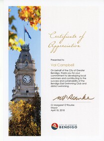
... to the success and sustainability of the Bendigo East Swimming club... and contributing to the success and sustainability of the Bendigo East ...CERTIFICATE of Appreciation to Val Campbell from the city of greater Bendigo April 18th 2018 for contribution for your commitment to developing local swimmers and contributing to the success and sustainability of the Bendigo East Swimming club and district swimmingrecreations, sports, swimming -
 City of Greater Bendigo - Civic Collection
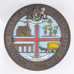
Sign - Shire of Strathfieldsaye Coat of Arms
... of Greater Bendigo. The shire was located 8 km to the south- east... of Greater Bendigo. The shire was located 8 km to the south- east ...The district of Strathfieldsaye was proclaimed in 1861 and named a Shire on the 17th September in 1866. It remained a shire until amalgamation in 1994 when it became part of the City of Greater Bendigo. The shire was located 8 km to the south- east of Bendigo and covered an area of 601 square kilometres and extended from the Calder Highway to the Coliban and Campaspe Rivers. The shire's administration centre was in Strathfieldsaye until 1972 when new offices were opened in Kennington. This coat of arms was commissioned for the front of the shire hall building.Brass painted coat of arms or emblem within a circle of the Shire of Strathfieldsaye. Outer rim contains text: SHIRE OF STRATHFIELDSAYE VICTORIA 1866 with the shield of the monarch of the United Kingdom centre top. The shield is divided into four parts with images reflecting the leading industries of the time; wine growing, mining, farming and tanning. The motto PROGRESS is depicted lower centre of shield. SHIRE OF STRATHFIELDSAYE / VICTORIA / 1866 / PROGRESSshire of strathfieldsaye, city of greater bendigo amalgamation, city of greater bendigo signs -
 Bendigo Historical Society Inc.
Document - ''THE CHINESE ON THE BENDIGO GOLDFIELD'': PAPER BY ''JOCH'' ( J. O. O'HATTAM)
... , East Bendigo (Grassy Flat) and ''as far out as Diamond Hill..., East Bendigo (Grassy Flat) and ''as far out as Diamond Hill ...''The Chinese on the Bendigo Goldfield'' - draft paper with pencilled and typed annotations by ''Joch'' (J O O'Hattam) - undated. ; last page states ''Extracts from letters in the O'Breen family, and personal research; These letters were written between 1856 and 1899 by Shane O'Breen''. Mention of - two distinct 'groups' of Chinese (Canton & via California) with their stated differences in appearance and type of working; differences between European and Chinese mines (shafts as well as drives i.e. circular as against rectangular; 'smoking' of the shafts and tunnels by the Chinese; space in Chinese camps i.e. crowding; condition of Chinese camps; fire at Emu Creek camp of 1887; names of camps - Golden Square, Jackass Flat, Myers Flat, Kangaroo Flat, White Hills, Kennington, East Bendigo (Grassy Flat) and ''as far out as Diamond Hill''; Constable Ryan disappearance.Shane O'Breenbendigo, chinese, history, goldfields, chinese. o'breen family, shane o'breen, constable ryan. pigtail. cantonese. chinese smoked shafts and tunnels. emu point. opium smoking shop. joss house. golden square. jackass flat, myers flat, kangaroo flat. white hills, kennington. west bendigo (grassy flat). diamond hill. -
 Bendigo Historical Society Inc.
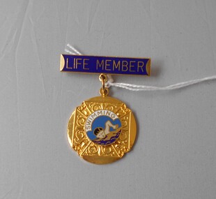
Award - VAL CAMPBELL COLLECTION: LIFE MEMBERSHIP AWARD, 1997
... Membership of the Bendigo East Swimming Club presented to Valma... 19.5.97.' Certificate of Life Membership of the Bendigo East ...Gold coloured metal medallion suspended from gold bar with enamelled surface. Bar has the words Life Member in gold on blue background. Medallion is a round shape with a fancy pattern in gold surrounding an enamelled centre with the word Swimming surrounding a picture of a person swimming. On the reverse the following words are engraved 'B.E.S.C. Val Campbell 19.5.97.' Certificate of Life Membership of the Bendigo East Swimming Club presented to Valma Campbell dated 15 May 1997. Certificate is printed on cream coloured card with a gold decorative border and black writing. The words are Bendigo East Swimming Club This is to certify that Valma (Val) Campbell has been elected a Life Member of the above club in appreciation of services rendered Dated at Bendigo East this fifteenth day of May 1997 Hon President (signature) Hon Secretary (signature).recreations, sports, swimming -
 Bendigo Historical Society Inc.
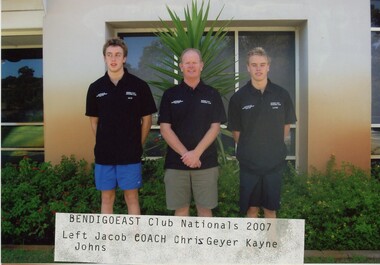
Photograph - VAL CAMPBELL COLLECTION: PHOTOGRAPH OF THREE MEN JACOB LOWRY CHRIS GEYER (COACH) AND KAYNE JOHNS BENDDIGO EAST CLUB NATIONALS 2007, 2007
... johns benddigo east club nationals 2007 On Rear: Bendigo East... On Rear: Bendigo East Club Nationals 2997 Jacob Lowry (Left) Chris ...PHOTOGRAPH OF three men Jacob (coach) Chris Geyer and kayne johns benddigo east club nationals 2007 On Rear: Bendigo East Club Nationals 2997 Jacob Lowry (Left) Chris Geyer (Coach) Kayne Johnsrecreations, sports, swimming -
Bendigo Historical Society Inc.
Map - CAMPBELL COLLECTION: BENDIGO AND DISTRICT MAPS, 1982
... , North Bendigo, City of Bendigo, Bendigo East, Kennington, West... East, Kennington, West Bendigo, Golden Square, Quarry Hill ...Map. Forest Commission Victoria, Bendigo Forest District, Sub-Plan 1 District Fire Prevention Plan, Greater Bendigo Area. Prevention Strategy Plan. Shire of Marong, Shire of Huntly, Borough of Eaglehawk, Shire of Strathfieldsaye, Sailors Gully, Epsom, Jackass Flat, White Hills, California Gully, Maiden Gully, Long Gully, North Bendigo, City of Bendigo, Bendigo East, Kennington, West Bendigo, Golden Square, Quarry Hill, Flora Hill, Spring Gully, Kangaroo Flat.Base prepared 1982. (number 397 in map cupboard 1)map, bendigo, forest district -
 Bendigo Historical Society Inc.
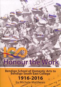
Book - HONOUR THE WORK
... bendigo south east...Honour the Work, Bendigo School of Domestic Arts to Bendigo... BOOKS School bendigo south east Michele Matthews Honour the Work ...Honour the Work, Bendigo School of Domestic Arts to Bendigo South East College 1916-2016, 108 pages in soft cover with colour and black & white photographs.Michele Matthewsbooks, school, bendigo south east -
 City of Greater Bendigo - Civic Collection
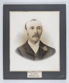
Photograph - Portrait of Councillor Orr, The Yeoman Studios, Ex. Councillor / F. Orr / Eppalock
... of Greater Bendigo. The shire was located 8 km to the south- east... to the south- east of Bendigo and covered an area of 601 square ...The district of Strathfieldsaye was proclaimed in 1861 and named a Shire on the 17th September in 1866. It remained a shire until amalgamation in 1994 when it became part of the City of Greater Bendigo. The shire was located 8 km to the south- east of Bendigo and covered an area of 601 square kilometres and extended from the Calder Highway to the Coliban and Campaspe Rivers. The shire's administration centre was in Strathfieldsaye until 1972 when new offices were opened in Kennington. Eppalock Ward is one of three wards in the Greater Bendigo municipality which includes the former Strathfieldsaye Shire. Framed black and white head and shoulder portrait with hand coloured detail. Man with profile slightly to right, walrus moustache, image encircled. Photograph is attached to mount card. Hand written title lower centre.Ex. Councillor / F. Orr / Eppalock / The / Yeoman / Studiosshire of strathfieldsaye, councillor orr -
 Bendigo Historical Society Inc.
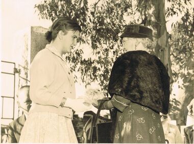
Photograph - BERT GRAHAM COLLECTION: MAUREEN CHARLES AND MRS TULLY, May 1957
... Charles from the Bendigo East Swimming Club is presenting a posie... Collection, Maureen Charles from the Bendigo East Swimming Club ...Black & white photograph, Bert Graham Collection, Maureen Charles from the Bendigo East Swimming Club is presenting a posie of flowers to Mrs. J.P.Tully at the opening of the gates at Eastern Park in May 1957. Names on back including 9. 6.1957 AHG.bendigo, clubs, eastern park -
 Bendigo Historical Society Inc.
Photograph - VAL CAMPBELL COLLECTION: PHOTOGRAPH OF CHILD SWIMMERS, 1993
... in front of a wall at the Bendigo East Swimming Club. Most of them... swimmers standing in front of a wall at the Bendigo East Swimming ...Colour photo of a group of 12 child swimmers standing in front of a wall at the Bendigo East Swimming Club. Most of them are holding either a pennant or have a medal around their necks. Written on the back of the photo: Central District winners & place getters 1993.recreations, sports, swimming -
Bendigo Historical Society Inc.
Document - MINING REPORTS - LINE OF REEF AT YANKEE CREEK NEAR BENDIGO
... refers to a locality, eight miles due east from Bendigo, and five... refers to a locality, eight miles due east from Bendigo, and five ...Typed photocopy of a letter dated September 19th, 1898 from W. H. Cundy, Underground Survey Office, Bendigo. Letter refers to a locality, eight miles due east from Bendigo, and five miles west from Hunt's line of Reef Ellesmere. The writer did not think there was any necessity for a special survey to define the position of the reef. Handwritten at the bottom of the letter: for Report by Whitelaw See Progress Report No 10.document, gold, mining reports, mining reports, line of reef at yankee creek near bendigo, underground survey office bendigo, c tillach, koch's pioneer battery, mr grieve, hallidays claim, w h cundy, whitelaw -
 City of Greater Bendigo - Civic Collection
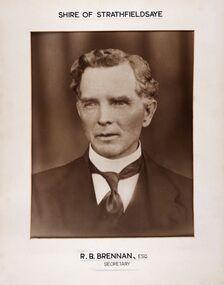
Photograph - Portrait of Shire Secretary Brennan, Unknown
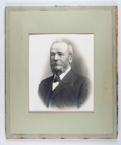
... of Greater Bendigo. The Shire was located 8 km to the south- east... of Greater Bendigo. The Shire was located 8 km to the south- east ...The district of Strathfieldsaye was proclaimed in 1861 and named a Shire on the 17th September in 1866. It remained a shire until amalgamation in 1994 when it became part of the City of Greater Bendigo. The Shire was located 8 km to the south- east of Bendigo and covered an area of 601 square kilometres and extended from the Calder Highway to the Coliban and Campaspe Rivers. The shire's administration centre was in Strathfieldsaye until 1972 when new offices were opened in Kennington. Secretary Brennan, son of Councillor M. Brennan was appointed after his fathers death to the role and according to the The Bendigo Independent was in the role in 1917. See References.Framed black and white head and shoulder portrait of Councillor Brennan. Profile slightly to left. Cut rectangle cream mount. Hand written title top and lower centre. Shire of Strathfieldsaye / R. B. Brennan, Esq / Secretarystrathfieldsaye shire council, secretary strathfieldsaye shire -
 Bendigo Historical Society Inc.
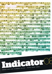
Magazine - GOLDEN SQUARE SECONDARY COLLEGE COLLECTION: YEAR BOOK 2008, 2008
... Bendigo South East Secondary College - Golden Square Campus...Bendigo Historical Society Inc. Bendigo Historical Society ...Bendigo South East Secondary College - Golden Square Campus ''Indicator'' Year Book 2008. Black, White and Yellow Cover With Green Student Photographs. Legacy of Golden Square Themebendigo, education, golden square secondary history, 258, y86