Showing 12750 items
matching estates
-
 Kew Historical Society Inc
Plan - Subdivision Plan, Cotham Vale Estate, 1919
Pru Sanderson, in her groundbreaking ‘City of Kew Urban Conservation Study : Volume 2 - Development History’ (1988), summarised the periods of urban development and subdivisions of land in Kew. The periods that she identified included 1845-1880, 1880-1893, 1893-1921, 1921-1933, 1933-1943, and Post-War Development. These periods were selected as they represented periods of rapid growth or decline in urban development. An obvious starting point for Sanderson’s groupings involved population growth and the associated economic cycles. These cycles also highlighted urban expansion onto land that was predominantly rural, although in other cases it represented the decline and breakup of large estates. A number of the plans in the Kew Historical Society’s collection can also be found in other collections, such as those of the State Library of Victoria and the Boroondara Library Service. A number are however unique to the collection.The Kew Historical Society collection includes almost 100 subdivision plans pertaining to suburbs of the City of Melbourne. Most of these are of Kew, Kew East or Studley Park, although a smaller number are plans of Camberwell, Deepdene, Balwyn and Hawthorn. It is believed that the majority of the plans were gifted to the Society by persons connected with the real estate firm - J. R. Mathers and McMillan, 136 Cotham Road, Kew. The Plans in the collection are rarely in pristine form, being working plans on which the agent would write notes and record lots sold and the prices of these. The subdivision plans are historically significant examples of the growth of urban Melbourne from the beginning of the 20th Century up until the 1980s. A number of the plans are double-sided and often include a photograph on the reverse. A number of the latter are by noted photographers such as J.E. Barnes.The Cotham Vale Estate was a subdivision of land between Alfred, Thomas, Rowland and John Streets. It was promoted in the same time as the nearby Normanby Heights Estate. Cotham Vale included 28 allotments. Contemporary newspaper advertisements noted that the Estate ‘is most conveniently situated in a well elevated position, only 2 minutes from Cotham rd. Electric Cars, penny section to Kew station’.subdivision plans - kew, cotham vale estate, rowland street -- kew (vic.), thomas street -- kew (vic.), john street -- kew (vic.) -
 Whitehorse Historical Society Inc.
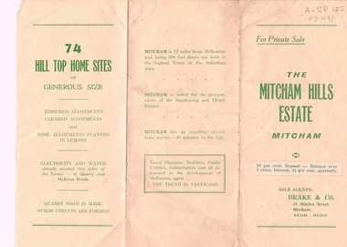
Document, Mitcham Hills Estate, n.d
Sale brochure for 'Mitcham Hills Estate',Sale brochure for 'Mitcham Hills Estate', 74 sites bordered by McKeon and Quarry Roads, to the order of Commander H.E. Turner and Mrs Turner. Agent: Drake & Co.. With 'List of Sale Prices'.Sale brochure for 'Mitcham Hills Estate',land subdivision, mitcham hills estate, mckeon road, mitcham, quarry road, endeavour street, moresby street, beaufort street, turner, harold exton, cmdr., (mrs), drake & co. -
 Whitehorse Historical Society Inc.
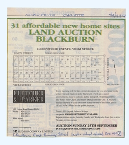
Article, Land Auction, Blackburn, 7/09/1994 12:00:00 AM
old Blackburn Advertisement in the Nunawading Gazette 7 September 1994Advertisement in the Nunawading Gazette 7 September 1994 for auction of the old Blackburn East Primary School (closed December 1993) land. Auction 25 September 1994. Greenwood Estate, Nicoli Street.old Blackburn Advertisement in the Nunawading Gazette 7 September 1994 land subdivision, bindy street, blackburn south, vicki street, sandra street, blackburn east primary school, no. 4800 -
 Whitehorse Historical Society Inc.
Document, Land Brochures, 1929
Photocopies of sale brochures of land in Mitcham by Coghill & Haughton in conjunction with Drake & Co.Photocopies of sale brochures of land in Mitcham by Coghill & Haughton in conjunction with Drake & Co. Includes (a) General advertisement for Mitcham. (b) Station Front estate and Whitehorse Hill estate. (c) Detail of Station Front Estate. (d) Detail of Whitehorse Hill estate.Photocopies of sale brochures of land in Mitcham by Coghill & Haughton in conjunction with Drake & Co.mitcham, coghill & haughton, drake & co., the esplanade, auctions, walker, edgar edwardes, donald, station front estate, whitehorse hill estate, whitehorse road, mitcham road, barkly terrace, calcutta street, delhi street, benares street, simla street, land subdivision -
 Kew Historical Society Inc
Plan - Subdivision Plan, Doona Estate, Toorak, 1929
The Kew Historical Society collection includes almost 100 subdivision plans pertaining to suburbs of the City of Melbourne. Most of these are of Kew, Kew East or Studley Park, although a smaller number are plans of Camberwell, Deepdene, Balwyn and Hawthorn. It is believed that the majority of the plans were gifted to the Society by persons connected with the real estate firm - J. R. Mathers and McMillan, 136 Cotham Road, Kew. The Plans in the collection are rarely in pristine form, being working plans on which the agent would write notes and record lots sold and the prices of these. The subdivision plans are historically significant examples of the growth of urban Melbourne from the beginning of the 20th Century up until the 1980s. A number of the plans are double-sided and often include a photograph on the reverse. A number of the latter are by noted photographers such as J.E. Barnes.The Doona Estate subdivision of 1929 created 11 new allotments bordered by Glenferrie Road, Stonnington Place, Cross and Church Streets. On the right of the plan, the location of ‘State Govt. House’ is noted. Stonnington was to be maintained as Victoria’s Government House until 1931, two years after the Doona Estate subdivision was released.subdivision plans - toorak, doona estate -
 Hume City Civic Collection
Photograph, c late 1980s
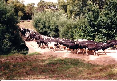
The series of photographs show a number of sites included in the Rupertswood Estate. By 1851 William Clarke had acquired 31,375 acres of land in the Sunbury district. The foundation stone for Rupertswood Mansion was laid on 29th August 1874 by Mrs. W. J. Clarke, daughter-in-law of 'Big Bull'. The Salesian Fathers bought the Rupertswood property in June 1927 and established Salesian College.A coloured photograph of a herd of Fresian cows crossing a small bridge on the Rupertswood Estate. The cows were from the agricultural studies faculty at Salesian College.rupertswood estate, clarke, william j. t. 'big bull', salesian brothers, george evans collection -
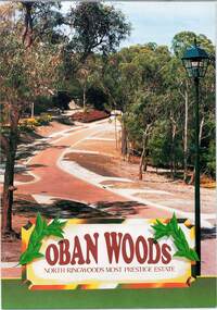 Ringwood and District Historical Society
Document - Land Sale Folder, Oban Woods Subdivision, Ringwood North, Vic., - circa 1997
Folder containing multi-fold colour pamphlet advertising Lots 6 to 12 of Oban Woods Estate with location map and summary of subdivision features. A4 size attachments include subdivision layout of Lots 2 to 25 with summary of property sizes and undated indications of whether sold or still available at the time, with price where known. Dates not documented however early sales within the development took place around 1997.Estate plan includes Oban Woods (thoroughfare) and Chifley Parade. Location map of area shows development site of Oban Woods Estate off Oban Road and Kubis Drive, Ringwood North. Agents - R.E. Appleby Ringwood Pty Ltd., 170 Warrandyte Road Ringwood North 3134, Telephone 9876 4222, Fax 9876 4209. -
 Hume City Civic Collection
Photograph, early 1980s
The Headland Estate housing development began in the early 1980s. It was situated west of Sunbury and was bounded by Elizabeth Drive, Reservoir Road, Phillip Drive and Stewart's Lane.A coloured landscape photograph with rounded corners of a view of Sunbury overlooking the Headland Estate before its development. There is a rocky outcrop on the LHS of the photograph and a lightly timbered area in the middle distance. Sunbury can be seen in the distance.headland estate, mt. holden, sunbury township, george evans collection -
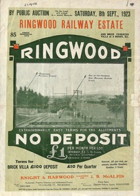 Ringwood and District Historical Society
Flyer, Subdivision Advertisement - Ringwood Railway Estate Public Auction - 1923
Refer also to Reg. No. 5185 for Ringwood Railway Estate final section release (August 1924)Folded double-sided brochure advertising 85 residential allotments and brick cemented villa - Ringwood Railway Estate Public Auction on Saturday 8th September, 1923, with town photographs, location map, terms of sale, and summary of local features and services.Subdivision includes Whitehorse Road, Bon View Avenue, Grant Crescent, Heatherbrae Avenue, Burwood Avenue, and Sherbrooke Avenue. (Agents) Knight & Harwood, 315 Collins Street, Melbourne, Phones Central 10615, 10616, in conjunction with J.B. McAlpin, Opposite Railway Station, Ringwood, Phone Ringwood 7. -
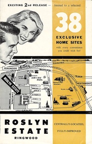 Ringwood and District Historical Society
Flyer, Land Sale Brochure - Roslyn Estate, Ringwood, Vic. - circa 1960s
Land sale advertisement for 2nd release of residential sites with area map, layout of the estate, terms of sale, and summary of local facilities and services.Subdivision includes Daisy Street, Vale Street, Joan Court, Christine Court, and Westmore Drive. (Agent) Heathmont Estate Agency, 103 Canterbury Road, Heathmont. (Phone) WU7808-9. Brochure also includes map with streets marked as "Sold" - Reilly Street, Adrian Court, Daisy Street, Jarma Road, Joel Court, and Ross Court, with comment that "all home sites in the first release have already been sold, and most built on." -
 Deaf Children Australia
Book, Endowment Book 1873 - 1920
Created by the Victorian Deaf & Dumb Institution, this is a record of the estates, bequests, bonds and insurance policies of the VD&DI from 1873 to 1920This is a record of how the VD&DI obtained funds from various sources.Brown leather bound book with red leather on spine under name with marbelled facing pages on front and back covers. Pages are laid out in ledger format and detail estates, bequests, bonds and insurance policies of the V.D.&D.I.Spine: "ENDOWMENT BOOK" in gold stampingdeaf children australia, deaf education, endowment book -
 Warrnambool and District Historical Society Inc.
Document, William Ellis Letters of Administration 1877, 1877
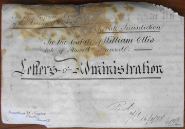
This is an 1877 document, the Letters of Administration in connection with the will and probate of William Ellis, a veterinary surgeon from Wimmera Street, Stawell. He died after an altercation with W. Richards, the landlord of the Post Office Hotel, where he was knocked against the wall of the verandah of the hotel. He left a small estate, with his property valued at under £107. This document is only of interest in that it came from the former legal offices of Mackay Taylor in Kepler Street, Warrnambool. It originally came from Thomas Goodall, a legal clerk in the office of lawyer Ernest Chambers who passed it on to George Mackay, the lawyer in the forerunner firm of Mackay Taylor where it remained until the firm of Mackay Taylor ceased to exist and the buildings were cleaned out. This is a piece of parchment folded and sealed at the bottom edge with a seal of the Supreme Court of the Colony of Victoria. The material in the document is handwritten in black ink. The document is stained and part of it is torn and missing. ‘In the Estate of William Ellis, late of Stawell, deceased, Letters of Administration, 16/8/77, Matthew W. Taylor, Proctor, Stawell’. william ellis,, stawell, warrnambool -
 Kew Historical Society Inc
Plan - Subdivision Plan, Flower Farm Estate, East Kew, 1922
Pru Sanderson, in her groundbreaking ‘City of Kew Urban Conservation Study : Volume 2 - Development History’ (1988), summarised the periods of urban development and subdivisions of land in Kew. The periods that she identified included 1845-1880, 1880-1893, 1893-1921, 1921-1933, 1933-1943, and Post-War Development. These periods were selected as they represented periods of rapid growth or decline in urban development. An obvious starting point for Sanderson’s groupings involved population growth and the associated economic cycles. These cycles also highlighted urban expansion onto land that was predominantly rural, although in other cases it represented the decline and breakup of large estates. A number of the plans in the Kew Historical Society’s collection can also be found in other collections, such as those of the State Library of Victoria and the Boroondara Library Service. A number are however unique to the collection.The Kew Historical Society collection includes almost 100 subdivision plans pertaining to suburbs of the City of Melbourne. Most of these are of Kew, Kew East or Studley Park, although a smaller number are plans of Camberwell, Deepdene, Balwyn and Hawthorn. It is believed that the majority of the plans were gifted to the Society by persons connected with the real estate firm - J. R. Mathers and McMillan, 136 Cotham Road, Kew. The Plans in the collection are rarely in pristine form, being working plans on which the agent would write notes and record lots sold and the prices of these. The subdivision plans are historically significant examples of the growth of urban Melbourne from the beginning of the 20th Century up until the 1980s. A number of the plans are double-sided and often include a photograph on the reverse. The subdivision called the ‘Flower Farm Estate’ in Kew East occurred in 1922. It included 61 lots on either side of Boorool Road between High Street and Harp Road. In an advertisement in The Argus in the same year, the proximity of the estate to the newly erected shops at the corner of Harp Road and High Street is noted. The Flower Farm Estate and similar subdivisions in Kew East were assisted by the extension of the High Street tramline in 1924.subdivision plans - east kew, flower farm estate, high street - kew east (vic.), boorool road -- kew east (vic.), harp road -- kew east (vic.) -
 Kew Historical Society Inc
Plan - Subdivision Plan, Churchill Park Estate, Templestowe
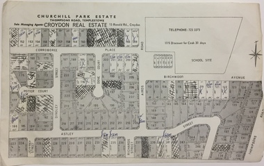
Historic subdivision plan of the Churchill Park Estate in Templestowe.Undated subdivision plan advertising the Churchill Park Estate inTemplestowe. Streets identified in the plan include: Corroboree Place, Astley Street, Jeffrey Street, Airds Road, Dove Court, Potter Court, Thompsons Road, Richards Street, and Birchwood Avenue. This record includes a copy of the price list.Annotations in ink on the plan by agentsubdivision plans - templestowe (vic), churchill park estate - templestowe (vic) -
 Kew Historical Society Inc
Flyer - 45 Pakington Street, Kew
Subdivision plans and real estate flyers/brochures reveal a number of aspects of urban development and history. The Kew Historical Society's collection of these plans, as well as advertisements extracted from magazines, cover key aspects of community development and architectural history of Kew and Kew Eat as well as surrounding suburbs. While most of the plans in the collection were gifted to the Society by the former City of Kew, a number of other plans and advertisements have been donated by individuals, of which this is an example.Single page illustrated real estate flyer advertising 45 Pakington Street, Kew for sale by auction. Annotation in pen and ink at rightpeter neville, real estate advertisements -- kew (vic.), 45 pakington street -- kew (vic.) -
 Kew Historical Society Inc
Photograph - 8 roomed DF Brick Villa, Kew, J E Barnes, c.1920
Subdivision plans are historically important documents used as evidence of the growth of suburbs in Australia. They frequently provide information about when the land was sold on which a built structure was subsequently constructed as well as evidence relating to surveyors and real estate and financial agents. The numerous subdivision plans in the Kew Historical Society's collection represent working documents, ranging from the initial sketches made in planning a subdivision to printed plans on which auctioneers or agents listed the prices for which individual lots were sold. In a number of cases, the reverse of a subdivision plan in the collection includes a photograph of a house that was also for sale by the agent. These photographs provide significant heritage information relating house design and decoration, fencing and household gardens. The photograph is of additional aesthetic significance as it was photographed by J. E. Barnes. Josiah Earl Barnes is a nationally significant photographer. He was also the most important photographer to have worked in Kew. He was active as a photographer in the district from c.1906 until his death in 1921. Best known as 'the Embarkation Photographer' (see the Australian War Memorial collection), J. Earl Barnes was also the official photographer employed by the Borough (and later Town, then City) of Kew. He clearly also completed commercial jobs for local businesses, as is the case in this photograph of a house for a local real estate and financial agent.A photograph, mounted on board of a double fronted Federation-era brick villa in Kew, photographed for a local real estate agent and financier by J. E. Barnes of Kew. On the reverse of the photograph is a subdivision plan for the Normanby Estate, East Kew - 2016.0039.1. As can be seen from the image, there is a large tear on the surface of the photograph.The brown card on which the photograph is mounted includes the following handwritten description, which may aid the identification of the house: "Kew, 3 minutes from tram, 8 roomed DF Brick Villa, tile roof including two attics, sleepout, bathroom, heater, E Light, Entrance Hall, double doors, leadlights, laundry, garden, lawns, land 75 x 170, 1975 pounds". Also photographers inscription on mount, lower left: J. E. Barnes / Photo / Phone 1966 Haw. KEW.j. e. barnes, josiah earl barnes, j. earl banes - photographer, architecture - federation style, houses - kew, real estate photographs -
 Kew Historical Society Inc
Plan - Subdivision Plan, Central Park Estate, Deepdene - Camberwell, 1923
The Kew Historical Society collection includes almost 100 subdivision plans pertaining to suburbs of the City of Melbourne. Most of these are of Kew, Kew East or Studley Park, although a smaller number are plans of Camberwell, Deepdene, Balwyn and Hawthorn. It is believed that the majority of the plans were gifted to the Society by persons connected with the real estate firm - J. R. Mathers and McMillan, 136 Cotham Road, Kew. The Plans in the collection are rarely in pristine form, being working plans on which the agent would write notes and record lots sold and the prices of these. The subdivision plans are historically significant examples of the growth of urban Melbourne from the beginning of the 20th Century up until the 1980s. A number of the plans are double-sided and often include a photograph on the reverse. A number of the latter are by noted photographers such as J.E. Barnes.An agent’s board on which parts of an advertisement for the Central Park Estate have been pasted. [The State Library of Victoria holds a complete plan]. Whereas the original plan included black and white photographs and effusive prose about the virtues of the Estate, the item in our collection includes only the actual blocks. The agent has annotated particular blocks to indicate that they have been sold.subdivision plans - deepdene - camberwell, central park estate -
 Ringwood and District Historical Society
Flyer, Subdivisional Land Sale Brochure, Crown Jewel Estate, Ringwood East, Vic. - c.1925
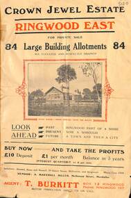
In May 1884, George Smart of Bulleen Road Kew, brickmaker, bought the 23 acres one rood and twenty nine and three tenths perches, or 9.4834 hctares from Arthur Bailey Clements of Ringwood for the sum of 600 pound sterling. (Extract from The Story of the Crown Jewel Estate in Ringwood East pdf)Double sided folded page with black and red print on both sides advertising auction sale of residential and business sites and highlighting local facilities, services and layout of the estate.Subdivision includes Mount Dandenong Road, Valda Avenue, Evon Avenue, Mirabel Avenue, and Velma Grove. (Agent) T. Burkitt, Box 12 Ringwood, Phone Ringwood 157. Vendor: A. Marshall Miller, McDonald Street, Mordialloc. Solicitors: Russell, Bona and Russell, 19 Queen Street Melbourne, and Ringwood - Phone Cent. 4308. -
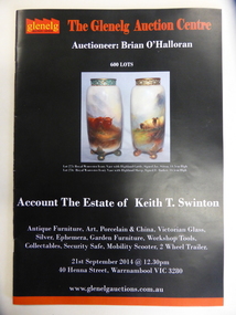 Warrnambool and District Historical Society Inc.
Document, Glenelg Auction catalogue K T Swinton, 2014
This catalogue contains a list of the sale items of Mr Keith T Swinton. The Swinton family are long time residents of Warrnambool the family originally coming from Scotland in 1854 and opening the store in Timor Street Warrnambool. It remains today as one of the longest running family owned businesses in the district. As a general store it stocked groceries china,glass and hardware.. Keith Swinton joined the family firm with his brother Frank in 1934. Much of the original store was relinquished in the 1970's with the furniture section continuing under the Swinton name to this day.This catalogue contains the collection of household items.An interesting item which shows the collection of one of Warrnambool's residentsMainly black soft card cover with red and white text and coloured photograph of a pair of vases.Back cover is black with red line at the top edge with coloured photograph in centre of auction item .18 pages of the catalogue gives a description of the 600 items and estimated price. Inside front and back covers are coloured photgraphs of some of the items for sale.Account the Estate of Keith T Swintonwarrnambool, swinton, keith t swinton -
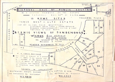 Ringwood and District Historical Society
Flyer - Auction, Mont-Alto Estate, Heathmont, Victoria - circa 1960
Single page advertisement for auction of 13 home sites on Saturday 30th November (1957?) with map of subdivsion, terms of sale, and reference to brick covenant. Subdivision includes Yallamba Place, The Boulevard, and Anne Court, Heathmont. Agents - Heathmont Estate Agency, 103 Canterbury Road, Heathmont (Telephone) WU6808, and C.E. Carter & Son, 126 Whitehorse Road, Ringwood, WU6024. Auctioneer - Mr. A. Carter."This Estate is subject to a covenant that all homes to be erected must be a minimum of 12-1/2 squares and are to be of brick or brick veneer construction, thus ensuring owners of preserving their value for the future." -
 Whitehorse Historical Society Inc.
Pamphlet - Advertising brochure, Arlington Estate
Estate Agent's advertising brochure for Arlington Estate,Estate Agent's advertising brochure for Arlington Estate, Blackburn including Molleton Street. Baldwin Street and Canterbury Road.Estate Agent's advertising brochure for Arlington Estate,arlington estate, blackburn, molleton street, canterbury road, baldwin street, land subdivision -
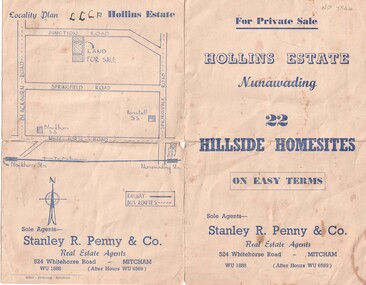 Whitehorse Historical Society Inc.
Document, Hollins Estate, 1955
Private sale of 22 hillside home-sites on Junction Road, Blackburn, called Hollins Estate by Stanley R. Penny & Co., 524 Whitehorse Road, Mitcham.hollins estate, stanley r. penny & co., real estate agents, blackburn, junction road, suto, joyce -
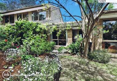 Greensborough Historical Society
Advertising Leaflet, 5 Desmond Court Greensborough, 01/12/2012
5 Desmond Court Greensborough: 4 bedroom brick veneer home, auctioned 1 December 2012, sold for $598,000Real Estate advertising leafletdesmond court greensborough -
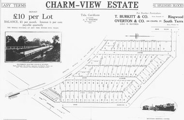 Ringwood and District Historical Society
Photograph, Land sale advertisement for Charm View Estate, Heathmont - 1927
Map - Charm-View EstateTyped below photograph, "From 1927 land subdivision brochure". -
 Kew Historical Society Inc
Plan - Subdivision Plan, Thornton Estate, 1918
The ‘Thornton Estate’ was the final subdivision of ‘Thornton’ in Studley Park Road. Thomas Cubitt Balmain originally owned Thornton, next to John Carson’s ‘Clutha’. Before its final subdivision, the Thomson family owned it. The Estate was a subdivision of 15 residential allotments running between Studley Park Road and Stevenson Street. The allotments faced these streets as well as Thornton Street, which the vendor undertook to make. Contemporary newspaper advertisements advised that ‘The estate possesses many advantages, notably its private and secluded, though convenient, position, splendid frontages and depths, and being close to the electric tram and Kew train, also within easy walking distance of the Victoria-street cable tram’. The terms offered purchasers were ten per cent deposit, with the balance to be paid in ten equal half-yearly payments at a rate of 5 per cent.The ‘Thornton Estate’ was the final subdivision of ‘Thornton’ in Studley Park Road. Thomas Cubitt Balmain originally owned Thornton, next to John Carson’s ‘Clutha’. Before its final subdivision, the Thomson family owned it. The Estate was a subdivision of 15 residential allotments running between Studley Park Road and Stevenson Street. The allotments faced these streets as well as Thornton Street, which the vendor undertook to make. Contemporary newspaper advertisements advised that ‘The estate possesses many advantages, notably its private and secluded, though convenient, position, splendid frontages and depths, and being close to the electric tram and Kew train, also within easy walking distance of the Victoria-street cable tram’. The terms offered purchasers were ten per cent deposit, with the balance to be paid in ten equal half-yearly payments at a rate of 5 per cent.subdivision plans - kew, thornton estate, studley park road -- kew (vic.), thornton avenue -- kew (vic.), stevenson street -- kew (vic.) -
 Ringwood and District Historical Society
Document - Folder, Byways Estate Residential Subdivision, Ringwood East, Victoria 1965-1970
Collection of Subdivision brochures, plans, maps and sales information for sectional releases of Byways Estate.Subdivision plans include: First and second release (1965-66) - Alexandra Road, Isabel Avenue, Byways Drive and Buronga Avenue. Third release (1967) - Byways Drive, Buronga Avenue, Hender Street, Lester Avenue and Jess Court. Fourth and final release (1970) - Hume Street, Walhalla Drive and Hender Street. (Agent) C.E. Carter & Son R.E.S.I. 126 Whitehorse Road, Ringwood, 3134 (Telephone) 870 2519, 870 6830, 870 6024, A.H. 723 3298, 870 4604, 870 6454. Accompanying handwritten sales notes researched in 2024 by Richard Carter - Carter Real Estate - "Vendors - Jessie May Cleland & Alan Cleland of (what became) 4 Bywats Drive. Vendors retired to Buronga near Mildura. Rex was (I think) their son. Jess Court reflects vendor's name. See also History of Byways & Coolooli by Richard Carter in RDHS archives." (Vic Collections RDHS 18023 refers.) -
 Kew Historical Society Inc
Plan - Subdivision Plan, Pointed Firs Estate, 1936
The Kew Historical Society collection includes almost 100 subdivision plans pertaining to suburbs of the City of Melbourne. Most of these are of Kew, Kew East or Studley Park, although a smaller number are plans of Camberwell, Deepdene, Balwyn and Hawthorn. It is believed that the majority of the plans were gifted to the Society by persons connected with the real estate firm - J. R. Mathers and McMillan, 136 Cotham Road, Kew. The Plans in the collection are rarely in pristine form, being working plans on which the agent would write notes and record lots sold and the prices of these. The subdivision plans are historically significant examples of the growth of urban Melbourne from the beginning of the 20th Century up until the 1980s. A number of the plans are double-sided and often include a photograph on the reverse. A number of the latter are by noted photographers such as J.E. Barnes.An almost identical plan of the ‘Pointed Firs Estate’ is in the State Library of Victoria. The plan unusually uses a photograph to show the panoramic views from the Estate. A prospective purchaser could expect to look across the Yarra Valley to Eaglemont and Heidelberg. The 36 lots advertised for sale faced Doncaster Road, Houghton Street, Maud Street and Thackray Street in Balwyn North.subdivision plans - balwyn, pointed firs estate -
 Whitehorse Historical Society Inc.
Map - Civic Map, Subdivision of Village of Springfield, 1861
Map of the subdivision of the Springfield Estate, Nunawading, 1861. The Springfield Estate was located in the Northwest corner of Whitehorse Road and Springvale Road.Map of the subdivision of the Springfield Estate, Nunawading, 1861. Springfield Estate was located in the Northwest corner of Whitehorse Road and Springvale Road.non-fictionMap of the subdivision of the Springfield Estate, Nunawading, 1861. The Springfield Estate was located in the Northwest corner of Whitehorse Road and Springvale Road.springfield estate, whitehorse road nunawading, springvale road nunawading -
Canterbury History Group
Map - Logan Estate, Canterbury
Real estate advertisement distributed by Sinclair & Company of a reproduction of a historical map of the Logan Estate and a short history on the reverse side.canterbury, logan estate, canterbury road, prospect hill road, marlowe street, logan street, canterbury railway station, logan family, sinclair & company, clairmont estate, molesworth street -
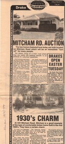 Whitehorse Historical Society Inc.
Newspaper, Mitcham Road auction, 01/04/1984,Nunawading
Advertisement for the sale of two homesAdvertisement for the sale of two homes, 265 Mitcham Road, Mitcham and 534 Mitcham road, Mitcham a 1930s timber home. Agent, drakes real estate. Photographs. Cutting from Nunawading Gazette, 18th April, 1984.Advertisement for the sale of two homesmitcham road, mitcham, no. 534, mitcham road, mitcham, no. 265, houses, drake & co.