Showing 8616 items matching "house building"
-
 City of Moorabbin Historical Society (Operating the Box Cottage Museum)
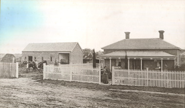
Photograph - 115 Jasper Road, Bentleigh, Allan / Grewer Estate, c. 1890's
... on which is erected a 4 roomed brick house with 2 rooms of wood... roomed brick house with 2 rooms of wood at the rear and stable ...115 Jasper Road, Bentleigh East was a market garden owned by James Allan. In 1880 the property was transferred to David Grewar (Gruar) who had married James' niece Mary Allan. In 1926 part of the land was subdivided and sold as residential blocks. The block with the house pictured remained in the family until 1969. The land now forms part of Our Lady of Sacred Heart College. The description of the land owned by David Kidd Grewer (also spelt Gruar) in 1885: Fourteen acres or thereabouts at the corner of Jasper Road and Patterson’s Road East Brighton being part of Crown Block of 5720 acres Parish of Moorabbin County of Bourke being land comprised in Certificate of Title Volume 1344 Folio 268692 on which is erected a 4 roomed brick house with 2 rooms of wood at the rear and stable and a 2 roomed weatherboard cottage valued as under: 14 acres of land less crops £629.0.0 4 roomed brick house £250.0.0 Other buildings £50.0.0 2 roomed weatherboard cottage £35.0.0 Early pioneer family of the City of Moorabbin.Black and White photo in picture framegrewar, market garden, moorabbin, bentleigh, jasper road, housing, pioneer, james allan, orchard -
 Glen Eira Historical Society
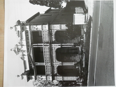
Letter - Lisbon House
... the Historic Buildings Council to owners of the Lisbon House advising... the house in the Historic Buildings Register. Letter dating 31/03 ...Copy of a notification letter from National Trust of Australia to the owner Mrs EM Reeves that Lisbon House been classified. Dated 26/03/1994 Photocopy of conservation study of Lisbon House by Andrew Ward in October 1994. Includes brief description and history and photograph of the house. Letter from the Historic Buildings Council to owners of the Lisbon House advising on the application to review and include the house in the Historic Buildings Register. Letter dating 31/03/1995. Letter dated 18/09/1995 from the HBC to the owners of the house advising them that the house will not be added to the register. One page description of Lisbon House with sketch of facade. Date and source unknown. Photograph of Lisbon House. Date unknown, black and white, photographer unknown.reeves e m, hart t, ward andrew, brown mary, brown walter, weigall reginald, brown em, mould arthur, symons george, read m, tonkin ray, kons a&a, caulfield, elsternwick, orrong road, lisbon house, glenhuntly road, city of glen eira, verandahs, cast iron work, architectural styles, italianate style, victorian style, caulfield historical society, caulfield north -
 Federation University Historical Collection
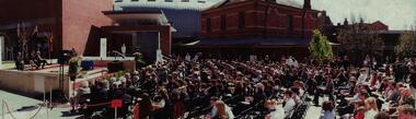
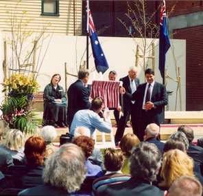
Photograph - Colour, Steve Bracks, Premier of Victoria, opens the University of Ballarat Arts Academy, Camp Street, 22/07/2008
... the importance of maintaining the heritage buildings and the opportunity... buildings have been constructed. These six buildings will house ...The University of Ballarat inherited the Camp Street Arts Precinct. As the functions of the former public buildings were moved elsewhere, the Victorian Government of the time recognised the importance of maintaining the heritage buildings and the opportunity to create a cultural precinct extending from the Art Gallery. The 19th century architecture along Lydiard Street and the dogleg bend of Camp Street define the precinct. With substantial financial assistance from both State and Commonwealth Governments, the Art Gallery Ballarat has been extended through to include the 1884 Police Station on Camp Street. The Post Office building (1864-1887) was acquired for the University. The 1904 and 1941 Courthouses and the c1900 Public Library building were also included. Two new buildings have been constructed. These six buildings will house the University's Visual and Performing Arts Programs.3 Panorama photograph of the opening of the University of Ballarat Arts Academy, Camp Street. .2 Poster .1) L to R Kerry Cox (Vice Chancellor); Brendan Nelson (Federal Minister - Education); Chancellor David Caro; Steve Bracks, Premier of Victoria. Photographer Ian Reiduniversity of ballarat, camp street, victorian government, commonwealth government, ballarat fine art gallery, police station, courthouse, public library, post office, art gallery ballarat -
 Wodonga & District Historical Society Inc
Photograph - Codling Collection 01 - Wodonga's First Court House
... court house was a timber building constructed in 1859... of the building. Codling Collection 01 - Wodonga's First Court House ...Miss Olive Codling was a Foundation Member and a Life Member of the Wodonga Historical Society. Many of her prize-winning photos are held in the Society Collection. She also held a range of roles and committee positions in a wide range of Wodonga community organisations. COURT HOUSE - Wodonga's first court house was a timber building constructed in 1859. In January 1877, a contract was let to add the brick building to the existing structure. This court house opened in June 1877. This gabled court house was designed by architect Peter Kerr and was constructed at a cost of £1,325. It served as the court house until it was replaced in 1920. It was then used as a private residence for many years. At various stages it was also operated as a restaurant, a real estate agency, an antique shop and currently operates as commercial offices.This photo collection is significant as it documents how the businesses and buildings in Wodonga have evolved and contributed to community throughout the 20th century.A black and white image of the original Court House and Police paddock. Also an image of the "Court" sign, a view of the back of the building and a present day colour image of the building.wodonga businesses, high st wodonga, wodonga court house -
 Port Melbourne Historical & Preservation Society
Photograph - Exterior views, J Kitchen & Sons, Port Melbourne, 2011 - 2014
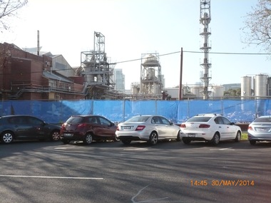
... housed the factory outlet shop. Admin building in background... housed the factory outlet shop. Admin building in background ...External views of the J Kitchen & Sons site. Some taken October 2011 when manufacturing still occurred on site and some in May 2014 after demoltion work had begun to clear the site for future development; (.01) The Australian Academy of design building at 220 Ingles St (October 2011) (.02) The building which housed the factory outlet shop. Admin building in background. (October 2011) (.03) Part of the Iindustrial complex surrounded by fence in preparation for demolition. (May 2014) (.04) View of the art-deco admin building taken from Ingles St (May 2014) (.05) Corner of the complex already cleared (former shop outlet) (May 2014)built environment - industrial, business and traders - soaps/candles, j kitchen & sons pty ltd, australian academy of design, ingles street -
 Bendigo Historical Society Inc.
Document - LONG GULLY HISTORY GROUP COLLECTION: A VICTORIAN DREAM HOME
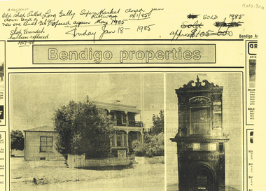
... obscuring the house and a single story weatherboard building beside... for four generations. The house and the building materials ...BHS CollectionPhotocopy of a newspaper article titled A Victorian dream-home by Richard Foord. The article is an estate agent, Craig Tweed & Co Pty Ltd, ad about a house called Kilhallen which had been in the Truscott family for four generations. The house and the building materials are described. A photo shows the back of the two story house with a small room added on at the back. On the back of the page titled Bendigo properties is a photo of a two story house with ironlace on the verandas, a tree partly obscuring the house and a single story weatherboard building beside it. An auction sale sign is on the front fence. The second photo shows an ornate fireplace with tall carving above it. Written at the top of the page is: A Truscott. Old shop pulled down and a new one built Feb 90. Shop verandah has been replaced 1987-88. Long Gully Super Market Riteway Jan 14/1/85. opened again May 1985. Friday Jan 18 1985. Sold 1985.bendigo, history, long gully history group, the long gully history group - a victorian dream home, richard foord, anthony truscott, kilhallen, craig tweed & co pty ltd -
 Kew Historical Society Inc
Photograph - 'Carronbank', Marshall Avenue, 1980s
... the period 1961 to c.1980, the building housed a number of services....1980, the building housed a number of services. From 1969 ...Carronbank (demolished) in Marshall Avenue, Kew was once the home of the Rev Graham Henty Balfour. It had extensive grounds, including a tennis court at the rear of the property. It remained a private residence until c.1960. The Department of Education purchased Carronbank as a school for partially sighted children, opening in February 1961 as State School No 4483. During the period 1961 to c.1980, the building housed a number of services. From 1969 to 1974, it was the site of Carronbank State School, later renamed Carronbank School for Deaf-Blind Children. In 1973, the Department established the Visiting Teacher Service for the Visually Impaired at the site. Its aim was to support teachers working in Victorian Government, Catholic and Independent Schools. From 1983 the school operated as Statewide Resource Centre for Visiting Teachers of the Vision Impaired. In 1988, the amalgamation of Princess Elizabeth Junior School for Deaf Children, the Monnington Centre and Carronbank School for Deaf Blind Students allowed the Victorian Government to sell each of the sites. Monnington [Adeney Avenue, Kew] reverted to private ownership, while Glendonald and Carronbank in Marshall Avenue were demolished and subdivided.The donor, Mr Murray Osler, was Principal of the Monnington Special Education Centre in Adeney Avenue (Kew) from 1976. This photo, and an accompanying drawing of 'Monnington' are important primary resources for the delivery of education to and for deaf-blind children in Victoria.The photograph, framed under perspex, shows the tennis court of Carronbank which had been converted into a play area for the students of the school. The flat roofed building may have been a toilet block, added for the school. The garage brick wall belongs to No 11. Grass is growing on the original asphalt court and there is equipment and tunnels for play. When sold the property was divided into three separate building blocks.carronbank -- marshall avenue -- kew (vic.), schools -- kew (vic.), carronbank -
 Ballarat Heritage Services
Photograph - Digital photograph, Nose in Admiralty Arch, London, 19/09/2016
... , the building housed government offices, but in 2012 the government sold..., the building housed government offices, but in 2012 the government sold ...Admiralty Arch is a landmark building in London which incorporates an archway providing road and pedestrian access between The Mall, which extends to the southwest, and Trafalgar Square to the northeast. Admiralty Arch, commissioned by King Edward VII in memory of his mother, Queen Victoria and designed by Aston Webb is now a Grade I listed building. In the past, it served as residence of the First Sea Lord and was used by the Admiralty. Until 2011, the building housed government offices, but in 2012 the government sold a 125-year lease over the building to a property developer (Prime Investors Capital, run by Rafael Serrano) for redevelopment into a luxury hotel, restaurant and apartments. (Wikipedia) On the inside wall of the northernmost arch is a small protrusion the size and shape of a human nose. It was placed there by artist Rick Buckley in 1997 as part of a campaign against the "Big Brother" society. The nose is at a height of about seven feet, and sits at waist height for anyone riding through the arch on a horse. Prior to Buckley being unmasked in 2011 by the London Evening Standard, an urban myth grew that the nose is there in honour of the Duke of Wellington, who was known for having a particularly large nose.(wikipedia)admiralty arch, london, nose -
 Federation University Historical Collection
Photograph - Photograph - Colour, Ian Reid, Steve Bracks, Premier of Victoria, opens the University of Ballarat Arts Academy, Camp Street, 22/07/2008
... buildings have been constructed. These six buildings will house... constructed. These six buildings will house the University's Visual ...The University of Ballarat (later Federation University_ inherited the Camp Street Arts Precinct. As the functions of the former public buildings were moved elsewhere, the Victorian Government of the time recognised the importance of maintaining the heritage buildings and the opportunity to create a cultural precinct extending from the Art Gallery. The 19th century architecture along Lydiard Street and the dogleg bend of Camp Street define the precinct. With substantial financial assistance from both State and Commonwealth Governments, the Art Gallery Ballarat has been extended through to include the 1884 Police Station on Camp Street. The Post Office building (1864-1887) was acquired for the University. The 1904 and 1941 Courthouses and the c1900 Public Library building were also included. Two new buildings have been constructed. These six buildings will house the University's Visual and Performing Arts ProgramsColoured postcard size photograph of Steve Bracks, Premier of Victoria, unveiling the plaque at the opening of the University of Ballarat Arts Academy, Camp Street. .1) L to R Kerry Cox (Vice Chancellor); Brendan Nelson (Federal Minister - Education); Chancellor David Caro; Steve Bracks, Premier of Victoria. Photographer Ian Reiduniversity of ballarat, camp street, victorian government, commonwealth government, ballarat fine art gallery, police station, courthouse, public library, post office, art gallery ballarat, art gallery of ballarat -
 Eltham District Historical Society Inc
Photograph, Liz Pidgeon, Heritage Excursion; The 1901 Eltham Railway Walk, 3 May 2014, 3 May 2014
... alignment and for some distance each side. The plans show houses... alignment and for some distance each side. The plans show houses ...Newsletter No. 216, May 2014 May Excursion – The 1901 Eltham Railway Walk The railway from Heidelberg to Eltham was opened in 1902. Over the previous year railway construction cut a curving swathe through Josiah Holloway’s 1851 Little Eltham subdivision. The survey plans for the railway show the owners and occupiers of land within Little Eltham affected by the railway alignment and for some distance each side. The plans show houses and other buildings but development at that time was rather sparse. Copies of these plans from the State Library of Victoria collection have been provided to the Society by Alan Sheehan. For our walk on 3rd May we intend to follow the railway from the Eltham Station to Ryans Road, which was the boundary of the adjoining Montmorency Farm. The return will be by way of nearby streets. Along the way we will discuss the details shown on the railway plans as well as more recent railway documents and photographs. At the conclusion and if time permits we can inspect the historical display at the Eltham Station. The walk is about 3 km in length and will take about 2.5 hours. It will start at 2 pm at the Eltham Railway Station car park (east/Main Road side) (Melway Ref. 21 J5).Born Digitalheritage excursion, activities, eltham district historical society, eltham railway station, eltham library, trestle bridge -
 Eltham District Historical Society Inc
Negative - Photograph, Popular Picnicing at Hurstbridge, c.1925
... like Dorset House. The building on the left in the middle... like Dorset House. The building on the left in the middle ...Picnickers enjoying a Sunday outing near the Wattle Valley Estate at Hurstbridge. Copied from brochure "Wattle Valley Estate". It is believed the picture is taken at the northwest corner of the intersection of Wattletree Road and Hurstbridge-Arthurs Creek Road looking southeast towards the township (most likely where the house is located on the property of what is today No. 2 Wattletree Road)- https://goo.gl/maps/VDorwCe1rJJUapjE6 According to a comment by Jean Verso (via @nillumbikcouncil FB page 3 Jan 2020) - "This view is from Wattle Tree Road with Haleys Gully Road to the right and across the creek to William Gray's nursery at Allwood. The building to the far left looks like Dorset House. The building on the left in the middle distance is still there today and has been used for storage and as a stable/tack room for a number of years." The Wattle Valley Estate was first advertised in August 1925 as weekend building allotments by the Greater Melbourne Land and Development Company. Advertised from £28.10.0 or £60 per block. In August 1926, 30 picked allotments of 60x150 feet were put up for auction Saturday August 14, 1926 with frontages to Valley View Road and Fawkner Crescent advertised in the “Heart of the Glorious Wattle Country” and “Within 15 Minutes of the Newly Electrified Railway Station”. The Advertiser on August 13, 1926 in an article promoting the auction stated “the estate is regarded as one of the best in the district, and will be sold practically without reserve.” It is noted that an advertisement running in The Argus February 22, 1951 offered the remaining 16 blocks for sale at £12.10.0 or £200 the lot. By March 7, the remaining blocks were advertised at £17.10.0 The Wattle Valley Estate took over 20 years to sell and then people could not build on them Cross Ref EDHS_02665 Rose Series Postcard P. 4341, "View at Hurstbridge, Vic." Also, other images from sales brochure SEPP_1055 / 1056This photo forms part of a collection of photographs gathered by the Shire of Eltham for their centenary project book,"Pioneers and Painters: 100 years of the Shire of Eltham" by Alan Marshall (1971). The collection of over 500 images is held in partnership between Eltham District Historical Society and Yarra Plenty Regional Library (Eltham Library) and is now formally known as the 'The Shire of Eltham Pioneers Photograph Collection.' It is significant in being the first community sourced collection representing the places and people of the Shire's first one hundred years.Digital image 4 x 5 inch B&W Neg1925, dorset house, fawkner crescent, haleys gully road, hurstbridge, hurstbridge-arthurs creek road, picnic, postcards, shire of eltham pioneers photograph collection, valley view road, wattle valley estate, wattletree road, exhibition yprl 2019-12 -
 Eltham District Historical Society Inc
Photograph - Postcard, Rose Stereograph Company, View at Hurstbridge, Vic, c.1925
... . The building to the far left looks like Dorset House. The building.... The building to the far left looks like Dorset House. The building ...Rose Series Postcard P. 4341 “View at Hurstbridge, Vic.” Picnickers enjoying a Sunday outing near the Wattle Valley Estate at Hurstbridge. Copied from brochure "Wattle Valley Estate". It is believed the picture is taken at the northwest corner of the intersection of Wattletree Road and Hurstbridge-Arthurs Creek Road looking southeast towards the township (most likely where the house is located on the property of what is today No. 2 Wattletree Road)- https://goo.gl/maps/VDorwCe1rJJUapjE6 According to a comment by Jean Verso (via @nillumbikcouncil FB page 3 Jan 2020) - "This view is from Wattle Tree Road with Haleys Gully Road to the right and across the creek to William Gray's nursery at Allwood. The building to the far left looks like Dorset House. The building on the left in the middle distance is still there today and has been used for storage and as a stable/tack room for a number of years." The Wattle Valley Estate was first advertised in August 1925 as weekend building allotments by the Greater Melbourne Land and Development Company. Advertised from £28.10.0 or £60 per block. In August 1926, 30 picked allotments of 60x150 feet were put up for auction Saturday August 14, 1926 with frontages to Valley View Road and Fawkner Crescent advertised in the “Heart of the Glorious Wattle Country” and “Within 15 Minutes of the Newly Electrified Railway Station”. The Advertiser on August 13, 1926 in an article promoting the auction stated “the estate is regarded as one of the best in the district, and will be sold practically without reserve.” It is noted that an advertisement running in The Argus February 22, 1951 offered the remaining 16 blocks for sale at £12.10.0 or £200 the lot. By March 7, the remaining blocks were advertised at £17.10.0 The Wattle Valley Estate took over 20 years to sell and then people could not build on them Cross Ref SEPP_1057, “Popular Picnicing at Hurstbridge” rcopied from Wattle Valley estate sales brochure.Digital file only Postcards scanned from the collection of Michael Aitken on loan to EDHS, 13 Feb 20181925, dorset house, exhibition yprl 2019-12, fawkner crescent, haleys gully road, hurstbridge, hurstbridge-arthurs creek road, michael aitken collection, picnic, postcards, rose stereograph company, shire of eltham pioneers photograph collection, valley view road, wattle valley estate, wattletree road