Showing 693 items
matching measurement
-
 Bendigo Historical Society Inc.
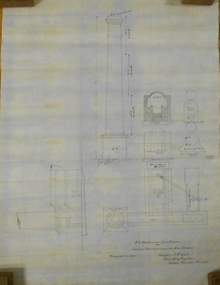
Plan - MARKS COLLECTION: PLAN EXTRA BOILER LANSELL'S 180 MINE
Engineering drawings for the (written on bottom of plan) 'No 2-arrangement extra boiler for Lansells Proprietary little 180 Mine Bendigo Plan shows chimney - side elevation, measurements of chimney, flue, boiler (and existing boiler, existing loco boiler) On bottom of plan: Scale 1/4 inch = 1 foot. Hargreaves & Daggar, Consulting Engineers, Victoria Chambers, Bendigo.mining, equipment, lansell's little 180 mine -
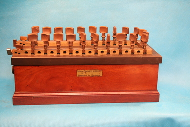 The Ed Muirhead Physics Museum
Resistance box
Wooden box with brass top and 24 knobs (22 larger and 2 smaller) on the right-hand side. In addition there are two extra knobs on the right side of the top, as well as two removable oval access panels with handles on each of the ends.Stamped on top of box: a coat of arms 'HARTMANN OF BRAUN A/M' 'RICHTIG BEI / 20 / GRAD CELSIUS' increments for measurement On front side: Sticker labelled 'NATURAL PHILOSOPHY LABORATORY / NO 7 / UNIVERSITY OF MELBOURNE' Stamped on end of metal top: 'No. 2665'hartmann of braun, resitance decade box, resistance box, electical instruments, frankfurt, natural philosophy laboratory -
 City of Greater Bendigo - Civic Collection
Instrument - Gunter Chain, not known
Gunter's chain (also known as Gunter’s measurement) is a distance measuring device used for surveying. It was designed and introduced in 1620 by English clergyman and mathematician Edmund Gunter (1581–1626). It enabled plots of land to be accurately surveyed and plotted, for legal and commercial purposes. The provenance of this particular Gunter Chain is unknown but it is believed to be used either by the City of Bendigo / Sandhurst or the Lands Department locally when measuring and laying out plots and streets locally. A 66-foot (20.1 m) chain divided into 100 links, marked off into groups of 10 by brass rings or tags. Each link is 7.92 inches (201 mm) long. A quarter chain, or 25 links, measures 16 feet 6 inches (5.03 m) also called a a rod (or pole) measure. Ten chains measure a furlong and 80 chains measure a statute mile. city of greater bendigo surveying -
 Department of Energy, Environment and Climate Action
Planimeter (roller digital)
The rollers move over the map as the tracing arm is used to follow the boundary to be measured. The wheels allow unlimited horizontal travel and vertical travel within the limits of the arm movement. They measure in the X and Y directions Reading from the digital scale the area in square centimetres could be measured. Knowing the scale of the mapsheet the figure was converted to areas or hectares Generally at least three measurements were taken to ensure accuracy and precisionPlanimeter used to measure areas from scale maps. Includes box but no charger Plancom KP90forests commission victoria (fcv), forest measurement, surveying -
 Frankston RSL Sub Branch
Memorabilia - Level, Abney
Square gunsight telescope.An Abney level and clinometer, is an instrument used in surveying which consists of a fixed sighting tube, a movable spirit level that is connected to a pointing arm, and a protractor scale. An internal mirror allows the user to see the bubble in the level while sighting a distant target. It can be used as a hand-held instrument or mounted on a Jacob's staff for more precise measurement, and it is small enough to carry in a coat pocket -
Glenelg Shire Council Cultural Collection
Photograph - Sheet of 2 black and white contact prints from glass plate negatives, 1960-1970
Sheet of 2 black and white contact prints from glass plate negatives. Measurements are 11.8 x 16.1 cm for both prints. Top: Image of stone house with shingle roof and stone chimneys. Veranda with iron support poles and lacework. Vines growing up poles. (same house as 5622) Front view. Bottom: Man on horse. Cypress pines, wooden fence behind. -
 Orbost & District Historical Society
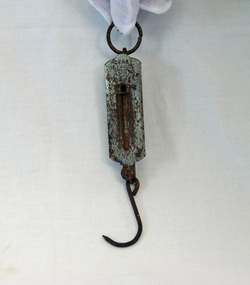
pocket scales, 1920's
The pocket balance was first created in 1770 by Richard Salter in the UK. From the late 18th century onwards these small scales were widely used in markets, grocers and farm shops – wherever people needed to be able to verify the weight of goods to be purchased in order to calculate the correct pricing. Because it was portable, and simple to use, the pocket balance was ideal for weighing goods where accuracy was not required. This balance appears to have been used for weighing fish.Pocket spring scales made of steel. There is a spring fixed at one end with a hook to which an object can be attached at the other. At the top of the scales there. is a metallic ring to fasten the object. This is attached to the main body which on one side has measurements inscribed into the metal surface. Inside the body is a spring loaded mechanism which moves along the scales when weight is added to a hook at the bottom of the shaft.At the top - POCKET BALANCE ARROW and the letters M P inside an oval.scales pocket-balance spring-balance measuring-instrument -
 Kew Historical Society Inc
Plan - Subdivision Plan, J Hurrey, Section 115 in the Parish of Boroondara Near Richmond Bridge, 1853
Despite the plans claims that it is a subdivision near the Richmond Bridge, Section 115 was located at what is now Camberwell Junction. While the plan only lists government roads rather than named streets, the section was located on the east side of Burke Road, stretching up the hill from the current Junction. Research on Trove, conducted by Kerry Fairbank, discovered an advertisement for unsold lots in Section 115 which clarifies the extent and location of subsequent land sales in the original section. The original article can be viewed through the link in the catalogue record. The interesting link to Kew is the reference to James Beavan as the purchaser of lots 14 and 15. The historian Gwen McWilliam has notes that a Mr Beavan changed his name from Bevan. The Bevans were descendants of the Derricks family of Kew. This subdivision plan is the earliest original map or plan in the collection which shows parts of what is now the City of Boroondara, dating from circa 1853. It provides important information for researchers on subsequent subdivisions following the original land sales in [Camberwell] Boroondara. The site, on the east side of Burke Road is a highly-significant and historic site. This is believed to be the only extant copy of the subdivision in public collections.A small plan on parchment listing 28 lots, between one and two acres each, for sale in Section 115 in the Parish of Boroondara, dating from 1853 when the portion was subdivided.Obverse: Lot 16 "Joseph Duval", Lots 14 & 15 "James Beavan". Other annotations (measurements) are unreadable. Reverse: "KH-981 / Section 115 in the Parish of Boroondara / Near Richmond Bridge / 1640T. / J Duval / 14-15 J. Beavanparish of boroondara, subdivision plans - camberwell, section 115 - boroondara, subdivision plans -- camberwell (vic), riverscape road, burke road, camberwell junction -
 National Wool Museum
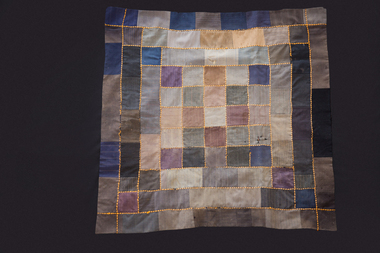
Textile - Quilt, Mrs Elizabeth Morton, c.1934
Made by Mrs Noel (Lizzie) Morton, the donor's mother on their farm "Wanera" at Benjeroop on the Murray River. It was stitched with a treadle machine. Her sister Flora MacDonald did the running stitch and provided the silk backing. The squares were sent as samples from a firm called "Fred Hesse" who advertised in the Melbourne papers "Be smart and dressy In a suit by Fred Hesse". The buyer chose a sample and then sent it back with measurements and received a "mail order" suit.A small knee rug made from suiting samples machine stitched together. It is backed with black silk fabric and finished with a running stitch of orange wool oversewn with black wool thread.farming quilting quilting - history, wanera benjeroop, farming, quilting, quilting - history -
Glenelg Shire Council Cultural Collection
Photograph - Sheet of 6 contact prints - Various Historic Portland buildings and landmarks, c. 1970
Sheet of 6 contact prints of rephotographed photographs: Identifying numbers 5709 a,b,c,d,e,f Measurements a,b, c, d, e, f,5 x 3.55 x 1.5 cm a. Harbour from Post Office b. Bridge in Gardens c. Gardens Cottage d. Yankee Doodle Corner e. Cape Nelson Road to Bentinck Street f. Percy Street -
 4th/19th Prince of Wales's Light Horse Regiment Unit History Room
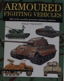
Book, Philip Trewhitt: Armoured Fighting Vehicles, 300 of the world's greatest military vehicles, 2000 (exact); Reprinted 2001, 2002, 2003, 2004
A compendium of of the most important and influential military vehicles that have been in service since World War 1. Each vehicle featured is illustrated by a full-colour side-profile artwork, and accompanied by a detailed specifications table giving country of origin, crew, weight, dimensions, armour, armament, powerplant and performance, all measurements in imperial and metric. Accompanying text for each vehicle summarises its development and service history.ISBN 1-84013-338-4world war 1, world war 2, military history, tanks, armour, armoured fighting vehicles, wheeled infantry vehicles, anti aircraft guns, military vehicles, philip trewhitt, world war 1, world war 2, military history, tanks, armour, armoured fighting vehicles, wheeled infantry vehicles, anti aircraft guns, military vehicles, philip trewhitt -
 Warrnambool and District Historical Society Inc.
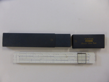
Instruments, Slide Rule, C1955
A slide rule is an instrument which is used to carry out mathematical calculations. William Oughtred is credited with its invention in 1621, however many others including Isaac Newton have made improvements or modifications over the years. From 1625 to 1800 there were approximately 40 different styles brought forward. with the following 100 years sees over 250 designs created.There have been different versions and modifications to suit scientific, mathematical and engineering requirements. It is interesting to note that many of the buildings of the 19th and 20th centuries have been designed with the use of slide rules. Their use has declined in the last 25-30 years with the advent of computers and specialist calculators.While not directly linked in any way to the history of Warrnambool, this slide rule would have been a item in use by students doing maths at upper secondary level as well as other applications which would make it a familiar object to many people.Coated bamboo with sliding metal framed glass panel or cursor . The bamboo is in three sections with the middle section movable. It is marked in various graduated measurements mainly in dark blue but with some in green and red.It is inside a dark grey rectangular box with a slide off lid on one end.There is a celluloid panel on the back with a conversion table printed on it. There is an accompanying 67 page manual with a pale green cover with black text. On slide rule:Sun Hemmi Japan No 2664S On box: Sun Hemmi Japan No 2664S warrnambool, hemmi slide rule, bamboo slide rule -
 Bendigo Historical Society Inc.
Document - STATE RIVERS AND WATER SUPPLY COMMISSION : THE COLIBAN SYSTEM OF WATERWORKS, July
Document titled State Rivers and Water Supply Commission: The Coliban System of Waterworks. Two typed foolscap pages. Three copies of this document - one with measurements in acre-feet, has 'seen July 1971' written in pencil on the top right corner. The other two copies appear to have been updated to convey information in mega litres. Subheadings: History, Development of main storages, Facts and figures, Headworks.state infrastructure, water supply, coliban system, state rivers and water supply commission. coliban system. -
 Melbourne Tram Museum
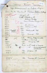
Document - Research Notes, Mr. Mainwaring, PMTT surface slopes, 1910
Three ruled foolscap sheets, tied in the top left hand corner with string, headed Prahran Malvern Tramways - tape measurement of surface slopes from High Street, Glenferrie Road Wattle tree Road to Burke Road. Prepared by Mr Mainwaring in black and red ink. Dated 30.6.1910. Items 2041 to 2052 within box 72.3 in a brown folder marked "PMTT" in red pencil.trams, tramways, pmtt, malvern, surveys, high st, wattle tree rd, burke rd -
 Old Colonists' Association of Ballarat Inc.
Photograph, Dining under the replica Eureka Flag at the Ballarat Old Colonists' Hall, 2017, 23/03/2017
The Eureka Flag hanging in the Old Colonists' Hall is an exact replica of the Eureka Flag that flew over the Eureka Stockade. It was copied from the original flag that was in the possession of the Art Gallery of Ballarat. Exact measurements were taken from the flag and the replica made by the Ballarat firm George Lemke and Co. It was decided to made the replica because of the fragile condition of the original flag. At the time the original flag was beyond being displayed and it was felt steps should be taken to obtain a copy before it deteriorated further. Colour photograph pf a set table, with a replica Eureka Flag on the wall.ballarat old colonists' club, entrance hall, eureka flag, george lemke -
 Bendigo Historical Society Inc.
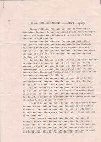
Document - RESEARCH PAPERS: THOMAS WILKINSON PINNIGER, 1828
Thomas Pinniger (1828-1927) was born in England and emigrated to New Zealand before coming to Australia in 1852. With a team of 4 he conducted the first geodetic* survey of Victoria. He became the Government Surveyor for Bendigo in 1853 and in 1854 he laid out the plans for the town of Broadford. His son George, became the Victorian Surveyor General 1925-6. * Large scale mapping based on global measurements of large land masses. It allows corrections for the curvature of the earth.Document detailing the history of district serveyor Thomas Wilkinson Pinniger and his family history. -
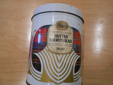 Surrey Hills Historical Society Collection
Container - Biscuit tin, Mac's Butter Shortbread tin
Mac's Shortbread Co dates its history back to a family bakery in Abbotsford opened in the 1860's producing bread for the goldfields. This eventually became McAlpine's Flour. This business was sold in 1960 and the family then purchased a cake shop, leading to building a biscuit factory. (This is thought to have been the Surrey Hills site). The company outgrew this and moved to 5 Tate Drive, Kerang. (Further research required.) Australia adopted metric units of measurement in July 1974, so this object was manufactured after 1974.This tin is material evidence of the small area of industrial activities that once existed in Surrey Hills.A cylindrical tin with a silvered interior and the outside finished in a white enamel paint, on which there is a geometric design incorporating a butterfly.On a label incorporated in the design: "Mac's / MAC'S SHORTBREAD CO. 1 NORFOLK RD./ SURREY HILLS, VIC. AUST. 3127 - 8360333 / BUTTER / SHORTBREAD / INGREDIENTS: WHEAT FLOUR, CHOICE BUTTER, / SUGAR, EVAPORATED MILK, BAKING POWDER / 300 g NET"bakeries, surrey hills, mac's shortbread, norfolk road -
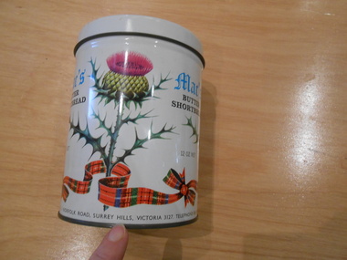 Surrey Hills Historical Society Collection
Container - Biscuit tin, Mac's Butter Shortbread tin
Mac's Shortbread Co dates its history back to a family bakery in Abbotsford opened in the 1860's producing bread for the goldfields. This eventually became McAlpine's Flour. This business was sold in 1960 and the family then purchased a cake shop, leading to building a biscuit factory. (This is thought to have been the Surrey Hills site). The company outgrew this and moved to 5 Tate Drive, Kerang. (Further research required.) Australia adopted metric units of measurement in July 1974, so this object predates 1974.This tin is material evidence of the small area of industrial activities that once existed in Surrey Hills.A cylindrical tin with a silvered interior and the outside finished in a white enamel paint, on which are 3 thistles and a tartan ribbon. 1. Mac's / BUTTER SHORTBREAD / 12 OZ NET 2. MAC'S SHORTBREAD CO., 1 NORFOLK ROAD, SURREY HILLS, VICTORIA 3127. TELEPHONE 836 0333bakeries, surrey hills, mac's shortbread, norfolk road -
Bendigo Historical Society Inc.
Map - UNDERGROUND SECTION OF 3 MINES
Underground section of three mines - Shaft No 94, New Chum United Co, Cross Section No 89 - Shaft No 93, Lansell's 222 (DENIS), Cross Section No 87 - Shaft No 92A (New Shaft), Lansell's 222, Cross Section No 86. Map shows depth of cross sections below the sill and stone encountered. Poppet legs are drawn at the top of the shafts. Lansell's 222 Shaft No 92A has measurements pencilled in.mining, parish map, new chum united, lansell's 222 (denis), lansell's 222 -
Glen Eira Historical Society
Map - Gardenvale Road, 11, Caulfield South
A one page typed letter from Equity Trustees to S P Simmonds Estate Agent, dated 12/12/1963, requesting a valuation of the property at 11 Gardenvale Road, Caulfield South. The file also includes a three page typed valuation of the property dated 19/12/1963. It provides details of the property and includes a hand drawn plan (75mm x 100mm) showing measurements of the block. The file also includes one page of undated, unattributed, handwritten working notes for the purpose of the valuation.redapple r r, redapple joseph, redapple rebecca rachel, gardenvale road, caulfield south, land values, brick houses -
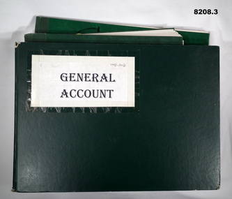 Bendigo Military Museum
Financial record - ACCOUNT BOOKS BRSL, Bendigo RSL Sub Branch, 1983 - 2003
General Account Income/Expenditure books for the Bendigo RSL Sub Branch which flow on into the early years of Bendigo District RSL Sub Branch Inc. .1) For the years 1983 - 1988. .2) For the years 1989 - 1996. Front cover in texta says "1997" .3) For the years 1998 - 2003. Refer Cat No's 8020 & 8073P for the formation of Bendigo District RSL Sub Branch Inc .1) Book, green covers, blue ruled lines with red and blue vertical lines, entries in blue pen, a small amount in black pencil. .1) Book, green covers, blue ruled lines with red and blue vertical lines, entries are in blue pen and black pencil. .3) Book, green covers, blue ruled lines with blue and black vertical lines, entries are in blue pen and black pencil. Measurements are an average of the three..1) On front cover in black texta pen, "General A/C 83 - 88". Printed in gold, "Analysis Book Collins 800 series" .2) On front cover in black texta, "1989 - 1997". Printed in gold same as .1) .3) On front cover pasted on a sheet of white paper with typed, "GENERAL ACCOUNT", in pencil on, "1998 - 2003"brsl, smirsl, accounts -
Glenelg Shire Council Cultural Collection
Photograph - Sheet of two black and white contact prints from glass plate negatives, 1960-1970
Sheet of two black and white contact prints from glass plate negatives. Measurements 12.9 x 16.1cm each print Top Image: 3 women and a man sitting on ground under trees. Tablecloth with picnic food and drink. Bottom Image: Group of men and women, flat rocks Bridgewater Beach. One man has fishing rod. Estimated by the style of the Dress to be taken in the late 19th, early 20th century. -
Glenelg Shire Council Cultural Collection
Medal - Commemorative Medal - The Lady Nelson Bicentenary Medallion, n.d
port of portland -
Glenelg Shire Council Cultural Collection
Mixed media - INVITATION / PROGRAMME, n.d
Identification numbers 8029 a,b,c a. Invitation to afternoon tea to mark retirement of Mr. C.? Campbell from the Vic. Education Department, on Wed. 14 July, 1971. White card, black print b. Program for retirement dinner in (a) White card, deckled edge, black hand print on front. White paper insert, black type. c. Ticket for above dinner, cobalt blue card, black print - No measurements recorded for item c.Front: c. 'Miss Vivian' - hand written, blue biro -
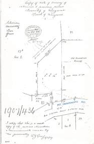 Ringwood and District Historical Society
Document - Copy of Lands Department Field Notes - Survey of Extension to Recreation Reserve, Township of Ringwood, Victoria, Field Notes 1907/436 - Part of O.P. R72D Surveyed 6.8.1907
Foolscap size photocopy of survey map with handwritten notations. References include New Lilydale Road 3 chains wide (Mount Dandenong Road), Silurian, undulating, poor grass, Corner cut off to allow for road in future subdivision, Old recreation reserve, (circled area) oval now in use, A. Gisler, I certify that this is a correct copy of the recorded observations & measurements made by me personally (signed) R.J. Gray 6/8/07. -
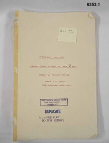 Bendigo Military Museum
Administrative record - "Project Cutlass" - Project Report Mapping Control Survey of New Ireland (PNG), Major SW Snow RASvy Corps, 1957
Item .1 "Project Cutlass" - Project Report Mapping Control Survey of New Ireland (PNG) is a report by the Project Officer Major SW Snow RASvy Corps. The Project commenced in August 1956 and concluded 29 Nov 1957. Traversing and Base line measurement used vehicles and two ships and included nearby islands. Includes two photographs. Item .2 Photograph of Bob Skitch Project Cutlass 1956/57 with theodolite Item .3 Photograph of Chas Beach project Cutlass 1957 Patlangat West Base (cemetery). 6353.1 Manilla Folder containing 49 foolscap sized loose page paper report. 12 pages of Intital report followed by 37 pages of Annexes and Appendices. Last page is map of Project Area. 6353.2 B/W Photograph Bob Skitch with Wild T2 Theodolite Project Cutlas 1956/1957 6353.3 B/W Photograph Chas Beach PATLANGAT WEST BASE (Cemetary) Project Cutlass 1957"Aug 56" on front coverroyal australian survey corps, rasvy, fortuna, army survey regiment, army svy regt, asr -
 Warrnambool and District Historical Society Inc.
Administrative record - Chemist Prescription Book, 1905 to 1910
This ledger contains a chemist's handwritten prescriptions from 1905 to 1910, giving the date, the name of the client and the prescription contents and measurements. The chemist is unnamed but the clients have Warrnambool names and a loose envelope in the ledger addressed to 'Mr H.F. Sambell' suggests that the chemist business may be that of Sambell and Son in Fairy Street Warrnambool. John Sambell established this business in Fairy Street about 1890. He died in 1906 but his son Herbert had joined the business and it was known as Sambell and Son for many years and later as Sambell, Son ad Granddaughter.This prescription book is of interest as a record of a chemist's prescriptions in the early 20th century and it has considerable research value.This is a ledger of 496 pages . It has a cream-coloured hard board cover with remnants of leather binding on the spine. It has ruled pages, an alphabetical index at the front and handwritten entries in ink. The cover is ragged at the edges and stained but the pages are in good condition.Prescription Bookwarrnambool chemists -
 Orbost & District Historical Society
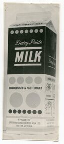
Photograph - photo of a milk carton
Orbost had its own milk distribution and butter factory from 1893 to 1969 when Gippsland Consolidated Milk Products took it over and became the new company. This company also included milk supplies from the Bairnsdale to Maffra region in Gippsland. Four years later, in 1973, this company changed to Gippsland Amalgamated Milk Products which included suppliers from Yarram, Foster, Traralgon and Heyfield. It is likely that this carton photo is from 1969-1973. Also, the quart fluid measurement gave way to Metric from 1971 onwards. Related to Orbost Butter Factory and its demise in the late 1960s.b/w photograph of a milk carton - 1 quart - Dairy Pride Milk1Quart net. Dairy Pride MILK. Homogenised & Pasteurised. A product of Gippsland Consolidated Milk Ltd. Maffra. Victoria.orbost, orbost butter factory, dairying history -
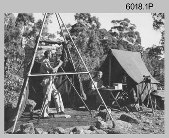 Bendigo Military Museum
Photograph - Royal Australian Survey Corps Surveyors in the Field, Army Survey Regiment, 1950s to 1970s
These three photographs were most likely taken from the 1950s to the 1970s. The RASvy surveyor in each photograph was taking angular measurements with the observer recording their readings on a booking form. They were probably employed in establishing mapping and geodetic control operations or the surveyors may have been in training. Photo .1P was possibly taken at Mount Alexander in Central Victoria, a location close to Bendigo, as the stone cairn in the background of the photo appears to be identical to the cairn presently located on top of the mountain. Personnel and location have been confirmed on another photo in the collection with annotation. These three photographs are of surveyors in the field undertaking observations using theodolites. The photographs were printed on photographic paper and are part of the Army Survey Regiment’s Collection. The photographs were scanned at 300 dpi. .1) - Photo, black & white, c1950s. Unidentified personnel undertaking observations with a Tavistock geodetic theodolite. .2) – Photo, colour, mounted on card, c1960s. Unidentified personnel undertaking observations with a Kern DKM2 theodolite. .3) - Photo, colour, c1970s. Unidentified personnel undertaking observations with a theodolite..1 – not annotated .2 –annotated on front “Kern DKM2, TOPO 10” royal australian survey corps, rasvy, army survey regiment, army svy regt, fortuna, asr, surveying -
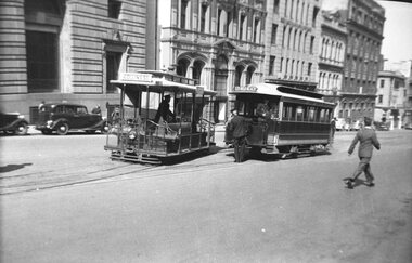 Melbourne Tram Museum
Negative - Cable tram shunting at Market St, Wal Larsen, March 1937
Photograph of shunting a South Melbourne Beach tram at terminus in Market St City. The grip car has the destination of Collins St, while the tailer, South Melbourne Beach. Note the conductor on board the trailer and a 3rd man by the trailer, possibly the shunter. Tne Port and South Melbourne lines closed on 13/3/1937. Photo possibly the same date as item 5061, 6/3/1937.Yields information about shunting cable tram sets at Market St Melbourne.Negative of cable tram set and print with notes on the rear. Black and white print also held.Written on rear of album print "Shunting South Melbourne Beach tram at terminus in Market St City." Written on the rear of the second print - "Shunting at the Market St terminus May 1937, tram No. 34, Transportation 5/11/251, Photo by Wal Larsen". Has printing crop marks and measurements.trams, tramways, cable trams, market st, shunting, collins st