Showing 1285 items matching "municipality"
-
 Bayside Gallery - Bayside City Council Art & Heritage Collection
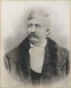
Photograph - gelatin silver photograph, Councillor John Burder Backhouse, Mayor of Brighton 1898, c. 1898
... ...municipality...After an appointment as the sole resident medical officer at the Alfred Hospital, he set up a private medical practice in Brighton in 1887. portrait Councillor Mayor Brighton municipality Town of Brighton Doctor North Ward Cr Backhouse John Burder Backhouose gelatin silver photograph Councillor John Burder Backhouse, Mayor of Brighton 1898 Photograph gelatin silver photograph ...John Burder Backhouse (1855-1935) was elected as a representative of the North Ward for the Town of Brighton in 1893, becoming Mayor in 1898. After an appointment as the sole resident medical officer at the Alfred Hospital, he set up a private medical practice in Brighton in 1887.portrait, councillor, mayor, brighton, municipality, town of brighton, doctor, north ward, cr backhouse, john burder backhouose -
 Bayside Gallery - Bayside City Council Art & Heritage Collection
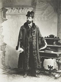
Photograph - gelatin silver photograph, Councillor John Ferrier-Hamilton, Mayor of Brighton, c. 1886
... ...Municipality...He unsuccessfully stood for the Brighton seat in the state elections in 1908 and 1909. portrait Councillor Mayor Brighton Metropolitan Board of Works Municipality Cr. J. Ferrier-Hamilton John Ferrier Hamilton North Ward Mayoral robes gelatin silver photograph Councillor John Ferrier-Hamilton, Mayor of Brighton Photograph gelatin silver photograph ...Cr. John Ferrier-Hamilton (1852-1911) was elected Councillor for the North Ward in Brighton in 1882, becoming Mayor in 1886. Due to ill health he retired from council in 1900 but re-entered council in 1904, becoming Mayor again in 1906. He was commissioner of the Metropolitan Board of Works for five years. He unsuccessfully stood for the Brighton seat in the state elections in 1908 and 1909.portrait, councillor, mayor, brighton, metropolitan board of works, municipality, cr. j. ferrier-hamilton, john ferrier hamilton, north ward, mayoral robes -
 Ararat & District Historical Society (operating the Langi Morgala Museum)
Document - Municipal record
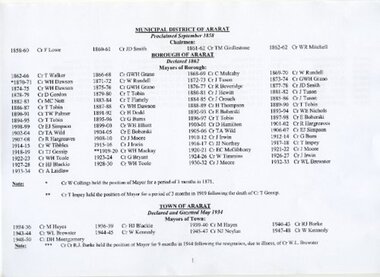
... This document offers an insight into the formative structure of the (now) City of Ararat municipality governing body. As a full listing of 74 past Chairmen and Mayors, from proclamation in 1858 through to 1950, this record provides a glimpse of the social and historic make-up of the town. ...Ararat & District Historical Society (operating the Langi Morgala Museum) 48 Queen Street Ararat grampians This document offers an insight into the formative structure of the (now) City of Ararat municipality governing body. As a full listing of 74 past Chairmen and Mayors, from proclamation in 1858 through to 1950, this record provides a glimpse of the social and historic make-up of the town. ...This document offers an insight into the formative structure of the (now) City of Ararat municipality governing body. As a full listing of 74 past Chairmen and Mayors, from proclamation in 1858 through to 1950, this record provides a glimpse of the social and historic make-up of the town. Single page (double-sided) paper record, listing official members of the Municipal District of Ararat since 1858 including Chairman and Mayors in both the Borough of Ararat and the Town of Ararat up to and including 1990.municipal, borough, town, ararat, chairman, councilors, mayor, 1858, government, local government -
 Greensborough Historical Society
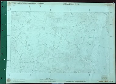
Map, Melbourne and Metropolitan Board of Works. Survey Division, MMBW, Yarra 2500 / 15.26. Yarrambat, Hacketts Road, 1978_07
... Yarrambat, Hacketts Road. Municipality of Diamond Valley 257. Prominent streets include: Black Gully Road, Hacketts Road and Collins Lane. ...Yarrambat, Hacketts Road. Municipality of Diamond Valley 257. Prominent streets include: Black Gully Road, Hacketts Road and Collins Lane. ...Melbourne and Metropolitan Board of Works. Yarra 2500 [base map] 15.26. Yarrambat, Hacketts Road. Municipality of Diamond Valley 257. Prominent streets include: Black Gully Road, Hacketts Road and Collins Lane. Features include Scrubby Creek.MMBW Map in 1:2500 [scale] series. Cream parchment with green tape reinforcing on edges and punched holes on left edge.mmbw, melbourne and metropolitan board of works, shire of diamond valley, yarrambat - maps -
 Whitehorse Historical Society Inc.
Article, Railyards, 27/04/1988 12:00:00 AM
... Nunawading Council spent $62,000 in the campaign against Metrail's now abandoned plan for railyards in the municipality. Ron O'Neill, the strategic planner revealed details of costs in a report to council committee. ...Railways O'Neill Ron City of Nunawading Nunawading Railway Depot Nunawading Council spent $62,000 in the campaign against Metrail's now abandoned plan for railyards in the municipality. Nunawading Council spent $62,000 in the campaign against Metrail's now abandoned plan for railyards in the municipality. ...Nunawading Council spent $62,000 in the campaign against Metrail's now abandoned plan for railyards in the municipality.Nunawading Council spent $62,000 in the campaign against Metrail's now abandoned plan for railyards in the municipality. Ron O'Neill, the strategic planner revealed details of costs in a report to council committee. Payments went to consultants, solicitors. If the railyard had been built there would have been a loss of $77,000 in lost rates alone. The social and economic impact would have been significant. Council had been instrumental in ensuring that an environmental effects statement was prepared.Nunawading Council spent $62,000 in the campaign against Metrail's now abandoned plan for railyards in the municipality. railways, o'neill, ron, city of nunawading, nunawading railway depot -
 Kew Historical Society Inc
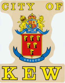
Sign, City of Kew Crest
... Four colour version of the City of Kew Crest, adopted by the Municipality in 1861 for use in its circular seal but later adapted as in this version for printing or for identification. ...Later versions such as this modernise the style for a range of purposes. city of kew crests municipal crests CITY OF KEW / DIEU ET MON DROIT Four colour version of the City of Kew Crest, adopted by the Municipality in 1861 for use in its circular seal but later adapted as in this version for printing or for identification. ...The seal of the former City of Kew is held in the collection of the City of Boroondara, as is the Mayoral Chain of Office. The original design was circular and cast in high relief to allow impressions to be made. Later versions such as this modernise the style for a range of purposes.Four colour version of the City of Kew Crest, adopted by the Municipality in 1861 for use in its circular seal but later adapted as in this version for printing or for identification. There are two examples this version: both transfers designed to be affixed to Council vehicles. The collection includes 11 copies of the large transfers and one copy of the smaller version. The bright colours used were typical of the period. The large version is 375 x 295 mm; the smaller is 205 x 155 mm.CITY OF KEW / DIEU ET MON DROITcity of kew, crests, municipal crests -
 Federation University Historical Collection
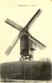
Postcard - Postcard - black and white, Le Moulin, Messines, c1914
... Mesen (Messines in French, historically used in English) is a city located in the Belgian province of West Flanders. The municipality comprises of one main settlement, the town of Mesen proper. ...Barker Library (top floor) Mount Helen goldfields Mesen (Messines in French, historically used in English) is a city located in the Belgian province of West Flanders. The municipality comprises of one main settlement, the town of Mesen proper. ...Mesen (Messines in French, historically used in English) is a city located in the Belgian province of West Flanders. The municipality comprises of one main settlement, the town of Mesen proper. (Wikipedia) Two large battles were fought at Messines during World War One. Black and white postcard of a windmill at Messines, Belgium. chatham-holmes family collection, windmill, messines, moulin, world war, world war 1, world war one, belgium -
 Linton and District Historical Society Inc
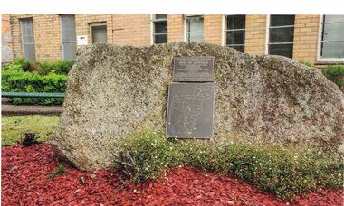
Photograph, Grenville Shire Memorial, Sussex Street, Linton
... The memorial is dedicated "to the Councillors, staff and residents who provided service, loyalty and support to the municipality over 130 years". The photograph was taken in 2014 by Gary Hunt....The memorial is dedicated "to the Councillors, staff and residents who provided service, loyalty and support to the municipality over 130 years". The photograph was taken in 2014 by Gary Hunt. ...Following municipal amalgamations in 1994, the Shire of Grenville ceased to exist, and was incorporated into the Golden Plains Shire. The memorial is dedicated "to the Councillors, staff and residents who provided service, loyalty and support to the municipality over 130 years". The photograph was taken in 2014 by Gary Hunt.Colour photograph showing memorial stone and plaque. The plaque has a map showing localities and boundaries of the former Shire of Grenville. It was erected outside the Golden Plains Shire Offices in Linton to commemorate the history and achievements of the former Shire.grenville shire memorial, shire of grenville, golden plains shire -
 Ringwood and District Historical Society
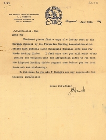
Letter, Ringwood Bowls Club- Letter to J.K. McCaskill, Ringwood Councillor, dated 18th July, 1944, with attached letter from Victorian Bowling Association to Ringwood Borough Council
... The attached letter from the Victorian Bowling Association to the Borough Council suggests that provision be made in recreation areas for sites for bowling greens in municipalities throughout Victoria....The attached letter from the Victorian Bowling Association to the Borough Council suggests that provision be made in recreation areas for sites for bowling greens in municipalities throughout Victoria. Copy of typed letters. ...Copy of typed letters. Letter to Council signed by Hon. General & Bowling Secretary A.J. Roberts, correcting some misinformation given to Council from Ringwood Bowling Club regarding the availability of a site for the proposed Club. The attached letter from the Victorian Bowling Association to the Borough Council suggests that provision be made in recreation areas for sites for bowling greens in municipalities throughout Victoria. -
 Greensborough Historical Society
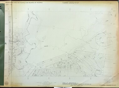
Map, Melbourne and Metropolitan Board of Works. Survey Division, MMBW, Yarra 2500 / 17.27. Central Hurstbridge, 1978_02
... Parish of Greensborough 2724, Municipalities of Diamond Valley 257, Eltham 238 and Whittlesea 239. ...Parish of Greensborough 2724, Municipalities of Diamond Valley 257, Eltham 238 and Whittlesea 239. ...Melbourne and Metropolitan Board of Works. Yarra 2500 [base map] 17-27. Central Hurstbridge. Parish of Greensborough 2724, Municipalities of Diamond Valley 257, Eltham 238 and Whittlesea 239. Prominent streets include: Anzac Avenue and Hurstbridge-Arthurs Creek Road. MMBW Map in 1:2500 [scale] series. Cream parchment with green tape reinforcing on edges and punched holes on left edge.mmbw, melbourne and metropolitan board of works, shire of diamond valley, hurstbridge - maps -
 Greensborough Historical Society
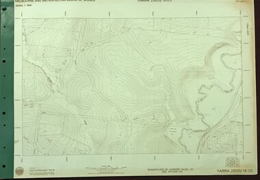
Map, Melbourne and Metropolitan Board of Works. Survey Division, MMBW, Yarra 2500 / 16.25. Wattle Glen, 1978_07
... Wattle Glen. Municipalities of Diamond Valley 257 and Eltham 238. ...Wattle Glen. Municipalities of Diamond Valley 257 and Eltham 238. ...Melbourne and Metropolitan Board of Works. Yarra 2500 [base map] 16-25. Wattle Glen. Municipalities of Diamond Valley 257 and Eltham 238. Prominent streets include: Nimmo Road, Broad Gully Road and Heidelberg-Kinglake Road. Includes Yulong Park.MMBW Map in 1:2500 [scale] series. Cream parchment with green tape reinforcing on edges and punched holes on left edge.mmbw, melbourne and metropolitan board of works, shire of diamond valley, wattle glen - maps -
 Greensborough Historical Society
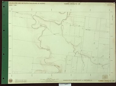
Map, Melbourne and Metropolitan Board of Works. Survey Division, MMBW, Yarra 2500 / 13.26. Yarrambat, Worns Lane, 1978_02
... Yarrambat, Worns Lane. Municipalities of Diamond Valley 257 and Whittlesea 239. ...Yarrambat, Worns Lane. Municipalities of Diamond Valley 257 and Whittlesea 239. ...Melbourne and Metropolitan Board of Works. Yarra 2500 [base map] 13.26. Yarrambat, Worns Lane. Municipalities of Diamond Valley 257 and Whittlesea 239. Prominent streets include: Worns Road, North Oatlands Road and Licola Street. Features include Plenty River.MMBW Map in 1:2500 [scale] series. Cream parchment with green tape reinforcing on edges and punched holes on left edge.mmbw, melbourne and metropolitan board of works, shire of diamond valley, whttlesea, yarrambat - maps -
 Greensborough Historical Society
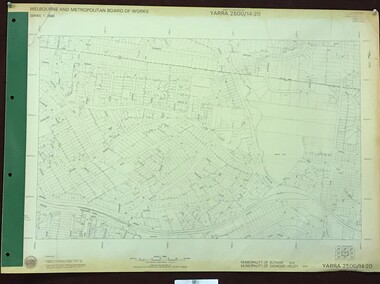
Map, Melbourne and Metropolitan Board of Works. Survey Division, MMBW, Yarra 2500 / 14.20. Montmorency, Sherbourne Road, 1977_06
... Montmorency, Sherbourne Road. Municipality of Diamond Valley 257 and Eltham 238. ...Montmorency, Sherbourne Road. Municipality of Diamond Valley 257 and Eltham 238. ...Melbourne and Metropolitan Board of Works. Yarra 2500 [base map] 14.20. Montmorency, Sherbourne Road. Municipality of Diamond Valley 257 and Eltham 238. Prominent streets: Sherbourne Road, Karingal Drive and Calrossie Avenue. Features include Montmorency Station and Meruka Park.MMBW Map in 1:2500 [scale] series. Cream parchment with green tape reinforcing on edges and punched holes on left edge.mmbw, melbourne and metropolitan board of works, shire of diamond valley, montmorency - maps -
 City of Moorabbin Historical Society (Operating the Box Cottage Museum)
Flyer - Moorabbin Electric Station Estate, Moorabbin, 1941
... The train line from the city to Frankston was electrified in 1922 which intensified the sale in the municipality of Moorabbin, particularly land which was in the vicinity of the railway stations. ...City of Moorabbin Historical Society (Operating the Box Cottage Museum) Joyce Park Jasper Road Ormond melbourne The train line from the city to Frankston was electrified in 1922 which intensified the sale in the municipality of Moorabbin, particularly land which was in the vicinity of the railway stations. ...The train line from the city to Frankston was electrified in 1922 which intensified the sale in the municipality of Moorabbin, particularly land which was in the vicinity of the railway stations. Moorabbin Electric Station Estate Sale of unsold and repossessed Allotments, the original sale was on Saturday 30 May 1925.Example of the progress of the Municipality of MoorabbinAdvertising flyer for auction of real estate sales - plan of building blocks for saleMoorabbin Electric Station Estate, Moorabbin. Auction Saturday 8 March 1941 - 9 villa units 4 shop sitessouth road, station street, taylor street, healey street, jasper street (now redholme street), central avenue, moorabbin, real estate -
 Federation University Historical Collection
Postcard - black and white, Charleroi. Entree de la Ville, c1915
... Charleroi is a city and a municipality of Wallonia, located in the province of Hainaut, Belgium. ...Barker Library (top floor) Mount Helen goldfields Charleroi is a city and a municipality of Wallonia, located in the province of Hainaut, Belgium. ...Charleroi is a city and a municipality of Wallonia, located in the province of Hainaut, Belgium. Heavy fighting took place during World War I due to the city's strategic location on the Sambre. This postcard was most probably purchased during an australian soldier during World War One.Black and white postcard depicting a cobbled street with horse drawn carriage and people gathered around a flag. charleroi, belgium, world war i, world war, henry smerdon holmes -
 Kew Historical Society Inc
Photograph, Centenary Dinner Dance, Kew Civic Hall, 1960
... Original black and white photograph of the seated invited guests at the dinner celebrating the 100th anniversary of the declaration of Kew as an independent municipality. The point of view is from the south end of the building, looking towards the stage at the north end of the main hall. ...The photograph formed part of the collection of WHS Dickinson and was presented to the Kew Historical Society by his daughter in 2018. cr whs dickinson - mayor of kew 1946-1947 civic events - kew (vic) centenary of kew (vic) - 1860-1960 Original black and white photograph of the seated invited guests at the dinner celebrating the 100th anniversary of the declaration of Kew as an independent municipality. The point of view is from the south end of the building, looking towards the stage at the north end of the main hall. ...Original photograph of the Kew Centenary Ball in the new Kew Civic Hall in 1960. The photograph formed part of the collection of WHS Dickinson and was presented to the Kew Historical Society by his daughter in 2018. Original black and white photograph of the seated invited guests at the dinner celebrating the 100th anniversary of the declaration of Kew as an independent municipality. The point of view is from the south end of the building, looking towards the stage at the north end of the main hall. [Originally both halls could be separated or joined by concertina doors.] On the stage, centre, is from left Mr. W. Birrell [Town Clerk], Cr WHS Dickinson [the Mayor], and The Rt Hon Robert Menzies, MP for Kew and Prime Minister of Australia.cr whs dickinson - mayor of kew 1946-1947, civic events - kew (vic), centenary of kew (vic) - 1860-1960 -
 Kew Historical Society Inc
Badge - Fundraising Button, Women’s Hospital Appeal 1923, 1923
... In February when the buttons were sold, The Argus reported that: ‘Each suburban municipality has formed a committee under its mayoress, to assist in the button distribution, and local committees in the country are also working for the success of the appeal. ...In February when the buttons were sold, The Argus reported that: ‘Each suburban municipality has formed a committee under its mayoress, to assist in the button distribution, and local committees in the country are also working for the success of the appeal. ...Frances Rigg was a local business identity in Kew, at one stage managing the local branch of the English, Scottish and Australian (ES&A) Bank at 175 High Street from c. 1920 until the 1940s. After Francis Rigg’s death, the collection of buttons and medallions was inherited by his son, Ken Rigg (1922-2014). The collection was subsequently donated to the Kew Historical Society in 2015 by Francis' grandson, Adrian Rigg, at the time of the Gallipoli & Beyond Commemoration in 2015. The collection covers a period of almost 40 years. The majority of the buttons are patriotic buttons, issued and sold during and immediately after the First World World War (1914-1918) to raise funds for national and overseas causes. The collection also includes a number of locally significant sporting event buttons and sporting club medallions, issued in the 1920s and 1930s.Patriotic and other pressed tin buttons and badges were produced in large numbers in the first decades of the twentieth century. By nature, insubstantial and ephemeral, they have not always survived. The collections of badges, buttons and medallions in the Kew Historical Society collection is homogenous and yet diverse, ranging from buttons sold to raise funds for the war efforts in 1914-18 and 1939-45, to those used at festivals and sporting events. Because of the manufacturing process, many surviving buttons and badges have been affected by inadequate storage, suffering from oxidisation and physical damage. These survivors are now historically and socially significant artefacts, revealing much about the attitudes and values of the period in which they were produced. Their widespread distribution means that they are frequently significant at a local, state, national and international level.A postwar fundraising button featuring a simple design using white text in a red boarder with and central blue cross. In February when the buttons were sold, The Argus reported that: ‘Each suburban municipality has formed a committee under its mayoress, to assist in the button distribution, and local committees in the country are also working for the success of the appeal. Kiosks are prohibited in the city streets, but many suburban councils have granted permission for their erection. In addition to buttons, many kinds of saleable articles will be obtainable at the kiosks.’"Women’s Hospital Appeal 1923"royal womens hospital, fundraising buttons, badges -
 Kew Historical Society Inc
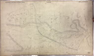
Map, MMBW, MMBW Plan No.64 Kew & Heidelberg, 1900-1910
... The map shows the extent of urban development by that time, prominent institutions and the outlines of built structures in the municipality. Contour lines and historic flood levels were added in ink to the map at a later stage....The map shows the extent of urban development by that time, prominent institutions and the outlines of built structures in the municipality. Contour lines and historic flood levels were added in ink to the map at a later stage. ...The Melbourne and Metropolitan Board of Works (MMBW) was established by an act of the Victorian Parliament in 1890 to prepare for and to implement a sewerage and water reticulation system across what was then inner Melbourne, its surrounding and middle distance suburbs, including Kew. The MMBW was disbanded in 1991.The map collection of the Kew Historical Society has at its core the historic maps assembled and originally stored in the City Engineer's Department of the City of Kew. These include maps in a number of scales. The vast majority of maps were produced by the MMBW in the first two decades of the twentieth century, and are solid working maps, backed by linen for durability. These maps are historically significant to Kew, the City of Boroondara and to the history of the development of state utilities in Victoria. A number of the Kew maps have additional details added by former municipal officers, including the levels reached by various floods. As these were working documents, information was added to them long after the period of their initial production and distribution.Early map of part of the Borough of Kew, created in the first decade of the twentieth century, at a scale 160 ft to 1 inch. The map covers what was then the northern most part of Kew, bordered on its north and west by the Yarra River, in the East by Connor's Creek and by the Asylum in the south. The map shows the extent of urban development by that time, prominent institutions and the outlines of built structures in the municipality. Contour lines and historic flood levels were added in ink to the map at a later stage.MELBOURNE AND METROPOLITAN BOARD OF WORKS / PLAN NO. 64 / KEW & HEIDELBERGmelbourne & metropolitan board of works, mmbw maps, mmbw plans, borough of kew, cartography -
 Kew Historical Society Inc
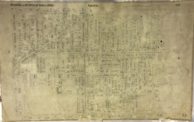
Map, MMBW, MMBW Plan No.65 Kew & Heidelberg, 1900-1910
... The map shows the extent of urban development by that time, prominent institutions and the outlines of built structures in the municipality. Contour lines were added in ink to the map at a later stage....The map shows the extent of urban development by that time, prominent institutions and the outlines of built structures in the municipality. Contour lines were added in ink to the map at a later stage. ...The Melbourne and Metropolitan Board of Works (MMBW) was established by an act of the Victorian Parliament in 1890 to prepare for and to implement a sewerage and water reticulation system across what was then inner Melbourne, its surrounding and middle distance suburbs, including Kew. The MMBW was disbanded in 1991.The map collection of the Kew Historical Society has at its core the historic maps assembled and originally stored in the City Engineer's Department of the City of Kew. These include maps in a number of scales. The vast majority of maps were produced by the MMBW in the first two decades of the twentieth century, and are solid working maps, backed by linen for durability. These maps are historically significant to Kew, the City of Boroondara and to the history of the development of state utilities in Victoria. A number of the Kew maps have additional details added by former municipal officers, including the levels reached by various floods. As these were working documents, information was added to them long after the period of their initial production and distribution.Early map of part of the Borough of Kew, created in the first decade of the twentieth century, at a scale 160 ft to 1 inch. The map covers what was then the south central part of Kew, bordered on its north by Malmsbury Street, in the west by Florence Avenue, in the south by Barkers Road, and in the east by Princess Street. The map shows the extent of urban development by that time, prominent institutions and the outlines of built structures in the municipality. Contour lines were added in ink to the map at a later stage.MELBOURNE AND METROPOLITAN BOARD OF WORKS / PLAN NO. 65 / KEW & HEIDELBERGmelbourne & metropolitan board of works, mmbw maps, mmbw plans, borough of kew, cartography -
 Kew Historical Society Inc
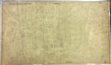
Map, MMBW, MMBW Plan No.66 Kew, 1900-1910
... The map shows the extent of urban development by that time, prominent institutions and the outlines of built structures in the municipality. Contour lines were added in ink to the map at a later stage....The map shows the extent of urban development by that time, prominent institutions and the outlines of built structures in the municipality. Contour lines were added in ink to the map at a later stage. ...The Melbourne and Metropolitan Board of Works (MMBW) was established by an act of the Victorian Parliament in 1890 to prepare for and to implement a sewerage and water reticulation system across what was then inner Melbourne, its surrounding and middle distance suburbs, including Kew. The MMBW was disbanded in 1991.The map collection of the Kew Historical Society has at its core the historic maps assembled and originally stored in the City Engineer's Department of the City of Kew. These include maps in a number of scales. The vast majority of maps were produced by the MMBW in the first two decades of the twentieth century, and are solid working maps, backed by linen for durability. These maps are historically significant to Kew, the City of Boroondara and to the history of the development of state utilities in Victoria. A number of the Kew maps have additional details added by former municipal officers, including the levels reached by various floods. As these were working documents, information was added to them long after the period of their initial production and distribution.Early map of part of the Borough of Kew, created in the first decade of the twentieth century, at a scale 160 ft to 1 inch. The map covers what was then the south eastern part of Kew, bordered on its north by Adeney Avenue, in the west by Sackville Street, in the south by Barkers Road, and in the east by Burke Road. The map shows the extent of urban development by that time, prominent institutions and the outlines of built structures in the municipality. Contour lines were added in ink to the map at a later stage.MELBOURNE AND METROPOLITAN BOARD OF WORKS / PLAN NO. 66 / KEW melbourne & metropolitan board of works, mmbw maps, mmbw plans, borough of kew, cartography -
 Melbourne Tram Museum
Document - Report, Melbourne & Metropolitan Tramways Board (MMTB), "Municipal Miles, late 1920's to mid 1930's
... File- card, green grey - Rondo of London type, titled "Municipal Miles" - giving the calculations and background paperwork for the breakdown of the tramway system by municipality. Used late 1920's to mid 1930's. ...Melbourne Tram Museum 8 Wallen Road Hawthorn melbourne Trams tramways MMTB Trackwork Mileages Reports Councils File- card, green grey - Rondo of London type, titled "Municipal Miles" - giving the calculations and background paperwork for the breakdown of the tramway system by municipality. Used late 1920's to mid 1930's. The top sheet, scanned, though superseded shows the route miles by double track, single track, shared at council boundaries and the total miles of track. ...File- card, green grey - Rondo of London type, titled "Municipal Miles" - giving the calculations and background paperwork for the breakdown of the tramway system by municipality. Used late 1920's to mid 1930's. The top sheet, scanned, though superseded shows the route miles by double track, single track, shared at council boundaries and the total miles of track. See Reg Item 2083 for tram miles for the system as a whole - was this information required for rate valuation returns.trams, tramways, mmtb, trackwork, mileages, reports, councils -
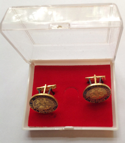 Warrnambool and District Historical Society Inc.
Accessory - Cuff Links, Late 20th century
... Warrnambool, first settled in 1847, was proclaimed a Municipality in 1856, a Borough in 1863, a Town in 1883 and a City in 1918. ...Warrnambool, first settled in 1847, was proclaimed a Municipality in 1856, a Borough in 1863, a Town in 1883 and a City in 1918. ...These cuff links were produced for the Warrnambool City Council presumably to give as gifts to visiting dignitaries etc. They may also have been available for the public to purchase. Warrnambool, first settled in 1847, was proclaimed a Municipality in 1856, a Borough in 1863, a Town in 1883 and a City in 1918. These cuff links are of minor interest as an example of an item produced for the Warrnambool City Council – to use either as gifts or to sell to the public as a memento of the city. These are round metal cufflinks (2) outlined in gold with gold pins (two prongs and a bar) for attachment to the shirt sleeves. The cuff links have the City of Warrnambool logo with gold, blue and cream printing and enamelling. The cuff links are in a plastic box which has a white base and a clear plastic lid and red velvet lining. The cuff links are attached to the inside of the box with black plastic strips. ‘City of Warrnambool, Victoria, By These We Flourish’warrnambool city council, cuff links -
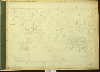 Greensborough Historical Society
Map, Melbourne and Metropolitan Board of Works. Survey Division, MMBW, Yarra 2500 / 15.23. Diamond Creek Reserve, 1978_02
... Yarra 2500 [base map] 15.23. Hurstbridge. Municipality of Diamond Valley 257. Prominent streets include: Challenger Street, James Cook Drive and Ryans Road / Main Street. ...Yarra 2500 [base map] 15.23. Hurstbridge. Municipality of Diamond Valley 257. Prominent streets include: Challenger Street, James Cook Drive and Ryans Road / Main Street. ...Melbourne and Metropolitan Board of Works. Yarra 2500 [base map] 15.23. Hurstbridge. Municipality of Diamond Valley 257. Prominent streets include: Challenger Street, James Cook Drive and Ryans Road / Main Street. Features include the Diamond Creek and Diamond Creek Reserve.MMBW Map in 1:2500 [scale] series. Cream parchment with green tape reinforcing on edges and punched holes on left edge.mmbw, melbourne and metropolitan board of works, shire of diamond valley, diamond creek - maps -
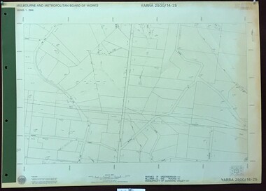 Greensborough Historical Society
Map, Melbourne and Metropolitan Board of Works. Survey Division, MMBW, Yarra 2500 / 14.25. Plenty, Heard Road, 1978_02
... Parishes of Greensborough 2724, Nillumbik 3310 and Morang 3183. Municipality of Diamond Valley 257. Prominent streets include: Heard Road, Seymour Drive and Yan Yean Road....Parishes of Greensborough 2724, Nillumbik 3310 and Morang 3183. Municipality of Diamond Valley 257. Prominent streets include: Heard Road, Seymour Drive and Yan Yean Road. mmbw melbourne and metropolitan board of works shire of diamond valley plenty - maps MMBW Map in 1:2500 [scale] series. ...Melbourne and Metropolitan Board of Works. Yarra 2500 [base map] 14.25. Plenty, Heard Road. Parishes of Greensborough 2724, Nillumbik 3310 and Morang 3183. Municipality of Diamond Valley 257. Prominent streets include: Heard Road, Seymour Drive and Yan Yean Road.MMBW Map in 1:2500 [scale] series. Cream parchment with green tape reinforcing on edges and punched holes on left edge.mmbw, melbourne and metropolitan board of works, shire of diamond valley, plenty - maps -
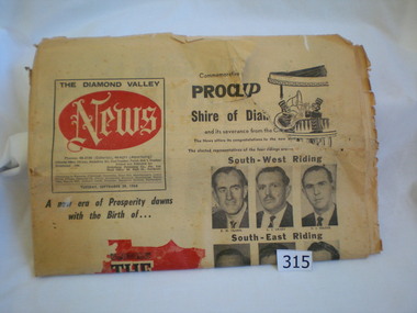 Greensborough Historical Society
Newspaper, Diamond Valley News, Diamond Valley News. 29 Sept. 1964 : Commemorative edition : Proclamation of the Shire of Diamond Valley, 29/09/1964
... In 1960 following inequitable rate increases, it was proposed that the 'north ward' sever itself from Heidelberg and form its own municipality. The Shire was abolished in 1994 and areas redistributed to Banyule, Nillumbik and Darebin councils....In 1960 following inequitable rate increases, it was proposed that the 'north ward' sever itself from Heidelberg and form its own municipality. The Shire was abolished in 1994 and areas redistributed to Banyule, Nillumbik and Darebin councils. ...The Shire of Diamond Valley was formerly the north ward of the City of Heidelberg. In 1960 following inequitable rate increases, it was proposed that the 'north ward' sever itself from Heidelberg and form its own municipality. The Shire was abolished in 1994 and areas redistributed to Banyule, Nillumbik and Darebin councils.This newspaper reports on the history and politics of the new Shire of Diamond Valley. It includes news articles and advertising material from local businesses. 40 page commemorative edition. Yellowed newsprint. Front cover icludes "The Shire of Diamond Valley" on red outline map of shire and photos of the 12 inaugural councillors. 3 copies.shire of diamond valley, greensborough, diamond valley news -
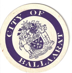 Hymettus Cottage & Garden Ballarat
Work on paper - Coaster, City of Ballaarat drinks coaster
... This circular heavy paper coaster depicting the city's coat of arms was used by the City of Ballaarat in the 1970s and 80s until the city was merged with wider municipalities around Ballarat's urban fringe....This circular heavy paper coaster depicting the city's coat of arms was used by the City of Ballaarat in the 1970s and 80s until the city was merged with wider municipalities around Ballarat's urban fringe. drinks coaster Ballarat armorial City of Ballaarat drinks coaster Work on paper Coaster ...Drinks coasters were introduced to preserve surfaces from the stains from drink glasses. This circular heavy paper coaster depicting the city's coat of arms was used by the City of Ballaarat in the 1970s and 80s until the city was merged with wider municipalities around Ballarat's urban fringe.drinks coaster, ballarat, armorial -
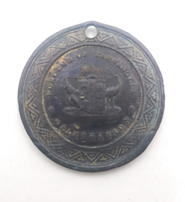 Tarnagulla History Archive
Borough of Tarnagulla, Queen Victoria Golden Jubilee Medal, 1887
... In 1887 the Tarnagulla Borough Council, along with many other municipalities throughout Australia, celebrated Queen Victoria's Jubilee in great style, with a street parade and a feast at the Recreation Reserve. ...In 1887 the Tarnagulla Borough Council, along with many other municipalities throughout Australia, celebrated Queen Victoria's Jubilee in great style, with a street parade and a feast at the Recreation Reserve. ...David Gordon Collection. In 1887 the Tarnagulla Borough Council, along with many other municipalities throughout Australia, celebrated Queen Victoria's Jubilee in great style, with a street parade and a feast at the Recreation Reserve. To mark the occasion, the local schoolchildren were each presented with one of these medallions. -
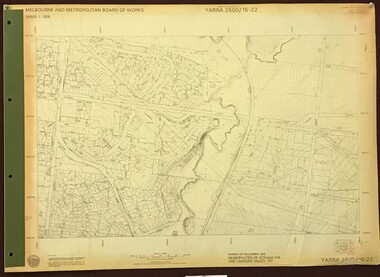 Greensborough Historical Society
Map, Melbourne and Metropolitan Board of Works. Survey Division, MMBW, Yarra 2500 / 15.22. Eltham North. Allendale Road, 1979_08
... Parish of Nillumbik. Municipalities of Eltham 238 and Diamond Valley 257. ...Parish of Nillumbik. Municipalities of Eltham 238 and Diamond Valley 257. ...Melbourne and Metropolitan Board of Works. Yarra 2500 [base map] 15.22. Eltham North, Allendale Road. Parish of Nillumbik. Municipalities of Eltham 238 and Diamond Valley 257. Prominent streets include: Allendale Road, Godber Road and Ryans Road. Features include the Diamond Creek.MMBW Map in 1:2500 [scale] series. Cream parchment with green tape reinforcing on edges and punched holes on left edge.mmbw, melbourne and metropolitan board of works, shire of diamond valley, nillumbik, eltham - maps -
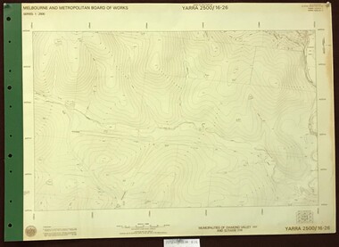 Greensborough Historical Society
Map, Melbourne and Metropolitan Board of Works. Survey Division, MMBW, Yarra 2500 / 16.26. Diamond Creek, Broadgully Road, 1978_07
... Diamond Creek, Broad Gully Road. Municipalities of Diamond Valley 257 and Eltham 238. ...Diamond Creek, Broad Gully Road. Municipalities of Diamond Valley 257 and Eltham 238. ...Melbourne and Metropolitan Board of Works. Yarra 2500 [base map] 16.26. Diamond Creek, Broad Gully Road. Municipalities of Diamond Valley 257 and Eltham 238. Prominent streets include: Wadeson Road, Broad Gully Road and Glenhaven Road. Features include the Diamond Creek.MMBW Map in 1:2500 [scale] series. Cream parchment with green tape reinforcing on edges and punched holes on left edge.mmbw, melbourne and metropolitan board of works, shire of diamond valley, diamond creek - maps -
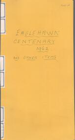 Bendigo Historical Society Inc.
Newspaper - Lydia Chancellor collection: Eaglehawk centenary 1962
... Eaglehawk was declared a municipality 22/7/1862. It was to be made up of a council of seven, constituted as follows:- 1 councillor from Peg Leg Gully, 1 from Sailor's Gully, 1 from Myers Flat, 2 from California Gully and 2 from Eaglehawk proper....History House 11 Mackenzie Street Bendigo goldfields Eaglehawk was declared a municipality 22/7/1862. It was to be made up of a council of seven, constituted as follows:- 1 councillor from Peg Leg Gully, 1 from Sailor's Gully, 1 from Myers Flat, 2 from California Gully and 2 from Eaglehawk proper. ...Eaglehawk was declared a municipality 22/7/1862. It was to be made up of a council of seven, constituted as follows:- 1 councillor from Peg Leg Gully, 1 from Sailor's Gully, 1 from Myers Flat, 2 from California Gully and 2 from Eaglehawk proper.Yellow folder titled Eaglehawk centenary 1962 and other items. Inside several newspaper articles all relating the Eaglehawk centenary in 1962.eaglehawk, centenary, 1962