Showing 14773 items
matching north road
-
 Glen Eira Historical Society
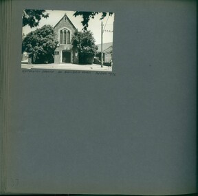
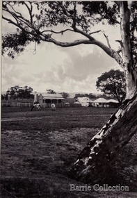
Album - Album page, Methodist Church, Bambra Road, 55, Circa 1972
... 55 Bambra Road, Caulfield North, Melbourne, Victoria... 198 pages. trevor hart caulfield north bambra road methodist ...This photograph is part of the Caulfield Historical Album 1972. This album was created in approximately 1972 as part of a project by the Caulfield Historical Society to assist in identifying buildings worthy of preservation. The album is related to a Survey the Caulfield Historical Society developed in collaboration with the National Trust of Australia (Victoria) and Caulfield City Council to identify historic buildings within the City of Caulfield that warranted the protection of a National Trust Classification. Principal photographer thought to be Trevor Hart, member of Caulfield Historical Society. Most photographs were taken between 1966-1972 with a small number of photographs being older and from unknown sources. All photographs are black and white except where stated, with 386 photographs over 198 pages.Page 37 of Photograph Album with one landscape photograph of the Methodist church.Handwritten: METHODIST CHURCH 55 BAMBRA ROAD 14 DEC 1972 / 37 [bottom left]trevor hart, caulfield north, bambra road, methodist church -
 Glen Eira Historical Society
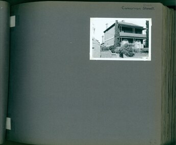
Album - Album page, Carnarvon Road, Circa 1972
... 1 Carnarvon Road, Caulfield North, Melbourne, Victoria... caulfield north carnarvon road houses verandahs balconies gardens ...This photograph is part of the Caulfield Historical Album 1972. This album was created in approximately 1972 as part of a project by the Caulfield Historical Society to assist in identifying buildings worthy of preservation. The album is related to a Survey the Caulfield Historical Society developed in collaboration with the National Trust of Australia (Victoria) and Caulfield City Council to identify historic buildings within the City of Caulfield that warranted the protection of a National Trust Classification. Principal photographer thought to be Trevor Hart, member of Caulfield Historical Society. Most photographs were taken between 1966-1972 with a small number of photographs being older and from unknown sources. All photographs are black and white except where stated, with 386 photographs over 198 pages. This house is part of HO14 Caulfield North and Environs - Heritage Overlay as a contributing property.Page 42 of Photograph Album with one photograph of a double-storey house on Carnarvon Road.Handwritten: Carnarvon Road [top right hand corner] / 42 [bottom right]trevor hart, caulfield north, carnarvon road, houses, verandahs, balconies, gardens -
 Glen Eira Historical Society
Document - Regent Street, 4/1B, Elsternwick
... Caulfield North Balaclava Road Flats Brick Document Regent Street, 4 ...A newspaper real estate ad dated 18/11/2005 on forthcoming sale of luxurious apartment. Gives details of interior fittings.elsternwick, regent street, cohen david, polimene reece, caulfield north, balaclava road, flats, brick -
 Federation University Historical Collection
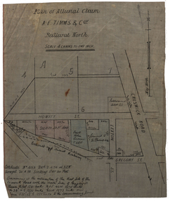
Plan, Plan of Alluvial Claim of A.E. Timms and Co, 1894, 02/04/1894
... & co. howitt st ballarat north creswick road alluvial claim ...This item was removed from Catalogue Number 3601Plan of a lease located near Cresick Road. Scale: 4 chains to 1 inch (1:3168) WGS 84 37 32 35 South 143 50 50 Easttimms, a.e. timms & co., howitt st, ballarat north, creswick road, alluvial claim, mining -
Whitehorse Historical Society Inc.
Article, Lights coming up at last? Kerrimuir's new count, 1967
... North Primary School Springfield Road Blackburn North ...Box Hill Council has been pressured to erect traffic lights on the Springfield Road, Middleborough Road intersection.Box Hill Council has been pressured to erect traffic lights on the Springfield Road, Middleborough Road intersection. The pressure has come from Blackburn North State School Committee and Mrs N.G. Vance.Box Hill Council has been pressured to erect traffic lights on the Springfield Road, Middleborough Road intersection.city of box hill, blackburn north primary school, springfield road, blackburn north, middleborough road, blackburn north, vance, n. g. (mrs) -
Whitehorse Historical Society Inc.
Map, Aspinall's old abattoirs, Box Hill, 1937
... Grove Box Hill North Aspinall Road Box Hill North Abattoirs Hand ...Hand drawn plan of subdivision of old abattoirs site, Woodhouse Grove, Box Hill North.Hand drawn plan of subdivision of old abattoirs site, Woodhouse Grove, Box Hill North.Hand drawn plan of subdivision of old abattoirs site, Woodhouse Grove, Box Hill North.land subdivision, aspinall's estate, woodhouse grove, box hill north, aspinall road, box hill north, abattoirs -
 Whitehorse Historical Society Inc.
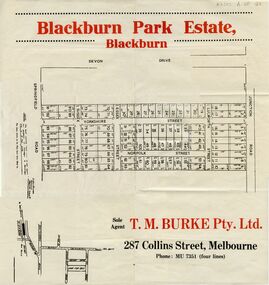
Document, Blackburn Park Estate, n.d
... Whitehorse Historical Society Inc. 2-10 Deep Creek Road ...Land Sale plan for 'Blackburn Park Estate'Land Sale plan for 'Blackburn Park Estate' between Springfield and Junction Roads. Agent T.M. Burke Pty Ltd.Land Sale plan for 'Blackburn Park Estate'blackburn park estate, blackburn north, springfield road, junction road, sussex street, essex street, yorkshire street, lulworth street, norfolk street -
 Whitehorse Historical Society Inc.
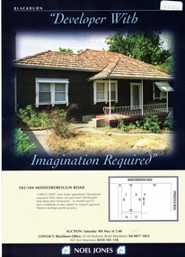
Pamphlet, Middleborough Road, 1/05/1998 12:00:00 AM
... Mitcham melbourne noel jones middleborough road blackburn north ...Leaflet for auction of houseLeaflet for auction of house, 502 - 504 Middleborough Road, 9 / 5 / 1998. Coloured photograph. Development suggested.Leaflet for auction of housenoel jones, middleborough road, blackburn north, springfield road, auctions -
Whitehorse Historical Society Inc.
Letter - Correspondence, Abattoir Property, 1937
... Aspinall Road Box Hill North Koonung Creek Land Subdivision Letters ...Letters between City of Box Hill and Shire of Blackburn and Mitcham re sale of abattoir property with a plan of the subdivision.Letters between City of Box Hill and Shire of Blackburn and Mitcham re sale of abattoir property with a plan of the subdivision.Letters between City of Box Hill and Shire of Blackburn and Mitcham re sale of abattoir property with a plan of the subdivision.city of box hill, shire of blackburn and mitcham, abattoirs paddock, aspinall's estate, woodhouse grove, box hill north, aspinall road, box hill north, koonung creek, land subdivision -
Whitehorse Historical Society Inc.
Letter - Correspondence, Abattoir property, 1937
... Aspinall Road Box Hill North Koonung Creek Land Subdivision Letter ...Letter from City of Box Hill to Shire of Blackburn and Mitcham re the unsuccessful sale of the abattoir property.Letter from City of Box Hill to Shire of Blackburn and Mitcham re the unsuccessful sale of the abattoir property.Letter from City of Box Hill to Shire of Blackburn and Mitcham re the unsuccessful sale of the abattoir property.city of box hill, shire of blackburn and mitcham, abattoirs paddock, aspinalls estate, woodhouse grove, box hill north, aspinall road, box hill north, koonung creek, land subdivision -
 Whitehorse Historical Society Inc.
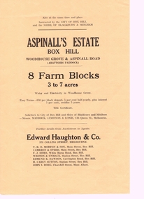
Pamphlet, Aspinall's Estate Box Hill, 1937
... woodhouse grove box hill north aspinall road mont albert box hill ...Pamphlet advertising 8 farm blocks on Aspinall Estate,Pamphlet advertising 8 farm blocks on Aspinall Estate, Box Hill on Woodhouse Grove and Aspinall Road, 27 October 1937. Sale was for the City of Box Hill and the Shire of Blackburn and Mitcham.. A plan is included. A list of other sales is on the verso.Pamphlet advertising 8 farm blocks on Aspinall Estate,auctions, aspinalls estate, abattoirs paddock, woodhouse grove, box hill north, aspinall road, mont albert, box hill, surrey hills, burwood, edward haughton pty ltd, t. r. b. morton & son, cameron and speed, f. j. sides, weston and unmacht, edmund dawson, h. carey sutton (estate agent), j. i. doeg, city of box hill, shire of blackburn and mitcham -
Whitehorse Historical Society Inc.
Article, Old grove bears fruit, 2012
... Surrey Road Blackburn North... Mitcham melbourne Junction Road Blackburn North Surrey Road ...A 1.03 hectare block, formerly an orchard in Blackburn North is now up for sale.A 1.03 hectare block, formerly an orchard in Blackburn North is now up for sale.A 1.03 hectare block, formerly an orchard in Blackburn North is now up for sale.junction road, blackburn north, surrey road blackburn north, cock, herbert -
Whitehorse Historical Society Inc.
Document, Biography of Dr Francis John Drake, 1/11/1983 12:00:00 AM
... Donvale Mitcham North Whitehorse Road Mitcham Elizabeth Street ...A brief biography of Doctor Francis John Drake - medical practitioner and early land owner in the Mitcham area.A brief biography of Doctor Francis John Drake - medical practitioner and early land owner in the Mitcham area. Compiled by Andrew Hillier. Includes copies of Dr Drake's Marriage Certificate, entry in Register of Deaths and a portrait.A brief biography of Doctor Francis John Drake - medical practitioner and early land owner in the Mitcham area. drake, francis john, dr, park road, mitcham, heads road, donvale, mitcham north, whitehorse road, mitcham, elizabeth street, mitcham, station street, mitcham, colombo street, . mitcham, mitcham road, mitcham, doncaster east road, mitcham, mcdowall street, mitcham -
Whitehorse Historical Society Inc.
Document, Toogood's Estate, 15/12/1956 12:00:00 AM
... Auction brochure of Toogood's Estate, Middleborough Road..., Middleborough Road, Box Hill North Auction brochure of Toogood's Estate ...Auction brochure of Toogood's Estate, Middleborough Road, Box Hill NorthAuction brochure of Toogood's Estate, Middleborough Road, Box Hill NorthAuction brochure of Toogood's Estate, Middleborough Road, Box Hill Northtoogood's estate, box hill north, middleborough road, box hill -
 Port Fairy Historical Society Museum and Archives
Photograph, Albert Rd NS Section house removed c1995
... This house in Albert Road Port Fairy North was bought... fairy north albert road coloured photograph Albert Rd NS Section ...This house in Albert Road Port Fairy North was bought and removed by the Victorian Government to make way for a new section of the Princes Highway that was to loop around and bypass the town. It was last owned and farmed by Claude and Katrine Brown. Katrine was the library teacher at the Consolidated School in the 1960's.coloured photographcottage, building, home, house, port fairy north, albert road -
 Whitehorse Historical Society Inc.
Photograph - Black and white photograph, Harwood property
... Harwood property at 17-21 Junction Road North Blackburn.... property at 17-21 Junction Road North Blackburn. Harwood property ...Harwood property at 17-21 Junction Road North Blackburn.harwood, nth blackburn, junction road -
 Bayside Gallery - Bayside City Council Art & Heritage Collection
Map, H.B. Foot, Plan of the Brighton Estate containing 5120 acres, first special survey at Port Phillip, c. 1842
... miles south from Melbourne, bounded by North Road, East Boundary... by North Road, South Road and East Boundary Road. The plan shows... Melbourne, bounded by North Road, East Boundary Road, South Road ...This plan records the Brighton Estate, also known as Dendy's Special Survey. In 1840 Henry Dendy, a farmer in Surrey, England acquired a "Special Survey" from the Commissioners for Land and Emigration which gave him the right to choose land in Port Phillip for the low price of £1 per acre for 5120 acres. Dendy appointed Jonathan Binns Were, as his agent, who later became a partner. Together, Dendy and Were decided on an area 5 miles south from Melbourne, bounded by North Road, East Boundary Road, South Road and to the west by Port Phillip Bay. Their Brighton Estate was first surveyed by T. S. Townsend in May 1841 and was re-surveyed by Robert Hoddle. Dendy and Were were making plans to sell the land and advertised a 30-guinea prize for the best subdivision which was to be divided into a village, marine residences, suburban and cultivation allotments, with the remainder being divided into country sections. The competition was won by H.B. Foot, who planned the village around a reserve and crescents and a 'green belt' forming the town boundary. brighton estate, dendy's special survey, special survey, henry dendy, jonathan binns were, w.b. were, survey, plan, map, brighton, george ward cole, baker's lithographer, hibernian, subdivision, town planning, cartographic material, h.b. foot -
Glen Eira Historical Society
Article - Balaclava Road Primary School No. 3820
... 186 Balaclava Road, North Caulfield, Victoria, Australia... College Douglas Tim Teachers Danby Michael Balaclava Road ...An article dated 29/03/2011 from the Caulfield/ Port Phillip Leader, announcing the opening of Caulfield Junior College’s new learning and library space.caulfield junior college, douglas tim, teachers, danby michael, balaclava road, southwick david, caulfield north, parliamentary representatives, tucker road primary, colleges, glen eira college, primary education -
Glen Eira Historical Society
Letter - Anderson, Irene
... 21 Langdon Road, North Caulfield, Victoria, Australia ...This file contains 3 stapled sleeves packaging to Irene Anderson’s research into the Langdon and Webb families (a photocopy of the Caulfield Historical Society minutes for 21/05/1980, Correspondence undated) with the secretary of the Society re a visit to the Langdon home and an annotated photocopy of an order by the Prahran Mechanics Institure for the Anderson book on the Langdon a note re a residents’ query about 523 Neerim Road.local history, langdon clive (mrs), genealogy, langdon, beaumaris beach road 411., anderson richard, anderson irene, prahran mechanics institute, anderson mary ann, glen eira historical society, neerim road 523, ballantyne, poath road, webb, eddie mary, halstead, 5th caulfield scout group, architectural features -
Glen Eira Historical Society
Letter - MEMORIES GLEN EIRA ROAD
... 10 Helenslea Road, Caulfield North ...2 items: 1/A ten page handwritten letter from Mrs. C.R. Biesse on 12/12/1976 to Mr. Murray. The letter gives her memories of the area around Judge Hood’s Estate, related to her by an elderly acquaintance and her grandfather. Includes a small handdrawn map. 2/Handwritten research by Claire Barton on street names and residents off Orrong Road in 1911 Sands and McDougall directory.biesse c.r. mrs., merton street, caulfiled north, judge hood, hood crescent, droving, judge hood’s estate, land subdivision, judge stephens, st. mary’s church, otira road, helenslea road, shelford, landscapes, kerr b. mrs., palmer florence mrs., morrice street, glen eira road, kambea grove, bushland, cattle, mitchell mr. builder, palmer florence, mitchell colin, mitchell clive, mitchell francis, mitchell mrs., perry family, orrong road, st. aubins ave., ‘orotava’, hayes g.h., ‘kambea’, lothian henry, oswald j.d., ‘merton’, glen eira road -
Tatura Irrigation & Wartime Camps Museum
Book, Specialty Press Ltd, Ministers of Water Supply in Victoria, 1965
... 611 Blackburn road, North Clayton, Victoria, Australia ...Green linen-like hard cover. Gold lettering on front cover. Title and author L.G. Houston water supply -
 Sunshine and District Historical Society Incorporated
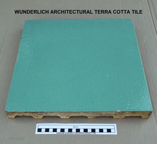
WUNDERLICH TILE, Wunderlich Limited, Circa 1965
... 47 McIntyre Road, North Sunshine, Victoria, Australia ...In the Sunshine Advocate of 21/03/1925 it is reported that Wunderlich Ltd decided to establish works in Sunshine for the manufacture of terra cotta and faience for the facing of city buildings. The product was intended to imitate granite, which would give a brighter appearance to concrete walls. A stone surface finish to the terra cotta could be achieved by applying a variety of colour combinations of glazes with a special 'spackle' gun. A building that is still standing and has the imitation granite finish terra cotta is the Nicholas Building at 21 - 47 Swanston Street, Melbourne. The Nicholas Building was designed by Harry Norris for Alfred Nicholas (Aspro fame), and was built during 1925 - 1926. The building is classified by the National Trust (B4079) and has the Victorian Heritage Register (H2119). During my employment in the factory from 1964 to 1969 the tiles were generally faced with single colour glazes. For some small jobs a light coloured mottled finish was achieved by spattering a white glaze over a cream coloured background or vice versa. There were no imitation granite jobs done, probably because of changing attitudes to the intended appearance of buildings. The green coloured tile in our collection is an unfinished (untrimmed) retain tile typical of the green coloured tiles that were made for the two stages of the Commonwealth Centre Building (colloquially known as the Green Latrine), that was once located on the corner of Spring and Victoria Streets in Melbourne. Similar coloured tiles were also used on some shop fronts. The Commonwealth Centre Building no longer exists, however the Century Building at 125 - 133 Swanston Street, Melbourne is covered with single coloured tiles (white). The Century Building was built in 1939, with the architect being Marcus Barlow. The Building is classified by the National Trust (B4045). Our tile along with several others were headed for dumping among the asbestos waste at the rear of the two Wunderlich factories (Circa 1968). With permission from the Factory Superintendent of the Terra Cotta factory they were saved and taken home. Several are still in use as pavers around a barbecue in Melton from where our tile was obtained. It should be noted that the Wunderlich Architectural Terra Cotta factory in Sunshine did not manufacture terra cotta roofing tiles, as reported in the Brimbank City Council Post-contact Heritage Study HO 073 former Wunderlich now West End Market. Wunderlich terra cotta roofing tiles were manufactured at their factory in Mitcham Road, Vermont. Document HO 073 contains at least 3 errors. Other References: (1). http://nla.gov.au/nla.news-article74726224. (2). Armstrong, J. 'Investigating the historic and current use, manufacture and conservation of architectural terra cotta and faience USA & UK'. This tile is an example of the type of facing that was applied to city buildings for over 40 years from the mid 1920's. As building techniques changed the need for this type of facing diminished, and so the factory was eventually sold and demolished. A free standing tall chimney stack which serviced two of the kilns was a significant feature of the North Sunshine skyline. A part of the history of Sunshine disappeared with the demolition of the factory and the chimney stack. Only the façade of the finishing section of the factory where tiles were trimmed and stored remains. Off-white/beige architectural terra cotta tile with green coloured vitreous glaze on the face of tile. The rear of tile is ribbed. wunderlich limited, terra cotta, architectural, commonwealth centre, spring street, sunshine, mcintyre, victoria street, faience, faence, imitation granite, nicholas building, century building -
 Nillumbik Shire Council
Deborah Halpern (b.1957 Melb) with Malcolm Laurence (b.1974 Melb), Malcolm Laurence, The Spirit of Nillumbik (balustrade panels x11); Location: Eltham Town Square - Main St, Eltham, 2001
... 7 Dingley Dell Road , North Warrandyte, Nillumbik ...In October 2000, Council invited three artists from the region (Deborah Halpern, Matcham Skipper, Tony Trembath) to submit designs for a sculpture / public art work for the Eltham Town Square. The commission was paid for by supermarket giant Safeway (Woolies) as part of its supermarket permit, which required them to contribute to beautification work in the Town Square.This is the first of three parts. The 'Spirit of Nillumbik' is a celebration of the artistic spirit of Eltham and surrounding communities. Each area is identified through the flora and fauna represented in the panels. The work honours the many creative artists and architects, past and present, who have built homes and shaped lives and livelihoods with their unique creative spirit. Halpern describes her work as a public expression of their individual and collective visions. Halpern acknowledges these contributions to our hand-made history and the influence they have on the character and identity of Eltham and Nillumbik. Five picture and six woven balustrades each made out of welded steel / organic wrought iron and coated with wax. Imagery (flora - plants, landscapes and fauna - animals, birds, reptiles, insects) are all based on the local environment. There is also a relevant aboriginal presence amongst each of the panels. Each panel represents the different areas that make up the Shire. 'Water' for Warrandyte, 'Kangaroos' for Christmas Hills, 'Cockatoos and 'Valley Creek Flats' for Hurstbridge, 'Wombats', 'Bluetongues' and 'Possums' for St. Andrews/Kinglake, 'Orchids' for Panton Hill, 'Cows' and 'Grapevines' for the Kangaroo Gound Hill landmark. N/Apublic art, nillumbik, fauna, flora, wrought iron, balustrade, halpern, laurence, kangaroo, eltham town square, spirit, warrandyte, christmas hills, kangaroo ground, hurstbridge, kinglake, panton hill, water, valley creek flats, cockatoos -
 Yarrawonga and Mulwala Pioneer Museum
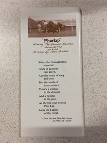
Moonee Valley Race Program, Moonee Valley - A tribute to Phar Lap, April 1992
... 91-97 Boundary Road, North Melbourne, Victoria ...A race meeting held as a tribute to "Phar Lap" - died 5/4/1932Rectangular program 112 pages with sepia photos of "Phar Lap" on front and back. Contains details of races held by the Moonee Valley Racing Club Inc. on Saturday 11 April 1992. Cost of program $2See photos front and back covers -
 Plutarch Project
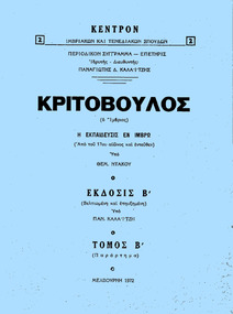
Book - Kritovoulos Book, Κριτόβουλος (ο Ίμβριος), Circa 1972
... 3 Kororoit Creek Road, North Williamstown, Melbourne ...This author P. Kalaitzis was founder and director of the magazine by the name "Σύγγραμμα - Επετηρίς" at the time of publication. He describes here the education situation on the island of Imbros from the 17th Century till the mid-1900s. The book is in the Greek language. It has no illustrations and its 18 pages long. - It was printed by printers D. Giannopoulos - 3 Kororoit Creek Rd., North WilliamstownHistorical significance of the activity of Greeks in Victoria during the periodBook in the Greek language, written by Panayotis Kalaitzis. ΚΕΝΤΡΟΝ Ιμβριακών και Τενεδιακών Σπουδών - Περιοδικόν Συγγραμα - Επετηρίς, Ιδρυτής Διευθυντής Παναγιώτης Δ. Καλαϊτζής. Έκδοσις Β'. (Issue B), Melbourne 1972. Blue soft covergreek, letters, book, imbros, education, βιβλίο -
 Flagstaff Hill Maritime Museum and Village
Functional object - Cotton Wool Roll, Johnson & Johnson, Early 20th century
... 1-5 Khartoum Road, North Ryde, 2133, NSW, Australia ...This cotton wool, used by Dr.William Roy Angus, Surgeon and Oculist, was donated to Flagstaff Hill Maritime Village by his daughter, Bernice McDade. It is part of the “W.R. Angus Collection” that includes historical medical equipment, surgical instruments and material once belonging to Dr Edward Ryan and Dr Thomas Francis Ryan, (both of Nhill, Victoria) as well as Dr Angus’ own belongings. The Collection’s history spans the medical practices of the two Doctors Ryan, from 1885-1926 plus that of Dr Angus, up until 1969. ABOUT THE “W.R.ANGUS COLLECTION” Doctor William Roy Angus M.B., B.S., Adel., 1923, F.R.C.S. Edin.,1928 (also known as Dr Roy Angus) was born in Murrumbeena, Victoria in 1901 and lived until 1970. He qualified as a doctor in 1923 at University of Adelaide, was Resident Medical Officer at the Royal Adelaide Hospital in 1924 and for a period was house surgeon to Sir (then Mr.) Henry Simpson Newland. Dr Angus was briefly an Assistant to Dr Riddell of Kapunda, then commenced private practice at Curramulka, Yorke Peninsula, SA, where he was physician, surgeon and chemist. In 1926, he was appointed as new Medical Assistant to Dr Thomas Francis Ryan (T.F. Ryan, or Tom), in Nhill, Victoria, where his experiences included radiology and pharmacy. In 1927 he was Acting House Surgeon in Dr Tom Ryan’s absence. Dr Angus had become engaged to Gladys Forsyth and they decided he would take time to further his studies overseas in the UK in 1927. He studied at London University College Hospital and at Edinburgh Royal Infirmary and in 1928, was awarded FRCS (Fellow from the Royal College of Surgeons), Edinburgh. He worked his passage back to Australia as a Ship’s Surgeon on the on the Australian Commonwealth Line’s T.S.S. Largs Bay. Dr Angus married Gladys in 1929, in Ballarat. (They went on to have one son (Graham 1932, born in SA) and two daughters (Helen (died 12/07/1996) and Berenice (Berry), both born at Mira, Nhill ) Dr Angus was a ‘flying doctor’ for the A.I.M. (Australian Inland Ministry) Aerial Medical Service in 1928 . The organisation began in South Australia through the Presbyterian Church in that year, with its first station being in the remote town of Oodnadatta, where Dr Angus was stationed. He was locum tenens there on North-South Railway at 21 Mile Camp. He took up this ‘flying doctor’ position in response to a call from Dr John Flynn; the organisation was later known as the Flying Doctor Service, then the Royal Flying Doctor Service. A lot of his work during this time involved dental surgery also. Between 1928-1932 he was surgeon at the Curramulka Hospital, Yorke Peninsula, South Australia. In 1933 Dr Angus returned to Nhill where he’d previously worked as Medical Assistant and purchased a share of the Nelson Street practice and Mira hospital from Dr Les Middleton one of the Middleton Brothers, the current owners of what was once Dr Tom Ryan’s practice. Dr L Middleton was House Surgeon to the Nhill Hospital 1926-1933, when he resigned. [Dr Tom Ryan’s practice had originally belonged to his older brother Dr Edward Ryan, who came to Nhill in 1885. Dr Edward saw patients at his rooms, firstly in Victoria Street and in 1886 in Nelson Street, until 1901. The Nelson Street practice also had a 2 bed ward, called Mira Private Hospital ). Dr Edward Ryan was House Surgeon at the Nhill Hospital 1884-1902 . He also had occasions where he successfully performed veterinary surgery for the local farmers too. Dr Tom Ryan then purchased the practice from his brother in 1901. Both Dr Edward and Dr Tom Ryan work as surgeons included eye surgery. Dr Tom Ryan performed many of his operations in the Mira private hospital on his premises. He too was House Surgeon at the Nhill Hospital 1902-1926. Dr Tom Ryan had one of the only two pieces of radiology equipment in Victoria during his practicing years – The Royal Melbourne Hospital had the other one. Over the years Dr Tom Ryan gradually set up what was effectively a training school for country general-practitioner-surgeons. Each patient was carefully examined, including using the X-ray machine, and any surgery was discussed and planned with Dr Ryan’s assistants several days in advance. Dr Angus gained experience in using the X-ray machine there during his time as assistant to Dr Ryan. Dr Tom Ryan moved from Nhill in 1926. He became a Fellow of the Royal Australasian College of Surgeons in 1927, soon after its formation, a rare accolade for a doctor outside any of the major cities. He remained a bachelor and died suddenly on 7th Dec 1955, aged 91, at his home in Ararat. Scholarships and prizes are still awarded to medical students in the honour of Dr T.F. Ryan and his father, Dr Michael Ryan, and brother, John Patrick Ryan. ] When Dr Angus bought into the Nelson Street premises in Nhill he was also appointed as the Nhill Hospital’s Honorary House Surgeon 1933-1938. His practitioner’s plate from his Nhill surgery states “HOURS Daily, except Tuesdays, Fridays and Saturday afternoons, 9-10am, 2-4pm, 7-8pm. Sundays by appointment”. This plate is now mounted on the doorway to the Port Medical Office at Flagstaff Hill Maritime Village, Warrnambool. Dr Edward Ryan and Dr Tom Ryan had an extensive collection of historical medical equipment and materials spanning 1884-1926 and when Dr Angus took up practice in their old premises he obtained this collection, a large part of which is now on display at the Port Medical Office at Flagstaff Hill Maritime Village in Warrnambool. During his time in Nhill Dr Angus was involved in the merging of the Mira Hospital and Nhill Public Hospital into one public hospital and the property titles passed on to Nhill Hospital in 1939. In 1939 Dr Angus and his family moved to Warrnambool where he purchased “Birchwood,” the 1852 home and medical practice of Dr John Hunter Henderson, at 214 Koroit Street. (This property was sold in1965 to the State Government and is now the site of the Warrnambool Police Station. ). The Angus family was able to afford gardeners, cooks and maids; their home was a popular place for visiting dignitaries to stay whilst visiting Warrnambool. Dr Angus had his own silk worm farm at home in a Mulberry tree. His young daughter used his centrifuge for spinning the silk. Dr Angus was appointed on a part-time basis as Port Medical Officer (Health Officer) in Warrnambool and held this position until the 1940’s when the government no longer required the service of a Port Medical Officer in Warrnambool; he was thus Warrnambool’s last serving Port Medical Officer. (The duties of a Port Medical Officer were outlined by the Colonial Secretary on 21st June, 1839 under the terms of the Quarantine Act. Masters of immigrant ships arriving in port reported incidents of diseases, illness and death and the Port Medical Officer made a decision on whether the ship required Quarantine and for how long, in this way preventing contagious illness from spreading from new immigrants to the residents already in the colony.) Dr Angus was a member of the Australian Medical Association, for 35 years and surgeon at the Warrnambool Base Hospital 1939-1942, He served as a Surgeon Captain during WWII1942-45, in Ballarat, Victoria, and in Bonegilla, N.S.W., completing his service just before the end of the war due to suffering from a heart attack. During his convalescence he carved an intricate and ‘most artistic’ chess set from the material that dentures were made from. He then studied ophthalmology at the Royal Melbourne Eye and Ear Hospital and created cosmetically superior artificial eyes by pioneering using the intrascleral cartilage. Angus received accolades from the Ophthalmological Society of Australasia for this work. He returned to Warrnambool to commence practice as an ophthalmologist, pioneering in artificial eye improvements. He was Honorary Consultant Ophthalmologist to Warrnambool Base Hospital for 31 years. He made monthly visits to Portland as a visiting surgeon, to perform eye surgery. He represented the Victorian South-West subdivision of the Australian Medical Association as its secretary between 1949 and 1956 and as chairman from 1956 to 1958. In 1968 Dr Angus was elected member of Spain’s Barraquer Institute of Barcelona after his research work in Intrasclearal cartilage grafting, becoming one of the few Australian ophthalmologists to receive this honour, and in the following year presented his final paper on Living Intrasclearal Cartilage Implants at the Inaugural Meeting of the Australian College of Ophthalmologists in Melbourne In his personal life Dr Angus was a Presbyterian and treated Sunday as a Sabbath, a day of rest. He would visit 3 or 4 country patients on a Sunday, taking his children along ‘for the ride’ and to visit with him. Sunday evenings he would play the pianola and sing Scottish songs to his family. One of Dr Angus’ patients was Margaret MacKenzie, author of a book on local shipwrecks that she’d seen as an eye witness from the late 1880’s in Peterborough, Victoria. In the early 1950’s Dr Angus, painted a picture of a shipwreck for the cover jacket of Margaret’s book, Shipwrecks and More Shipwrecks. She was blind in later life and her daughter wrote the actual book for her. Dr Angus and his wife Gladys were very involved in Warrnambool’s society with a strong interest in civic affairs. Their interests included organisations such as Red Cross, Rostrum, Warrnambool and District Historical Society (founding members), Wine and Food Society, Steering Committee for Tertiary Education in Warrnambool, Local National Trust, Good Neighbour Council, Housing Commission Advisory Board, United Services Institute, Legion of Ex-Servicemen, Olympic Pool Committee, Food for Britain Organisation, Warrnambool Hospital, Anti-Cancer Council, Boys’ Club, Charitable Council, National Fitness Council and Air Raid Precautions Group. He was also a member of the Steam Preservation Society and derived much pleasure from a steam traction engine on his farm. He had an interest in people and the community He and his wife Gladys were both involved in the creation of Flagstaff Hill, including the layout of the gardens. After his death (28th March 1970) his family requested his practitioner’s plate, medical instruments and some personal belongings be displayed in the Port Medical Office surgery at Flagstaff Hill Maritime Village, and be called the “W. R. Angus Collection”.The W.R. Angus Collection is significant for still being located at the site it is connected with, Doctor Angus being the last Port Medical Officer in Warrnambool. The collection of medical instruments and other items and equipment is culturally significant, being an historical example of medicine from late 19th to mid-20th century. Dr Angus assisted Dr Tom Ryan, a pioneer in the use of X-rays and in ocular surgery.Box of cotton wool. The cotton wool sheet is covered in blue tissue paper that has been rooled tightly and stored within a rectangular blue cardboard box. The box has white printed text on one side and a coloured paper label on another side. The text includes instructions for use. Made by Johnson & Johnson Pty Ltd, Sydney. The object is part of the W.R. Angus Collection.'Red Chain Cotton. 1 Pound Interleaved. Johnson & Johnson Pty Ltd, Sydney. Sterilized after packaging. Made in Australia. Absorbent.' 'To open, cut along the perforation. To close tuck-in flap. This cotton is of superior grade specially made for wound and surgical purposes. It will also be found useful in the household, office or factory and as a general toilet accessory.'flagstaff hill maritime museum and village, great ocean road, shipwreck coast, cotton wool, medical, johnson & johnson, red chain cotton, w.r. angus -
 Kew Historical Society Inc
Photograph - Flooding of the Yarra River in North Kew, 1934
... Verso: WILLSMERE ROAD NORTH KEW / Stamped 3 163... -- north kew floods -- 1934 natural disasters -- kew willsmere road ...North Kew, now divided between Kew and Kew East, bordered the Yarra River. As such, it was a region subject to flooding in the Yarra Valley. Development beyond this point (ie Kellett Grove) was limited by the City of Kew's planning regulations. Prior to urban development, the area since European settlement and the first land sales in the district in the 1840s, had been used for dairy farming. Small sepia snapshot of floodwaters taken from near Willsmere Road, in what was then known as North Kew. The point of view is looking towards Fairfield. In the foreground are two figures viewing a group in a rowboat in the middle of the flooded river. Semi-submerged street lighting indicates that entire streets had been. overwhelmed by the flood waters. Verso: WILLSMERE ROAD NORTH KEW / Stamped 3 163yarra river -- north kew, floods -- yarra valley, floods -- north kew, floods -- 1934, natural disasters -- kew, willsmere road -
 Melton City Libraries
Photograph, Old Gum Toolern Creek, Unknown
... Old Gum Toolern Creek from North side, Main Road. ... Landscapes of significance Old Gum Toolern Creek from North side ...Old Gum Toolern Creek from North side, Main Road. landscapes of significance -
 Whitehorse Historical Society Inc.
Photograph, Whitehorse Road, Mitcham - Service Road, 1/10/2000 12:00:00 AM
... Coloured photograph of north Service Road in Whitehorse... street mitcham Coloured photograph of north Service Road ...Coloured photograph of north Service Road in Whitehorse Road, Mitcham, looking west to shop and Service Station on the corner of Alexander Street Mitcham.service roads, whitehorse road mitcham, alexander street, mitcham -
Whitehorse Historical Society Inc.
Map, Nunawading Shire, 1892
... (Blackburn) from north of Whitehorse Road to Highbury Road, 2nd map... boundary. One map (Blackburn) from north of Whitehorse Road.... One map (Blackburn) from north of Whitehorse Road to Highbury ...Photocopy of an enlargement of map of Shire of Nunawading showing landowners in 1892.Photocopy of an enlargement of map of Shire of Nunawading showing landowners in 1892. Covers Middleborough Road to Ringwood boundary. One map (Blackburn) from north of Whitehorse Road to Highbury Road, 2nd map (Mitcham) Bulleen to south of Canterbury Road; 3rd map Whitehorse Road to Highbury Road.Photocopy of an enlargement of map of Shire of Nunawading showing landowners in 1892. maps, shire of nunawading, blackburn, blackburn south, nunawading, forest hill, vermont, mitcham, vermont south