Showing 11377 items
matching on the map
-
 Whitehorse Historical Society Inc.
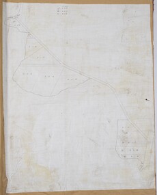
Document, Bicentennial Leadlight Mural
Working drawings and cartoons used in the making of the Bicentennial Leadlight Mural installed in the Nunawading Arts Centre in 1988.Working drawings and cartoons used in the making of the Bicentennial Leadlight Mural installed in the Nunawading Arts Centre in 1988. Located on top of the Map CabinetWorking drawings and cartoons used in the making of the Bicentennial Leadlight Mural installed in the Nunawading Arts Centre in 1988.bicentennial leadlight mural, bi-centennial -
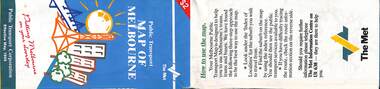 Melbourne Tram Museum
Map, Public Transport Corporation (PTC), "Public Transport Map of Melbourne", 5/1995
Map Includes description of tram and bus routes, private bus routes, and rail lines. Has contact details for bookings and lost property etc and how to use the map. Gives details of the ticketing system, along with photographs of the various modes. Dated May 1995 with a stylised image of some of Melbourne's landmarks on the cover. Published by the Public Transport Corporation.Yields information about Melbourne public transport services in 1995.Fold out map (36 sections 9 across x 4 deep), "Public Transport Map", coloured of Melbourne's Tram and Bus routes, route numbers, rail lines, detailed for the central part of Melbourne and the outer Metropolitan services.tramways, melbourne, tram services, bus services, maps, railways -
Lorne Historical Society
Map - Subdivision Map, J Batten Lithos, Plan of West Lorne Loutitt Bay Allotments IV and V
One of the early subdivision maps of Lorne.Black and white printed map on cream paper. The map shows allotments from the Erskine River to the Grand Pacific with an inset of allotments between Smith and Otway Streets. Allotments have the owners names.. The sea baths, Cobb and Co stables , Mountjoys Hotel, the Church of England, the telegraph line to Geelong and the jetty are also marked.lorne, subdivisions, -
Whitehorse Historical Society Inc.
Article, 'Twin' Teaching at New School, 9/06/1976 12:00:00 AM
The new Primary School proposed at Livingstone Road, Vermont SouthThe new Primary School proposed at Livingstone Road, Vermont South, would be designed for 'closed' and 'open' teaching methods. With map.The new Primary School proposed at Livingstone Road, Vermont Southprimary schools, vermont south primary school, walton, trevor, binaisse, v., cocking, b., knight, b., newsome, m., wickenden, l., head, p. -
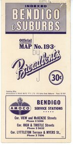 Bendigo Historical Society Inc.
Map - Three Road Maps of Bendigo, 1962
George Robert Broadbent (1863-1947), cyclist and map publisher, was born on 3 November 1863 at Ashby near Geelong, Victoria, son of George Adam Broadbent, Lancashire-born draper, and his wife Elizabeth, née Ruffhead. When the family moved to North Melbourne Broadbent attended the Errol Street school, followed his father's trade, and became an early cycling and cycle-racing enthusiast. At various times Broadbent held most Victorian and Australian road records, and two of his performances on solid tyres—203 miles (327 km) in 24 hours on a penny farthing, and 100 miles (161 km) in 6 hours 20 minutes on a 'safety' bicycle—were never bettered. He established records for all distances between 130 and 220 miles (209 and 354 km), and for all times between 8 and 12 hours, at the Exhibition Grounds track in May 1894, and road records for 50 and 100 miles (80 and 161 km) in October 1896. The Australian Cyclist acknowledged him 'the finest road rider that Australia has ever produced'. A foundation councillor of the League of Victorian Wheelmen in October 1893, Broadbent contested the first Warrnambool-Melbourne race in 1895, and was active in the Good Roads Movement. Next year he issued a road map of Victoria, 'prepared … after some sixteen years riding and touring in all parts of the Colony', which indicated general topography, distances, and roads classified as 'good', 'fair' or 'ridden with difficulty'. It was to become Victoria's standard map, and the basis of a continuous publishing programme by Broadbent's Official Road Guides Co.Three Road Maps of Bendigo, Bendigo and Suburbs, Bendigo and Eaglehawk. Two fold out maps printed in colour and produced by Broadbent's Road Maps Pty. Ltd. 475 Collins Street Melbourne. One map printed by Bolton's Bendigo.history, bolton's, bendio broadbent maps -
 Melbourne Tram Museum
Map, P. Sohns, "Strassenbahn Melbourne Gleisplan", 10-9-1992
Map of Melbourne's tramway system prepared for a German audience - as at 28-5-1992. Shows the track layout, crossovers, depots, route numbers, railway/tramway level crossings, terminus details, road names and a CBD insert. Prepared by P Sohns of Germany - dated 10-9-1992.Yields information Melbourne tramways and routes in 1992.Map - A2 sheet folded to A4.tramways, maps, melbourne, germany -
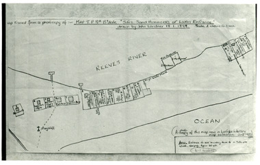 Lakes Entrance Historical Society
Photograph - New Works Plan, 1898
Map traced from a photocopy of :- Map TP8A Bairnsdale. 'Site. Sand Hummocks of Lakes Entrance'. Drawn by John Lardner 18 January 1898. Scale two chains to one inch. ( A photocopy of this map in Latrobe Library map collection, June 1983)Black and white photograph showing sketch map of 1898 by John Lardner Plan of Sites - sand hummocks. Drawing shows sites of buildings at entrance along Cunninghame Arm shoreline at Lakes Entrance, Victoria.land settlement, plan -
 Eltham District Historical Society Inc
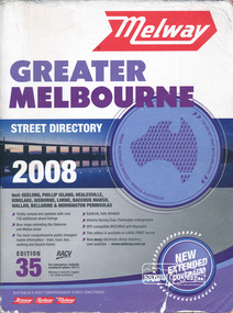
Book, Melway Greater Melbourne street directory 2008 : including Geelong, Phillip Island, Healesville, Kinglake, Gisborne, Lorne, Bacchus March, Wallan, Bellarine & Mornington Peninsulas; Edition 35, 2008, 2007
Edition 35. 2008 Coloured detailed maps accessed by a street or location index. Cover: Totally revised and updated with over 730 additional street listings, new maps extending the Gisbourne and Wallan areas. The most comprehensive public transport routes information - train, tram, bus, walking and bicycle tracks. Eastlink fully detailed, Victoria Racing Club, Flemington enlargement, GPS compatible WGS/MGA Grid displayed, This editon is available in LARGE PRINT format, new eway electronic street directory now available - www.melway.com.au Special feature: New Hierachy of Roads Street directory, coloured maps, indexes, 1201 pagesstreets,roads,melbourne,map,melway -
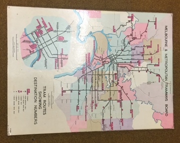 Melbourne Tram Museum
Map, Melbourne & Metropolitan Tramways Board, Del J. Chau, "Tram Routes showing destination numbers", 1972
Titled "Tram Routes showing destination numbers". Map dated 1972, showing routes with route numbers, including short working, names of main destinations, roads, railway stations and rail lines, municipalities, rivers, scales, city section in detail, depots and Sunday only services. In bottom right hand corner has number P.14431, Del J. Chau 1972. The original has been altered to show the Bundoora, La Trobe University and East Burwood lines and the change to Airport West. Type of map that was placed on the rear of the driver's doors of a W Class tramcar.Demonstrates a MMTB produced map used in trramcars.Full colour map or poster printed on heavy cardboard.trams, tramways, mmtb, map, routes -
 Bacchus Marsh & District Historical Society
Map, O'Hagan v Shire of Bacchus Marsh, Allotment 5, Sec 16, Parish of Korkuperrimul
The purpose for this map being created or the date when it was made has not been established. It appears to be documentation relating to a legal dispute by a landowner named O'Hagan and the Shire of Bacchus Marsh. Features identified on the map are allotment 5, section 16, Parish of Korkuperrimul, a 'cultivation paddock', a section of the Werribee River, the path of a section of a 'Main Channel', and a barrier or filled in section across the Werribee River called 'Lee's Filling'. The O'Hagan is likely to be Patrick O'Hagan, 1829-1914 who arrived in Bacchus Marsh in 1864 and was a prominent citizen and landowner in the area for many years until his death in 1914.Single page map showing allotment 5, section 16 in the Parish of Korkuperrimul, Scale 4 chains to inch. Part of a set of maps which are pasted into a bound volume containing 76 maps or plans in total. High resolution digital image stored on BMDHS computer network. Stamped: Munzt, Bace and Muntz, Civil Engineers and Licensed Surveyors , 388 Collins Streetbacchus marsh victoria maps, water supply structures and establishments, watercourses -
 City of Kingston
Pamphlet - Colour, Moorabbin News Print, Auction = Sale Heather Grove Estate, c. 1914
Sales plan for land in the suburb of Cheltenham, bounded by Tulip Grove and Heather Grove.The developing urban area of Highett within the City of Kingston. This land sale pamphlet illustrates the subdivision of land within the municipality and the changing demographic of the district as new houses are constructed close to infrastructure.Colour pamphlet advertising auction of Heather Grove Estate, Cheltenham. Incorporates a map of the estate bordered by Wickham Road, Railway Parade, Highett Road and Point Nepean Road.Handwritten in grey pencil on subdivision 1: Sold / 20/- Handwritten in grey pencil on subdivision 2: 25/- Handwritten in grey pencil on subdivision 3: 30/- Handwritten in grey pencil on subdivision 4: 110 / 30/- Handwritten in grey pencil on subdivisions 1, 11, 10, 9 and 8: Sold Handwritten in grey pencil beneath 'Heather Grove': 20/- 20/- 20/- 20/- Handwritten in black ink on subdivison 12 and 7: £85 Handwritten in back ink on subdivision 5: £60 Handwritten in back ink on subdivision 6: £65 Handwritten in grey pencil above subdivision map: 1-8-9-10-11 Handwritten in grey pencil above subdivision map: [enclosed in a circle] 12- / £75 Handwritten in grey pencil above subdivision map: [enclosed in a circle] 2 / £85 Handwritten in grey pencil above subdivision map: [enclosed in a circle] 3 / £100 Handwritten in grey pencil above subdivision map: [enclosed in a circle] 4 / £100 Handwritten in grey pencil above subdivision map: [enclosed in a circle] 5 / £60 Handwritten in grey pencil above subdivision map: [enclosed in a circle] 6 / £65 Handwritten in grey pencil above subdivision map: [enclosed in a circle] 7 / £25- Handwritten in grey pencil above subdivision map: [enclosed in a circle] £125 / [indecipherable] Handwritten in grey pencil above subdivision map: 37.00 / 18.10 / 56.80 / 3 / [horizontal line] / 59 8 Handwritten in grey pencil along railway line marking: 21/6 / 12/6 / 13/- / 19/-land sales, estate, cheltenham -
 Peterborough History Group
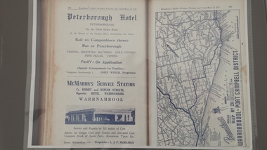
Book - Broadbents Map Warrnambool - Port Campbell district
Advertisement for the significant local building of the time for the Peterborough Hotel. Also contains detailed map of the local roads.The Peterborough Hotel was a significant local building until it burned down in the 1960's.A4 copy of a Broadbent Map which includes an advertisement for the Peterborough Hotel. Approx 1950-1960.peterborough hotel, broadbents guide, peterborough hotel advertisment, john wiber, james irvine -
 Eltham District Historical Society Inc
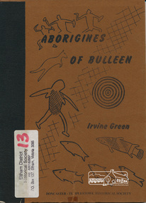
Book, Irvine Green, Aborigines of Bulleen : the history of the Aborigines of the Wurundjeri tribe who inhabited the area which became the city of Doncaster and Templestowe / Irvine Green, 1989
Wurundjeri territorial groupings; subsistence; recreation of daily life; recreation; tribal law; kinship; childhood; religion and mythology; material culture, includes description of bark canoe manufacture; map of significant sites; culture contact and historyPaperback; 40 p. : ill., maps ; 23 cm.ISBN 0947353003aborigines, wurundjeri, social customs, stories, bulleen -
 Greensborough Historical Society
Document, Parliament of Victoria, Ministers & Members search - the Hon. Colin Brooks (Bundoora), 23/04/2021
Biographical details of the Hon. Colin Brooks, MLA for Bundoora, taken from Parliament of Victoria - Ministers and Members website; and, map of the electoral district of Bundoora.2 p. text and colour photograph, with colour map of Bundoora Electoral Districtbrooks family, victoria parliament, colin brooks, bundoora -
 Bacchus Marsh & District Historical Society
Map, Lerderderg Gorge Road Goodmans Creek to Gisborne Road
The date of this map and its purpose has not been established. It was possibly produced to indicate landholders who were impacted by works along the Lerderderg Gorge Road. A single page paper map showing various blocks of land along the route of the Lerderderg Gorge Road near Bacchus Marsh from Goodmans Creek to the point where the road joins with Gisborne Road. The map is pasted into a bound volume containing 76 maps or plans in total. High resolution digital image stored on BMDHS computer network. bacchus marsh victoria maps, lerderderg gorge road bacchus marsh maps -
 Greensborough Historical Society
Map, Melbourne and Metropolitan Board of Works. Survey Division, MMBW, Yarra 2500 / 12.23. Janefield and Kangaroo Point, 1977_10
Melbourne and Metropolitan Board of Works. Yarra 2500 [base map] 12-23, Municipalities of Whittlesea 239 and Diamond Valley 257. No streets marked on this map. Includes Plenty River, Kangaroo Point, Janefield Colony and Janefield Reserve.MMBW Map in 1:2500 [scale] series. Cream parchment with green tape reinforcing on edges and punched holes on left edge.mmbw, melbourne and metropolitan board of works, shire of diamond valley, plenty - maps -
 Wangaratta RSL Sub Branch
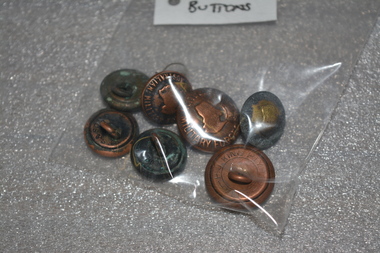
Buttons - Australian Military Forces
Five small and three large buttons. Are a brass colour with Australian Military Forces written around the outside, a map of Australia in the middle with a crown on top.On front: Australian Military Forces. Also has the map of Australia with a crown on top, On back: P.J.King Pty Ltd, Melb. australian army, australia military badges, buttons, australian buttons, australian military forces buttons -
![The Scientific Savant in Nineteenth Century Australia / [by] Australian Academy of Science](/media/collectors/550653872162f11fb04854aa/items/5ed043e1dcf9cd08346b7493/item-media/5ed04634dcf9cd08346b840c/item-fit-380x285.jpg) Kew Historical Society Inc
Kew Historical Society IncBook, Historical Records of Australian Science, The Scientific Savant in Nineteenth Century Australia, 1997
Scientific savant in nineteenth century Australia. 1996 commemorative conferences, Royal Botanic Gardens, Melbourne, Sunday 29th September to Saturday 5th October 1996 held at the University of Melbourne, the scientific savant in 19th century Australia, celebration of the life, times and legacy of Ferdinand von Mueller, program & abstracts23 pages : map ; 30 cm.non-fictionScientific savant in nineteenth century Australia. 1996 commemorative conferences, Royal Botanic Gardens, Melbourne, Sunday 29th September to Saturday 5th October 1996 held at the University of Melbourne, the scientific savant in 19th century Australia, celebration of the life, times and legacy of Ferdinand von Mueller, program & abstractsroyal botanic gardens - melbourne (vic.), ferdinand von mueller -
 Stawell Historical Society Inc
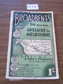
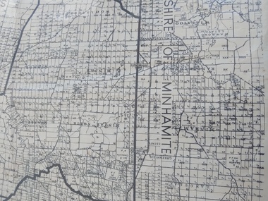
Book, Broadbent directory, Broadbent's Official : Speedo Strip Road Guide, 1943
Maps and descriptions of towns on the Western Highway & Dukes Highway from Melbourne to Adelaide. Sponsored by R.A.C.V and The Victorian Government Tourist BureauCream paper cover back border with green filling with a map from Melbourne to AdelaideBroadbeants Official Speedo Strip guide Melbourne to Adelaidestawell transport -
Clunes Museum
Map - MAP OF TOURELLO LAND HOLDINGS
THERE ARE NO NAMES, NO DATES. IT SEEMS TO BE CUT OFF A BIGGER MAPTWO COPIES OF AN EARLY MAP OF TOURELLO LAND HOLDINGS ONE COPY IS COPIED ON A 4 PAPER AND STUCK TOGETHER WITH STICKY TAPEtourello land holdings, tourello map -
 Peterborough History Group
Map - Shire of Warrnambool
Map of the area, when Peterborough was part of Warrnambool ShireHistoric map of the area when Peterborough was in the Warrnambool ShireA3 size map, larger view of the whole shire of Warrnambool, and includes adjoining Shire Boundaries. Shows individual land allotments.peterborough, warrnambool shire, old maps -
 Dutch Australian Heritage Centre Victoria
Road Map, Nederland
Cleverly folded 1:250,000 road map produced in Dutch, French, German and English containing not only the Dutch road network but also much information of interest to tourists. It is enclosed in a brown imitation leather cover that closes with a stud. Optimal ease of use through patented Falk folding mode.Falk Plan. Road Map. Netherlands. Repeated in Dutch, French and German. -
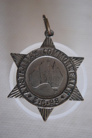 Anglesea and District Historical Society
Medal Commemorative Australian Federation, 1898
Ref/ Car. 1898/2. Star shapped medal issued in 1898 tocommemorate the forthcoming Commonweath of Australia - a map of Australia in the centre divided into six states/colonies, each state represented by a ray - inscribed around the circumferance and with provision for a pin to be attached with hole and metal ring on the top ray of star. Back of medal perfectly plain.Map of Australia within ring. Around ring: "AUSTRALIA'S COMMONWEALTH" *3.6.98*medal, commemorative, australian federation -
 Greensborough Historical Society
Book - Atlas, Victoria. Department of Sustainability and Environment, Melbourne atlas, 2006_
The purpose of the Melbourne Atlas is to give a spatial view of physical , environmental, social, economic and cultural aspects of Melbourne which can be used in planning. It contains maps and graphs depicting many aspects of life in Melbourne. A snapshot of life in Melbourne in 2006.Various paging, text, illus., colour maps. Wire binding.melbourne, maps, town planning, social conditions -
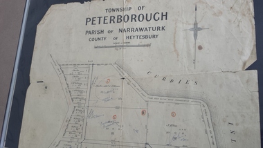 Peterborough History Group
Map - Map of the township of Peterborough, Township of Peterborough
Same map as 4012 but printed names are easier to read. Hand drawn arrows show the road now built connecting Macs St to the Warrnambool RdShows early layout of the town and names of landownersgovernment map of the township of Peterborough with handwritten notes on it. Includes the names of the landowners 1931some hand drawn arrows.peterborough, old maps, maps -
 Lorne Historical Society
Map, F W Niven Lithos, The Mountjoy Lorne Estate, 1889
In 1888 a company was formed to acquire and subdivide the land of the Mountjoy Brothers. The land totaled 197 acres and included Erskine House. The land colored red was that of the Mountjoys. The subdivision map was printed in 1889A paper map of the Mountjoy Estate Lorne , showing allotments, with their owners, and naming land use. It has four black and white line drawings , Erskine House, Mountain View’s, the Rapids, Erskine House sea view and Erskine Falls. The map is largely black and white with red and blue colouring. The map is mstuck to brown paper. lorne, subdivision map, erskine house, mountjoy brothers, -
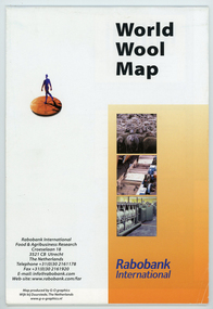 National Wool Museum
Map - World Wool Map, Rabobank International, c.2002
Part of a collection of books, manuals, photographs, letters and clothing relating to the working life of Stuart Ascough. Stuart's career in the wool industry spanned over 43 years from 1960 to 2003 in various roles including Topmaking Plant Manager at Courtaulds Ltd. in Spennymore, U.K., Operations Manager at Port Phillip Mills in Williamstown Victoria, Marketing Executive, Early Stage Wool Processing at the International Wool Secretariat Melbourne, Australia and General Manager of Victoria Wool Processors Pty. Ltd. in Laverton North, Victoria. Throughout his career Stuart travelled extensively, and in the 1990s worked at many topmaking mills in China on quality improvement projects. He also provided technical advice and training at mills in India, Ukraine, Lithuania, Kyrgyzstan, Russia, Latvia, Byelorussia and other parts of Europe and Asia.Folded world map showing statistics, images and graphics relating to wool in the 1990's.front: World Wool Map / Rabobank / International / Rabobank International / Food & Agricultural Research / Croeselaan 18 / 3521 CB Utrecht / The Netherlands / Telephone +31 (0) 30 2161178 / Fax +31 (0) 30 2161920 / E-mail: [email protected] / Web-site:www.rabobank.com/far / Map produced by G-O graphics / Wijk bij Duurstede, The Netherlands / www.g-o-graphics.nlstuart ascough, international wool secretariat, victoria wool processors, port phillip mills pty ltd, topmaking, career, wool industry, training, technical advice, mills, map -
Tatura Irrigation & Wartime Camps Museum
Box of Maps, early 20th century
Maps are of the following: Toolamba (2), Toolamba West (2), Undera (2), North Murchison, Coomboona (2), Mooroopna, Waranga, Kyabram East, Girgarree East, Mooroopna West (2), Tatura and Goulburn irrigation district (pre 1956).Box containing maps of individual parishes in the county of Rodney, showing early selections. Also one of early Tatura townships with owners of many house blocks. 17 maps.each one is labelled with the parish (Toolamba, Tatura, , etc.) -
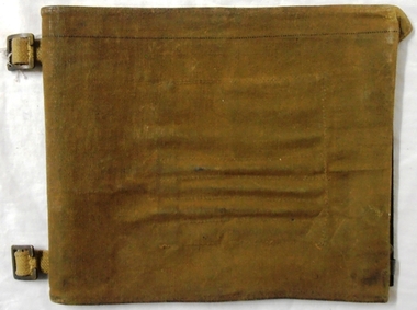 8th/13th Victorian Mounted Rifles Regimental Collection
Functional object - Map case, 1942
Fine example of officer's accessory to hold map securely and protected from weather.Fine example of officer's accessorily to hold map securely and protected from weather.Hard fibre board panel with metal clips securing clear Perspex sheet covering map; canvas flap attached to one edge of board folding over and secured to other side of board with two metal press studs. Underside of flap has pockets for chinagraph marking pencils. Map is RACV road map of area southwest of Eildon Victoria probably a training area for 13th Motor Regiment. Also has two buckles to allow attachment to user's webbing.Stamped on cover flap "CG Hartley & Co 1942"map, motor, 13th, gippsland -
Whitehorse Historical Society Inc.
Pamphlet, Antonio Park, 1980?
Antonio Park: a valuable remnant of natural bush :Antonio Park: a valuable remnant of natural bush : leaflet for visitors including map and notes on the park's history, flora and fauna.Antonio Park: a valuable remnant of natural bush :antonio park, mitcham