Showing 1249 items matching "permit"
-
![Photograph, Centenary Celebrations, Willsmere [Kew] Mental Hospital, 1972, 1972](/media/collectors/550653872162f11fb04854aa/items/5e94044021ea671558ab43e3/item-media/5e94045b21ea671558ab67ad/item-fit-380x285.jpg) Kew Historical Society Inc
Kew Historical Society IncPhotograph, Centenary Celebrations, Willsmere [Kew] Mental Hospital, 1972, 1972
This photograph is part of a series taken at the Willsmere (Kew) Mental Hospital. The photographs were gifted to the Kew Historical Society in 2018 by Rosemary Barnes. The photos had been in the possession of her former husband, Dr Fred Stamp, the last medical superintendent of the hospital. In 2019, the photographs were transferred to the State Archives as Permanent Government Records, as the Society is only entitled as a Class-B Place of Deposit to hold Temporary Government Records. The Society was permitted to keep and publish a digital copy of each photograph. Many of the photographs include information on the reverse about individuals or locations. Where this is the case, these have been published here as images that can be viewed in the picture carousel. Permission for third parties to reproduce this record must be granted by the Public Record Office Victoria.One of a series of photographs of the centenary celebrations at the Willsmere Mental Hospital in 1972. willsmere mental hospital, willsmere unit, kew mental hospital, kew lunatic asylum, willsmere hospital -
![Photograph, Centenary Celebrations, Willsmere [Kew] Mental Hospital, 1972, 1972](/media/collectors/550653872162f11fb04854aa/items/5e94046421ea671558ab74b8/item-media/5e94047f21ea671558ab87f9/item-fit-380x285.jpg) Kew Historical Society Inc
Kew Historical Society IncPhotograph, Centenary Celebrations, Willsmere [Kew] Mental Hospital, 1972, 1972
This photograph is part of a series taken at the Willsmere (Kew) Mental Hospital. The photographs were gifted to the Kew Historical Society in 2018 by Rosemary Barnes. The photos had been in the possession of her former husband, Dr Fred Stamp, the last medical superintendent of the hospital. In 2019, the photographs were transferred to the State Archives as Permanent Government Records, as the Society is only entitled as a Class-B Place of Deposit to hold Temporary Government Records. The Society was permitted to keep and publish a digital copy of each photograph. Many of the photographs include information on the reverse about individuals or locations. Where this is the case, these have been published here as images that can be viewed in the picture carousel. Permission for third parties to reproduce this record must be granted by the Public Record Office Victoria.One of a series of photographs of the centenary celebrations at the Willsmere Mental Hospital in 1972. willsmere mental hospital, willsmere unit, kew mental hospital, kew lunatic asylum, willsmere hospital -
![Photograph, Centenary Celebrations, Willsmere [Kew] Mental Hospital, 1972, 1972](/media/collectors/550653872162f11fb04854aa/items/5e9404a521ea671558abb787/item-media/5e9404d121ea671558abdfb6/item-fit-380x285.jpg) Kew Historical Society Inc
Kew Historical Society IncPhotograph, Centenary Celebrations, Willsmere [Kew] Mental Hospital, 1972, 1972
This photograph is part of a series taken at the Willsmere (Kew) Mental Hospital. The photographs were gifted to the Kew Historical Society in 2018 by Rosemary Barnes. The photos had been in the possession of her former husband, Dr Fred Stamp, the last medical superintendent of the hospital. In 2019, the photographs were transferred to the State Archives as Permanent Government Records, as the Society is only entitled as a Class-B Place of Deposit to hold Temporary Government Records. The Society was permitted to keep and publish a digital copy of each photograph. Many of the photographs include information on the reverse about individuals or locations. Where this is the case, these have been published here as images that can be viewed in the picture carousel. Permission for third parties to reproduce this record must be granted by the Public Record Office Victoria.One of a series of photographs of the centenary celebrations at the Willsmere Mental Hospital in 1972. willsmere mental hospital, willsmere unit, kew mental hospital, kew lunatic asylum, willsmere hospital -
![Photograph, Centenary Celebrations, Willsmere [Kew] Mental Hospital, 1972, 1972](/media/collectors/550653872162f11fb04854aa/items/5e9404dc21ea671558abe6c7/item-media/5e9404fe21ea671558ac0b46/item-fit-380x285.jpg) Kew Historical Society Inc
Kew Historical Society IncPhotograph, Centenary Celebrations, Willsmere [Kew] Mental Hospital, 1972, 1972
This photograph is part of a series taken at the Willsmere (Kew) Mental Hospital. The photographs were gifted to the Kew Historical Society in 2018 by Rosemary Barnes. The photos had been in the possession of her former husband, Dr Fred Stamp, the last medical superintendent of the hospital. In 2019, the photographs were transferred to the State Archives as Permanent Government Records, as the Society is only entitled as a Class-B Place of Deposit to hold Temporary Government Records. The Society was permitted to keep and publish a digital copy of each photograph. Many of the photographs include information on the reverse about individuals or locations. Where this is the case, these have been published here as images that can be viewed in the picture carousel. Permission for third parties to reproduce this record must be granted by the Public Record Office Victoria.One of a series of photographs of the centenary celebrations at the Willsmere Mental Hospital in 1972. willsmere mental hospital, willsmere unit, kew mental hospital, kew lunatic asylum, willsmere hospital -
![Photograph, Centenary Celebrations, Willsmere [Kew] Mental Hospital, 1972, 1972](/media/collectors/550653872162f11fb04854aa/items/5e94050921ea671558ac0fef/item-media/5e94053621ea671558ac3c4c/item-fit-380x285.jpg) Kew Historical Society Inc
Kew Historical Society IncPhotograph, Centenary Celebrations, Willsmere [Kew] Mental Hospital, 1972, 1972
This photograph is part of a series taken at the Willsmere (Kew) Mental Hospital. The photographs were gifted to the Kew Historical Society in 2018 by Rosemary Barnes. The photos had been in the possession of her former husband, Dr Fred Stamp, the last medical superintendent of the hospital. In 2019, the photographs were transferred to the State Archives as Permanent Government Records, as the Society is only entitled as a Class-B Place of Deposit to hold Temporary Government Records. The Society was permitted to keep and publish a digital copy of each photograph. Many of the photographs include information on the reverse about individuals or locations. Where this is the case, these have been published here as images that can be viewed in the picture carousel. Permission for third parties to reproduce this record must be granted by the Public Record Office Victoria.One of a series of photographs of the centenary celebrations at the Willsmere Mental Hospital in 1972. willsmere mental hospital, willsmere unit, kew mental hospital, kew lunatic asylum, willsmere hospital -
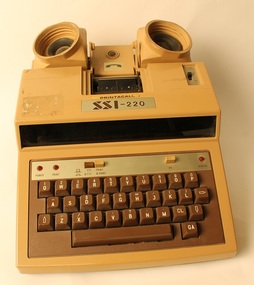 Deaf Children Australia
Printacall TTY Printer, Specialized Systems, Inc, 1970's
Light brown top with dark brown base telephone keyboard. Made of plastic with sockets for the handpiece of a phone, a QWERTY keyboard and small (5cmW) printer, possibly with a screen. Used to take and send telphone calls. Uses batteries and has a handle for carrying. On top: "PRINTACALL/SSI-220" On back: "SSI / INNOVATIONS IN COMMUNICATIONS" On bottom: in middle of metal plaque "SSI-220 / Power: DC 6V/ Type "C" x 4 / (RECHARGEABLE BATTERY) / SPECIALIZED SYSTEMS, INC. / SAN DIEGO, CALIFORNIA / MADE IN JAPAN / SERIAL NO. 02478" On sticker on back: "MODEL. SSI-220 / SERIAL NO. 84840001 / Printacall Pty. Ltd. (02) 2648104 / P.O BOX A623 Sydney South 2000 N.S.W. Australia." Inscribed on R side: "HEIDELBERG HIGH SCHOOL / HEARING IMPAIRED UNIT NO 3" Label on L side: "TELECOM AUSTRALIA / Permit No 08216 103/2" -
 Bendigo Historical Society Inc.
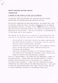
Document - BENDIGO HERITAGE ADVISORY SERVICE: REPORT TO COUNCIL, JAN 1987
Bendigo Heritage Advisory Service - Report to Council, Jan 1987, This appears to be a draft report as there are handwritten changes on a number of pages. Report is set out in the form of an Introduction and a Summary. Advisory Service comprised Heritage Advisor, Andrew Ward; Bendigo and Eaglehawk Councils; National Trust; Bendigo Historical Society; MPE and Historic Buildings Council; community representatives??; City of Bendigo - Cr Rod Fyffe, Mr Norm Cameron. Recommendations - Changes to Planning Scheme; Policy encouraging reuse of Buildings; Adoption of Action Plans; Council to encourage Heritage based Tourism; Appropriate development applications encouraged. Attached are seven short papers on specific aspects of heritage planning - 1. a Statement of Bendigo's Significance; 2. The economic importance of heritage planning; 3. Planning Scheme heritage provisions; 4. Procedures for permits; 5. Action plans for Bendigo precincts; 6. Reuse of buildings; 7. Government incentives for heritage conservation., (this last one not attached as ''Already Circulated''.Bendigo Heritage Advisory Servicebendigo, council, heritage advisory committee, bendigo and eaglehawk councils. national trust, bendigo historical society, historic building council. reuse of buildings. -
 Bendigo Historical Society Inc.
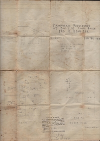
Document - JOAN LEVERSHA COLLECTION: HOUSE PLANS 12 BOLT STREET, LONG GULLY
Various documents relating to the plan building of house at 12 Bolt Street, Long Gully. 1)Plan of proposed residence at Bolt Street, Long Gully for D. Dean Esq. job No. 133R plan drawn by A.S. and R.A. Eggleston Architects, 186 Mitchell Street, Bendigo. Stamp of the City of Bendigo approving the plan, signed by an official and dated 27/07/1950. 2) inside plan drawn in pencil and blue Biro, stamped by City of Bendigo and Bendigo Sewerage Authority. 3) Another drawing of section done in blue Biro. 4) Application for permit to construct No.4746. 5) Two pages on A4 paper written in blue pen, under the title City of Bendigo information for builders in regard to weatherboard buildings, long list of regulations to be followed, stamp of City of Bendigo and signature of D. Dean dated 27/07/1950. 6) small paper with various dimensions. All this documents are in a paper envelope marked Doug, house, 12 Bolt St.house, private, drawings -
 Ballarat Tramway Museum
Document - Letter/s, State Electricity Commission of Victoria (SECV), "Crossing Under Tramway Tracks", 1937
Yields information about the correspondence that was sent to Ballarat from Bendigo about underground services under tram tracks, the changes and the list of the people it was sent to.Set of five documents: Documents 2 and 5 same as Reg Item 4946, but marked up to show changes to the Bendigo docs for the Ballarat situation - in pencil. Cover sheet pinned to the four sheets is a handwritten ink foolscap ruled sheet showing all the addressees that the letter was to be sent to. Other sheets are: Letter on SECV letterhead, "Bendigo Electricity Supply and Tramways", not dated, gives phone number, address, duplicated in black ink, titled "Crossing Under Tramway Tracks", consisting of one foolscap sheet. quarto sheet, as a blank form - application form to install the service. cut sheet - blank form - Permit for Crossings under Tramway Tracks cut sheet - blank form - "Pipe crossings under tramway tracks" See Reg Item 4945 for Ballarat, possibly used as a model for the Ballarat document, given Reg Item 4943 correspondence and see Reg Item 4947 for cover letter for these documents and Reg Item 4946 for the original Bendigo docs.in ink "1" and "2" "3" and "4" on sheets in ink and on sheet 4 - change noted re "Technical Assistant" changed to "Tramway Inspector"trams, tramways, letters, sec, tram track, bendigo -
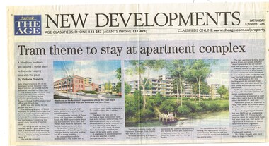 Melbourne Tram Museum
Newspaper, The Age, Progress Press, "Tram theme to stay at apartment complex", 2000
Set of 6 newspaper cuttings about the redevelopment of the site to apartments and the Hawthorn Tram Museum Depot. .1 - The Age - 8 Jan. 2000 - "Tram theme to stay at apartment complex" - announcing the redevelopment and plans for the redevelopment of Hawthorn tram depot. Includes architects impressions. Article by Victoria Gurvich. .2 -The Age - 14/1/2000 - letter to the Editor by Peter Moon - "Tram plan: too big and too ugly". .3 - Press - 21/2/2000 - "Trams on track for 498 years, Depot housing in line with history" - with photo of Mike Ryan and Matt Faubel (old photo) - article by Laeta Antonysen. .4 - ditto - "Outcry over historic site" and "Developers asked for another aspect" .5 - Progress Press - 6/3/2000 - letter re the redevelopment from John Santoro or Power St Hawthorn. .6 - Progress Press - 7/8/2000 - "Green light for tram depot apartments" - about the City of Boroondara issuing the planning permit.trams, tramways, hawthorn tram depot, tram museum, museums, minister for transport, city of boroondara -
 Eltham District Historical Society Inc
Photograph, Fay Bridge, EDHS Heritage Excursion, Edendale Farm, 5 May 2018
May Excursion – Edendale Environs Edendale Community Environment Farm in Gastons Road, Eltham now operates as Nillumbik Council’s environmental centre. The historic homestead has undergone a significant restoration and there is on-going development of the site consistent with its community education purpose. The house and the gateway sculpture “The Fences Act” are covered by a Heritage Overlay in the Nillumbik Planning Scheme. Our May excursion will comprise a walk through the farm property and will radiate to other nearby places of historic interest. These will include the site of the Eltham North Adventure Playground to discuss its history and destruction by fire (see page 1 article). Also nearby is Colemans Corner where the early road system has undergone some unusual changes. If time permits we may visit some other nearby places of interest. - EDHS Newsletter No. 239 April 2018fay bridge collection, 2018-05-05, edendale community farm, edendale farm, eltham district historical society, heritage excursion, activities -
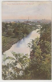 Kew Historical Society Inc
Postcard, River Yarra at Studley Park, Kew, c.1908
Colour-tinted postcard, titled in red upper left: “RIVER YARRA AT STUDLEY PARK, KEW”. On the divided reverse, the card is addressed to “MISS JOLLEY / MELB. TRAM & O[MNIBUS]. CO / BOURKE STREET, MELB”. The sender has dated the card 21.12.08. In the upper right corner, there is a pink Victorian one penny postage stamp; sent from Melbourne on 22DE 08. (The division of the reverse of the postcard, allowing a message to be written on one half and the address on the other, was not permitted in Australia until 1905.) The manufacturer of the postcard is indicated by the initials “W.T.P”, printed in a green floral diamond, printed centre top. This was the trademark of WT Pater, printers & stationers. William Thompson Pater was born in Melbourne in 1861. His business at 271 Little Collins Street offered Christmas cards, booklets, calendars, and leather goods as well as postcards and albums.Hand-tinted postcard of the River Yarra in Studley Park, Kew. The birds-eye view is of a bridge on the Yarra (Johnston Street?) linking Kew and Abbotsford as it appeared in c.1908. On the Abbotsford side of the river, fields lead down to the river, with some remnant trees. The Kew side of the river, in contrast, due to its steep banks, retains its original vegetation. In the distance is industrial development, in what might be Fairfield and Alphington.“RIVER YARRA AT STUDLEY PARK, KEW”river yarra -- kew (vic.), william thompson pater, w.t.p., postcards -- kew, postcards -- studley park, bridges - yarra river -- kew (vic.) -
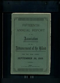 Vision Australia
Administrative record - Text, Fifteenth Annual Report of the Association for the Advancement of the Blind 1910, 1910
Annual report of the Association for the Advancement of the Blind outlined activities and events over the year, including a membership of 276, nearly 1000 visits made to people in their homes with several taking the opportunity to learn Braille, leasing of 'Woodburn' to accommodate those who were unable to provide for themselves or convalescent rather than provide short term financial help, an extension of the Railway Permit was secured so that the holder is able to travel with a guide and pay only one fare on the Brighton Electric Tramway and Williamstown Ferry Boat club, commitment by the Federal Government to extend the invalid pension to blind persons, the Department of Education is improving lighting which will help some children with eye difficulties and the loss of Sir Malcolm McEachern, F.S Grimwade, Mr Quayle and Dr McBurney, (the latter for whom a portrait will be placed in the Home for the Adult Blind due to his professional and personal support of the Association).1 volume of printed material with some illustrationsassociation for the advancement of the blind, annual reports -
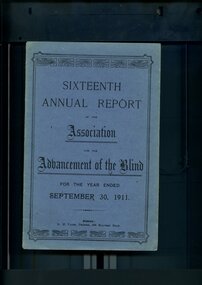 Vision Australia
Administrative record - Text, Sixteenth Annual Report of the Association for the Advancement of the Blind 1911, 1911
Annual report of the Association for the Advancement of the Blind outlined activities and events over the year, including membership of 299, 1000 visits were paid during the year, the Public Works department erected a set of steps from the top of the cliff to the sands so that Home residents may be able to access the beach, Railway Permits will now also be honoured on the Prahran-Malvern Electric Tramway and Bay Excursion Steamers, a concert party toured to Egerton, Ballan, Bacchus Marsh, Myrniong and Toolern Vale for the dual purpose of raising awareness and funds for the Association, Mr A Solomon has been appointed as a second Collector to visit Country Towns and with the support of the wife of the Minister for Public Works, Miss Aston and Miss Munce waited on the Lady Mayoress of Melbourne, gave her full support to organise a fund to purchase the land and buildings in Mair Street for the Association.1 volume of printed material with some illustrationsassociation for the advancement of the blind, annual reports -
 Melbourne Tram Museum
Document - MTOC Rules and Regulations, Melbourne Tramway and Omnibus Co (MTOCo), c1913
Melbourne Tramway and Omnibus Co. Ltd Rules and Regulations by which all operational staff were to abide by. Provides separate sections of rules for Gripmen and Conductors, with Special rules for both roles, collection of fares and use of Bell Punch, transfer and check tickets, Collectors (Conductors acting as collectors on the dummy or grip car), signalmen and shunters. Printed by Sands & McDougall. Date of issue has been damaged by silverfish - Mr H A Wilcox was appointed Secretary in 1909, becoming General Manager in the Tramway Board which succeeded the private company in 1916. Rule 76, page 21 allows for the wearing of the Australian Tramway Employees Association union badge. The Union was recognised by the Company in August 1912 and the wearing of Union badges on watch chains was permitted. A possible date for the document is 1912. See item 6340 for the MTOCo / AETA agreement that was reflected in these rules.Demonstrates a MTOCo cable tram rule book and requirements of its employees.Book - 68 pages + card covers covered in a dark grey cloth, centre stapled.tramways, cable trams, conductors, tickets, grip men, signalmen, shunters, fares, operations, rules -
 Eltham District Historical Society Inc
Document - Property Binder, 729 Main Road, Eltham
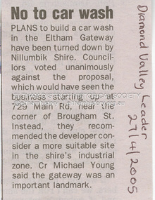
Newspaper article: Diamond Valley Leader, 27 April 2005, No to car wash. Letter 25 July 2005 from Minter Ellison Lawyers attaching VCAT notice of adjournment. Letter 5 September 2005 re Application for review of Application for Review P1036/2005. Letter 6 September 2005 from Apex Building Design Studio to Minter Ellison Lawyers re carwash development. Newspaper article: Diamond Valley Leader 20 February 2007, Gateway 'blob' bid fails test, Nillumbik Council rejected plan for 3 story building, 12 offices, ship, 8 homes. Notice of Decision to Refuse to Grant a Permit, Application 191/2023/02P, Nillumbik Shire Council, 4 Oct 2023 Newspaper advertisement: Leader Associated Newspapers, Eltham Centenary Supplement, March 30, 1971, Mobil Service Centremain road, eltham, property, businesses, carwash, apex design studio, eltham gateway, minter ellison lawyers, mobil service centre (eltham) -
 Bendigo Historical Society Inc.
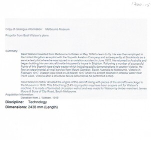
Document - BASIL WATSON COLLECTION: MAN AND AERIAL MACHINES NEWSLETTER ISSUE NO. 40 1994, 1994
On the front page of Man and Aerial Machines a publication for those with a serious interest in the Aeronautical history of Australia. Issue No. 40 ISSN 1037-5120 January to February 1994 is a grey scale of Basil Watson and his Aircraft along with another man standing behind the Aircraft, both men are wearing hats. The biplane has a single propella and along the side of the plane is a ring of three different colours. Underneath is written 'Basil Waton's aircraft at an unknown location and R.A.A.F Museum via John Hopton. The newsletter covers a drawing of Short S.B.5 with 60deg wing sweep and a low set tail plane from Shorts Aircraft since 1900 by C.H. Bames. An article on Basil George Watson also 'The War Aloft, Experiences of Australian Aviator, the latest machines'. 'In his Homebuilt Biplane Aviator Loops and Dive's. 'Bendigo Aviator flies from Melbourne' 'Flight from Bendigo', 'The Aeroplane in War, some recent developments'. 'Castlemaine New Years Day Carnival' An advertisement for Basil Watson to give a demonstration at the Bendigo Racecourse Saturday 2nd December (weather permitting)person, individual, basil watson -
 Falls Creek Historical Society
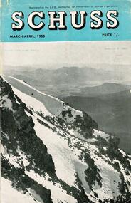
Journal - Schuss Vol. 19. No. 2 March - April 1953
Schuss was advertised as Victoria’s Official Ski Journal It was issued monthly from 1935 to 1961 except during the war when summer issues covered two months. This continued after the war, but it averaged 10 issues annually over its 25 year life. Schuss was published by the Ski Club of Victoria which had a membership of 38 Ski Clubs and demanded to be recognised as the prime authority on skiing in the state. The other 30 ski clubs with 85% of the members disagreed and the politics of skiing became heated. These clubs formed the Federation of Victorian Ski Clubs with their own journal, Ski Horizon. With the establishment of the Victorian Ski Association, Ski-Horizon published its last issue in Nov - Dec. 1955 and the role of the official journal was fully taken over by “Schuss”. This item is significant because it contains stories, images and information documenting the development of the ski industry in Victoria.The journal features stories and events chronicling developments in Victoria and internationally. Items related to the Falls Creek Area in this issue include:- Cover - Features a photo by H.Gibbs titled "Western Cliffs of Mt. Bogong" Page 65 - BOB HYMANS reported news of Falls Creek. At his own Ski School, notable improvements to accommodation have been made and additions to the building itself, which will make it very much more comfortable and serviceable to visitors. Water supply and heating are amongst the items in hand. Bob has acquired a Land Rover which will be a power of assistance to him in maintaining fresh supplies and in servicing his project generally. Kiewa Valley Ski Club members are making splendid progress with the erection of their Lodge. This is the latest building addition in that area and raises the number of clubs resident there to nine. Nissen Ski Tow members intend to operate their tow on the upper slopes of Falls Creek every day during the coming season that conditions permit. They are to be warmly commended on their enterprise. Page 65 - Advertisement for Bob Hymans' Ski School and Lodgeschuss journal, bob hymans, kiewa valley ski club, nissen tow -
 Eltham District Historical Society Inc
Document - News Clipping, Advertiser, Public Outcry at Abbott Veto with 'Reserve Power; 200 residents yell abuse as commissioners give ok to Eltham service station; Advertiser, Tuesday, October 15, p1, 1996
Nillumbik Commissioners used 'reserve power's to permit a controversial Shell service station and Hungry Jackls restaurant development at the former Eltham Shire Office site at 895 Main Road. More than 200 people attended the Council meeting in the public gallery and protested at the decision. 32 personal submissions were made to Council's Planning Special Committee meeting whose members vioted 3-2 against the development. The Committee consisted of the three Nillumbik Commissioners and three community members (Jim Connor, Bronwyn South and Janet Mattiske). Chief Commissioner Don Cordell, a former Shell employee excused himself from voting and the three communbity memebrs voted against the submission. The other two commissioners, Vin Heffernan and Kevin Abbott voted against it. They then immediately closed the meeting and opened a Council meeting lasting just seconds to use special reserve powers to overturn the decision. The demolition of the former Shire of Eltham offices and proposed sale and development driven by the Commissioners for Nillumbik Shire Council brought the community together in substantial protest at the infrigement of ratepayers democratic say in local government and ciommunity assets combined with protests about inappropraite development of Eltham's Gateway. This issue led to the formation of the Eltham Community Action Group which still operates strongly today (2023) on behalf of the community to ensure appropriate development within the community.895 main road, commissioners, dallas price homes, development application, eltham hub, hungry jacks, nillumbik shire council, re-zoning, shell service station, town planning, eltham gateway, eltham gateway action group, eltham shire offices, shillinglaw farm, shillinglaw trees, jim connor collection, dallas howgate, frank burgoyne, robert marshall, nillumbik planning special committee, jim connor, bronwyn south, janet mattiske, don cordell, vin heffernan, kevin abbott -
 Eltham District Historical Society Inc
Document - News Clipping, Jodie Guest, Shrewd tactics row, Diamond Valley News, October 15, p1, 1996
Nillumbik Commissioners used 'reserve power's to permit a controversial Shell service station and Hungry Jackls restaurant development at the former Eltham Shire Office site at 895 Main Road. More than 200 people attended the Council meeting in the public gallery and protested at the decision. 32 personal submissions were made to Council's Planning Special Committee meeting whose members vioted 3-2 against the development. The Committee consisted of the three Nillumbik Commissioners and three community members (Jim Connor, Bronwyn South and Janet Mattiske). Chief Commissioner Don Cordell, a former Shell employee excused himself from voting and the three communbity memebrs voted against the submission. The other two commissioners, Vin Heffernan and Kevin Abbott voted against it. They then immediately closed the meeting and opened a Council meeting lasting just seconds to use special reserve powers to overturn the decision. The demolition of the former Shire of Eltham offices and proposed sale and development driven by the Commissioners for Nillumbik Shire Council brought the community together in substantial protest at the infrigement of ratepayers democratic say in local government and ciommunity assets combined with protests about inappropraite development of Eltham's Gateway. This issue led to the formation of the Eltham Community Action Group which still operates strongly today (2023) on behalf of the community to ensure appropriate development within the community.895 main road, commissioners, dallas price homes, development application, eltham hub, hungry jacks, nillumbik shire council, re-zoning, shell service station, town planning, eltham gateway, eltham gateway action group, eltham shire offices, shillinglaw farm, shillinglaw trees, jim connor collection, dallas howgate, nillumbik planning special committee, jim connor, bronwyn south, janet mattiske, don cordell, vin heffernan, kevin abbott -
 Kiewa Valley Historical Society
Meter Volt, mid to late 1900's
This analog voltmeter is quite a large (industrial type) apparatus which permits the easy monitoring of electrical variations within the large SEC Victoria Hydro Scheme's electrical generators. These generators are powered by the hydro force of "stored" water at a higher altitude. The establishment of both the NSW and Victorian Hydro schemes was achieved from the mid 1900's to the 1960's. At this point in time the need for additional power sources to quench both an industrial and domestic demand for electricity was purely an economic and not and environmental (carbon reduction) factor. This hydro scheme was instigated by "the Government of the day" as a bold move and was the major force of the World War II refugee and "technical" workforce inclusion of skilled and unskilled migration into the Australian environment. Although this mass "invasion" of workers with families was thought of in some circles as intrusive, the expansion of population post war years and its integration into the Australian rural sector, produced the multi- lingual multi-cultural diversity of later years. This voltmeter is very significant to the Kiewa Valley as its use was introduced during the Kiewa Hydro Scheme. Although only a small apparatus it was part of the explosion of human resources into the valley. This influx of population transformed the region from that of a basically quiet rural region to one which evolved into both an industrial and a larger residential community. This evolution in the valley created a change, not only in the "physical" landscape but also the socio-economic expansion which permitted other "tourist" based industries into the valley. This analog volt meter has two metal rods protruding from the "back" of instrument with screw on points for the negative and the positive leads allowing the "current" to flow across the calibrated resistors to indicate on the "face" side the strength of the voltage "power". The "face" of the instrument has a zero point and then five evenly graduated marks from Zero to the "100, 200 and 300" marked points of measures. A large "V" below these pointers indicates that they represent levels of voltage. Three small screws hold the "face" in place. At the back of the meter is an aluminium "clasp" with three protruding screws (positioning fasteners) and a a screw tightening fixture for the correct fastening of the "clasp" into the correction location on the meter "board".Manufacturer's logo "CSG" underneath "ITALIA"kiewa valley tourism, victorian alps, alternate energy supplies, alpine population growth -
 Kiewa Valley Historical Society
Relay Protection Instrument, Circa 1950's
This protection relay apparatus (a large electrical fuse), which permits the easy monitoring and disconnection of faulty electrical apparatus connected to the large SEC Victoria Hydro Scheme's electrical power producing generators. These generators are powered by the hydro force of "stored" water at a higher altitude. The establishment of both the NSW and Victorian Hydro Schemes was achieved from the early 1900's to the 1960's. At this point in time the need for additional power sources to quench both an industrial and domestic demand for electricity was purely an economic and not and environmental (carbon reduction) factor. This hydro scheme was instigated by "the Government of the day" as a bold move and was the major force of the World War II refugee and "technical" workforce inclusion of skilled and unskilled migration into the Australian environment. Although this mass "invasion" of workers with families was thought of in some circles as intrusive, the expansion of population post war years and its integration into the Australian rural sector, produced the multi- lingual multi-cultural diversity of later years.This protection relay is very significant to the Kiewa Valley as its use was introduced during the Kiewa Hydro Scheme. Although only a small apparatus it was part of the explosion of human resources into the valley. This influx of population transformed the region from that of a basically quiet rural region to one which evolved into both an industrial and a larger residential community. This evolution in the valley created a change, not only in the "physical" landscape but also the socio-economic expansion which permitted other "tourist" based industries into the valley.This protection relay unit has a black painted metal shell with four copper enclosed "prongs" fastened to the rear of the housing(from a bake-lite plate) . Between these "prongs" are four "empty" points allowing additional "screw on" bases. The front glass enclosed meter and recorder allows for the identification and automatic disconnection of any faulty equipment connected to the main power generator. This equipment acts similarly to a modern day circuit breaker found on the electrical circuit boards of residential homes.On the top section of the front panel "ASEA" to the left "Made in Sweden" and to the right "Frabrique en Suede" below this "RIS" below this a graph and next to it two columns of numbers and a pointer for each setkiewa hydro electricity scheme, victorian state electricity commission, relays, generators -
 Otway Districts Historical Society
Photograph, Kevin L Holmes, Driver Bill Brady with Train Staff, 1961, 1961
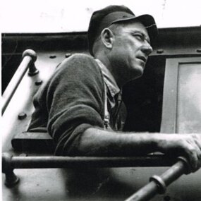
Railway systems have methods by which trains can proceed in safety from station to station, free from the risk of collision with other trains. These methods are generally known as "Safeworking" and they particularly apply to trains on single lines where trains run in opposite directions. The stations between these two sections are called crossing stations. A "Train Staff", a thick, round metal rod, bearing the name of the two stations is issued and these places are designated as Train Staff stations. No train is permitted to proceed through the section unless the train driver either takes the staff for the section into his possession or personally sights the staff. (Note that every station on the line is not a crossing station. These roles were performed at Barongarook, Gellibrand, Banool, Beech Forest, Wyelangta, Weeaproinah and Crowes.) Except for the period 1927-1939 when Train Section Orders were applied instead, due to declining business Train Staff and Ticket working was used throughout on the line.B/W. Driver Bill Brady holding the Train Staff in the cabin of Garratt locomotive G42, at Weeaproinah 1961 railways, bill brady, train driver, weeaproinah, train staff -
 Vision Australia
Photograph - Image, Foto Group, 25th Anniversary of Vision Australia Radio, 15 May 2007
On June 15, 2007 Vision Australia Radio (formerly 3RPH) celebrated its 25th anniversary of broadcasting. Despite earlier broadcasts on community radio stations, a dedicated radio service for people who wanted to listen to in depth information on news and current events as well as serialisation of books had not eventuated. With the support of Commonwealth funding in 1982, stations were permitted to transmit on marine band frequencies in Melbourne, Sydney and Hobart. With the eventual movement of major stations to FM in the 1980s, provision was finally granted for RPH stations to allow them to move to the AM band in metropolitan areas. In the 1990's regional stations were established, later linking to provide the Vision Australia Radio network. Throughout all of these changes, volunteers have supported the radio station in a range of ways, including collating and reading the newspaper articles for broadcast, helping source interviews and program ideas, operating studio equipment as well as presenting programs themselves.38 digital images of the 25th anniversary of VARvision australia, 3rph radio station, vision australia radio, gerard menses, stephen jolley, pam adams, lynne kells, tim evans, roberta ashby, marj west, norm richards, vince september, norm rees, graeme dawson -
 Marysville & District Historical Society
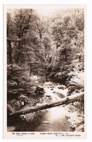
Postcard (item) - Black and white postcard, Rose Stereograph Company, Talbot Drive, Marysville, Vic. No. 3, The Taggerty River, 1913-1967
A postcard in a series produced by the Rose Stereograph Company in Victoria, Australia as a souvenir of Marysville.A black and white photograph taken along Lady Talbot Drive, Marysville, in Victoria, of the Taggerty River. Lady Talbot Drive is a 24 kilometer scenic rainforest car journey which passes a number of walks and waterfalls in the Yarra Ranges National Park. Lady Talbot Drive is named after Lady Sarah Elizabeth, the wife of Sir Reginald Talbot, who was the Governor of Victoria from 25th April, 1904 to 6th July 1908. This postcard was produced by the Rose Stereograph Company as a souvenir of Marysville.POST CARD The "Rose " Series/ De Luxe A Real Photograph/ Produced in Australia Published by the Rose Stereograph Co./ Armadale, Victoria. Dear John,/ I am writing this note in my room/ at Mt. Kitchener House before sallying forth for/ dinner. Unfortunately space does not permit/ me to tell you much, but I must let you know/ that yesterday morning (Monday), a blanket of/ snow covered the township of Marysville to a/ depth of three or four inches. Further up, near/ Keppel's Lookout, which we visited yesterday, it/ was nearly a foot deep everywhere, and it snowed/ the whole time we were walking./ Will tell you all later, your friend, Billtalbot drive, marysville, victoria, taggerty river, p. 2308, rose series postcard, postcard, souvenir, sir reginald talbot, lady sarah elizabeth talbot -
 Eltham District Historical Society Inc
Document - Report, Paul Jerome, Advisory Committee on a Proposed Convenience Centre and an Alternative Shire Proposal - Eltham Gateway Community Precinct Concept Plan - 895 Main Road Eltham, October 1997
On 15 December 1994 the former Shire of Eltham ceased to exist following the Liberal Kennett Government local council amalgamations. A new Nillumbik Shire Council was established with unelected commissioners appointed. That Council sold the former Eltham Shire Council Offices and land at 89S Main Road Eltham to Dallas Price Homes Pty. Ltd. the sale being conditional upon the granting of a planning permit for a petrol station/convenience store, fast food and video outlet. The sale was conditional that if the permit was not granted by 30 August. 1997, the contract could be avoided by either the purchaser or the vendor. The proposed development consisted of a petrol station with undercover fuelling facilities, convenience shopping, a drive through service facility for fast food, an 80 seat cafe, automated banking, a children's play area and retail space. In addition, the proposal included a 200 square metre community facility for Council use, provision of on site carparking over 2 levels for 83 vehicles, and advertising signage. An Advisory Committee consisting of Dimitry Reed and Margaret Pitt was appointed under Section 151 of the Planning and Environment Act 1987 to hear submissions on the proposal to develop the land at 895 Main Road Eltham, the site of the former Eltham Shire Offices. In September 1996, two applications were made by Contour Consultants Australia Pty Ltd on behalf of Dallas Price Homes Ply Ltd, to Nillumbik Shire Council. After extensive notification, the Council received 213 objections and a petition of over 1400 signatures. On October 9, 1996, Nillumbik Shire Council issued Notices of Decision to Grant Permit on Applications number 96/03376 and 96/0377 for the use and development of the land as a convenience Centre consisting of a petrol station, convenience store, cafe/takeaway food premises, a retail facility and a community facility, with associated advertising signs. Objectors to the proposals lodged Planning Appeals number 96/40724 and 96/40812 with the Administrative Appeals Tribunal on November 1, 1996. The grounds of appeal can be summarised as: inappropriate development, insufficient carparking, traffic and access issues, unsatisfactory design, inadequate permit conditions, the proposal being out of character with the area. and being contrary to the purpose and orderly development of the Eltham Town Centre, excessive noise, lack of consultation and unsuitable signage. On November 13, 1996, the Minister for Planning and Local Government directed the Registrar of the Administrative Appeals Tribunal. under Section 41 (1) (a) of the Planning Act 1980, to refer the Appeals to the Governor in Council for determination without a hearing or recommendation by the Tribunal. The Minister for Planning and Local Government called in the Appeals as he considered that they raised major issues of policy relating to the facilitation of development in accordance with the objectives set out in Section 4 of the Planning and Environment Act 1987, and that determination of the Appeals could have a substantial effect on the achievement of these planning objectives. The Minister required the Advisory Committee to consider the planning merits of the proposed use and development, and to address the issues raised in the objections. The Advisory Committee was required to produce a report providing: • The Committee's response to the matters detailed; • Relevant supporting information for the Advisory Committee's recommendation; and • A description of the proceedings conducted by the Advisory Committee and a list of those consulted or heard by the Committee. In March 1997, elections were held in the Shire of Nillumbik and the view of the new Council to this proposal differed from the view held by the earlier Council Hence the Submission made to the Committee by the Shire was against the decision by the Shire of Nillumbik to issue the Notices of Decision to Grant a Permit. The Recommendations of the Advisory Committee were: i. The cafe and take away food premises are as of right uses and are therefore allowable, but that shop and petrol station are unacceptable uses. A community facility is a discretionary use and is acceptable. ii. A development of the type and scale proposed is totally inappropriate for this land and that the Applications number 96/03376 and 96/0377 for the use and development of the land as a convenience Centre consisting of a petrol station, convenience store, café/takeaway food premises, a retail facility and a community facility, with associated advertising signs, be refused. iii. The land should be rezoned for public purposes and should remain in the community's ownership for community use. Following this, the Minister for Planning and Local Government, the Hon. Robert Maclellan, appointed Mr. Paul Jerome as an Advisory Committee under section 151 of the Planning and Environment Act 1987 to consider a Convenience Centre and an alternative proposal by Iha Shire of Nillumbik being the Eltham Gateway Community Precinct Concept Plan for the site of the former Shire of Eltham municipal offices at 895 Main Road, Eltham. In summary, the terms of reference for the Advisory Committee required it to: • consider the merits of the Council proposal • examine the merits of both proposals in terms of net community benefit • address the report of the previous Advisory Committee on the Convenience Centre proposal The Advisory Committee inspected the site and considered all the material before It including submissions made by all parties to the previous Advisory Committee and correspondence received by the Department of Infrastructure both before and after that Committee submltted its report. The Advisory Committee also held discussions with the following people: • Cr. Robert Marshall • Cr. Margaret Jennings • Cr. Lex de Man • Mr. Dallas Howgate of Dallas Price Properties, also Dallas Price Homes • Mr. Barry Rochford, CEO, Shire of Nillumbik • Ms. Yvonne Rust, Planning Officer, Shire of Nillumbik • Mr. Gregory Burgess, Architect of the Eltham Library and of Council’s Community Precinct Concept Plan • Mr. Jim Connor representing Mrs Thelma Barkway of the Eltham Senior Citizens Club Having considered all the material before it, the Committee arrived at two basic conclusions. First, the DPP proposal should be rejected because, on its merits, It does not sufficiently satisfy the requirements of the planning scheme which is a statutory document. The planning scheme requires that, before making a decision on the permit applications for the DPP proposal, a range of matters must be considered. It follows that consideration of these matters should Influence the decision. These matters include local policies relating to character and amenity. In particular, these policies seek • to conserve and enhance the bushland/country atmosphere, artistic heritage and strong sense of community of the Eltham Town Centre by ensuring that the design and height of any new development is sympathetic to existing buildings • to achieve a pleasing physical environment within the Eltham Town Centre by encouraging a high standard of architecture and urban design • to encourage Improvement to pedestrian amenity through such facilities as open and shattered rest areas and meeting places, crossing facilities, pedestrian arcades, pedestrian links to car parks and pedestrian weather protection • to reduce conflict between vehicular traffic and pedestrian flows, and • to encourage pedestrian thoroughfares It is submitted, as set out In the main body of this report, that the DPP proposal fails substantially to meet these policies and In so doing does not merit the exercise of discretion In Its favour with the Issuing of a permit. This finding is not offset by the investment and employment attributes of the proposal. They do not override the need to comply with the planning scheme. Second, the Council proposal, on Its own merits, substantially meets all statutory requirements applicable to this site with a possible reservation about car parking and traffic management which need further definition and assessment as the concept is refined. The Council proposal, however, has a serious weakness in that Its financial viability has not been adequately tested. The Committee refers to 'financial' rather than 'commercial' viability in recognition that Council owns the land and may enter into a range of agreements and partnerships to realise its concept some of which may be truly commercial and some of which may involve an element of subsidy arising from Council's involvement as a public body acting on behalf of its community. The Committee concludes that Council should be given the opportunity, within a reasonable timeframe to establish the financial feasibility of its concept and should develop a strategy for the future of Its land asset at 895 Main Road in the event that Its concept for the site cannot be realised. 895 main road, advisory committee, dallas price homes, eltham, eltham shire office, nillumbik shire council, planning application, administrative appeals tribunal -
 The Beechworth Burke Museum
Photograph, est. 1860-1875
In 1875, the Rocky Mountain Extended Gold Sluicing Company Ltd was created, utilising the previous Rocky Mountain claim for the area near Lake Sambell. The company employed A.L Martin to survey an area for a tunnel underneath Beechworth and Johnson Stephens to dig it. The tunnel was built at a rate of 40 feet a month and eventually measured 800 metres. The tunnel was a true accomplishment both in the present and during the 19th century. It was considered to be a marvelous engineering feat. Beechworth is renowned for its hydraulic sluice method of mining. This involved soil being exposed to torrents of water from high-pressure hoses. From 1876 until its closure in 1921, the mine produced an astounding 47,926 ozs of gold. Companies like this were the source of income for many Chinese gold-diggers who sought to make their fortune on the goldfields of Beechworth. During the height of the rush, the town had around 7,000 Chinese inhabitants living on the outskirts of town as they were not permitted to live within Beechworth itself.The search for gold is ingrained into the history of Victoria and therefore, images like this one which portrays an open-cut sluicing site can reveal important information for society and technology for the date when the photograph was taken. This image is of important historical significance for its ability to convey information about sluicing and the methods used to find gold in 1910. It also shows a location where sluicing was undertaken which provides insight into the impact of sluicing on the environment at a time when it was done. This image of the Rocky Mountain mine is historically significant as the mining complex is now non-existent, with the only remains being the tunnel built in 1880 by the company, which was considered one of the greatest engineering feats of the time. The image also provides a first-hand look into the social and cultural networks at play during the 19th century with racial segregation of the Chinese at the 'Chinese Camp', as well as an insight into Beechworth's origins during the Gold Rush.A sepia rectangular photograph printed on matte photographic paper as a postcardReverse: Historic Beechworth / 7792.1 / ROCKY MOUNTAIN MINE / Viewed from the “Chinese Camp”, shown partly in the foreground, we see the central plant of the famous Rocky Mountain Mining Company. This extensive complex, of which nothing remains, was situated between Silver Creek and the present Lake Sambell area. The company was responsible for a tunnel cut through solid bedrock underneath the town of Beechworth and surfacing near the keystone bridge on the Wangaratta side. Completed in 1880 it was declared to be one of the greatest engineering feats in Australia. The tunnel is still basically intact today. / Series by Wooragee Graphics: Historic Beechworth. / COPYRIGHT BURKE MUSEUM / No.72 beechworth, rocky mountain mine, sluicing, gold rush, mining, gold -
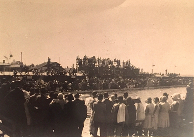 Kew Historical Society Inc
Photograph, Kew Municipal Baths, 1929-1933
W.D. Vaughan in 'Kew's Civic Century' (1960) has a chapter (XXII, pp.103-105) on the Kew Swimming Pool (aka Kew Baths). In the chapter he recounts debate in Council from 1912 about the need for a swimming pool. The first concrete step toward achieving this occurred in 1914 when Council purchased the Tramways Sheds on the corner of High and Disraeli Streets in 1914. Further adjoining land in High Street was compulsorily acquired in 1923. The final plans were accepted in 1925 and following public tender, Messrs. Weavill and Keast were appointed to construct the pool at a cost of 5,418/9/-. The baths were formally opened on 18 November 1925 by George Ramsay, Mayor of Kew. (The Kew Swimming Club was founded in the same year.) Vaughan notes that "mixed bathing was not permitted at the Kew Baths until January, 1928, when it was allowed every evening (except Sundays) and Friday afternoons. A few years later these restrictions were removed altogether".Small B&W photograph of a crowd of onlookers watching swimming events in the old Kew Swimming Pool in High Street. The photograph can be dated to the years 1929-33, as the wooden grandstand was not erected until 1929 and it was before a new high swimming platform was erected in 1933."Old Swimming Pool. D1. 92"kew swimming pool - kew (vic), sport and recreation - kew (vic), kew baths - kew (vic), mayors of kew - cr. george ramsay - kew (vic), kew swimming club -
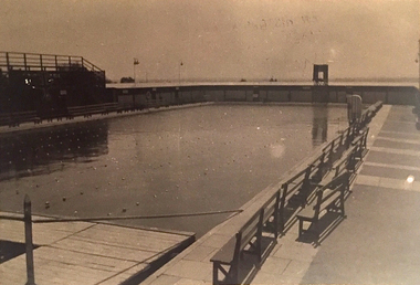 Kew Historical Society Inc
Photograph, Kew Municipal Baths, 1929-1933
W.D. Vaughan in 'Kew's Civic Century' (1960) has a chapter (XXII, pp.103-105) on the Kew Swimming Pool (aka Kew Baths). In the chapter he recounts debate in Council from 1912 about the need for a swimming pool. The first concrete step toward achieving this occurred in 1914 when Council purchased the Tramways Sheds on the corner of High and Disraeli Streets in 1914. Further adjoining land in High Street was compulsorily acquired in 1923. The final plans were accepted in 1925 and following public tender, Messrs. Weavill and Keast were appointed to construct the pool at a cost of 5,418/9/-. The baths were formally opened on 18 November 1925 by George Ramsay, Mayor of Kew. (The Kew Swimming Club was founded in the same year.) Vaughan notes that "mixed bathing was not permitted at the Kew Baths until January, 1928, when it was allowed every evening (except Sundays) and Friday afternoons. A few years later these restrictions were removed altogether".Small B&W photograph of the old Kew Swimming Pool showing seating at right. The photograph can be dated to the years 1929-33, as the wooden grandstand was not erected until 1929 and it was before a new high swimming platform was erected in 1933."D3. 92"kew swimming pool - kew (vic), sport and recreation - kew (vic), kew baths - kew (vic), mayors of kew - cr. george ramsay - kew (vic), kew swimming club -
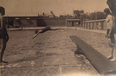 Kew Historical Society Inc
Photograph, Kew Municipal Baths, 1930s
W.D. Vaughan in 'Kew's Civic Century' (1960) has a chapter (XXII, pp.103-105) on the Kew Swimming Pool (aka Kew Baths). In the chapter he recounts debate in Council from 1912 about the need for a swimming pool. The first concrete step toward achieving this occurred in 1914 when Council purchased the Tramways Sheds on the corner of High and Disraeli Streets in 1914. Further adjoining land in High Street was compulsorily acquired in 1923. The final plans were accepted in 1925 and following public tender, Messrs. Weavill and Keast were appointed to construct the pool at a cost of 5,418/9/-. The baths were formally opened on 18 November 1925 by George Ramsay, Mayor of Kew. (The Kew Swimming Club was founded in the same year.) Vaughan notes that "mixed bathing was not permitted at the Kew Baths until January, 1928, when it was allowed every evening (except Sundays) and Friday afternoons. A few years later these restrictions were removed altogether".Small B&W photograph of two boys standing beside a diving board at the old Kew Swimming Pool while in the distance a woman dives into the pool. The photograph can be dated to the years 1929-33, as the wooden grandstand was not erected until 1929 and it was before a new high swimming platform was erected in 1933."Old Swimming Pool Kew. D4. 92"kew swimming pool - kew (vic), sport and recreation - kew (vic), kew baths - kew (vic), mayors of kew - cr. george ramsay - kew (vic), kew swimming club