Showing 2028 items matching "planning document"
-
 Warrnambool and District Historical Society Inc.
Document, Register Subdivision WCC, Late 20th century
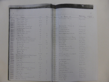
These sheets contain photocopied information on Warrnambool streets and blocks – Allotment numbers and Section numbers, names of developers, date of street construction approval, names of lawyers, Titles Office information etc. They have been originally compiled by Warrnambool City Council staff and concern Warrnambool streets projects from the 1950s, 60s and 70s. This is photocopied material and therefore is of little historical importance. But the information contained therein will be useful for researchers. Document One: These are 57 photocopied pages containing lists of Warrnambool streets and blocks and information on their development. The original information has been handwritten. The pages have been stapled together but the staples have been removed. Document Two: These are twelve photocopied lists of Warrnambool streets with sub-division and development information. The lists have printed plan numbers on the left side and the rest of the information is hand-printed. Two pages have been glued together on one sheet to make six pages. The pages have been stapled together but the staples have been removed. warrnambool streets, warrnambool city council, history of warrnambool -
 Warrnambool and District Historical Society Inc.
Document, Steam Cylinder Horizontal Engin, 1919
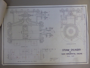
This drawing was produced by Ron Uebergang in 1919 at the Warrnambool Technical School. Members of the Uebergang families have been in the Warrnambool/Allansford area since the early 1850s. Ronald Uebergang (1903-1971) was born in Warrnambool, the son of Ernest Uebergang and Mary Watson. He lived at the family property, Hopkins Hill, and went to Allansford State School and Warrnambool Technical School. He was mechanically-minded, fond of music and dancing and a keen photographer. He married Myra Hall and they ran a dairy farm at Hopkins Hill and later went in for grazing beef cattle. Warrnambool Technical School was established in 1913, firstly at a Timor Street site and later at Caramut Road. Today it is called Brauer College. This drawing is of considerable interest as it was produced by Ron Uebergang. Members of the Uebergang families have been prominent in the Warrnambool/Allansford area since the early days of the district’s establishment. It is also important as a good example of the type of work produced by students from Warrnambool Technical School in its early years. This is a1919 drawing of a Steam Cylinder for a 45 HP Horizontal Engine. The drawing is half the full size of the cylinder. The drawing is on a white card with the sketches done in black and red ink. The card has a heavy black margin around the edges drawn in black ink. The drawing shows a Sectional Plan and a Half Side Elevation with the Cover Plate Removed. The card has the signature of Ron Uebergang. Attached by a metal clip to the card are four pages of measurements and plans of the steam cylinder. These are in black and red ink. Three of these pages have become partly detached. ‘Designed by R. Uebergang’ ‘Drawn by R. Uebergang’ ‘Date 1/12/19’ ronald uebergang, warrnambool technical school, history of allansford, history of warrnambool -
 Warrnambool and District Historical Society Inc.
Document, Drawing of church of Christ Warrnambool, Mid 20th century
These are plans for proposed additions to the Church of Christ in Warrnambool. The date of the drawings and the maker of the plans are unknown. The additions do not appear to have been built. The Church of Christ in Warrnambool was founded in 1875 after a meeting at the Warrnambool Temperance Hall. The building in Spence Street Warrnambool was erected in 1884 at a cost of £1600 and officially opened in 1885. This church was sold and in 2000 the congregation moved to a new building at 186 Raglan Parade (called Gateway Church of Christ).These plans are of some interest as being part of the history of a Warrnambool church – the Church of Christ Warrnambool. These are two rough drawings on cream-coloured paper showing proposed additions to the Church of Christ in Warrnambool. The drawings are in pencil and include the front elevation plan and the first floor plan. The captions are in capital letters. Both pages have tattered edges and are torn across the middle and the pages are stained in places.‘Rough drawing suggested additions for Church of Christ Warrnambool’ ‘Suggested additions for Church of Christ Warrnambool’ church of christ warrnambool, gateway church of christ, history of warrnambool -
 Warrnambool and District Historical Society Inc.
Book, Description & plans of title & grants
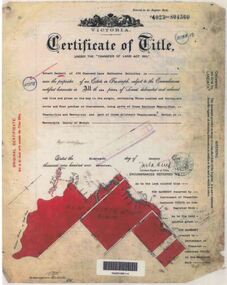
This book contains certificates of title and Crown grants which record local changes of ownership.many are in the township of Warrnambool while others relate to areas such as Nullawarre, Purnim and Framlingham. These documents come under the Transfer of lands act of 1890.The significance of this book lies in the many names and the land to which they were connected. Deep maroon paper over card cover with dark green fabric binding.Alphabetical index at the front followed by 200 pages which record details of the Certificates of title and Crown Grants from around the period of warrnambool, warrnambool history, certificate of title, crown grant warrnambool -
 Warrnambool and District Historical Society Inc.
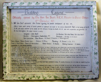
Document - Aquarium Information sheet, Circa 1971
The information on this document shows the inspiration and planning for the building of the aquarium at the Warrnambool breakwater. The instigator was Mr. John Doull, builders Fotheringham Constructions and architects, B. Auty and D Jenner. The Aquarium was opened in December 1971 by The Hon Ian Smith MLA. There were four separate exhibitions and galleries listed on the document. The Aquarium closed around 1998.A local landmark in the latter part of the 20th century with the domes being easily recognized. The people involved in its construction were an important part of Warrnambool’s history.Framed document in green and white speckled wooden frame. Hand written in black on white paper. Subline is written in red.warrnambool history, warrnambool aquarium, john doull, fotheringham constructions -
 Eltham District Historical Society Inc
Document, 14 Stokes Place, Eltham: Building plans and contracts, 1979c
... : Building plans and contracts Document ...14 Stokes Place was the home of Peter and Carla Vermey. The land was purchased in May 1979 and the home built by Peter and Carla Vermey after the developer, Macquarie Builders went bankrupt. Sold October 2017 by Morrison and Kleeman Real Estate. Stokes Place was part of the Stokes Orchard Estate which was developed from the break-up of the the orchard owned by Frank Stokes who lived on the northeast corner of Nyora Road and Eucalyptus Road. His daughter Beryl advised that the Shire had levied a rate assessment on individual parcels of land within the orchard which became unaffordable resulting in its sub-division and sell off. The Stokes Orchard Estate was developed by Macquarie Builders in two stages starting with stage 1 in 1976. Stokes Place was part of Stage 2 in 1979. The Estate was bounded between Nyora Road, Eucalyptus Road, Diosma Road and Stokes Place. The original orchard only just reached the left most portions of Stokes Place and did not go fully up to Diosma, rather to just beyond the extant of Stokes Place. Stokes Place was known within the family as "The Oats" as that is where they grew oats. Frank Stokes moved to Eltham c.1945 after visiting Harold Bird to view his orchard, located diagonally opposite Stokes Orchard from the intersection of Eucalyptus Road, Pitt Street and Nyora Road. It was on Harold Bird's recommendation that Frank purchased the land.The Stokes Orchard Estate collection is typical of housing developments of the late 1970s and 1980s. It was one of the earliest estates in Eltham following the nearby Woodridge Estate development.Digital file30 digital files scanned from documents provided on loan by Peter and Carla Vermeystokes place, eltham, stokes orchard, stokes orchard estate, streets, houses, peter and carla vermey -
 Eltham District Historical Society Inc
Document, Objection by P. and C. Vermey to Application Ref. No. E94/306 - proposed subdivision Melbourne Water Reservoir & Pumping Station - Diosma Road, Eltham, 1 September 1994, 1/9/1994
The Stokes Orchard Estate collection is typical of housing developments of the late 1970s and 1980s. It was one of the earliest estates in Eltham following the nearby Woodridge Estate development.A4 letter and five accompanying supporting pagesAs notedstokes place, eltham, stokes orchard, stokes orchard estate, streets, houses, peter and carla vermey, diosma road, letter of objection, melbourne metropolitan board of works, planning application, reservoir, shire of eltham -
 Eltham District Historical Society Inc
Document, Notice of Decision to Grant a Permit; Ref: E94/306 - Subdivision of 30-34 Diosma Road; 16 November 1994, 16/11/1994
This permit was eventually overturned following community objection and the land was donated by Yarra Valley Water for use as a community reserve.The Stokes Orchard Estate collection is typical of housing developments of the late 1970s and 1980s. It was one of the earliest estates in Eltham following the nearby Woodridge Estate development.A4 document consisting of ten pagesAs notedstokes place, eltham, stokes orchard, stokes orchard estate, streets, houses, peter and carla vermey, diosma road, letter of objection, melbourne metropolitan board of works, planning application, reservoir, shire of eltham -
 Eltham District Historical Society Inc
Document, Advertised Development Plan 424/2017/03P for 28 Luck Street, Eltham by R.P. Home Developments Pty Ltd, 29 January 2018
Former Eltham Specialist Centre Nillumbik Shire Council Advertised Application; 9 of 10 pages sourced from Eltham Community Action Group Facebook page, 21 March 2018 Buildings and works to construct (6) six dwellings and reduction of car parking requirements by not providing one visitor car space Digital image (9)eltham, eltham specialist centre, luck street, bible street, r.p. home developments pty ltd, streets -
 Orbost & District Historical Society
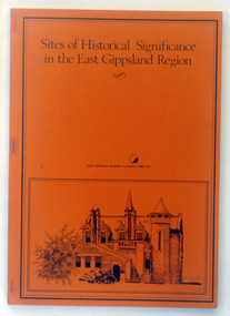
Booklet - book, Booklet, softcover, Sites of Historical Significance in the East Gippsland Region, October 1980
This is the second report by the East Gippsland Regional Planning Committees part of the Regional Studied Program in East Gippsland requested by Mrs Marion Le Cheminant.This is a useful reference tool. It documents sites of significance, including the Orbost area of East Gippsland.A stapled book with a brown/orange cover. On the front cover is a black print hand-drawn illustration of some buildings (possibly Bairnsdale Courthouse. The title, "Sites of Historical Significance in the East Gippsland Region", is in black print at the top. This is inside a black border.Sites of Historical Significance / in the East Gippsland Region / EAST GISPPSLAND REGIONAL PLANNING COMMITTEEhistoric sites, history, east gippsland, heritage -
 Orbost & District Historical Society
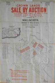
maps, early 1900s
796.1 - Crown Land Sale by auction in the township of Mallacoota on Wednesday January 1920 at 2pm. 796.2 - Snowy River farms , 630 acres of river flat land at Orbost on Wednesday April 28, 1909 at 2.30pm. 796.3 - Famous Orbost Flats - "Important Sale of Snowy River Land" , 900 acres subdivided into 13 choice farms on Wednesday 1st December 1920 at 2.30pm. 796.4 - "Second Great Sale in James' Subdivision", adjoining town of Orbost on 16th May, 1919 at 2pm. 796.5 - "Subdivisional Sale Brooklands Estate", 5 rich Snowy River farms on Wednesday 23rd February at 2.30 at Orbost on account of James Hossack Esq. 796.6 - "Subdivisional sale of Splendid Residence Sites and Handy Small Paddocks" adjoining the progressive town of Orbost on 5th March 1915 at 11am at the rooms of H.James & Co. 796.7 - This is a contract drawing on waxed paper. Crossing near Harbecks Cunninghame Signed and traced N. Anderson 17/11/00. 796.8 - A plan and specification on waxed paper. Shire of Orbost Cunninghame Road - signed by the shire engineer. 796.9 - This is a hand drawn map of Orbost Cunninghame Road, November 1896. 796.10 - This is a hand drawn cross-section of a culvert on the Orbost Cunninghame Road. 796.11 - This is a plan of a culvert on Tabbara Road, 13th January 1899 796.12 - This is a poster for an "Important Subdivisional Sale' for land near Orbost Bridge, on Wednesday 16th March 1921 at the rooms of H. James & Co. These documents are an important part of Orbost history in that they show how the town and surrounding areas were subdivided for farming and residential settlement.A set of twelve maps, plans and land sale posters .orbost-land-1900s maps posters h.james -
 Ringwood and District Historical Society
Documents, 1997 Bushland Management Plans for BJ Hubbard Reserve, Wombolano Park, Loughie's Bushland, and weed control monitoring sheet
Five Bushland Management Documents 1. Bushland Reserve Management Plan 2. Weed Control Monitoring Sheet 3. BJ Hubbard Reserve - Bushland Management Plan 1997 4. Wombolano Park - Bushland Management Plan 1997 5. Loughie's Bushland Management Plan 1997 -
 Ringwood and District Historical Society
Document, Packet: Ringwood Youth and Youth Club - Annual Reports 1962-3. Correspondence and Clippings 1971-1989, 1962-1963
Packet- Miscellaneous documents relating to Ringwood Youth and Youth Club.Packet includes: . Correspondence- Ringwood Youth Activities Committee, 1971. Newspaper cuttings from 1954 to 1991 to do with Ringwood youth activities. . Brochure- Empire Youth Sunday Dedication Service, 21say, 1950. . Invitation from Ringwood Police & Citizens Youth Club to Mr & Mrs Pullin, to the opening of Clubrooms at Bedford Park 22nd August, 1959. . Ringwood Police & Citizens Youth Club Annual Reports, 1962 and 1963. . Hand written notes for the catering details for the Youth Club Ball, October 1956. . Booklet- 'Meeting The Needs Of Youth In Ringwood'. Report prepared by the Youth Services Planning Division, Victorian Association of Youth Clubs for the Ringwood Youth Action Committee, March 1971. -
Ringwood and District Historical Society
File, Ringwood Library Promotion Committee documents and Library Notes and Clippings; Meeting Reports 1965-1972, 1965-1972
Ringwood Library Promotion Committee; 1. Library Notes from Ben Hubbard.; 2. Newspaper cuttings re library planning.; 3. G.R. Enting Correspondence.; 4. Meeting Reports 1965-1966.; 5. Minutes and Correspondence.; 6. Brochure.; 7. Book of newspaper cuttings.; 8. Receipt book. +Additional Keywords: Hubbard, Ben -
Ringwood and District Historical Society
Envelope, Jean Gordon Government Printer - Melbourne, Ringwood Primary School: Documents re Proposed school rooms, Canteen and Library plans, electrical plans. 1969-1973, 1969-1973
... School Documents:; 1969 Proposed school rooms - Plans.; No Date ...School PlansRingwood Primary School Documents:; 1969 Proposed school rooms - Plans.; No Date - Canteen Plans.; 1973 Library - Plans.; No Date - Electrical Plans. +Additional Keywords: Gordon, Jean -
 Ringwood and District Historical Society
Document, Packet: Ringwood Chamber of Commerce & Whitehorse Traders - Early correspondence (1930's) and Clippings etc. 1950s-1990s
Miscellaneous documents relating to the Ringwood Chamber of Commerce and Whitehorse Traders.Packet includes: . Correspondence to Council re Ringwood Xmas Carnivals in the 1930's. . Hand written minutes of meetings of Ringwood Traders- c1930's. . Miiscellaneous newspaper clippings relating to Ringwood Traders- 1909 to 1990's. . Plan of proposed 'Fat Boiling Down Room' for Mr G. Pratt, butcher in Junction Rd Ringwood. c1937. . Description and rough sketch of proposed building for "My Ease (Vict.) Pty. Ltd." as factory for Manufacturing Worcestershire Sauce. c1929. . Price list for H. J. Bently, Timber Merchant, Ringwood, dated June 1917. . Literature compiled by the Ringwood Chamber of Commerce advertising Ringwood as a business centre. -
Ringwood and District Historical Society
Document, Packet: Ringwood Early Planning Retirement Association early history; office bearers 1970s
5 typed pagesPages include: . Office bearers and Committee of Ringwood E.P.R.G. Inc. from 1976-77 to 1995-96. . History of Ringwood E.P.R.G. -
 Ringwood and District Historical Society
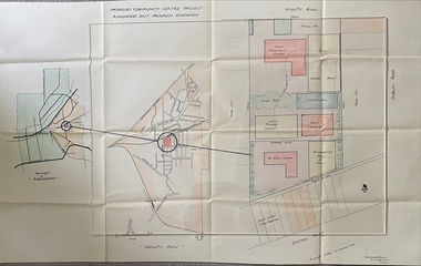
Document, Packet: East Ringwood Community Centre
Packet includes: East Ringwood proposed plan for Community Centre June 1950. (3838b) Pamphlet about proposed Centre. Programme for Official Opening of Clubrooms, August 1968. Newspaper clipping re completion of Clubrooms. -
Ringwood and District Historical Society
Document, Packet: Five Ringwood Movie Club booklets with several newspaper clippings re cinema 1990s
Packet includes: . 5 copies of Ringwood Movie Club newsletter titled "Take One" dated 1979 onwards. . Several newspaper cuttings from the 1990's re plans for a cinema complex in Eastland, and the dispute between the proposal by Ringwood Multiplex Cinemas' development at the Ringwood Market site in Bond Street. -
 Ringwood and District Historical Society
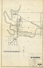
Document, Packet: Ringwood Rifle Club schedules, receipts, events. Mostly 1950s and 60s
Rifle Club schedules, receipts and eventsPacket includes: . 4009a- Collection of fixtures, receipts, newspaper clippings, miscellaneous Club notes, results and meeting reports. . 4009b- Letter dated 14th February 1960 written by Ron Pullin of the Ringwood Historical Research Group detailing the history of the formation of Ringwood Rifle Club in 1954. . 4009c- Plan of site of Ringwood rifle range dated 22.10.1954. . 4009d- Honorary Life Membership Certificate presented to James Mitchell,esq, dated December 1961. . 4009e- Certificate presented to Ron Pullin for services as Treasurer 1957-63. . 4009f- Invitation to the Official Opening of the Ringwood Rifle Range on 12 September 1959. . 4009g- Invitation to Ron Pullin to 20th Anniversary 'Invitation Match' on 23rd March, 1974. . 4009h- Receipt dated 3.10.1960 from Victorian Rifle Association for £57.10.0 for ammunition. -
 Orbost & District Historical Society
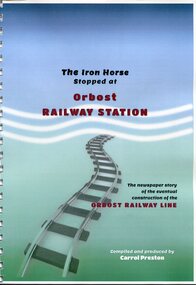
Book, The Iron Horse Stopped at Orbost Railway Station, 2019
Carrol Preston has used newspaper references from 1877 through to 1917, to document the history of the Orbost - Bairnsdael railway line.. It starts with the lobbying and jockeying, and moves through to the opening in 1916. The title is a reference to plans to further extend the railway beyond Orbost - but "The Iron Horse stopped at Orbost Railway Station". Most articles are from the Snowy River Mail and Bairnsdale Advertiser. All newspaper articles are dated and sourced. About 1912 work began at Newmerella on clearing the track for the railway line from Bairnsdale to Orbost. A canvas town sprang up on the higher land adjacent to the river flats. Local farmers supplied meat, milk and fresh produce to the camp, as well as gaining employment carting and labouring. The line opened in 1916, the Orbost railway station being built on the Newmerella side of the river.This item is associated with the history of the Orbost-Bairnsdale railway line and therefore reflects the role that the rail line played in the social and economic history of Orbost. On April 10 1916, the first scheduled train service left Orbost for Bairnsdale. The Bairnsdale-Orbost railway was opened to serve the agricultural and timber industries. This book has been compiled by a local historian. A spiral bound book titled, "The Iron Horse Stopped at Orbost Railway Station". The cover is blue / green with the title in black and red print. Underneath is a railway track leading to the bottom of the page. The book is 110 pages, A4 size and contains maps and photos. in black print on cover - "The Iron Horse Stopped at Orbost Railway Station ; The newspaper story of the eventual construction of the ORBOST RAILWAY LINE (in red print); Compiled and produced by CARROL PRESTON (in white print)railway-transport orbost-bairnsdale-railway east-gippsland-railway -
Ringwood and District Historical Society
Legal record - Conditions of Sale (C.E. Carter), Ringwood Electric Railway Estate, Lots 98 and 99, Sale to Tilbury and Albon, 1925
Original Particulars and Conditions of Sale document by C.E. Carter & F. H. Patterson & Co, to B.C. Tilbury Esq and A.J.Albon Esq: Lots 98 and 99, Electric Railway estate, Ringwood Plan of Subdivision 9473, Crown Portion 18, Parish of Ringwood. -
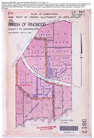 Ringwood and District Historical Society
Document, Sale of Land Act documents - Part of Crown Allotments 14A, 40A, 40B & 4C, Parish of Ringwood - 1895
Certificate of Title - Georgina Elizabeth Wingfield Knox, wife of William Robert Knox, part of allotments 14A and 40A, 27th November, 1895, and subsequent transfers up to 1959. Plan of Subdivision includes Allens Road, The Greenway, Dickasons Road, and Canterbury Road, Ringwood. (With further residential and commercial developments taking place since the 1920s, this area became part of the suburb of Heathmont.) -
 Ringwood and District Historical Society
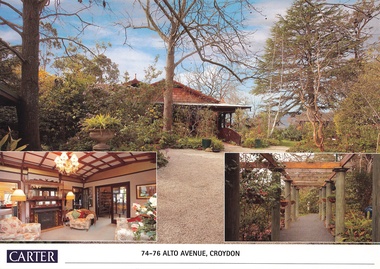
Document, Real Estate History of "Shadowood", 74-76 Alto Avenue, Croydon, Victoria
Folder of Estate Agent's notes compiled in preparation for property auction, 11th October, 2008. Two-page history of "Shadowood", display photo of house with floor plan dating from circa 1920s, copies of LANDATA title documents. Map of Wicklow Hills subdivision, including Alto Avenue, Elesmere Avenue, Glenora Avenue, Wicklow Avenue, and railway line to Lilydale. Title Vol 1323 Fol 264412 Allotment 43C Parish of Warrandyte - Ann McKean, dated 6th October, 1881. Title Vol 1937 Fol 387367 Part of Allotment 43C Parish of Warrandyte - Richard Bonynge Kelly, 11th August, 1887. Title Vol 2728 Fol 543569 Part of Allotment 43C Parish of Warrandyte - Thomas Robertson, 27th July, 1898. Title Vol 4161 Fol 832181 Part of Allotment 43C Parish of Warrandyte - John Gordon Robertson, 4th November, 1918. Title Vol 4490 Fol 897808 Lots 82 and 83, Plan of Subdivision 7478 - Elizabeth Rutherford Morell, 12th August, 1921. Title Vol 4617 Fol 923322 Lot 82, Plan of Subdivision 7478 - Flora Clapperton, 23rd September, 1922. Title Vol 8409 Fol 533, part of Lot 82, Plan of Subdivision 7478 - Hugh Ravenscroft Hastings Wettenhall and Sybella Anne Wettenhall, 1st May, 1962. -
 Ringwood and District Historical Society
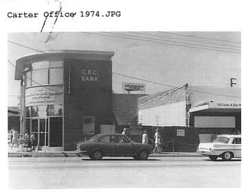
Document, Certificate of Title and miscellaneous property records - Carter Real Estate, 122 and 124-128 Maroondah Highway, Ringwood, Victoria
Transfer of Land Act Title dated 24/4/2002 - Volume 10314 Folio 972 Crown Allotments 11H and 11J, Parish of Ringwood, Entitlement Grant to a depth of fifteen metres - 29/1/1997, City of Ringwood planning permit and diagram of office floor plan - 1973. -
 Ringwood and District Historical Society
Document - Research Folder, Helm Family, Oban Road, Ringwood, Victoria - 1917-2008
Transcription of conversation with Alma and Kelly Helm by Richard Carter (Past President of Ringwood Historical Society) and Larraine Haslam on 18 July 2008 detailing family history. Certificates of title of land between Oban Road and Mullum Mullum Creek. Six and a half acres sold to the Helm Family in 1917. Includes Certificate of Title Vol 5311 Fol 1062052 Carolyn Mary Glynn dated 27 April 1927. Certificate of Title Vol 4023 Fol 804560 Robert Beckett dated 19th January 1917. Plans of Subdivision including Oban Road, Barnsdale Way, Loughies Track, 1997. Certificate of Title Vol 4029 Fol 805702 Ellen Elizabeth Helm dated 8th February 1917. Transfer of Land (2093031) payment to James William Dartnell by Alma Mary Helm and Elsie May Helm of Oban Road, Ringwood North - 13th August, 1947. -
Ringwood and District Historical Society
Document - Report, Joy Czarnecki, Ringwood Technical School Report on Planning Effective Inservice Education by Joy Czarnecki Oct 22 1984, 22/10/1984
Black and White Documentrts, ringwood tech -
 Orbost & District Historical Society
plan, before 1948
Drainage infrastructure was developed and maintained in this region by the Snowy River Improvement Trust. The Trust was administered by a local committee and its activities funded by a local rate charged on the farmers and land owners in the Trust’s designated district. The level of the rate charged by the Trust was designed to be proportionate to the benefit derived from the works undertaken. Financial assistance was provided by the State Government from time to time for specific projects such as post flood repairs but not for new capital works. The Trust undertook new drainage and river management works including tree planting, rock beach construction and servicing of the drains and flood gates. The Trust also provided a personal flood warning service to the farmers in its district. The Trust ceased to operate in 1997 with the advent of the East Gippsland Catchment Management Authority. The infrastructure developed by the Trust continues to provide a service to the farmers in the region. (ref. 4 East Gippsland CMA Submission to Inquiry into Flood Mitigation Infrastructure in Victoria) This plan is significant as a historical document. The Snowy River Improvement Trust was vital to the Orbost district because of its ability to apply local knowledge and to engage the local farming community.A large plan of divisions of land for the purpose of levying the Snowy River Improvement District - Bete Bolong, Orbost, Waygara, Newmerella and Orbost East. The properties are coloured according to levy amount. The scale is 1" - 20 chains. snowy-river-improvement-trust -
 Orbost & District Historical Society
folder, Orbost Bridges - Snowy River Road Bridges, 1974 1976
This folder was compiled in October 2015 from documents, magazines. papers and photographs donated by David Jellie, engineer in charge 1974 - 1976. In early 1974, as an Engineer with the Country Roads Board, David came to Orbost as the Supervising Engineer for the construction of the new bridges which were part of an 8.4km Orbost bypass road design. This was a major project involving not only a new bridge over the Snowy River (including Lochiel Lagoon), but other bridges over Ashby’s Gulch and Watt’s Gulch. These new bridges were opened in November 1976 with the unveiling of a plaque on the eastern end of the $2.4M Snowy River Bridge. (ref. May Leatch)This item is a useful reference tool on the construction history of the Snowy River Road bridges.A white plastic folder - Orbost Bridges - Snowy River Road Bridges. it contains newspaper articles, booklets, photographs and documents relating to the construction of the Snowy River Road Bridge in 1974 -1976.on front cover - 1974 - 76 ORBOST / SNOWY RIVER ROAD BRIDGES * construction * photos * articles * plans Donated by David Jellie Oct 2015snowy-river-bridges jellie-david -
 Federation University Historical Collection
Document - Document - Newsletter, VIOSH: Ballarat College of Advanced Education; Association of Occupational Hazard Management Graduates Newsletter, June 1992
Victorian Institute of Occupational Safety and Health (VIOSH) Australia is the Asia-Pacific centre for teaching and research in occupational health and safety (OHS) and is known as one of Australia's leaders on the field. VIOSH has a global reputation for its innovative approach within the field of OHS management. VIOSH had its first intake of students in 1979. At that time the Institution was known as the Ballarat College of Advanced Education. In 1990 it became known as Ballarat University College, then in 1994 as University of Ballarat. It was 2014 that it became Federation University. VIOSH Australia students are safety managers, senior advisors and experienced OHS professionals. They come from all over Australia and industry. Students are taught active research and enquiry; rather than textbook learning and a one-size fits all approach. VIOSH accepts people into the Graduate Diploma of Occupational Hazard Management who have no undergraduate degree - on the basis of extensive work experience and knowledge. Newsletter of Ballarat University College Association of Occupational Hazard Management Graduates, June 1992. Editor is Thomas Mitchell, who became a lecturer within VIOSH. Newsletter mentions the E C Wigglesworth Award which is given yearly for the best original contribution of a journal article or equivalent published work. Dennis Else's professorial status, Steve Cowley becoming Director of VIOSH, and Derek Woolley taking up the position of Assistant Director of the College. Dulcie Brooke is awarded an honorarium for her many years of involvement with VIOSH. S.H.A.R.E. program enters a new phase. This was an important feature - sharing solutions to problems by establishing a data base. Leaflet advertising a seminar - "Emergency and Counter Disaster Planning" - 23 July 1992. Speakers are Mr Merrick Chatfield - Natural Disaster Organisation, Australian Counter Disaster College, Mt Macedon, Victoria and Dr Norman Barling, Psychology Department, Ballarat University College.A3 sheet folded in half - four pages with two column each. Separate A4 sheet Seminar ProgramLetterhead - Ballarat University Collegeviosh, victorian institute of occupational safety and health, association of occupational hazard management graduates newsletter, thomas mitchell, editor, e c wigglesworth award, dennis else, dulcie brooke, honorarium, s.h.a.r.e., photographs and memorabilia, emergency and counter disaster planning, merrick chatfield, natural disaster organisation, australian counter disaster college, mt macedon, norman barling, psychologist, ballarat university college