Showing 2299 items matching "railway line"
-
 Whitehorse Historical Society Inc.
Photograph, Railways
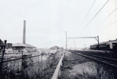
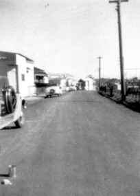
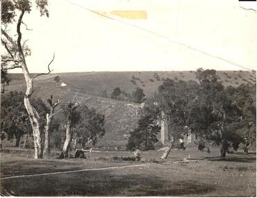
... Early photograph of a railway line heading West towards.... Early photograph of a railway line heading West towards the city ...Early photograph of a railway line heading West towards the city. Australian Tesselated Tile building on the background.railways, australian tesselated tile co. pty. ltd. -
 University of Melbourne, Burnley Campus Archives
Plan, Egg Laying Competition
... , vehicle park, tennis court and railway line.... by potting sheds, vehicle park, tennis court and railway line. Egg ...Copy of plan for fencing. Area bounded by potting sheds, vehicle park, tennis court and railway line.fencing, tennis court, vehicle park, egg laying, competition -
 Maldon Vintage Machinery Museum Inc
Book, The Friends of Mount Alexander Diggings, The Iron Road to Castlemaine and Sandhurst
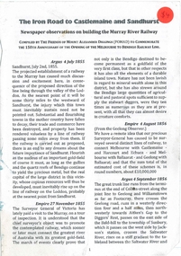
... to Bendigo Railway Line... to Bendigo Railway Line Newspaper observations on building the Murray ...Newspaper observations on building the Murray River RailwayCompiled by the Friends of Mount Alexander Diggings (FOMAD) to Commemorate the 150th Anniversary of the Opening of the Melbourne to Bendigo Railway Line -
 Ringwood and District Historical Society
Drawing - Hand-drawn map, Part of Crown Allotment 22, Ringwood East, Victoria (Undated)
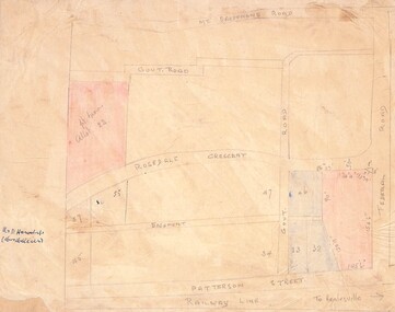
... (Railway line to Healesville marked on the map indicates...(Railway line to Healesville marked on the map indicates ...Pencil drawing on light cardboard backing. Colour-shaded residential allotments on Rosedale Crescent, Patterson Street and Federal Road, Ringwood East.(Railway line to Healesville marked on the map indicates creation date precedes closure of line beyond Lilydale in 1980) -
 Bendigo Historical Society Inc.
Photograph - PHOTOGRAPH. ELMORE SILOS, 1993
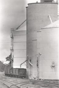
... Photograph. Elmore silos next to railway line. Six railway... to railway line. Six railway trucks positioned ready to be filled ...Photograph. Elmore silos next to railway line. Six railway trucks positioned ready to be filled. Man walking between lines toward silos and trucks.elmore, silos, agricultural -
 Wodonga & District Historical Society Inc
Functional object - Rail fish plate from Cudgewa Line, 1930 - 1960s
... Cudgewa Line -The Cudgewa railway line opened in stages... Cudgewa Line -The Cudgewa railway line opened in stages between ...Cudgewa Line -The Cudgewa railway line opened in stages between 1889 and 1921. The first section from Wodonga to Huon opened on 10 September 1889. It was extended to Bolga on 18 July 1890, Tallangatta on 24 July 1891, Shelley on 13 June 1916 (the highest station in Victoria), Beetomba on 10 April 1919 and Cudgewa on 5 May 1921. The line had 1 in 30 grades and trestle bridges that have been heritage listed. In 1919, the line was used to carry materials for the construction of Hume Weir, and three years later a spur line connecting Ebden to the weir was opened. In the 1960s, Cudgewa became the railhead of materials for the Snowy Mountains Scheme. The last passenger service from Wodonga to Tallangatta ran on 30 September 1961. The turntable and passenger platform at Cudgewa were abolished in 1976. This fish plate came from the rails of the Cudgewa Line at Gordon Roy's hut which was situated behind Perry's Stump Hotel outside Wodonga. The hut was used as an office with the points lever outside to switch trucks to different tracks on the Bandiana and Cudgewa lines.This item is significant as it was part of the railway line to Cudgewa which played an important role in North east Victoria carrying freight during the construction of the Hume Weir and the Snowy Mountains Scheme.A section of flat plate. These plates were used in pairs to connect the ends of adjacent rails in railway track. victorian railways, cudgewa rail line, railway components -
Tatura Irrigation & Wartime Camps Museum
Photograph, Mr and Mrs Frank Williams
... Tatura, between Railway Line and Thomson Street.... Williams of Williams Store, Hogan Street Tatura, between Railway ...Mr & Mrs Frank Williams of Williams Store, Hogan Street Tatura, between Railway Line and Thomson Street.tatura, buildings, historic -
 Ballarat Heritage Services
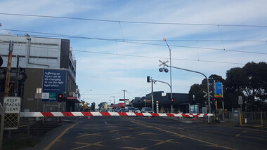
Photograph - Digital photograph, Lisa Gervasoni, Coburg Railway Gates, 2017, 2017
... , and preventing Bell Street traffic from crossing the railway line. ..., and preventing Bell Street traffic from crossing the railway line. Coburg ...Colour photograph of a Coburg railway boomgate down, and preventing Bell Street traffic from crossing the railway line. coburg, railway, gates, bell street, boom gate, boomgate, coburg railway gates -
 Phillip Island and District Historical Society Inc.
Photograph, Unknown
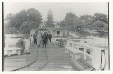
... with railway line, people, Jetty Shed and Isle of Wight... the Cowes Pier with railway line, people, Jetty Shed and Isle ...One of a collection of photographs donated by Mary KarneyBlack & White copy of photograph showing the Cowes Pier with railway line, people, Jetty Shed and Isle of Wight in the background.cowes pier phillip island, cowes jetty phillip island, jetty shed cowes pier, cowes forechore phillip island, mary karney -
 Whitehorse Historical Society Inc.
Photograph, Hall in Oval Way, Nunawading, 1998
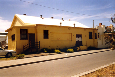
... Nunawading. Street runs next to the railway line on the northern side.... to the railway line on the northern side. Hall in Oval Way, Nunawading ...Coloured photograph of a yellow painted hall in Oval Way Nunawading. Street runs next to the railway line on the northern side.oval way, nunawading, halls -
 Surrey Hills Historical Society Collection
Photograph, Stirling Crescent, Surrey Hills in 1930s, 1930s
... and cars on the left and electricity poles and the railway line... on the left and electricity poles and the railway line on the right ...Paddy Slavin had a bakery at 118 Union Road, which had a rear exit onto Stirling Crescent. On the left is part of Paddy Slavin’s Bakery at 118 Union Road. The house with the hedge was that of Ada McBeath, organist for many years at the St Stephens Presbyterian and the Wyclif Churches, who lived at No.16 from 1900-1943. Phillip and Winifred Slavin are still listed in electoral roll in 1963 but by 1968 had moved to Gipps Street Collingwood, where he was still employed as a pastrycook. A black and white photograph of a street with some houses and cars on the left and electricity poles and the railway line on the right hand side.stirling crescent, surrey hills, bakery, streetscape, (ms) ada mcbeath, churches, organist, (mr) phillip slavin, (mrs) winifred slavin, streetscape, pastrycook, wyclif congregational church, (mr) paddy slavin, st stephens presbyterian church -
 Whitehorse Historical Society Inc.
Photograph - B/W Photograph, Station Master's House Station Street Mitcham, 1/09/1976 12:00:00 AM
... Street, Mitcham - was immediately alongside railway line - is now... alongside railway line - is now carpark. Station Master's House ...Black and white photo of Station Master's House, Station Street, Mitcham - was immediately alongside railway line - is now carpark.station master's house, mitcham -
 Ringwood and District Historical Society
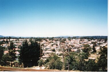
Photograph, View of Ringwood circa 1960's
... South from railway line New Street bridge. circa 1960's..." View of Ringwood looking South from railway line New Street ...Postcard size coloured photograph"Written on back of photograph" View of Ringwood looking South from railway line New Street bridge. circa 1960's -
Canterbury History Group
Photograph - Canterbury Park, c1990
... and railway line..... Includes Bowling green and railway line. Photograph Canterbury Park ...Black and White photograph of Canterbury Park from Canterbury Road looking towards the park. Includes Bowling green and railway line.canterbury, canterbury road, canterbury park, canterbury bowling club, railway lines -
 Bacchus Marsh & District Historical Society
Map, Maddingley Township, Parish of Parwan, 1880s
... such as the Bacchus Marsh Railway Station and line are shown on this map..., rivers, creeks, park lands, the railway line and Bacchus Marsh... such as the Bacchus Marsh Railway Station and line are shown on this map ...This map is dated Sept. 6th 1856. However places in the township of Maddingley which did not appear until the late 1880s such as the Bacchus Marsh Railway Station and line are shown on this map in their correct locations. This suggests the map has been derived from an earlier map. An earlier date of 1843 with a surveyor's name preceding it can also be seen on the map. The map is important because it indicates the location and dimensions of early but now discontinued use of land such as the showgrounds and police paddock and a site reserved for the Church of England which was not ultimately used for a permanent church. A single page paper map showing land allotments, streets, rivers, creeks, park lands, the railway line and Bacchus Marsh railway station in the township of Maddingley. The map is pasted into a bound volume containing 76 maps or plans in total. Bottom of Map: Surveyor-General's Office, Melbourne, Sept 6th, 1856bacchus marsh victoria maps, maddingley victoria maps, land use, maddingley victoria history -
 Bendigo Military Museum
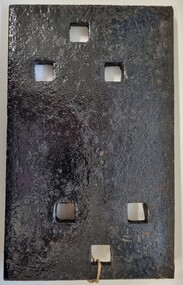
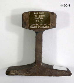
Memorabilia - RAIL SECTION AND CERTIFICATE, 1) est 1941-43, .2) 1984
... .1) A section of the "Thai-Burma Railway Line". A small... of the "Thai-Burma Railway Line". A small brass plaque is attached ...The items were presented to Alfred Robert Maskell VX25221, 4th Anti Tank Regt in May 1984. Alf worked on the Railway during 1942-43 as a Prisoner of war in horrendous conditions. Refer 2485 for medals and service history also 1076, 2484P..1) A section of the "Thai-Burma Railway Line". A small brass plaque is attached to one edge. .2) Certificate of "Authenticity Thai- Burma Railway memento". Yellow parchment paper with gold surround with blue print. A space for "Presented to and date, signed by". A brief story on the Railway Line. On the rear in one corner in ink "Slice No 131"..1) "Rail slice Thai-Burma Railway 1942-43 Australian Thai Chamber of Commerce"memorabilia, history, railways -
Glenelg Shire Council Cultural Collection
Photograph - Photograph - Portland Harbour, n.d
... showing Henty Park, canal, railway line & freight wagons, ring..., canal, railway line & freight wagons, ring road. Photograph ...Port of Portland Authority Archivesport of portland archives, portland harbour -
 Bendigo Historical Society Inc.
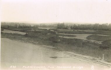
Postcard - ACC LOCK COLLECTION : FLAMICOURT FROM PERONNE BRIDGE - POSTCARD, 1914 - 1918
... from Peronne Bridge. Railway line and marshland.... Railway line and marshland in the foreground. Two copies A 30 ...Postcard, WW1, B & W image of Flamicourt in the distance from Peronne Bridge. Railway line and marshland in the foreground. Two copies A 30postcard, postcard, ww1, flamicourt, peronne bridge -
Clunes Museum
Map - MAPS
... TO MARYBOROUGH RAILWAY LINE.... CRESWICK CREEK - KILKENNY CREEK - BALLARAT TO MARYBOROUGH RAILWAY ...A MAP OF CLUNES TOWNSHIP. ORIGINAL AND COPY. ALL STREETS WITH ALLOTMENT NUMBERS CRESWICK CREEK - KILKENNY CREEK - BALLARAT TO MARYBOROUGH RAILWAY LINE.CLUNESlocal history, document, maps, clunes township -
 Whitehorse Historical Society Inc.
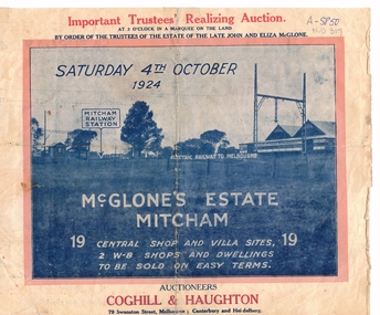
Document, McGlone Estate Mitcham
... and Mitcham Railway line and station... Railway line and station McGlone Estate Mitcham Document Document ...Pamphlet on auction of McGlone's Estate,Pamphlet on auction of McGlone's Estate, Mitcham 1924. Bordered by McGlone Street, Whitehorse Road, Station Street and Mitcham Railway line and stationPamphlet on auction of McGlone's Estate, land sales, auctions, mcglone estate, mcglone, john, elizabeth, station street, mitcham, whitehorse road, mitcham railway station, coghill & haughton -
Whitehorse Historical Society Inc.
Map, Mitcham Riding, n.d
... reserves, railway line.)... Roads) (Shows electric light mains. MMBW reserves, railway line ...Shire of Nunawading: Mitcham Riding [n.d.] (between Springvale and Mitcham Roads) (Shows electric light mains. MMBW reserves, railway line.)mitcham, maps, tunstall, forest hill -
Whitehorse Historical Society Inc.
Map, Mitcham Riding, n.d
... and railway line....) (Shows electric light mains, MMBW reserves and railway line ...Shire of Nunawading: Mitcham Riding [n.d.] between Mitcham and Heatherdale Roads) (Shows electric light mains, MMBW reserves and railway line.mitcham, maps, vermont -
 Southern Sherbrooke Historical Society Inc.
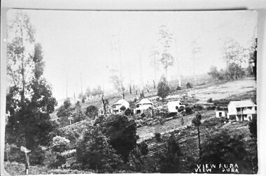
Photograph - View of Aura
... View of Aura (Menzies Creek) from the railway line... of Aura (Menzies Creek) from the railway line to Church Rd. Four ...View of Aura (Menzies Creek) from the railway line to Church Rd. Four houses can be seen on the low side of Church Rd. -
 Lakes Entrance Historical Society
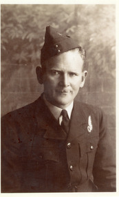
Photograph - Beveridge, 1945 c
... Beveridge in RAAF uniform, taken during survey of railway line... survey of railway line Melbourne to Orbost 1950 Photograph ...Black and white photograph of Flight Lieutenant Roy Beveridge in RAAF uniform, taken during survey of railway line Melbourne to Orbost 1950genealogy, raaf, railways -
Glenelg Shire Council Cultural Collection
Souvenir - Glass Ashtray, 1930s
... Glass ashtray, rectangular, View Ware. Image is of Railway...' Glass ashtray, rectangular, View Ware. Image is of Railway Line ...Glass ashtray, rectangular, View Ware. Image is of Railway Line, Whaler's Bluff and walkway to sea baths. Underside of base painted royal blue.Back: Red and black sticker 'EM JENKIN, BENTINCK ST, PORTLAND. NEWSAGENCY & LIBRARY'souvenir of portland, portland seafront, whalers bluff, portland baths -
Glenelg Shire Council Cultural Collection
Photograph - Photograph - Railway Construction, Port of Portland, n.d
... between a railway line and a concrete wall. Rear door on driver's... of a Holden Kingswood sedan, parked between a railway line ...Port of Portland Authority Archivesport of portland archives -
 Hume City Civic Collection
Photograph
... in the foreground. There are electric power lines along the railway line.... in the foreground. There are electric power lines along the railway line ...This image is of the Viaduct at Rupertswood across the Jacksons CreekA black and white photo of the viaduct at Rupertswood across the Jackson's Creek with several gum trees in the foreground. There are electric power lines along the railway line.rupertswood, jackson's creek, railways, bridges, george evans collection -
 Whitehorse Historical Society Inc.
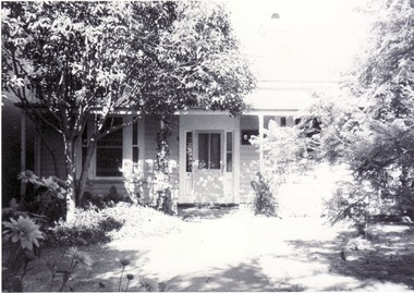
Photograph, Lion's Opportunity Shop, Blackburn, Taken 1998
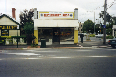
... Shop, Mitcham Road, Blackburn, just north of the railway line... Shop, Mitcham Road, Blackburn, just north of the railway line ...Coloured photograph of the Lion's Blackburn Opportunity Shop, Mitcham Road, Blackburn, just north of the railway line. The other road in the photograph is Railway Roadlion's opportunity shop, blackburn, opportunity shops -
 Kew Historical Society Inc
Photograph - Railway level crossing in Glenferrie Road, Glenferrie, E.J. Dower, c.1912
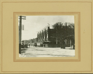
... of the regrading of railway line to Camberwell".... before the commencement of the regrading of railway line ...One of a series of photographs, taken by Edgar James Dower in the second decade of the twentieth century. Born and raised in Olinda, his family later moved to Surrey Hills. He worked as an adult as a clerk in the city office of the Metropolitan Gas Company, and in his role as a 'collector', he was able to photograph scenes including the construction of tramlines and associated buildings in Kew, Hawthorn, Camberwell and Surrey Hills. Later he established a real estate agency with his brother - the E.J. Dower Real Estate Agency, Dandenong Office.The image is an historically significant record of the development of transport infrastructure which was used to connect Victorians in the first two decades of the twentieth century. This development resulted from increases in population and the consequent extension of Melbourne's suburbs. The photographs, both individually and collectively, richly detail the labour of workers and the tools and machinery used to create and extend Melbourne's public transport network in the years preceding and during World War 1.Digital copy of an original mounted photograph showing Glenferrie Road Hawthorn, looking north towards the old railway level crossing that existed before the line was elevated on a bridge over Glenferrie Road. "The Don Store" at right is immediately behind the old railway level crossing. The tree and shops at left before the crossing were to be removed / demolished as part of the realignment of the train tracks.Annotated verso: "1914 [deleted]/1913 / Glenferrie Road showing railway gates / Taken just before the commencement of the regrading of railway line to Camberwell".theme --- travelling by tram, theme -- connecting victorians by transport and communications, glenferrie road -- hawthorn (vic.), railways -- hawthorn, the don store -- hawthorn (vic.) -
 Puffing Billy Railway
Axle Box Cover - Tasmanian Main Line Co, 1874
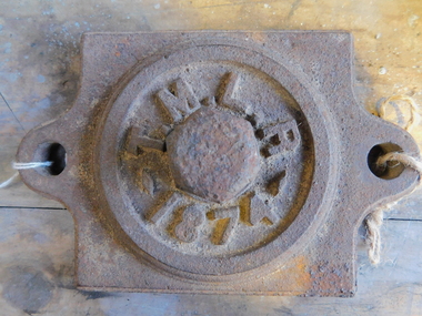
... axle, tasmanian main line railway, axle box, tasmania, main...Axle box cover from a Tasmanian Main Line Railway rail... Main Line Railway rail vehicle from 1874 The Tasmanian Main ...Axle box cover from a Tasmanian Main Line Railway rail vehicle from 1874 The Tasmanian Main Line Railway Company (T.M.R.L.) was a privately owned railway company that existed in Tasmania from 1872 to 1890. The company were the first operators of rail services between Hobart and Launceston, where it connected with the Launceston and Western Railway (L.W.R.) It started construction of a 3' 6" gauge line between Hobart and Launceston in 1873 which was completed in December 1875. and was officially opened on 1 November 1876. The route of the railway was selected largely as a result of vocal local interests and accordingly traversed some reasonably unfavorable topography, particularly in the southern section. Because the TMLR had limited finances, the line was built to the narrow (1067 mm) gauge and included long sections of steep gradients and sharp curves. The final eighteen kilometres of the route from Western Junction to Launceston used the existing broad gauge alignment of the Launceston and Western Railway, with a third rail being laid for use by the narrow gauge trains A close but uncomfortable relationship with the Government was resolved in 1890 with the purchase of the company's assets by the Crown and their incorporation into the Tasmanian Government Railways on 1 October 1890. Historic early Tasmanian Main Line Railway - Vehicle Axel Box cover Axle box cover from a Tasmanian Main Line rail vehicle from 1874.T.M.L.R - 1874 -axle, tasmanian main line railway, axle box, tasmania, main line,