Showing 11153 items
matching re-survey
-
 Whitehorse Historical Society Inc.
Letter - Correspondence, Re-enactment of the arrival in the City of Knox of first white settler, 1988
An invitation from the Mayor and Councillors of the City of Knox in conjunction with Knox Historical SocietyAn invitation from the Mayor and Councillors of the City of Knox in conjunction with Knox Historical Society to the President of Nunawading Historical Society to a re-enactment of the arrival of the first white settler to Knox, Rev James Clow.An invitation from the Mayor and Councillors of the City of Knox in conjunction with Knox Historical Society city of knox, knox historical society, nunawading historical society, clow, james (rev) -
 Flagstaff Hill Maritime Museum and Village
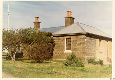
Photograph - Historical, Flagstaff Hill, The Lighthouse Keeper’s Cottage showing re-roofing carried out by Council, 1970s
The coloured photograph shows the Lighthouse Keepers' Quarters at Flagstaff Hill, Warrnambool. The building was erected in the 1850s on Middle Island, Lady Bay. It was relocated to its current location in the late 1870s along with the two lighthouses, the chart room and the privy. The Warrnambool City Council replaced the iron roof on the cottage in the 1970s and further work has since been carried out. The picture shows the poor condition of the stonework on the right hand side of the cottage. After the cottage ceased to be used by lighthouse keepers, it was rented out by various organisations and later became disused. The Historical Society requested the re-connection of power. The right hand side of the cottage was repurposed for use by Flagstaff Hill Maritime Museum and Village. in the 2020s it was restored and fitted out as the Alexander Farncombe room, which is used for temporary exhibitions. This photograph, a print, is one of a set of five that show the site of Flagstaff Hill. It is presumed to have been taken by John Lindsay, Founding Director of Flagstaff Hill Maritime Museum and Village. One of the photographs in the set has the pencil inscription "Photo J Lindsay". It was taken in the early 1970s during the initial stages of the development of Flagstaff Hill as a Museum and Maritime Village. The photographs belonged to the donor's grandparents, who lived in the Warrnambool district of Allansford/Naringal. The photograph is a record of the Lighthouse Keepers' Quarters at Flagstaff Hill Maritime Museum and Village before its development and opening in 1975. It shows the condition of the building at the time and some of the recent re-roofing. The photograph is significant for recording the condition of the original heritage listed building at that point in time.Coloured photograph, glassy print, one of a set of five. Photograph shows the Lighthouse Keepers' Quarters, focused on the Assistant's Quarters on the right. It shows the a new iron roof that had been installed by the Warrnambool City Council, and the condition of the bluestone,walls. There are clay chimney pots on the two chimneys. A set of steps are at the entry on the right hand side. The flagstaff is on the left of the photograph. The photograph's paper has the printer's watermark on the back. The early 1970s picture is presumed to have been photographed by John Lindsay, Warrnambool.Label on the back: "THE BLUESTONE COTTAGE SHOWING RE-ROOFING CARRIED OUT BY COUNCIL. The Historical Society has requested Council to have S.E.C. power re-connected"flagstaff hill maritime museum and village, warrnambool, maritime museum, shipwreck coast, 1970s, photograph, lady bay, flagstaff hill site, john lindsay, cannon emplacement, middle island, flagstaff, lighthouse keepers' quarters, lighthouse keepers' residence, alexander farncombe, re-roofing, s.e.c. connection -
 Phillip Island and District Historical Society Inc.
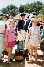
Photographs, Fuji Film, Re-enactment of the Landing of George Bass, 01/1998
A Plaque was erected on the occassion of the re-enactment. The wording is as follows: "In Recognition of a brave adventure on January 5 1998. Five men: Bern Cuthbertson (skipper), Tom O'Byrne (first mate), Craig Dixon, Rick McMahon and Geoff Zwan, landed in Flinders after 4 weeks at sea having rowed and sailed from Darling Harbour Sydney in the 'Elizabeth', a nine metre whale boat. This voyage re-enacted the discovery and naming of Western Port by Royal Navy Surgeon George Bass and his crew of five in 1798." They rowed an 8.7m long open whale boat some 1930 km from Port Jackson (Sydney).A collection of colour photographs taken at the re-enactment of the landing of George Bass. Showing "Sailors", a Canon, inside the boat, boats on the water and spectators on the foreshore.bass landing re-enactment 1998, george bass, san remo, p & e king -
 Kew Historical Society Inc
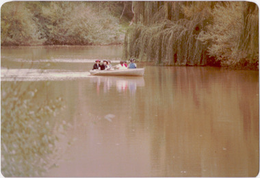
Photograph - Historic re-enactment during the Festival of Kew, 1978
At the 1978 Festival of Kew, a number of organisations, including the City of Kew, the Kew Historical Society, Trinity Boys Grammar School and local Girl Guides participated in a re-enactment of the expedition of the party of Charles Grimes in surveying the Yarra River as far as Kew in February 1803. The location for the event was Yarra Bend Park near the Studley Park Boat House. The event was organised by the Kew Historical Society. The re-enactment was captured by a number of amateur photographers as well as by a photographer from the local Progress Press.Local communities select events to commemorate according to their shared history and values. Commemorations of colonial exploration were popular with local historical groups such as the Kew Historical Society in the twentieth century. In re-enacting events such as the Grimes survey of the Yarra, students from a local school were encouraged to take on specific roles, including play-acting individuals involved in the survey party as well as members of the local Wurundjeri People. The photographs, taken by amateur and professional photographers, represent a period in time when the dominant values were those shared by the descendants of European settlers in Victoria. Original colour photographic positive showing six boys from Trinity Grammar School in a boat on the Yarra at Studley Park in a re-enactment of the survey party of Charles Grimes of February 1803.Annotated on reverse: "GRIMES PARTY COMING UP THE YARRA 1978 / TRINITY GRAMMAR BOYS IN RE-ENACTMENT / FESTIVAL CONTRIBUTION / BY KEW HISTORICAL SOCIETY"kew historical society, trinity grammar school, kew girl guides, city of kew, yarra river, charles grimes, collins expedition, wurundjeri people, yarra bend park, colonial surveys, historic re-enactments, festival of kew, kew festival -
 Kew Historical Society Inc
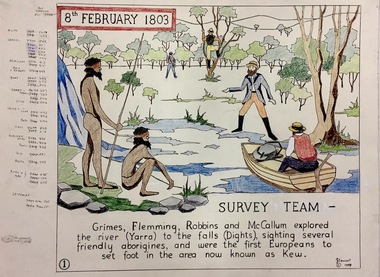
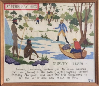
Work on paper, Joy Stewart, 1. Survey Team, 1988
Kew Tapestry. The eight panels depict the history of Kew. This was a 1988 Australian Bi-Centennial Project carried out under the auspices of City of Kew Council and the Kew Historical Society Incorporated. Nearly 600 citizens including many children participated in the production by adding a few or more stitches. A book records their names and the panels upon which they worked. Artist: Joy Stewart Co-ordinator: Dorothy BenyeiSydney Joy (Joy) Stewart was born in Melbourne 1925. She studied at Swinburne Technical College Art School from 1941-1945, then the National Gallery Art School 1946-1948. Her career included employment positions as a display artist, designer/painter, gallery assistant, and art teacher. Joy relocated to Cairns in 1981. Solo exhibitions in Melbourne and Cairns, including 'Done By Me' at Cairns Regional Gallery in 1999. Group exhibitions at Cairns Regional Gallery, 'The Fish John West Regrets, 1993' and 'Facets of Life' 1994. Joy Stewart died in Cairns in 2018.1. Survey Team. A Handcoloured cartoon created by the artist Joy Stewart as a template for the first of a series of embroidered panels depicting the history of Kew. Wool colour codes at left. Inscription: "8th February 1803. SURVEY. Grimes, Flemming (sic), Robbins and McCallum explored the river (Yarra) to the falls (Dights), sighting several friendly aborigines, and were the first Europeans to set foot in the area now known as Kew". Signed by the artist "(c) JStewart, 1988"bicentennial project (kew), joy stewart -
 Bendigo Military Museum
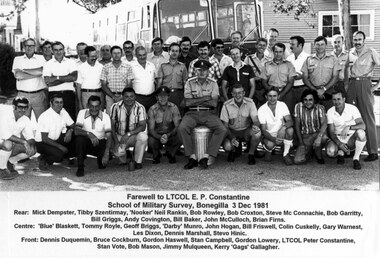
Photograph - RASvy Serving and Retired Personnel Farewelling LTCOL Peter Constantine AM at Bonegilla, VIC, 1981
This is a group photograph of RASvy serving and retired personnel at a farewell to LTCOL Peter Constantine AM, at the School of Military Survey, Bonegilla, VIC, 3rd December 1981. LTCOL Constantine was the CO of the Army Survey Regiment from 1975 to 1976 and CO of School of Military Survey (SMS) from 1976 to his retirement in January 1982. The contingent of serving and retired personnel from units across Australia travelled in civilian attire by bus to Bonegilla for the occasion culminating with a farewell dinner. Most personnel appearing in uniform were instructional staff from the SMS. LTCOL Constantine was one of RASvy’s most revered officers in this era, with 32 years of meritorious service as a leader on active duty in Vietnam in 1969 and the commanding officer of the Regiment and School. His memoirs of active duty in Vietnam ‘Surveyor - Printer Behind the Lines’ was published in 2022.This is a group photograph of RASvy serving and retired personnel at a farewell to LTCOL Peter Constantine AM, at the School of Military Survey, Bonegilla, VIC, 3rd December 1981. The photograph with annotated personnel was printed on photographic paper and is part of the Army Survey Regiment’s Collection. The photograph was scanned at 600 dpi. Serving and retired personnel are identified in the footnotes at the bottom of the photo. royal australian survey corps, rasvy, army survey regiment, army svy regt, fortuna, asr -
 Bendigo Military Museum
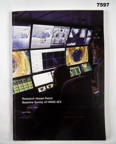
Book, Find AE1 Ltd & Australian National Maritime Museum, "RESEARCH VESSEL PETREL BASELINE SURVEY OF HMAS AE1", 2018
"Research Vessel Petrel - Baseline Survey of HMAS AE1" This book is a report of a comprehensive photographic survey completed on a c.1938 submarine wreck off the coast of PNG.Soft cover book. Cover - cardboard with white print on black and dark blue background on front and spine. Illustrated with colour photographs. Front cover - "RV Petrel control room during the survey". Back cover - "AE1 bow torpedo tube". 179 pages, cut, plain, white paper. Illustrated in black and white and colour photographs, maps and technical drawings.books, ww2, submarine, png, photographic -
 Federation University Historical Collection
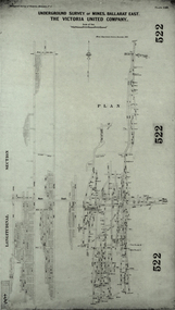
Plan, Underground Survey of Mines, Ballarat East. The Victoria United Company, 1903
Underground Survey of The Victoria United Company from Geological Survey of Victoria, Memoirs No. 4.ballarat east, victoria united company, cgt, mining, geological survey, longitudinal section -
University of Melbourne, Burnley Campus Archives
Document, 1979 - 81 Triennial Survey, 1978
TAFEC Triennial Survey, Dept. of Agriculture Triennial Surveys for TAFE and CAE courses. 3tafec, triennal survey, tafe, courses, department of agriculture -
 Bendigo Military Museum
Photograph - RASvy Surveyors in the field, c1950s – 1960s
This is a set of 1photographs of surveyors in the field measuring distances using chains, taking observations using theodolites and operating electric distance measurement equipment. They were probably employed in establishing mapping and geodetic control operations or the surveyors may have been in training. The photos were most likely taken in the 1950s and 1960s. Photos .1P to .6P feature personnel setting up geodetic survey chaining equipment to measure distances. The surveyor in Photo .5P is LTCOL Howard Angus Johnson MBE who served from 1936 to 1954. The RA Svy surveyor in photos .7P to .12P were using a theodolite to take angular measurements. They were usually supported by an observer who recording their readings on a booking form. The surveyor in Photo .10P and .11P is LTCOL Jorge Gruszka, who served from 1955 to 1985. He was CO of the Army Survey Regiment from 1982 to 1985. The surveyor in photo .13P is cutting an identification blaze on a tree using a hammer and chisel. The tellurometer in Photos .14P to .16P was a MRA1 microwave Electronic Distance Measuring instrument (EDM) introduced in 1958. It and later models were man-portable systems that improved geodetic survey efficiencies for rapid network extension and densification replacing triangulation with EDM and theodolite traverse sometimes using Bilby Towers to extend line lengths. The surveyor with the slouch hat is Colonel James ‘Jim’ Leslie Stedman, who served from 1941 to 1978. He was Director of Military Survey from 1975 to 1978 and was appointed as Colonel Commandant (honorary appointment, Retd) of the Royal Australian Survey Corps from 1978 to 1983. Jim Stedman is demonstrating EDM equipment.This is a set of 17 photographs of surveyors in the field measuring distances using chains, taking observations using theodolites and operating electric distance measurement (EDM) equipment. c1950s – 1960s. The photographs were printed on photographic paper and are part of the Army Survey Regiment’s Collection. The photographs were scanned at 300 dpi. .1) - Photo, black & white, c1950s, unidentified personnel using geodetic survey chaining equipment. .2) to .4) - Photo, black & white, c1950s, geodetic survey chaining equipment. .5) – Photo, black & white, c1950s, Jim Stedman using geodetic survey chaining equipment to measure distances. .6) - Photo, black & white, c1950s, Unidentified personnel geodetic survey chaining equipment. .7) – Photo, black & white, mounted on card, c1950s. Unidentified surveyor undertaking observations on a coral reef using a theodolite. .8) – Photo, black & white, c1950, unidentified surveyor undertaking observations with a Tavistock theodolite. .9) – Photo, black & white, mounted on green card, c1950s. Unidentified surveyor undertaking observations using a plane table. .10) – Photo, black & white, c1955, Jorge Gruszka undertaking observations with a theodolite. 7/55 Basic Survey Course Balcombe. .11) – Photo, black & white, c1950s, Jorge Gruszka undertaking observations with a theodolite. .12) – Photo, black & white, c1946-1948, unidentified surveyor undertaking observations with a theodolite to gain control for the mapping of the Snowy Mountain Diversion Scheme. .13) – Photo, black & white, c1950s, unidentified surveyor cutting a blaze in a tree. .14) and .15) – Photo, black & white, c1960s, Jim Stedman demonstrating EDM equipment. .16) – Photo, black & white, c1960s, L to R: Jim Stedman (probably) and unidentified surveyor demonstrating EDM equipment. .17) – Photo, black & white, c1950, unidentified surveyors undertaking observations with a theodolite in extreme conditions..1P on back - First Order Chaining Equipment .2P on back - First Order Chaining Equipment .3P on back - Full catenary 1800 – 1960 replaced by EDM .4P on back - First Order Chaining Equipment .5P on back - H.A. Johnson, Benambra baseline? 1st Order Chaining .6P on back - Chaining .7P on front - Difficult observing conditions especially when the tide is in. The station is sighted (sic) on a coral reef. .8P on back - Tavistock. .10P on back of duplicate in Photo Folder 14 – George (sic) Gruszka 7/55 Basic Survey Course Balcomme (sic) 1955/56 .14P and .15P on back - Jim Stedman demonstrating early EDM equipment.royal australian survey corps, rasvy, army survey regiment, army svy regt, fortuna, asr, surveying -
Moorabbin Air Museum
Newspaper (item) - Aviation 1970 - A Survey by The Australian Tuesday March 3 1970
A survey by Stanley Brogden -
 Otway Districts Historical Society
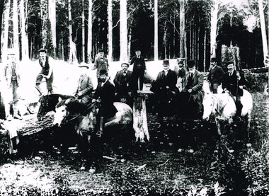
Photograph, Railway Survey Camp, Beech Forest, 4 Apr 1897, 4 April 1897
On the 18th August, 1896, the question of selecting localities for the permanent survey of a narrow-gauge line to Beech Forest from Colac was mooted. Two potential lines were examined. In a memorandum to the Minister for Railways, dated 23rd March, 1897, the Engineer-in-Chief recommended that the eastern and longer route via Lardner's Track be adopted. The second route, while identical from Colac to Gellibrand River, differed. By a more direct route the Beech Forest terminus is reached 5 miles sooner and cost approximately L24,500 less. The direct line would also serve a larger lot of settlers and would obtain a larger lot of traffic than the alternate proposal. The Parlimentary Standing Committee on Railways examined the proposal in situ and recommended that the direct route from Gellibrand to Beech Forest should be adopted and the Lardner's Track route should be abandoned at once.Photograph, Railway Survey Camp, 4 April 1897. Inspection of alternative routes by Parliamentary Committee on Railways.People named in the photograph.beech forest; railway; survey; victorian parliament; calcutt; fraser; e.h. cameron; d. mciville; a. harris; n. mcinnes; j.s. white; j. wood; t. baker; j. gardner; t.g. watson; standing committee; -
Stawell Historical Society Inc
Map, Geological Survey of Victoria
Geological Survey of Victoriastawell -
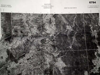 Bendigo Military Museum
Map - MAP, CUNUNGRA, QLD, Royal Aust. Survey Corps, 1955
Canungra was the Jungle Warfare Training Centre (JTC) before and including 1968. Item in the collection re Lt.Col. Swatton refer Cat No 6719.2P for his service details.This is a full size air photo map. It is black and white. Some natural features are labelled with white printing. The air photo has a white border of approx 6.5 cms size. Map information is printed in black ink around all four borders.Map data = Military survey Australia 1:25,999 Sheet No. 213/2 Zone 8. Scale 1:25,000. Date = The air photo was taken Jan 1955. Map produced by R.A. Survey Corps 1955.passchendaele barracks trust, survey map -
Port Melbourne Historical & Preservation Society
Letter - Department of Lands and Survey re proclaimation of Beach Street, Sandridge, Department of Lands and Survey, 16 Mar 1861
Handwritten letter on blue foolscap laid paper, from Dept of Lands and Survey 16.3.1861, directing attention to proclamation in Government Gazette re Beech Street (sic) Sandridgelocal government - borough of sandridge, engineering - roads streets lanes and footpaths -
 Flagstaff Hill Maritime Museum and Village
Map - Survey Map, F.F. McGovern, Yangery - County of Villiers, 1884
A surveyor was employed to measure the land designated as Yangery, County of Villiers, in the Borough of Warrnambool. The area on the map is similar to the earlier Farnham Survey undertaken by William Rutledge in the 1850's. Warrnambool was a Borough between 1863-1883. Coutours, waterways, sea and other significant points are shown. The distances are accurately measured. This survey map was used for planning future land sales, recreation areas and roads. WILLIAM RUTLEDGE (1806-1876) William Rutledge surveyed the land known as Farnham in southwest Victoria in 1843. His tenants made him a profitable business from working the land there. In 1863 Rutledge moved from nearby Port Fairy to Farnham and became very successful in breeding sheep, which he imported from J.R. Kirkham of Lincolnshire, England. He also bred horses on his land. The survey map of Yangery is important for its connection with renowned surveyor William Rutledge. The map shows the growth of landholders in the district when compared to the original Rutledge survey of the 1850's.Survey map of Yangery, titled "Yangery - County of Villiers". Printed on white paper, mounted on brown paper. c. 1863-1876. Comments printed on the Map include; Special Survey by William Rutledge, Photo-lithographed at the Department of Lands and Survey, Melbourne by W.J. Burson, Price 1/- [one shilling]. Scale is in Chains. Map has boundaries of Koroit Borough, Meerai, Purnim, Wangoom, Borough of Warrnambool, Mentions the Proposal of Tower HIll for Public Recreation. The map names the owners of the land at that time. Hand written pencil marks and figures and "Sauls fence" drawn on map. Hand written pencil markes and figures and "Sauls fence" drawn onto map. "For Department Use only". "Scale: 8 chains to 1 inch" flagstaff hill, warrnambool, shipwrecked-coast, flagstaff-hill, flagstaff-hill-maritime-museum, maritime-museum, shipwreck-coast, flagstaff-hill-maritime-village, county of villiers map, yangery district, w.j. burson, borough of warrnambool, koroit, purnim, meerai, wangoom, proposal of tower hill for public recreation, special survey by william rutledge, william rutledge, farnham, lincolnshire sheep, clydesdale -
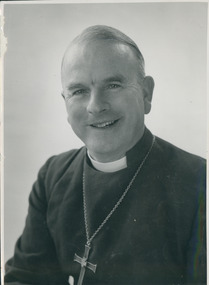 Uniting Church Archives - Synod of Victoria
Photograph, The Right Reverend RE Davies Bishop of Tasmania, 1977
Robert Edward Davies CBE (30 July 1913 – 17 May 2002) was the Anglican Bishop of Tasmania from 1963 to 1981. Educated at Queensland University, he was ordained in 1937 and began his career as an assistant priest at Christ Church Cathedral, Newcastle, NSW. After World War II service as a chaplain with Toc H and the Royal Australian Air Force he became Warden of St John’s College Brisbane. After this he was Archdeacon of Canberra, then Wagga Wagga. He became an assistant bishop of Newcastle and Warden of St John’s Theological College, Morpeth in 1960 and three years later the Tasmanian diocesan bishop. B&W head and shoulders studio photograph of Right Reverend Robert Edward Davies, Bishop of Tasmania."The Right Reverend RE Davies Bishop of Tasmania"davies, r. e., bishop -
 Bendigo Military Museum
Photograph - RA Svy Project C4 Aerodist Operation, Eastern Arnhem Land, NT, 1967
This is a set of 30 photographs of Royal Australian Survey Corps (RA Svy) personnel from Central Comd Fd Svy Unit (Adelaide) on Aerodist survey operation - Project C4 in Eastern Arnhem Land, Northern Territory in 1967. Photos of personnel were taken either at the operations base at Numbulwar or the main base at Gove (Nhulunbuy). RA Svy conducted nineteen Aerodist operations for 12 years from 1964 to 1975. Aerodist MRC2 was a tellurometer-based system adapted for aircraft to accurately measure distances between non-intervisible ground survey stations, using the aircraft as an intermediate station. Lower order geodetic results could be achieved by survey network trilateration. The measured distances between stations formed survey networks from which each station’s latitude and longitude was computed. Aerodist MRC2 was RA Svy’s major horizontal control survey tool for mainly medium scale topographic mapping (scale 1:100,000 Class A being spatially accurate to within 50 metres) in PNG, northern NT, north-west WA, Kalimantan Barat (West) Indonesia, Sumatra Indonesia, Gulf of Carpentaria and Cape York, QLD. In 1967, the Aerodist MRC2 Master equipment was installed in the aircraft featured in this set of photos, Executive Air Services’ (Essendon VIC) Grand Aero Commander VH-EXX. It was the same aircraft type and company contracted to Division of National Mapping for Aerodist MRC2 surveys. From July to October 1967 the aircraft was attached to Central Comd Fd Svy Unit (Adelaide - Major Don Ridge) on Project C4 eastern-Arnhem Land NT, where 317 Aerodist lines measuring 17,300 line miles were successfully completed. This was the most productive Aerodist project thus far. The most common helicopter used by RA Svy up to 1972 was the civilian Bell 47G-2 and the Sioux Light Observation Helicopters (LOH), the Australian Army’s equivalent featured in this photo set. These light observation helicopters had a limiting load carrying capacity of up to about 500 pounds. By comparison, one Aerodist team including two people weighed up to 1,500 pounds. Source: Royal Australian Survey Corps – Aerodist Years 1964-1975 by Peter Jensen. This is a set of 30 photographs of Royal Australian Survey Corps (RA Svy) personnel on Aerodist survey operations in Eastern Arnhem Land, Northern Territory in 1967. The photographs are on 35mm negative film and scanned at 96 dpi. They are part of the Army Survey Regiment’s Collection. .1) to .4) - black & white, 20th August 1967, Project C4 Aerodist Operations Base - Numbulwar, NT. .5) - Photo, black & white, 1967. Probable wrecked Indonesian fishing vessel. .6) to .8) - Photo, black & white, 1967. Unidentified survey operations base, L to R: unidentified personnel. .9) - Photo, black & white, 1967. Unidentified survey operations base, unidentified soldier driving a Haflinger 4x4 Light utility vehicle. .10) - Photo, black & white, 1967. Unidentified survey operations base, L to R: unidentified technician. .11) - Unidentified technician reading two survey altimeters to compute corrections to the measured distances for atmospheric refraction and to compute the sea level distances from the slope distances aircraft to the ground stations. .12) - Photo, black & white, 1967. Unidentified survey operations base, L to R: unidentified personnel. .13) to .16) - Photo, black & white, 1967. Unidentified personnel operating remote Aerodist MRC2 ground instruments. .17) to .18) - Photo, black & white, 1967. Unknown RA Svy office location. .19) to .20) - Photo, black & white, 1967. Aerodist MRC2 Master equipment. .21) to .22) - Photo, black & white, 1967. Aero Commander VH-EXX probably at Gove, NT, Central Comd Fd Svy Unit (Adelaide) – OC Major Don Ridge. .23) to .25) - Photo, black & white, 1967. Aero Commander VH-EXX probably at Gove, NT. Unidentified personnel. .26) - Photo, black & white, 1967. Aero Commander VH-EXX probably at Gove, NT. Aerodist antenna pods are visible on the aircraft. .27) to .29) - Photo, black & white, 1967. Australian Army Sioux Light Observation Helicopter (LOH) probably at Gove, NT. .30) - Photo, black & white, 1967. Panelled U337 survey station, visible as a white cross on aerial identification photo..1P to .2P – date and location on edge of film negative. .5P to .28P – no annotations .29P - annotated in white ‘RW-JEP Gove NT’ .30P - annotated in white ‘U337 Spool No1 Jun67’royal australian survey corps, rasvy, army survey regiment, army svy regt, fortuna, asr, aerodist, surveying, central comd fd svy unit -
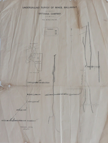 Federation University Historical Collection
Plan, Underground Survey of Mines, Ballaarat, Britannia Company, not dated
Printed underground survey of the Britannia Companyunderground survey, britannia company, last chance company, transverse section -
 Melbourne Tram Museum
Pamphlet, Yarra Trams, "Results of the Yarra Tram's new beginning survey", c1998
Pamphlet - DL - 3 fold, full gloss paper titled" Results of the Yarra Tram's new beginning survey" Looks at the results of a survey, both construction (eg maps, shelters, stop announcements), compliments etc. Main items were having daily tickets available on trams, re-introduce conductors, improve frequency, announcements and punctuality. Has a message from the CEO of Yarra at the time, Steve MacDonald. Two copies held.trams, tramways, yarra trams, surveys, conductors, tickets, tram stops -
 Bendigo Military Museum
Administrative record - Geodetic Survey and Topographical Mapping in Australia - Report by BP Lambert 1968, 1968
Australia is governed by a Federal Government and by six State Governments. National coordination of their respective geodetic survey and topographic mapping activities is effected on the advice of a National Mapping Council. Twenty years ago, at least 95% of Australia was poorly mapped and what maps existed were in need of revision. only a small area of the continent was covered by horizontal geodetic control and there was no scheme for a national levelling survey. Over the intervening period there has been an urgent and increasing demand for topographic maps varying from large scale contoured maps in support of specific engineering projects to rapid reconnaissance maps required for mineral prospecting in remote areas. Superimposed on this has been a defence requirement, specifically for military training areas, and generally for maps of the whole country. During the period much progress has been made. This paper reports on the progress from early colonial days through to the present time and finally hazards a prediction of future trends.Photocopy of 18-page typed report including diagrams, stapled top left-hand corner. Geodetic Survey and Topographic Mapping a Report by BP Lambert Director of National Mapping, Department of National Development, Canberra, Australia, 1968.royal australian survey corps, rasvy, fortuna, army survey regiment, army svy regt, asr, national mapping -
Lakes Entrance Regional Historical Society (operating as Lakes Entrance History Centre & Museum)
Book, O'Keefe, Brendan and Pearson, Michael, Federation. A National Survey of Heritage Places, 1998
A report of the results of a survey of heritage places connected with federation and the making of the Australian Constitution, including the documentation of a trial filed survey of ten selected places.federation, constitution, heritage -
Port Melbourne Historical & Preservation Society
Letter - Department of Lands and Survey re proclaimation for site of Town Hall, Sandridge, Department of Lands and Survey, 30 Dec 1861
Handwritten letter on blue foolscap laid paper, from Dept of Lands and Survey 30.12.1861 directing attention to proclamation in Government Gazette re site for Town Hall at Sandridge. Paper, watermarked with Britannia symbollocal government - borough of sandridge, port melbourne town hall -
4th/19th Prince of Wales's Light Horse Regiment Unit History Room
Booklet, Australian Army Manual of Land Warfare Part 2 Artillery Training Vol 3 Pam 3 Gun Regiments Survey within the Unit 1983, 1983
Soft covered booklet describing the principles and process of battery survey in a field artillery battery and that within the regiment, and the role organisation duties and deployment of a regimental survey section 7610-66-108-8454artillery, survey -
 Monbulk RSL Sub Branch
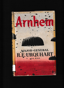
Book, RE Urquhart, Arnhem, 1958
Major-General Urquhart commanded the 1st British Airborne Division in Operation Market Garden, the greatest airbone assault of World War II, the struggle to capture Arnhem and win control of the bridge across the lower Rhine. The story of the 1st Airborne Division at Arnhem involved not only an Airborne Corps of three Divisions but also the bulk of the British 2nd Army in Europe. Gen. Urquhart has told the story of those fateful nine days clearly, frankly and, despite the terrible circumstances, not without humour.Index, maps, ill, p.239.non-fictionMajor-General Urquhart commanded the 1st British Airborne Division in Operation Market Garden, the greatest airbone assault of World War II, the struggle to capture Arnhem and win control of the bridge across the lower Rhine. The story of the 1st Airborne Division at Arnhem involved not only an Airborne Corps of three Divisions but also the bulk of the British 2nd Army in Europe. Gen. Urquhart has told the story of those fateful nine days clearly, frankly and, despite the terrible circumstances, not without humour. great britain - army - 1st airborne division, battle of arnhem 1944 -
 Ringwood and District Historical Society
Document - Copy of Lands Department Field Notes - Ringwood, Victoria, Field Notes 86.87/108 - Survey O.P. R72A dated August 1886 by Surveyor, L. Thorn
Foolscap size photocopies of survey maps with handwritten notations. -
 Ringwood and District Historical Society
Document - Copy of Lands Department Field Notes - Subdivision Sec E, Township of Ringwood, Victoria, Field Notes 1908/670 - Survey O.P. R72E dated November 1908
Foolscap size photocopies of survey maps with handwritten notations. -
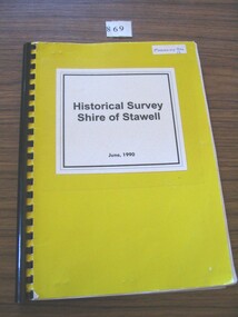 Stawell Historical Society Inc
Book, Stawell & Halls Gap Historical Societies, Historical Survey Shire of Stawell June 1990, 1990
Bright Yellow card cover & white white paper with titleHistorical Survey Shire of Stawell June 1990stawell heritage -
 Kew Historical Society Inc
Textile - Bicentennial tapestry, 1. Survey Team, 8th February 1803, 1988
This is one of eight embroidered panels, completed during the 1988 Australian Bi-Centennial, and carried out under the auspices of City of Kew Council and the Kew Historical Society. Nearly 600 residents, including many children, participated in their production by adding a few or more stitches. A book records their names and the panels upon which they worked. Artist: Joy Stewart / Co-ordinator: Dorothy Benyei.1. Survey Team. A framed embroidery created by adults and children of the City of Kew as a Bicentennial project, based on a design by the artist Joy Stewart. Five of the six completed embroideries created in the project are/were displayed in the Kew Library. [The five embroidered panels have now been temporarily removed for conservation reasons].Inscription: "SURVEY TEAM 8th February 1803 / Grimes, Flemming, Robbins and McCallum explored the river (Yarra) to the falls (Dights), sighting several friendly Aborigines, and were the first Europeans to set foot in the area now known as Kew." Embroidered signature of the artist: "(c) JStewart, 1988"bicentennial project (kew), joy stewart, charles grimes expedition, australian bicentennial -
 Ringwood and District Historical Society
Photograph, Ringwood Clocktower re-opening with returned soldiers, Maroondah Hwy, Ringwood - December, 1967
Catalogue card reads, 'Clocktower re-opening. Returned soldiers'.