Showing 2722 items
matching south side
-
 Surrey Hills Historical Society Collection
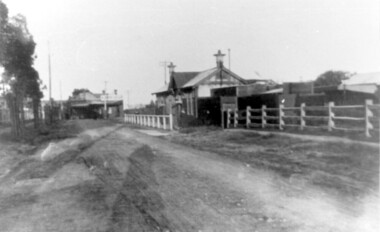
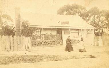
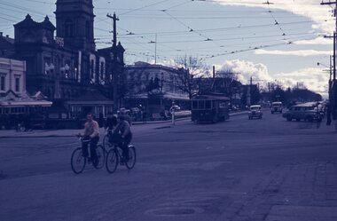
Photograph, Churchill Street, Mont Albert and Mont Albert Station, looking towards Hamilton Street, 1919, 1919
... by a syndicate of local landowners.The buildings on the south side... on the south side of the railway were built in 1910-1911 in the Arts ...The railway extended through to Mont Albert in 1882, but it wasn't until 1890 that a station was built with funds raised by a syndicate of local landowners.The buildings on the south side of the railway were built in 1910-1911 in the Arts and Crafts style by architect, K W Hardy. The land occupied by the Hamilton Street shops was subdivided in the 1880s and the first purpose-built shop was 'Pope and Moran, Grocers'. This shop later became Tom Morris' Grocery. By 1930 shops stretched along both sides of Hamilton Street and part way along Churchill Street. The donor, the late Norman Carter held a significant collection of photos taken around Mont Albert and Surrey Hills, in particular subjects related to the Church of England.Black and white photo taken from the centre of the road in Churchill Street, Mont Albert. Mont Albert station is on the RHS fenced off by a post and rail fence. Shops can be seen at the intersection of Hamilton and Churchill Streets. There do not appear to be any shops in Churchill Street. There are newly planted street trees within paling guards on the LHS. There does not appear to be any curb and channelling at the side of the road.Rear in blue biro in Jocelyn Hall's handwriting "Mont Albert Station 1919".mont albert station, railways, hamilton street, churchill street, shops, arts and crafts style, norman carter -
 Eltham District Historical Society Inc
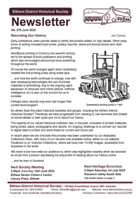
Journal - Newsletter, Newsletter, No. 270 June 2023
... - Saturday 1st July 2023 - Research Valley South Side • Eltham Horse... - Saturday 1st July 2023 - Research Valley South Side • Eltham Horse ...Contents: • Recording Our History by Jim Connor • Our Next Meeting - 2.00pm Saturday 10th June 2023 • Heritage Walk - Saturday 1st July 2023 - Research Valley South Side • Eltham Horse and Pony Club by Tony Brocksopp • What’s Happening by Liz Pidgeon • Frank’s New Shoes by Jim Connor • Many Hands Make Flags Fly!! By Terry Beaton • A Catalogue of Killings by Richard Pinn • Early Land Sale Documents • Annual General Meeting - Saturday 15th April 2023 • Eltham Cemetery Stories by Liz Pidgeon o Anne Hunniford, (Burgoyne) nee Hamilton, 1813-1899, Pioneer o Anne Jane Hunniford 1855-1927, Post Mistress The Shire of Eltham Historical Society was formed in October 1967. The first newsletter of the Society was issued May 1978 and has been published continuously ever since on a bi-monthly basis. With the cessation of the Shire of Eltham in late 1994, the Society's name was revised to Eltham District Historical Society and this name first appeared with issue No. 103, July 1995. The collection of the Society's newsletters provides a valuable resource on the history of the Society's activities, office bearers and committee members, guest speakers and subjects of historical interest pertinent to the former Shire of Eltham and the Eltham District.A4 newsletter distributed to members (Digital and A4 photocopy)newsletter, eltham district historical society -
 Whitehorse Historical Society Inc.
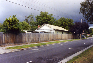
Photograph, Doncaster East Road, Mitcham, No.35, 2006
... Coloured photo of south - west side of the Winchcombe... road mitcham no.35 Coloured photo of south - west side ...Coloured photo of south - west side of the Winchcombe family home on the corner of Doncaster East and Glen Roads, Mitcham in 2006 Mrs. Winchcombe, nee Ireland is related to the Ireland family who were orchardists and florist in Mitcham area in the early 1900s.winchcombe family, ireland family, doncaster east road, mitcham, no.35 -
 Ballarat Tramway Museum
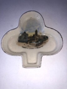
Functional Object - Ash Tray, Wiltshaw and Robinson, mid to late 1900's
... the Post Office looking at the buildings on the south side of Sturt... at the buildings on the south side of Sturt St including the Town Hall ...Demonstrates domestic items manufactured soon after the establishment of the tramway systems in Ballarat.Ash Tray - white glazed on front, unglazed rear with gold edge trim, light weight China in the shape of a "spade" with an image of the intersection of Sturt St and Lydiard St from the Post Office looking at the buildings on the south side of Sturt St including the Town Hall with two electric trams and the tram lines in the view. One of the trams is hauling a trailer. Possibly made mid to late 1900's. On rear has the makers stamp of "W&R Stoke on Trent" http://nicholnack.com.au/wiltshaw-robinson-patterns/index.php - accessed details that it is the mark of Wiltshaw and Robinson.tramways, trams, ash tray, sturt st, lydiard st, town hall -
 Ballarat Tramway Museum
Photograph - Digital image, John Ward, 20/08/1971 12:00:00 AM
... into Lydiard St North and tram 39 at the south side of the City tram... at the south side of the City tram stop at the corner. Has Craig's ...Yields information about the Sturt St and Lydiard St intersection just before closure and tram operations.Digital image of bogie tram 35 turning from Sturt St into Lydiard St North and tram 39 at the south side of the City tram stop at the corner. Has Craig's Hotel, the National Mutual building, Berry Anderson, Gemmola's Pharmacy, the Town Hall and the ANZ bank in the view. An Inspector can be seen near the tram stop. Photo taken from the Post Office tower. Photo by John Ward 20 August 1971. Slide title "04709 200871 7173-G SECV bogie trams 39 & 35 Sturt St to Lydiard St North Ballarat Vic"trams, tramways, sturt st, lydiard st, post office, city terminus, tram 39, tram 35 -
 Ballarat Tramway Museum
Slide - 35mm slide/s, Travis Jeffrey, 1961
... of No. 33 at City terminus, on the south side outbound. Tram..., on the south side outbound. Tram is in the process of being fitted ...Agfa plastic mount (blue base, white cover) of a photograph of No. 33 at City terminus, on the south side outbound. Tram is in the process of being fitted with dash canopy lights and tiger strips. Tram has destination of Grey St. Sebastopol and a SEC Briquettes advertisement on the front dash panel. Has a crewman with back to camera. Photo taken early 1961. Has Commonwealth Bank and Mutual Life building in the background. Slide rescanned at 3200 dpi 24-10-2020, jpg replaced, tiff file retained. This file was scanned in 2003 and may show colour changes."BAS 17" in penciltramways, trams, city terminus, sturt st, tram 33 -
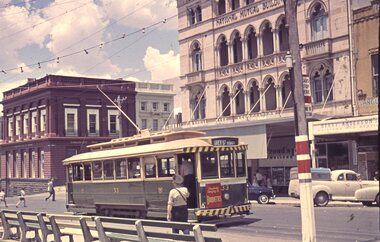
 Ballarat Tramway Museum
Slide - 35mm slide/s, Ben Parle, Jan. 1954
... . Photo of Ballarat No. 40 at the City Terminus, south side.... Photo of Ballarat No. 40 at the City Terminus, south side ...Kodachrome Transparency - 35mm slide - cardboard mount, with one side with red border and words "Kodachrome Transparency" top and bottom. On the other side is "Made in England" and "View from this side". Photo taken by Ben Parle 1/1954. Photo of Ballarat No. 40 at the City Terminus, south side of Sturt St at Lydiard St. Shows a number of passengers disembarking the tram. Tram has the destination of Gardens. The Town Hall has been decorated for the forthcoming Begonia Festival - note the sign and the lights. In the background are advertisements for Penfolds wine, Wardrops building, For high resolution scan see btm2812h.tif "Sturt St Ballarat" "1/54"tramways, trams, city terminus, lydiard st north, town hall, sturt st, passengers, tram 40 -
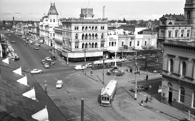
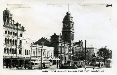 Ballarat Tramway Museum
Photograph - Black & White Photograph/s, Murray Views, Murray Views No. 26 City Hall and Sturt St Ballarat Vic, c1950
... and Sturt St, Ballarat Vic." No. 22 on south side and No. 34...." No. 22 on south side and No. 34 on north side - see Hi-Res scans ...Demonstrates a typical street view following the delivery of the bogie trams following the second world war and the street scape at the time. Able to determine the tramcar numbers. Yields information about the era of the photograph.B&W print, postcard print of Sturt St Ballarat, looking towards the Town Hall from the Post Office, City terminus. Photo taken by Murray Views to form "Murray Views No. 26, City Hall and Sturt St, Ballarat Vic." No. 22 on south side and No. 34 on north side - see Hi-Res scans. Has the National Mutual, Town Hall and Myers and other buildings in the view. Photo taken c1950, prior to renumbering of No. 22. 2nd copy added 28-12-2021 - most likely a reproduction of the original as it does not have a postcard back.On reverse side - black ink stamp "E.G.Butland" On reverse of 2nd copy - "Ballarat, Sturt St, west from Lydiard Sts" and Keith Kings stamp.tramways, trams, sturt st, bogie trams, tramway centre, town hall, tram 22, tram 34 -
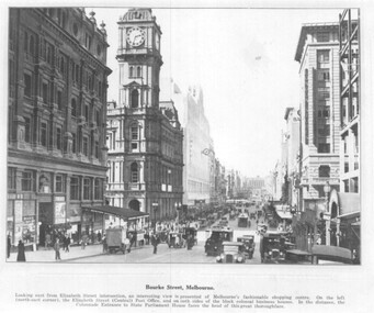 Melbourne Tram Museum
Photograph - set of 3 Black and White photographs, Tramway Museum Society of Victoria (TMSV), c1975
... and one motor car. Coles Book arcade on the south side. .3... car. Coles Book arcade on the south side. .3 - Similar ...Series of three Black & White Photographs of a postcards made by the TMSV Sales of: .1 - Bourke St, looking east with the GPO in Elizabeth St in the view, along with many vehicular traffic - has the Myer building. c1920? .2 - Bourke St looking west from Swanston St prior to the construction of the Myer building. c1910. Has a number of horse drawn vehicles in the view and one motor car. Coles Book arcade on the south side. .3 - Similar to .1, but c1910 - has L Cohen & Co, Tailors and Outfitters. in the view. All views have cable trams in the view.trams, tramways, bourke st, elizabeth st, gpo, cable trams -
 Ballarat Tramway Museum
Postcard, SEM Co, "Sturt St from PO Steps, Ballarat", c1908
... ESCo tram and crowds or onlookers on either side of the south... on either side of the south side of Sturt St. Has a detailed image ...Photograph - looking from Summerscales offices onto the intersection of Sturt and Lydiard St during an event, with a parked ESCo tram and crowds or onlookers on either side of the south side of Sturt St. Has a detailed image of the tram. C1909. In the background are Craigs Hotel, C. Marks & Co, National Mutual building, Snows, and the Town Hall. Several horse-drawn vehicles are in the photograph. Also, A. E. Casley Chemists and Beath Schiess & Co, though this seems to be almost printed into the photograph - above the chemist shop. The postcard has been sent to Miss N Sproston of Skeleton Cottage, Avoca. Has a 1d Victoria stamp and has been postmarked 14-5-1908. See item 5907 for a black-and-white image of the same postcard published by Summerscales.Yields information about the streetscape of Sturt St and Lydiard Streets c1908Postcard coloured, divided back, used, SEM Co.See image 2 for letter and address details. tramways, trams, esco, sturt st, events, lydiard st -
 Kew Historical Society Inc
Photograph - Yarra Valley Floods: Kew East, 1916
... century, the land abutting the south side of the Yarra in Kew... the south side of the Yarra in Kew was devoted to dairy farming ...Flooding of the Yarra Valley, including that section of the Yarra bordering Kew and Kew East in the north and west of the municipality, was a regular occurrence. Extreme flood events of the Yarra River are recorded to have occurred in 1891, 1901, 1916, 1923 and 1934. The Municipality of Kew's response to these floods was to enact planning decisions restricting residential development in flood prone areas following the floods of 1916, 1921 and 1934. While floods continued after the development of the Upper Yarra Reservoir (construction 1948-57), the regularity and extent of these inundations diminished. During the nineteenth century, the land abutting the south side of the Yarra in Kew was devoted to dairy farming. In the twentieth century, before and after the construction of the Eastern Freeway, much of this low-lying area was used as golf courses and public parks.One of a collection of photographs of flooding in the Kew section of the Yarra Valley which are in important research resource for the location and extent of flooding in the first half of the twentieth century. Flooding of the Yarra Valley at East Kew in 1916. The view is taken from the intersection of Kilby Road with what is believed to be Birdwood Street, looking across the flood waters to Ivanhoe. The extensive flooded area shown in the photograph would have included the Kew Golf Club. Verso: "Floods along Kilby Road / near Birdwood St? & Kilby Road / 1917? / 87yarra river, yarra valley, floods -- kew, kilby road -- kew (vic.), kew golf club -
 Kew Historical Society Inc
Photograph - Yarra Valley Floods: Kew East, 1916
... century, the land abutting the south side of the Yarra in Kew... the south side of the Yarra in Kew was devoted to dairy farming ...Flooding of the Yarra Valley, including that section of the Yarra bordering Kew and Kew East in the north and west of the municipality, was a regular occurrence. Extreme flood events of the Yarra River are recorded to have occurred in 1891, 1901, 1916, 1923 and 1934. The Municipality of Kew's response to these floods was to enact planning decisions restricting residential development in flood prone areas following the floods of 1916, 1921 and 1934. While floods continued after the development of the Upper Yarra Reservoir (construction 1948-57), the regularity and extent of these inundations diminished. During the nineteenth century, the land abutting the south side of the Yarra in Kew was devoted to dairy farming. In the twentieth century, before and after the construction of the Eastern Freeway, much of this low-lying area was used as golf courses and public parks.One of a collection of photographs of flooding in the Kew section of the Yarra Valley which are in important research resource for the location and extent of flooding in the first half of the twentieth century. Flooding of the Yarra Valley at East Kew in 1916. The view is taken from a street (maybe Birdwood Avenue) intersecting with Kilby Road looking northeast across the flood waters to Ivanhoe and Heidelberg. The extensive flooded area shown in the photograph would have included remnant dairy farms and the Kew Golf Club. Verso: "Floods / Yarra River / East Kew / Kilby Road / 1917? / 87"yarra river, yarra valley, floods -- kew, kilby road -- kew (vic.), kew golf club -
 Kew Historical Society Inc
Photograph - Flooding of the Yarra Valley at Kew East, 1974
... century, the land abutting the south side of the Yarra in Kew... the south side of the Yarra in Kew was devoted to dairy farming ...Flooding of the Yarra Valley, including that section of the Yarra bordering Kew and Kew East in the north and west of the municipality, was a regular occurrence. Extreme flood events of the Yarra River are recorded to have occurred in 1891, 1901, 1916, 1923 and 1934. The Municipality of Kew's response to these floods was to enact planning decisions restricting residential development in flood prone areas following the floods of 1916, 1921 and 1934. While floods continued after the development of the Upper Yarra Reservoir (construction 1948-57), the regularity and extent of these inundations diminished. During the nineteenth century, the land abutting the south side of the Yarra in Kew was devoted to dairy farming. In the twentieth century, before and after the construction of the Eastern Freeway, much of this low-lying area was used as golf courses and public parks.Late example of the capacity of the Yarra Valley at Kew to flood, even though drainage works and the Upper Yarra Reservoir had reduced their regularity.Original black and white print photograph of the low-lying land at East Kew under floodwater on 16 May 1974. The vantage point of the photographer is Lister Street. In the photo, the fences of the Kilby Farm can be seen. Flooding was caused by overflowing water in Glass' Creek and the River Yarra. Annotation verso: "Hay's Paddock op No.30 Lister Street / 16 May 1974 11.50am / R.L. 46.04"hays paddock, floods, yarra river, glass' creek, lister street -
 Kew Historical Society Inc
Photograph - Flooding of the Yarra Valley at Kew East, 1974
... century, the land abutting the south side of the Yarra in Kew... the south side of the Yarra in Kew was devoted to dairy farming ...Flooding of the Yarra Valley, including that section of the Yarra bordering Kew and Kew East in the north and west of the municipality, was a regular occurrence. Extreme flood events of the Yarra River are recorded to have occurred in 1891, 1901, 1916, 1923 and 1934. The Municipality of Kew's response to these floods was to enact planning decisions restricting residential development in flood prone areas following the floods of 1916, 1921 and 1934. While floods continued after the development of the Upper Yarra Reservoir (construction 1948-57), the regularity and extent of these inundations diminished. During the nineteenth century, the land abutting the south side of the Yarra in Kew was devoted to dairy farming. In the twentieth century, before and after the construction of the Eastern Freeway, much of this low-lying area was used as golf courses and public parks.Late example of the capacity of the Yarra Valley at Kew to flood, even though drainage works and the Upper Yarra Reservoir had reduced their regularity.Original black and white print photograph of the low-lying land at East Kew under floodwater on 16 May 1974. The vantage point of the photographer is Lister Street. Flooding was caused by overflowing water in Glass' Creek and the River Yarra. Annotation verso: "Lister Street looking north / Flood level / 16 May 1974 11.30am / R.L. 46.04"hays paddock, floods, yarra river, glass' creek, lister street -
 Kew Historical Society Inc
Photograph - Flooding of the Yarra Valley at Kew East, 1974
... century, the land abutting the south side of the Yarra in Kew... the south side of the Yarra in Kew was devoted to dairy farming ...Flooding of the Yarra Valley, including that section of the Yarra bordering Kew and Kew East in the north and west of the municipality, was a regular occurrence. Extreme flood events of the Yarra River are recorded to have occurred in 1891, 1901, 1916, 1923 and 1934. The Municipality of Kew's response to these floods was to enact planning decisions restricting residential development in flood prone areas following the floods of 1916, 1921 and 1934. While floods continued after the development of the Upper Yarra Reservoir (construction 1948-57), the regularity and extent of these inundations diminished. During the nineteenth century, the land abutting the south side of the Yarra in Kew was devoted to dairy farming. In the twentieth century, before and after the construction of the Eastern Freeway, much of this low-lying area was used as golf courses and public parks.Late example of the capacity of the Yarra Valley at Kew to flood, even though drainage works and the Upper Yarra Reservoir had reduced their regularity.Original black and white print photograph of Hay's Paddock under floodwater on 16 May 1974. The vantage point of the photographer is Keystone Crescent looking east. Flooding was caused by overflowing water in Glass' Creek and the River Yarra. Annotation verso: "Keystone Cr looking east / 16 May 1974 11.50am"hays paddock, floods, yarra river, glass' creek -
 Kew Historical Society Inc
Photograph - Flooding of the Yarra Valley at Kew East, 1974
... century, the land abutting the south side of the Yarra in Kew... the south side of the Yarra in Kew was devoted to dairy farming ...Flooding of the Yarra Valley, including that section of the Yarra bordering Kew and Kew East in the north and west of the municipality, was a regular occurrence. Extreme flood events of the Yarra River are recorded to have occurred in 1891, 1901, 1916, 1923 and 1934. The Municipality of Kew's response to these floods was to enact planning decisions restricting residential development in flood prone areas following the floods of 1916, 1921 and 1934. While floods continued after the development of the Upper Yarra Reservoir (construction 1948-57), the regularity and extent of these inundations diminished. During the nineteenth century, the land abutting the south side of the Yarra in Kew was devoted to dairy farming. In the twentieth century, before and after the construction of the Eastern Freeway, much of this low-lying area was used as golf courses and public parks.Late example of the capacity of the Yarra Valley at Kew to flood, even though drainage works and the Upper Yarra Reservoir had reduced their regularity.Original black and white print photograph of the low-lying land at East Kew under floodwater on 16 May 1974. The vantage point of the photographer is Lister Street. Flooding was caused by overflowing water in Glass' Creek and the River Yarra. Annotation verso: "Lister St looking same as No.3 / 16 May 1974 11.30"floods, yarra river, glass' creek, lister street -
 Kew Historical Society Inc
Photograph - Flooding of the Yarra Valley at Kew East, 1974
... century, the land abutting the south side of the Yarra in Kew... the south side of the Yarra in Kew was devoted to dairy farming ...Flooding of the Yarra Valley, including that section of the Yarra bordering Kew and Kew East in the north and west of the municipality, was a regular occurrence. Extreme flood events of the Yarra River are recorded to have occurred in 1891, 1901, 1916, 1923 and 1934. The Municipality of Kew's response to these floods was to enact planning decisions restricting residential development in flood prone areas following the floods of 1916, 1921 and 1934. While floods continued after the development of the Upper Yarra Reservoir (construction 1948-57), the regularity and extent of these inundations diminished. During the nineteenth century, the land abutting the south side of the Yarra in Kew was devoted to dairy farming. In the twentieth century, before and after the construction of the Eastern Freeway, much of this low-lying area was used as golf courses and public parks.Late example of the capacity of the Yarra Valley at Kew to flood, even though drainage works and the Upper Yarra Reservoir had reduced their regularity.Original black and white print photograph of the low-lying land at East Kew under floodwater on 16 May 1974. The vantage point of the photographer is at Willsmere Road. The road itself is underwater.Annotation verso: "Willsmere Rd / Same as No.7 / 16 May 1974 11.15am"floods, yarra river, willsmere road -
 Kew Historical Society Inc
Photograph - Flooding of the Yarra Valley at Kew East, 1974
... century, the land abutting the south side of the Yarra in Kew... the south side of the Yarra in Kew was devoted to dairy farming ...Flooding of the Yarra Valley, including that section of the Yarra bordering Kew and Kew East in the north and west of the municipality, was a regular occurrence. Extreme flood events of the Yarra River are recorded to have occurred in 1891, 1901, 1916, 1923 and 1934. The Municipality of Kew's response to these floods was to enact planning decisions restricting residential development in flood prone areas following the floods of 1916, 1921 and 1934. While floods continued after the development of the Upper Yarra Reservoir (construction 1948-57), the regularity and extent of these inundations diminished. During the nineteenth century, the land abutting the south side of the Yarra in Kew was devoted to dairy farming. In the twentieth century, before and after the construction of the Eastern Freeway, much of this low-lying area was used as golf courses and public parks.Late example of the capacity of the Yarra Valley at Kew to flood, even though drainage works and the Upper Yarra Reservoir had reduced their regularity.Original black and white print photograph of the low-lying land at East Kew under floodwater on 16 May 1974. The photograph is of Hyde Park looking north-east.Annotation verso: "Hyde Park looking nth-east / Flood Level / 16 May 1974 11.15am / R.L. 46.61"floods, yarra river, hyde park -
 Kew Historical Society Inc
Photograph - Flooding of the Yarra Valley at Kew, 1974
... century, the land abutting the south side of the Yarra in Kew... the south side of the Yarra in Kew was devoted to dairy farming ...Flooding of the Yarra Valley, including that section of the Yarra bordering Kew and Kew East in the north and west of the municipality, was a regular occurrence. Extreme flood events of the Yarra River are recorded to have occurred in 1891, 1901, 1916, 1923 and 1934. The Municipality of Kew's response to these floods was to enact planning decisions restricting residential development in flood prone areas following the floods of 1916, 1921 and 1934. While floods continued after the development of the Upper Yarra Reservoir (construction 1948-57), the regularity and extent of these inundations diminished. During the nineteenth century, the land abutting the south side of the Yarra in Kew was devoted to dairy farming. In the twentieth century, before and after the construction of the Eastern Freeway, much of this low-lying area was used as golf courses and public parks.Late example of the capacity of the Yarra Valley at Kew to flood, even though drainage works and the Upper Yarra Reservoir had reduced their regularity.Original black and white print photograph of the low-lying land at East Kew under floodwater on 16 May 1974. The photograph is taken from 43 Kellett Grove.Annotation verso: "Kellett Gve No.43 / Flood Level / 16 May 1974 11.40am"floods, yarra river, kellett grove -
 Melbourne Tram Museum
Photograph - Bourke St from William St looking west - cable trams, c1910
... with on the south side of Bourke Street the former St. James Building... with on the south side of Bourke Street the former St. James Building ...Photograph shows the view from William St looking west along Bourke St. Has two cable tram sets in the view, along with on the south side of Bourke Street the former St. James Building, Gollin & Company Building, then over King Street, Bourke Street West Police Station, McLean Bros. & Rigg Ironmongery & Hardware Store, (later Hudon's Store) and the Tramways Head Office Building. On the northside of Bourke Street is the Massey-Harris Building, John Connell & Co. Pty Ltd "Gresham House" and over King Street, H.V. McKay Harvester's Sunshine Head Office. Also in the distance is the Spencer Street Railway Station buildings. The Archway visible through the St. James Building led into the former Lt. James Street. Yields information about Bourke Street between 1909 and 1913Photograph - sepia toned on A4 sheetHas TMSV Sales stamp on rear.trams, bourke st, william st, cable trams, tramways, tram 402, st. james building -
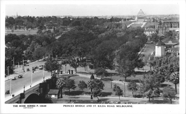 Melbourne Tram Museum
Postcard, Rose Stereograph Co, "Princes Bridge and St Kilda Road Melbourne", late 1930s
... of the photo. The road on the south side of the Yarra River... on the south side of the Yarra River, at the bottom of the photo ...Rose Series postcard No. P 10649, titled "Princes Bridge and St Kilda Road Melbourne", looking south from Flinders St station clock tower showing Princess Bridge and St. Kilda Road with a W2 class tram in the view at the intersection of City Road to the west and Alexandra Avenue to the east. In the background is the Shrine of Remembrance. To the west of St. Kilda Road running in parallel from City Road to Mafra Street is Sloss Street, it was removed in the late 1960' for the construction of the National Arts Center. The former "Green Mill" dance hall built in 1926 become the "Forty Club" in 1933 and evolved to being the "Trocadero Palais" by the late 1930's can be seen on the right of the photo. The road on the south side of the Yarra River, at the bottom of the photo, is Riverside Avenue. Yields information about St Kilda Road, late 1930s.Postcard - printed real photograph with Rose Stereograph Co. name on the rear.trams, shrine of remembrance, st kilda road, princes bridge, w2 class, tramways -
 Ringwood and District Historical Society
Photograph, Ringwood's first post office showing first postmistress, Miss M. Thompson. 1890
... ". (South side of Main Street (Maroondah Highway), approximately 300.... Thompson and her mother. 1890". (South side of Main Street ...Typed below photograph, "Ringwood's first Post Office showing first Postmistress, Miss M. Thompson and her mother. 1890". (South side of Main Street (Maroondah Highway), approximately 300 meters west of Ringwood Railway Station). Writing on back of original photograph reads, "Grandma and Auntie Martha Thomson 1890". Stamps on back of photograph read, "Wall Bros. Photographers ... St. Kilda". Other stamp reads, "R.J.T. Futcher, Geelong, Victoria, Australia". -
 Ballarat Tramway Museum
Slide - 35mm slide/s - set of 2, Robert Thomson, mid 1960's
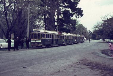
... of a line up of trams in Wendouree Parade, on the south side..., on the south side of Gardens Loop during an enthusiasts tram tour. mid ...Yields information about tours on the Ballarat system by enthusiasts. Date unknown, mid 1960's.Set of two AGFA blue / white plastic mount, colour slides of a line up of trams in Wendouree Parade, on the south side of Gardens Loop during an enthusiasts tram tour. mid 1960's? .1 - 3 bogie cars (lead by 42) showing Special and a single truckers. Has a number of crews standing around. .2 - Similar photo, but with all the trolley poles turned around with the No. 21 at the rear. A group of people can be seen at the far end. Not known if taken on the same date. all trams have the white dash panel but still have the white on black destination rolls.tramways, trams, tours, wendouree parade, special trams, crews, tram 42, tram 21 -
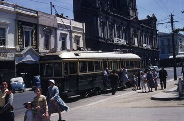
 Ballarat Tramway Museum
Slide - 35mm slide/s, Travis Jeffrey, 1961
... of No. 41 at City terminus, on the south side outbound..., on the south side outbound with passengers boarding the tramcar ...Agfa plastic mount (blue base, white cover) of a photograph of No. 41 at City terminus, on the south side outbound with passengers boarding the tramcar and others walking up to it. Tram is in the process of being fitted with dash canopy lights and tiger strips and has roof advertisements for Admiral TV and other electrical products. Tram has destination of Gardens via Drummond North. Photo taken early 1961. Has Commonwealth Bank and Mutual Life building in the background. Slide rescanned at 3200 dpi 24-10-2020, jpg replaced, tiff file retained. This file was scanned in 2003 and may show colour changes."BAS 19" in penciltramways, trams, city terminus, sturt st, tram 41 -
 Ballarat Tramway Museum
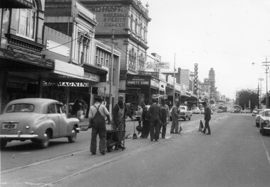
Photograph - Black & White Photograph/s, The Courier Ballarat, 20/09/1966 12:00:00 AM
... on the south side of Bridge St, including Magnin, a Disposal Variety... and the buildings on the south side of the street. tramways trams Bridge St ...Demonstrates nature and size of gang undertaking road repairs during 1966 in Bridge St and the buildings on the south side of the street.Black and White copy photograph of a newspaper photograph taken by The Courier, taken 20/9/1966, published 21/9/1966 of track repairs in Bridge St. Shows the nature of the work, and the level of the traffic in the streets at the time. Eight men working in the view. In the background are the buildings on the south side of Bridge St, including Magnin, a Disposal Variety store, Faull's Foot rest, and Dickins. In the far distance are two trams parked in the loop. Collected by Alan Bradley from the Ballarat Courier early 1980's. See Excel file "Record of Ballarat Courier Photos SEC era" (Archive Documents) for source of details.On rear stamped "Copyright, The Ballarat Courier Proprietary Limited." and "85%" in ink.tramways, trams, bridge st, road works -
 Ballarat Tramway Museum
Slide - 35mm slide/s, Ben Parle, Apr. 1956
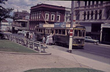
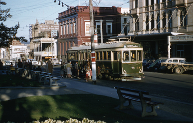
... waiting on the north side, a bogie car on the south side... on the south side, with a number of vehicles in the background. Slide ...Agfacolour slide with words "Agfacolour" in blue top and bottom on one side, white cardboard mount with thick blue border on the printed side. Possibly hand done. Photo taken by Ben Parle 8/1956. Photo taken from the Ballarat Post Office footpath looking across to the Town Hall, with a single truck tramcar waiting on the north side, a bogie car on the south side, with a number of vehicles in the background. Slide is very dark/blue colour. The Town Hall has large numerals "100" in white, with the word "1855" apparent on the nearest side. The corresponding year is partially hidden by trees."Sturt Street Ballarat" "8/56"tramways, trams, sturt st, town hall -
 Ballarat Tramway Museum
Slide - 35mm slide/s, Ben Parle, 8/04/1958 12:00:00 AM
... Terminus, south side. Tram has the destination of Gardens via..., south side. Tram has the destination of Gardens via Drummond ...Kodachrome Transparency - 35mm slide - cardboard mount, with one side with red border and words "Kodachrome Transparency / Processed by Kodak" top and bottom. Photo taken by Ben Parle 8/4/1958, date stamped onto slide. Has slide No. "2" stamped in red in top corner. Photo of Ballarat 34 at the City Terminus, south side. Tram has the destination of Gardens via Drummond North. A number of passengers boarding the tram. Has the Commonwealth bank, National Mutual Life Association building, Berry Anderson and Odeon Theatre in the background. For high resolution scan see btm2875.tif"Sturt St / Lydiard St" / "8-4-58"tramways, trams, sturt st, city terminus, lydiard st, tram 34 -
 Kew Historical Society Inc
Map, MMBW, MMBW Plan No.117 Heidelberg & Kew, 1900-1910
... the natural landscape and limited development on the south side... development on the south side of the Yarra River. In the Kew section ...The Melbourne and Metropolitan Board of Works (MMBW) was established by an act of the Victorian Parliament in 1890 to prepare for and to implement a sewerage and water reticulation system across what was then inner Melbourne, its surrounding and middle distance suburbs, including Kew. The MMBW was disbanded in 1991.The map collection of the Kew Historical Society has at its core the historic maps assembled and originally stored in the City Engineer's Department of the City of Kew. These include maps in a number of scales. The vast majority of maps were produced by the MMBW in the first two decades of the twentieth century, and are solid working maps, backed by linen for durability. These maps are historically significant to Kew, the City of Boroondara and to the history of the development of state utilities in Victoria. A number of the Kew maps have additional details added by former municipal officers, including the levels reached by various floods. As these were working documents, information was added to them long after the period of their initial production and distribution.Early map of part of the Borough of Kew, created in the early twentieth century, at a scale 160 ft to 1 inch. The map covers what was then the north eastern part of Kew showing the natural landscape and limited development on the south side of the Yarra River. In the Kew section, south of the river, the land is occupied currently by the Greenacres and Kew Golf Clubs. The map shows the extent of urban development by that time and the outlines of the few built structures in the municipality. The height above sea level of all parts of the landscape are indicated numerically in feet. Contour lines and the levels of historic floods were added in ink to the map at a later stage. MELBOURNE AND METROPOLITAN BOARD OF WORKS / PLAN NO. 117 / HEIDELBERG & KEW melbourne & metropolitan board of works, mmbw maps, borough of kew, cartography, mmbw plan no. 117, kew (vic.) -- maps, heidelberg (vic.) -- maps -
 Wodonga & District Historical Society Inc
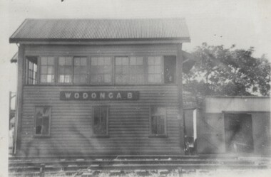
Photograph - Fred Rochow Railways Collection - Signal Box B, Wodonga Station, Before 1964
... Signal Box B was located on the south-east side of the High... was located on the south-east side of the High Street level crossing ...The Fred Rochow Railways Collection incorporates photos related to the operation of the Wodonga Railway Station including different types of trains and railways staff C. 1930 – 1990. It was donated to the Wodonga Historical Society by Fred Rochow, a railwayman who spent many years based in Wodonga. He joined the Victorian Railways on 17th June l947 and retired in 1988. For some time, he was a member of the Australian Federated Union of Locomotive Enginemen and served a term as a member of the Trades Hall Council. He had an extensive knowledge of the struggles that took place to achieve better conditions for railway workers. Fred worked for many years as a fireman and then worked his way up the ranks to driver, experiencing many changes from the days of steam locomotives through to diesel trains, locomotives and even the modern XPT train. He worked throughout Victoria at different stages of his career, with his final working years focused on the northeast of Victoria and the Albury to Melbourne line. After his retirement, Fred continued to share his love of steam miniature trains with the community.This collection has local and statewide significance as it captures images of trains, locomotives and personnel who operated the railway services in Wodonga and throughout Northeast Victoria. The railways played a critical role in opening up Victoria and connecting Australia for trade, business, social communication and transport.Signal Box B was located on the south-east side of the High Street level crossing and controlled the High Street gates. A big wheel was used to operate the gates. The Signal Box B was demolished on May 10th, 1964, when the standard gauge line to Albury was completed. On front of building "WODONGA B"railways wodonga, fred rochow, wodonga signal box b -
 Wonga Park Community Cottage History Group
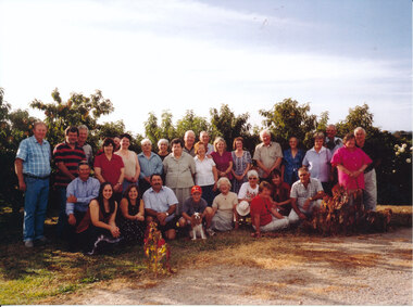
Photograph (Item) - Colour, Wonga Park: Gatters Road farewell to Colella and Buceto families as they left the orchard
... Frank and Esma Barr had an orchard on the south (uphill... an orchard on the south (uphill) side of Gatters Road ...Frank and Esma Barr had an orchard on the south (uphill) side of Gatters Road and the Colellas had an orchard on the other side of Gatters Road Frank Barr is sixth from right in back row in photo Esma Barr is fifth from right in front row in photo Sue Couper is fourth from right in front row in photo