Showing 459 items matching "subdivision map"
-
 Ringwood and District Historical Society
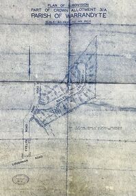
Map - Plan of Subdivision, Part of Crown Allotment 31A, Parish of Warrandyte - (Undated)
... - (Undated) Map Plan of Subdivision ...Facsimile blueprint copy of 24 residential allotments with property dimensions in Bailey Crescent (later Gabriella Court) and McEwan Street (later Suzanne Court) off Park Road and Evelyn Road, Ringwood North. Attached photocopy of undated map of allotment on south-east corner of Evelyn and Park Roads.Rubber stamp impression - J. Horne, Licensed Surveyor, 458 Nepean Highway, Frankston 31736. -
 Ringwood and District Historical Society
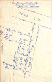
Map - Subdivision Plan, Part of Crown Allotment 39, Parish of Ringwood, County of Mornington, Heathmont, Victoria - (Undated - circa 1950s)
... - circa 1950s) Map Subdivision Plan ...Hand-drawn map on light cardboard backing showing location and size of 6 allotments on western side of Armstrong Road near Canterbury Road, Heathmont. -
 Ringwood and District Historical Society
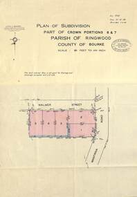
Map - Plan of Subdivision, Part of Crown Portions 6 & 7, Parish of Ringwood, County of Bourke - 1960
... of Bourke - 1960 Map Plan of Subdivision ...Copy of land title map on light cardboard backing showing layout and size of 5 residential allotments in Walmer Street and Wantirna Road, Ringwood, Victoria.Ref. 3725 Date 15-8-1960 Amended 7-9-1960. Little & Brosnan, Licensed Surveyors & Engineers, 422 Little Collins Street, Melbourne. Telephone MU 5111. -
 Ringwood and District Historical Society
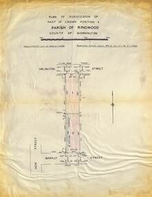
Map - Plan of Subdivision, Part of Crown Portions 6 Parish of Ringwood, County of Mornington - (Undated, circa 1950s)
... - (Undated, circa 1950s) Map Plan of Subdivision ...Copy of land title map on light cardboard backing showing layout and imperial sizes of 2 residential allotments in Arlington Street and Barkly Street, Ringwood, Victoria. -
 Bendigo Historical Society Inc.
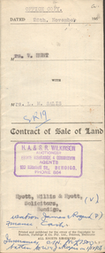
Document - H.A. & S.R. WILKINSON COLLECTION: CONTRACT OF SALE
This business was owned by father and son, Henry Archibald Wilkinson and Samuel Ronald "Ron" Wilkinson. Henry (1882-1954) was born in Shepparton and died in Bendigo. He was married to Grace Hovendon in 1908. Samuel Ronald "Ron" (1914-1995), Henry's son, was married to Florence Jean McKerlie in 1937.Contract of sale of land dated 28th November, 1958 between Mrs. V. Hunt (seller) and Mrs. L.M. Salis (buyer). Solicitor for vendor: Messrs. Hyett, Willis & Hyett, Bull Street, Bendigo. Solicitor for purchaser: Messrs. Watson, James & Rogers, Bull Street, Bendigo. For so much and such parts as lie above the depth of fifty feet below the surface of land being lot 1 on the vendor plan of subdivision situate at the corner of Victoria and Prout Streets, Bendigo part of allotment 420A section K land being delineated and colored red, blue and brown on the map in the margin hereof, together with all buildings thereon and with all floor coverings, internal and external blinds, curtains and electric light fittings and shades. Price 2,000 pounds.organization, business, h.a. & s.r wilkinson real estate -
 Ringwood and District Historical Society
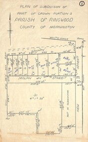
Map, Plan of Subdivision - Part of Crown Portion 3, Parish of Ringwood, County of Mornington (Undated, circa 1930s)
Hand-drawn map of subdivided allotments in Molan Street and New Street Ringwood, south of railway line.Real estate sales notations on some allotments possibly added post decimal currency changeover date, 1966. Weatherboard shop marked on south-west corner of New Street and Whitehorse Road. -
 Ringwood and District Historical Society
Map - Plan of Subdivision, Part of Crown Allotment 40B, Parish of Ringwood, County of Mornington - 1965
... , County of Mornington - 1965 Map Plan of Subdivision ...Map showing residential allotments numbered 1 to 5 on Heathmont Road and The Greenway, Heathmont, Victoria.Ref. 2937A Date 19 July 1965. Kirkpatrick & Webber, Licensed Surveyors, Civil Engineers & Town Planners, Maroondah Highway, Ringwood Telephone 870 0321. -
 Ringwood and District Historical Society
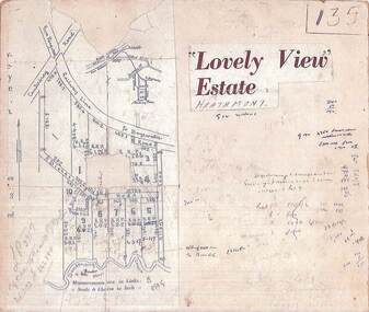
Map, Plan of Subdivision - Lovely View Estate, Heathmont, Victoria (Undated, circa 1930s)
Photocopied map from land sale brochure with handwritten real estate sales notations. Subdivision includes allotments on Dickason's Road and Allen's Road, Heathmont.LP3917 Part of Crown Allotments 14A-40A Parish of Ringwood. Vol 3232 Fol 626380. -
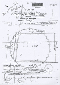 Eltham District Historical Society Inc
Document - Photocopy, Survey Field Notes of Part of Crown Portion 13, Section 4 at Eltham, Part of Lot 19 Subdivision of 13 Section IV (Holloways), Parish of Nillumbik, County of Evelyn, 5 May 1906
Portion of land bounded by: Main Road, Henry Street Application 35953 A. Mackensie Tyers, Licensed Surveyor, 5 May 1906map, neil webster collection, survey plan, surveyor field notes, 1906, application 33777, application 35953, henry street, main road eltham, maria street, rechabite hall* -
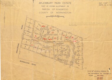 Ringwood and District Historical Society
Map - Plan of Subdivision, Aylesbury Park Estate, Part of Crown Allotment 39, Parish of Ringwood, County of Mornington - 1970
... of Ringwood, County of Mornington - 1970. Map Plan of Subdivision ...Map showing residential allotments for sale in Armstrong Road, Danielle Crescent and Locksley Close, Heathmont, Victoria.Ref.532A Date 13.4.70. Paul Millar & Associates, Land & Engineering Surveyors, 14A Main Street Croydon (Phone) 723 4493. Ref.532A Date 13.4.70. (Agent) H.G. McLean & Assoc P/L, 166 Canterbury Road Heathmont, Phone 8703422 A.H. 8706726 8700112. -
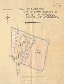 Ringwood and District Historical Society
Map - Plan of Subdivision, Part of Crown Allotment 39, Parish of Ringwood, County of Mornington - 1968
... Date 23.1.68 Amended 12.3.68 & 1.12.71. Map showing residential ...Map showing residential allotments numbered 1 to 14 Headline Court, Heathmont, Victoria, off Bronaldi Street and Yallamba Place. Adjoining lot 15 marked as 2 acres 3 roods 29.8 perches with house and garage.Paul Millar & Associates, Land & Engineering Surveyors, First Floor, 14A Main Street Croydon (Phone) 723 4493. Ref. 232B Date 23.1.68 Amended 12.3.68 & 1.12.71. -
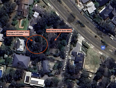 Eltham District Historical Society Inc
Document - Property Binder, 338 Main Road, Lower Plenty (also 37 Rangeview Road), March 2025
EDHS_03095-338 | EDHS_08635-37 338 Main Road Lower Plenty | 37 Rangeview Road, Lower Plenty Original Mudbrick cottage and studio designed and built by Eltham artist, David Alan Newbury See also EDHS_06090 David Newbury (Artist) David Newbury was married to Clare Margaret Newbury. According to the 1954 Electoral Roll they were living at 36A Murphy Street, South Yarra however around 1953 they purchased Lots 3 and 4 of Main Road Lot Plan LP 23911 in Lower Plenty. A building permit, No. 71, was issued 8 December 1953 for a 5-room house of Vertical Board construction, cost £2,840, builder L. Williams, owner D. Newbury of 36 Murphy Cl., South Yarra. The large house was in fact mostly built of mudbrick, the construction method was only just becoming recognised as an acceptable form in the late 1940s for issuance of a building permit. The house was commenced in 1954, designed by David Newbury and built by David Newbury, Horrie Judd and others. Information from Newbury family friends suggests that a second mudbrick building was constructed in the late 1950s, early 1960s for use as an artist studio by Newbury. The building was connected directly to the water mains at the time and was made suitable for living accommodation during the period Newbury was teaching at Bendigo. Apparently he and Claire rented out the main house during their time in Bendigo and would reside in the studio when visiting Melbourne. No permit for this studio was found in the Building Permit Register, Shire of Eltham, 1949-1960. The last recorded entries in the register are dated May 1960. This would suggest that the studio was constructed post May 1960. It is believed the studio was constructed during the latter period of Newbury’s teaching post in Bendigo so possibly late 1960/1961. In 1963 the Newbury’s address in the Electoral Roll has the property recorded as 220 Main Road, Lower Plenty. Between 1967 to 1980 the Electoral Rolls record the property as 338 Main Road. Today the address is 37 Rangeview Road, Lower Plenty. Contents: 1. Extract from 1942 Shire of Eltham Rate Book. Muriel Gladys Reitsma listed as owner 2. Extract from 1984-85 Shire of Eltham Rate Book for Rangeview Road. (No mention of No. 37 so was probably still listed as 338 Main Road.) 3. Certificate of Title, Vol. 5601 Fol. 1120089 - Issued to David James Graham of Lower Plenty, Builder, Heidelberg for Lot 32 Block B on Plan of Subdivision No. 7606, part of Crown Portion Two, Parish of Nillumbik, County of Evelyn, 29 October 1929 4. Certificate of Title, Vol. 8008 Fol. 076 - Issued to David Alan Newbury of 36 Murphy Street, South Yarra, School Teacher for Lot 3 on Plan of Subdivision No. 23911, part of Crown Portion Two, Parish of Nillumbik, County of Evelyn, 29 October 1953. Amended 24 June 1963 to transfer portion for road widening scheme per Country Roads Board Plan 6889 - Cancelled 24 September 1984 5. Certificate of Title, Vol. 9581 Fol. 583 - Issued to Paul Robert Biber and Althea Constance Biber of 139 Lower Heidelberg Road, Ivanhoe for Lot 3 on Plan of Subdivision No. 23911, part of Crown Portion Two, Parish of Nillumbik, County of Evelyn, 24 September 1984. Derived from Vol. 8008 Fol. 076 L276994V - Cancelled 20 Nov 1992 when subdivided from one to two lots in Vol 10092 Fol. 192 and Vol. 10092 Fol. 193; LP222467B 6. Certificate of Title, Vol. 10092 Fol. 192 - Transfer to Lawrie Mein of 20 Dewar Drive, Hurstbridge of Lot 1 on Plan of Subdivision No. 222467B, lodged 17 Feb 1993, Registered 29 March 1996. Parent Titles Vol 08008 Fol 077, Vol 09581 Fol 583 7. Survey Field Notes of Part of Crown Portion 2, Parish of Nillumbik, County of Evelyn - Portion of land bounded by New Eltham Road. Application 23911 dated 8 Sep 1952 with appended Surveyor Field notes per Application 7098; R.D. Steele, Licensed Surveyor, 18 August 1950 8. Survey Field Notes of Part of Crown Portion 2, Parish of Nillumbik, County of Evelyn - Portion of land bounded by Main Road and Rangeview Road; 2 Lot subdivisions, Vol. 9581 Fol. 583 Part Lot 3 on LP 23911 and Vol. 8008 Fol, 077 Lot 4 on LP 23911; Application 221805 dated 27 November 1989; W.J. Goodison, Licensed Surveyor, and attached Surveyor's Report dated 6 June 1990 (Withdrawn) 9. Survey Field Notes of Part of Crown Portion 2, Parish of Nillumbik, County of Evelyn - Portion of land bounded by Main Road and Rangeview Road; 2 Lot subdivisions, Vol. 9581 Fol. 583 Part Lot 3 on LP 23911 and Vol. 8008 Fol, 077 Lot 4 on LP 23911; Application 222467 dated 20 November 1992 (221805 resubmitted); W.J. Goodison, Licensed Surveyor, and attached Surveyor's Report dated 6 June 1990 Notes: Items 1 to 6 donated electronically Items 7 to 9 sourced from LASSI - SPEAR, Department of Transport and Planning, Victoria State Government, https://maps.land.vic.gov.au/lassi/SpearUI.jsp main road, property, mudbrick, david newbury, phoebe mason collection, rate books, shire of eltham, certificate of title, survey plan, 37 rangeview road, 338 main road, application 23911, lower plenty, map, surveyor field notes, application 221805, application 222467 -
 Ringwood and District Historical Society
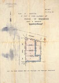
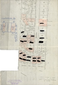
Document, Map showing numbered subdivision allotments with hand-written notations and redactions - 1924
... Map showing numbered subdivision allotments with hand...Map by Arnold Wilson & Associates, Engineers & Surveyors ...Foolscap size page Map by Arnold Wilson & Associates, Engineers & Surveyors, 399 St.Kilda Road, Melbourne, Tel 26-1840 - 1924/4. Subdivision includes Ilford Road, Karen Court, Washusen Road and Dirkala Avenue, Heathmont. Also includes hand-drawn allotments on Canterbury Road and Balfour Avenue. Page rubber-stamped by building company A & C Jaworski, Office 2, 23 Ringwood Street, Ringwood 3134, Tel 870-0820, A.H. 870-2062. -
 Ringwood and District Historical Society
Document - Map, Plan of Subdivision - Part of Crown Allotments 14A & 14C, Parish of Ringwood, County of Mornington, Vol 5378 Fol 511 - 1927
Department of Lands and Survey photocopy dated 17/1/1951, page number 12308.Map includes Canterbury Road, Heathmont Road, Dickasons Road, Bennett Avenue, Orchid Street and Allens Road, Heathmont, Vic. -
 Ringwood and District Historical Society
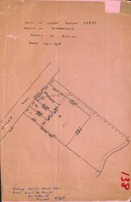
Document, Plan of Subdivision - Part of Crown Portion 5, Parish of Ringwood, County of Bourke - (Undated)
Map showing layout of 4 numbered allotments coloured red and land coloured blue appropriated or set aside for drainage and sewerage puposes.Map includes Nelson Street and Ringwood Street, Ringwood, Vic. -
 Colac RSL Sub Branch
Work on paper - Baulch Collection, Soldier Settlement Documentation. Lot 21 - Minjah Estate
... Settlement Commission dated 19/10/1955 - Map of Minjah Estate - Map... - Map of Minjah Estate - Map showing the subdivision of Minjah ...Historic documentsA4 x3 printed sheets:- - Covering letter from the Soldier Settlement Commission dated 19/10/1955 - Map of Minjah Estate - Map showing the subdivision of Minjah Estate1 x typed letter 2 x copies of mapssoldier settlement allocations -
 Ringwood and District Historical Society
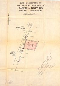
Document, Plan of Subdivision - Part of Crown Allotment 26A, Parish of Ringwood, County of Mornington - Circa 1961
Map showing layout of 2 allotments coloured red in Velma Grove, adjacent to Valda Avenue and Mirabel Avenue, Ringwood East, Vic.Handwritten notation dated 29/8/1961 by Alf King, Licensed Surveyor, 14 Grace Street, Mont Albert (Phone) WX2020 regarding plans being forwarded to Council for inspection visit. -
 Ringwood and District Historical Society
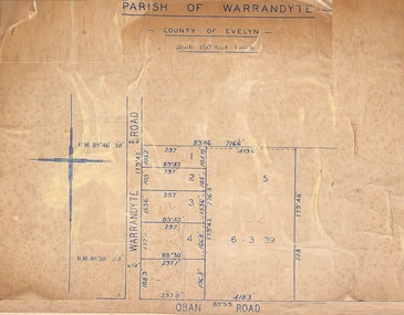
Map, Subdivision Plan of 5 residential allotments on Warrandyte Road and Oban Road, Ringwood, Victoria - (Undated - pre 1950s)
... of Crown Allotment Map on cardboard backing Subdivision Plan of 5 ...Partial copy of Crown Allotment Map on cardboard backingParish of Warrandyte, County of Evelyn. -
 Ringwood and District Historical Society
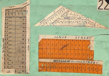
Card, Subdivision Maps - Ringwood, Victoria - (Undated, circa 1920s)
... cardboard backing. Subdivision Maps - Ringwood, Victoria - (Undated ...Collage of three residential allotment maps on green cardboard backing.Subdivisions include West Prussia Road, Wantirna Road, Station Street, James Street, Bedford Road, Williams Grove (later Lena Grove), and William Street (later Kendall Street), Ringwood. -
 Ringwood and District Historical Society
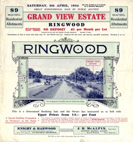
Flyer, Subdivisional Land Auction Sale Brochure, Grand Central Estate, Ringwood, Vic. - 1924
Refer also to Reg. No. 5148 for 1925 auction sale of land also titled Grand View Estate situated further south in Ringwood.Double sided multi-folded page advertising public auction sale on Saturday, 5th April, 1924, of residential allotments highlighting local facilities, services and layout of the estate. Includes panoramic view over the estate and other local photographic images. Additional clipped copy of subdivison map on blue cardboard backing includes real estate sales notations.Subdivision includes Whitehorse Road, Rupert Street, Herbert Street. and Leonard Street. Agents - Knight & Harwood, 315 Collins Street, Melbourne, Phone 10615, 10616 Central, in conjunction with J.B. McAlpin, Opposite Railway Station, Ringwood. Phone Ringwood 7. -
 Ringwood and District Historical Society
Map - Plan of Subdivision, Part of Crown Portion 7, Parish of Ringwood, County of Mornington - circa 1950
... . Map Plan of Subdivision ...Hand-drawn map attached to light cardboard backing showing 5 residential allotments on eastern side of Maidstone Street Ringwood, north of Canterbury Road.RFK 8/11/51 -
 Ringwood and District Historical Society
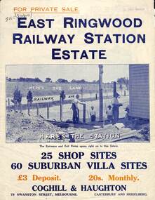
Flyer, Land Sale Brochure, East Ringwood Station Estate - c.1925
Multi-fold double sided sheet with yellow and blue print and blue monotone photographs advertising private sale of retail and residential sites. Brochure includes price list, and details of subdivision features and local facilities, with photographs. Additional clipped map of Estate on cardboard backing with handwritten sales notations and title ref LP11245.Subdivision includes Railway Avenue, Dublin Road, Lawrence Grove, Stanley Avenue. Agents - Coghill & Haughton, 79 Swanston Street, Melbourne, Phone Central 2793. Photographs include construction of East Ringwood Railway Station, "The Dive" where aquatic sports are held, Old East Ringwood Township, Davey's Hill. -
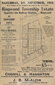 Ringwood and District Historical Society
Flyer, Auction Sale Advertisements - Ringwood Township Estate, Ringwood, Victoria - 1913
Advertisements for auction sale of retail and residential blocks opposite the Ringwood Railway Station on Saturday, 8th November, 1913, showing subdivision layout, terms of sale, and summary of local features and services. Auction at 3 o'clock on the property by order of Mr. O.J. Pratt - 18 township lots, 27 villa blocks, also weatherboard butcher's shop with 5-roomed weatherboard house and good stabling, and 5-roomed new weatherboard villa. Subdivision includes Station Road (later Warrandyte Road), Pratt Street, and Whitehorse Road. Agents - Coghill & Haughton, 79 Swanston Street, Melbourne, Auburn & Canterbury, in conjunction with J.B. McAlpin, Opposite Railway Station, Ringwood. Additional 2 partially trimmed copies allotment maps on cardboard backing with handwritten sales notations. -
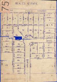 Ringwood and District Historical Society
Map, Subdivision Plan of 37 residential allotments on Panorama Avenue, Felix Crescent, Evelyn Road and Avalon Grove, Ringwood, Victoria - (Undated - circa 1960)
Stencilled copy of map on blue cardboard backingBeales Estate -
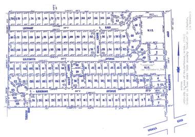 Ringwood and District Historical Society
Map, Subdivision Plan - Rosebank Avenue area, North Ringwood, Vic. - circa 1960s
Single page plan printed on green background showing allotments included in un-named subdivision layout surrounding "Rosebank" property, Warrandyte Road, Ringwood North. Subdivision includes Through Road, Rosebank Avenue, Macey Grove, Goldsmith Avenue, Dillon Grove, Lockhart Road, and Warrandyte Road.Typewritten notation against "Rosebank" property - "Mrs Godbehear, Snr.". "Goldsmith is maiden name of Mrs. Godbehear, Senior. (1960). Lockhart is town where their property "Rosebank" is situated. (In Riverina)". Additional Rosebank Avenue allotments blueprint clipping on light cardboard backing incldes handwritten title reference LP57659. -
 Ringwood and District Historical Society
Map, Subdivision Plan - 8 residential allotments south of City Road on Wantirna Road, Ringwood, Victoria - (Undated - circa 1950s)
... . (North arrow incorrectly points east.) Hand-drawn map ...Hand-drawn map on cardboard backing.Part of Crown Portion 11, Parish of Ringwood, County of Bourke. Some allotments include real estate sales notations. (North arrow incorrectly points east.) -
 Ringwood and District Historical Society
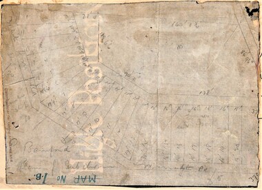
Map, Planned subdivision on White Horse Road & Warrandyte Road corner, Ringwood, Victoria - (Undated - circa 1950s)
Faded hand-drawn map on lightly transparent paper with cardboard backing. Subdivision plan for Bamford's Timber site, later varied for Safeway supermarket and subsequently part of Eastland shopping precinct by 2020s.P. Bamford -
 Ringwood and District Historical Society
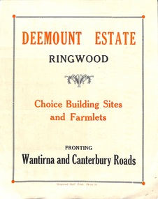
Flyer, Subdivisional Land Sale advertisement - Deemount Estate, Ringwood, Vic. - c.1950
Double sided folded page with black and orange advertisement and blueprint for Deemount Estate fronting Canterbury and Wantirna Roads, Ringwood, with handwritten price list and terms of sale. Additional undated hand-drawn map on light cardboard - 4 allotments on western side of Maidstone Street .Subdivision includes Canterbury Road, Wantirna Road and Maidstone Street. -
 Ringwood and District Historical Society
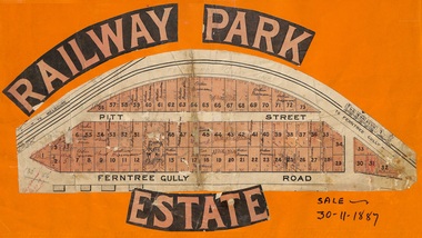
Flyer, Subdivision sale poster - Railway Park Estate, Ringwood, Victoria - 1887
Collage of clipped lettering and map pasted to orange coloured card depicting Railway Park Estate subdivision sale. Handwritten names associated with allotments and notation of sale date - 30 November, 1887. Subdivision plan with pink shading highlighting 73 allotments in Ferntree Gully Road (later Bedford Road) and Pitt Street, Ringwood. Handwritten names associated with allotments include Arthur Wiseman, T. Grant, J.J. Miller, M. Dickson, G.G. Miller, J. Frost, J.K. Turnbul, J.W. Davis, William Aldridge. Additional hand-drawn map on cardboard backing labeled Allotments for Sale at Ringwood - Part of Crown Allotment 17. -
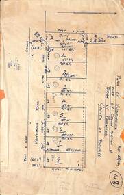
 Ringwood and District Historical Society
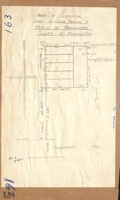
Map - Plan of Subdivision, Part of Crown Portions 32 & 33, Parish of Warrandyte, County of Evelyn - 1951
... of Warrandyte, County of Evelyn - 1951. Map Plan of Subdivision ...Map attached to light cardboard backing showing size and location of 4 residential allotments on Mullum Mullum Road Ringwood, east of Warrandyte Road.Owner - G.H.F. MacMullen 36a Mullum Road, Ringwood - 23 August 1951.