Showing 4054 items matching "surveying"
-
 St Kilda Historical Society
Photograph - Photo map, Department of Crown Lands and Survey, 22/01/1970
One of a series of photo-maps produced for the Department of Crown Lands and Survey (1857-1983). For correlation with a current map, and access to other historical photo maps of Victoria, see the Historic Photo-Maps Index published by the Department of Environment, Land, Water and Planning at https://services.land.vic.gov.au/DELWPmaps/historical-photomaps/Black and white aerial photographVic 2358 Department of Crown Lands and Survey Victoria,.© Melbourne 1970 Project Run 43E 22.1.70 5,100 ASL 208elwood, elwood beach, point ormond, elwood park, elwood canal, mc moran reserve, 1970 -
 St Kilda Historical Society
Photograph - Photo map, Department of Crown Lands and Survey, 22/01/1970
One of a series of photo-maps produced for the Department of Crown Lands and Survey (1857-1983). For correlation with a current map, and access to other historical photo maps of Victoria, see the Historic Photo-Maps Index published by the Department of Environment, Land, Water and Planning at https://services.land.vic.gov.au/DELWPmaps/historical-photomaps/Black and white aerial photographVic 2358 Department of Crown Lands and Survey Victoria,.© Melbourne 1970 Project Run 42E 22.1.70 5,100 ASL 75st kilda, st kilda beach, st kilda marina, point ormond, st kilda pier, 1970 -
 St Kilda Historical Society
Photograph - Photo map, Department of Crown Lands and Survey, 22/01/1970
One of a series of photo-maps produced for the Department of Crown Lands and Survey (1857-1983). For correlation with a current map, and access to other historical photo maps of Victoria, see the Historic Photo-Maps Index published by the Department of Environment, Land, Water and Planning at https://services.land.vic.gov.au/DELWPmaps/historical-photomaps/Black and white aerial photographVic 2358 Department of Crown Lands and Survey Victoria,.© Melbourne 1970 Project Run 41E 22.1.70 5,100 ASL 64st kilda, st kilda cemetery, balaclava, st kilda east, windsor, caulfield north, alma park, 1970 -
 St Kilda Historical Society
Photograph - Photo map, Department of Crown Lands and Survey, 08/01/1970
One of a series of photo-maps produced for the Department of Crown Lands and Survey (1857-1983). For correlation with a current map, and access to other historical photo maps of Victoria, see the Historic Photo-Maps Index published by the Department of Environment, Land, Water and Planning at https://services.land.vic.gov.au/DELWPmaps/historical-photomaps/Black and white arial photographVic 2345 Department of Crown Lands and Survey Victoria,.© Melbourne 1970 Project Run 40 8.1.70 5,100 ASL 77albert park, fawkner park, south yarra, middle park, prahran, windsor, st kilda, st kilda west, 1970 -
 St Kilda Historical Society
Photograph - Photo map, 22/01/1970
One of a series of photo-maps produced for the Department of Crown Lands and Survey (1857-1983). For correlation with a current map, and access to other historical photo maps of Victoria, see the Historic Photo-Maps Index published by the Department of Environment, Land, Water and Planning at https://services.land.vic.gov.au/DELWPmaps/historical-photomaps/Black and white aerial photographVic 2358 Department of Crown Lands and Survey Victoria,.© Melbourne 1970 Project Run 43E 22.1.70 5,100 ASL 206elwood, elsternwick, elsternwick park, 1970 -
 Otway Districts Historical Society
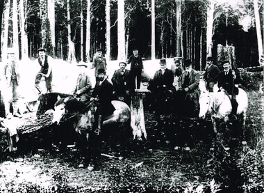
Photograph, Railway Survey Camp, Beech Forest, 4 Apr 1897, 4 April 1897
On the 18th August, 1896, the question of selecting localities for the permanent survey of a narrow-gauge line to Beech Forest from Colac was mooted. Two potential lines were examined. In a memorandum to the Minister for Railways, dated 23rd March, 1897, the Engineer-in-Chief recommended that the eastern and longer route via Lardner's Track be adopted. The second route, while identical from Colac to Gellibrand River, differed. By a more direct route the Beech Forest terminus is reached 5 miles sooner and cost approximately L24,500 less. The direct line would also serve a larger lot of settlers and would obtain a larger lot of traffic than the alternate proposal. The Parlimentary Standing Committee on Railways examined the proposal in situ and recommended that the direct route from Gellibrand to Beech Forest should be adopted and the Lardner's Track route should be abandoned at once.Photograph, Railway Survey Camp, 4 April 1897. Inspection of alternative routes by Parliamentary Committee on Railways.People named in the photograph.beech forest; railway; survey; victorian parliament; calcutt; fraser; e.h. cameron; d. mciville; a. harris; n. mcinnes; j.s. white; j. wood; t. baker; j. gardner; t.g. watson; standing committee; -
 Whitehorse Historical Society Inc.
Article, Platypuses' clean bill of health, 2004
Describes a survey of the platypus population in Mullum Mullum Creek with comparisons to previous surveys back to 1995.Describes a survey of the platypus population in Mullum Mullum Creek with comparisons to previous surveys back to 1995.Describes a survey of the platypus population in Mullum Mullum Creek with comparisons to previous surveys back to 1995.wildlife, platypuses, willis, cathy, williams, geoff, mullum mullum creek -
 Federation University Historical Collection
Map, Ballaarat Gold Field, 1861, 1861
A party of surveyors camped by Yuille's Swamp (later Lake Wendouree) and surveyed the countryside for a map to be produced by the Geological Survey of Victoria. In November 2004 the Central Highlands Regional Library presented a special edition of 200 copies of the 1861 map reproduced from a copy in their collection. Original 1861 map of Ballarat showing streets and leads. Blue dots indicate gold leads, and red lines indicate auriferous quartz reef and outcrops of quartz veins."Compiled & Drawn from the Survey of Mining Surveyors Davidson, Fitzpatrick and Cowan & the Plans in the Surveyor General's Office by J. Brahe, 21st October 1861. R. Brough Smyth, Secretary for Mines. The Honourable J.B. Humffray, M.L.A. Commr of Mines.”ballarat, map, ballarat east, lake wendouree, survey, mines, robert davidson, ballarat gold field 1861, yuille's swamp, wendouree swamp, little bendigo diggings, gold leads, old post office hill, specimen hill, bakery hill, black hill, dead horse creek, brown hill, pennyweight hill, clayton hill, soldiers hill, golden point, gum tree flat, white flat, poverty hill, chinese village, robert brough smyth, ballarat map 1861, ballaarat vineyard, dead horse gully, deadhorse creek, invermay, black hill flat, gaelic church, police reserve, magpie range, dalton's flat, caadian lead, rifle butts, powder magazine, bathing house, government camp, gold office, chinese, llanberrris, victoria theatre, charlie napier hotel, united states hotel, grape's hoel, clayton's hill, cattleyard hill, free trade hotel, esmond lead, bakery hill, black hill lead, juvenile reformatory, ballarat orphanage, lady barkly lead, triffet's slaughter yard, little bendigo, melbourne road, t. cowan, thomas cowan -
Port Melbourne Historical & Preservation Society
Document - Report, Delapidation survey on 78 Princes St, prepared by Mirvac, 25 Sep 1995
Survey undertaken prior to Beacon Cove development, in order to prevent subsequent claims of damage by householder. Residence of Hazel WILSON. Papers found in her house after her move to a nursing home..Delapidation survey report from Mirvac Victoria for the property at 78 Princes Street, issued prior to beginning development opposite. Eight colour photos of property (outside and internal views), plus one page of observations and covering letter 1995town planning, built environment - domestic, mirvac, hazel wilson nee trembath, princes street, beacon cove -
 Bendigo Military Museum
Photograph - Military Funeral, Army Headquarters Survey Regiment Personnel, Harcourt, c1960s
This is a set of 15 black & white photographs of troops from the Army Headquarters Survey Regiment, Fortuna, Bendigo undertaking ceremonial drill at a military funeral held in Harcourt circa 1960s. As a senior officer of field rank (Colonel or above) led the funeral procession, it is presumed the unknown deceased soldier was also a highly ranked field officer. It is presumed the location of the burial was Harcourt in central Victoria, based on the inscription on the pillar at the entrance to the cemetery. This is a set of 15 black & white photographs of troops from the Army Headquarters Survey Regiment, Fortuna, Bendigo undertaking ceremonial drill at a military funeral held in Harcourt circa 1960s. The photographs were printed on photographic paper and are part of the Army Survey Regiment’s Collection. The photographs were scanned at 300 dpi. .1) to .15) - Photo, black & white, c1960s. Unidentified soldiers and civilians. No inscriptions or markings. No personnel are identified.royal australian survey corps, rasvy, army survey regiment, army svy regt, fortuna, asr -
 Federation University Historical Collection
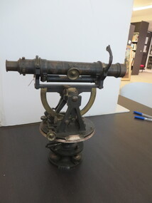
Scientific Instrument, Theodolite: Early 1900s, c1860
... surveying ...The theodolite is used in surveying and measures vertical and horizontal angles. Placed on a tripod, it is used to find angles in road building, tunnel alignment and other civil-engineering work. The theodolite was used at Ballarat School of Mines in the surveying course. It is possible that this instrument was imported by Flavelle Bros & Co having been made to their order by a European instrument makerTheodolite (without a matching tripod) with four leveling screws at the base. Telescope not fully rotatable, ends can be interchanged. Underslung levelling bubbletheodolite, surveying, european instrument, importers, ballarat school of mines, flavelle bros & co, measuring angles, road building, civil engineering -
 Bendigo Military Museum
Photograph - Royal Australian Survey Corps Personnel – School of Military Survey, Bonegilla and Army Survey Regiment, Bendigo, 1977 to 1989
This is a collection of 19 photographs of Royal Australian Survey Corps personnel taken at the School of Military Survey (SMS), Bonegilla and the Army Survey Regiment (ASR), Bendigo from 1977 to 1989. Personnel identified in photographs .1P to .6P were attending their initial employment training at the SMS. Personnel identified in the remaining photographs were posted to the ASR in the 1980s.This is a collection of 19 photographs of Royal Australian Survey Corps personnel probably taken at the School of Military Survey, Bonegilla and the Army Survey Regiment, Bendigo from 1977 to 1989. The black and white and colour photographs are printed on photographic paper and scanned at 300 dpi. They are part of the Army Survey Regiment Collection. .1) - Photo, black & white, c1977 Wolfgang Thun. .2) - Photo, black & white, c1977, Alan Wilkins. .3) - Photo, black & white, c1977, Scott Hatten. .4) - Photo, black & white, c1977, Mark Casey. .5) - Photo, black & white, c1977, Marty George. .6) - Photo, black & white, c1977, Mark Lander. .7) - Photo, black & white, c1980s, L to R: Chris ‘Charlie’ Brown, Jamie ‘Fish’ McRae. .8) - Photo, black & white, c1980s, L to R: Scott Payne, Steve Drummond. .9) - Photo, black & white, c1980s, David Murphy. .10) - Photo, black & white, c1980s, Bob Sheppard. .11) - Photo, black & white, c1980s, Lyall Camp. .12) - Photo, black & white, c1980s, Peter ‘Spoon’ Lefel. .13) - Photo, black & white, c1980s, L to R: Greg Honan, Jann (Caithness) Lambton-Young. .14) - Photo, black & white, c1980s, L to R: Brian Fauth – partially obscured, Mick Gillham, Sherri (Dally) Burke, Gordon Lowery. .15) - Photo, black & white, c1980s, Lorraine (Daly) Talbot-Smith. .16) - Photo, black & white, c1980s, Lance Strudwick. .17) - Photo, black & white, c1980s, L to R: Geunther Ebenwaldner – partially obscured, Roy Hicks. .18) - Photo, black & white, c1980s, L to R: Paul Hopes, Steve Drummond, Rob Straube. .19) - Photo, black & white, c1980s, L to R: Geunther Ebenwaldner – facing away, unidentified, Bob Thrower. .1P to .19P The are no annotations.royal australian survey corps, rasvy, army survey regiment, army svy regt, fortuna -
Whitehorse Historical Society Inc.
Newspaper, Andy goes and we lose a link with the past, 1/05/1980 12:00:00 AM
James (Andy) Blackburn, great great grandson of James Blackburn who was instrumental in providing Melbourne with its good water supply.James (Andy) Blackburn, great great grandson of James Blackburn who was instrumental in providing Melbourne with its good water supply joined the Board of Works in 1946 and will retire on 28/7/1980. He designed a slide rule, now a standard requirement for survey students.James (Andy) Blackburn, great great grandson of James Blackburn who was instrumental in providing Melbourne with its good water supply. blackburn, james, blackburn, james andrew duncan, melbourne and metropolitan board of works, mitchell, j.e., philipson, ralph, boyd, robin -
 Bendigo Military Museum
Photograph - Lithographic Squadron Personnel and Equipment, Army Survey Regiment, Fortuna, Bendigo, c1990
These 28 photographs of Lithographic Squadron personnel and equipment was taken at Fortuna, Bendigo circa 1990. The photos were taken on the east side of Fortuna Villa, the Print Room’s map trimming and dispatch work area and the inside and outside Air Survey Support Section (BARCRO).These 28 photographs of Lithographic Squadron Personnel and Equipment was taken at Fortuna, Bendigo circa 1990. The 35mm colour photograph negatives were scanned at 96 dpi and are part of the Army Survey Regiment’s Collection. .1) - Photo, colour, c1990. RAEME and maintenance support, unidentified civilian. .2) - Photo, colour, c1990. Eastern side of Fortuna Villa, unidentified, CPL Le-Anne (Smallshaw) Shirley. .3) - Photo, colour, c1990. Eastern side of Fortuna Villa, SGT Gary Kerr. .4) - Photo, colour, c1990. Eastern side of Fortuna Villa, CPL Roy Hicks. .5) - Photo, colour, c1990. Eastern side of Fortuna Villa, unidentified. .6) - Photo, colour, c1990. Unidentified passing Q-Store & Transport Compound. .7) - Photo, colour, c1990. Data Management & Map Library. .8) - Photo, colour, c1990. Unidentified officer passing Q-Store heading up to Map Library. .9) - Photo, colour, c1990. Eastern side of Fortuna Villa, SPR Michelle Withers. .10) - Photo, colour, c1990. Unidentified RAEME soldier passing Q-Store heading up to Map Library. .11) & .12) - Photo, colour, c1990. Delivery of bulk map printing paper. WO2 Jeff Willey on forklift, unidentified. .13) & .14) - Photo, colour, c1990. Print Room, Wohlenberg MCS-2 guillotine. .15) to .18) - Photo, colour, c1990. Air Survey Support Section (BARCRO), Carl Zeiss Rectifying Enlarger. .19) - Photo, colour, c1990. Air Survey Support Section (BARCRO), film contact frame. .20) - Photo, colour, c1990. Air Survey Support Section (BARCRO), Pakotone film development processors. .21) & .22) - Photo, colour, c1990. Air Survey Support Section (BARCRO) entry/exit. .23) & .24) - Photo, colour, c1990. Air Survey Support Section (BARCRO) miscellaneous equipment. .25) & .26) - Photo, colour, c1990. Air Survey Support Section (BARCRO), CPL Warren ‘Waldo’ Shirley. .27) & .28) - Photo, colour, c1990. Outside Air Survey Support Section (BARCRO), L to R: WO1 Peter Coombes, CPL Warren ‘Waldo’ Shirley..1P to .28P – There are no annotations.royal australian survey corps, rasvy, army survey regiment, army svy regt, fortuna, asr, litho sqn -
Whitehorse Historical Society Inc.
Map, Plan of the Parish of Nunawading, 1853
Photocopy of map showing names of selectors, also list of references to the corners of allotments.Photocopy of map showing names of selectors, also list of references to the corners of allotments. Note on verso:'Gardiners Creek, Ballyshanassey township surveyed by H. Parmein, Surveyor General's Office Nov 30, 1853 also Reference to the Corners of allotments' (Plan 428)Photocopy of map showing names of selectors, also list of references to the corners of allotments. land subdivision, gardiners creek, ballyshanassy, parmein, h, burwood east, maps -
 Stawell Historical Society Inc
Photograph, Ian McCann, Main Street - Gold Reef Mall, c 1987
surveying work for the mallgold reef mall -
Stawell Historical Society Inc
Map, Geological Survey of Victoria
Geological Survey of Victoriastawell -
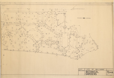 Friends of Ballarat Botanical Gardens History Group
Plan - Survey Plan A, G. Creek, City of Ballarat Botanical Gardens
HistoricSurvey map on papersurvey map, city of ballaarat, ballarat botanical gardens -
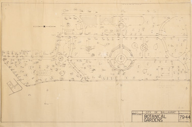 Friends of Ballarat Botanical Gardens History Group
Plan - Survey Plan A, G. Creek, City of Ballarat Botanical Gardens
HistoricSurvey map on papersurvey map, city of ballaarat, ballarat botanical gardens -
 City of Moorabbin Historical Society (Operating the Box Cottage Museum)
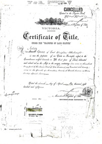
Document - Photocopy of Land Title 1881, c1881
This is a Certificate of Title for an acre of land in 'Tucker's Road' purchased by Jabez Gurr in 1881, in the area that was part of the Crown Block known as Henry Dendy's Special Survey 1841, in the Parish of Moorabbin, County of Bourke, Victoria. Following the 'Transfer of Land Statute' allotments in the area of Henry Dendy's Special Survey of 1841 were sold to early settlers. This Certificate of Title shows the passage of history in Moorabbin Shire . Jabez Gurr, a wheelwright, of East Brighton, now Bentleigh East, purchased an acre of land in 'Tucker's Road' , near Centre Road, in 1881. In 1889 he sold to a produce merchant, Robert Smith, and in April 1916 this block was purchased by William Henry George Box, a market gardener and relative of William and Elizabeth Box, who owned the land until 1926. The land was then purchased by Charles John Greenlaw Coates and remained with this family until 1971. All these Family names appear on Councils and Community Boards during the foundation and development of City of Moorabbin3 photocopied pages of the Certificate of Title for approximately 1 acre of land near the corner of Centre Road and Tucker Road, Parish of Moorabbin, County of Bourke, Victoria that was part of the 5,120 acre Henry Dendy Special Survey in Brighton in 1841 and purchased in 1881 by Jabez Gurr. It records subsequent proprietors up to 1971Stamped CANCELLED 12 OCT 1994 (top Right) / Entered in the Register Book / Vol.1245 Fol. 248877/ signed Henry Crowe / Assistant Registrar of Titles / Coat of Arms / VICTORIA / Certificate of Title / UNDER THE ' TRANSFER OF AND STATUTE' /dated ' eleventh day of April one thousand eight / hundred and eighty one' / signed 'Henry Crowe' / Assistant Registrar of Titles/ ENCUMBRANCES REFERRED TO / circular Stamp 'OFFICE OF TITLES VICTORIA' / Drawn and shaded on the left side is the area of land in "Tucker's" Road 3331/3 links fro Centre Road, 150 links x 6662/3 links / The measurements are in linksdendy henry, dendy's special survey 1841, brighton, moorabbin, bentleigh, market gardeners, early settlers, pioneers, wheelwrights, merchants, fruit gardens, markets, smith robert, box william henry george, gurr jabez, county of bourke, victoria, melbourne, land statutes, tucker road, centre road, box william, box elizabeth, box cottage museum -
 Bendigo Military Museum
Photograph - Lithographic Technician Preparing Printing Plates at the Army Survey Regiment, Fortuna Villa Bendigo, c1990s
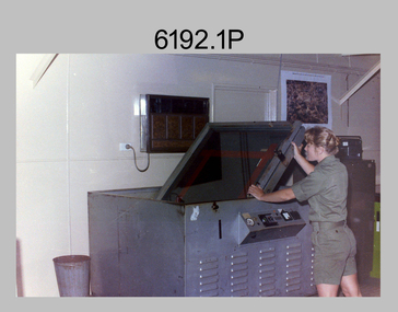
These six photographs were most likely taken from the 1960s to the 1980s in Lithographic Squadron at the Army Survey Regiment, Fortuna, Bendigo. In photos .1P to .6P the Printing Technician is placing a map film negative on top of the printing plate within a vacuum frame before light exposure. See items 6060.8P and 6191.11P for more photos and information on printing plate processing.This is a set of six photographs of lithographic technicians preparing printing plates at the Army Survey Regiment, Bendigo c1990s. The photographs were on 35mm negative film and were scanned at 96 dpi. They are part of the Army Survey Regiment’s Collection. .1) to .4) - Photo, black & white, c1990s, SPR Janet Murray preparing a printing plate in a vacuum frame. .5) to .6) - Photo, black & white, c1990s, printing plate vacuum frame..1P to .6P – there are no annotations.royal australian survey corps, rasvy, army survey regiment, army svy regt, fortuna, asr, litho -
 Kew Historical Society Inc
Photograph - Historic re-enactment during the Festival of Kew, 1978
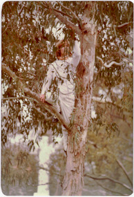
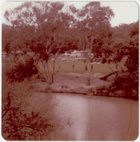
At the 1978 Festival of Kew, a number of organisations, including the City of Kew, the Kew Historical Society, Trinity Boys Grammar School and local Girl Guides participated in a re-enactment of the expedition of the party of Charles Grimes in surveying the Yarra River as far as Kew in February 1803. The location for the event was Yarra Bend Park near the Studley Park Boat House. The event was organised by the Kew Historical Society. The re-enactment was captured by a number of amateur photographers as well as by a photographer from the local Progress Press.Local communities select events to commemorate according to their shared history and values. Commemorations of colonial exploration were popular with local historical groups such as the Kew Historical Society in the twentieth century. In re-enacting events such as the Grimes survey of the Yarra, students from a local school were encouraged to take on specific roles, including play-acting individuals involved in the survey party as well as members of the local Wurundjeri People. The photographs, taken by amateur and professional photographers, represent a period in time when the dominant values were those shared by the descendants of European settlers in Victoria. Original colour photographic positive showing a boy from Trinity Grammar School in a tree, role-playing Captain Robbins, a member of Grimes' survey party.Annotated on reverse: "CAPTAIN ROBBINS LOOKING UP THE YARRA AND REPORTING: 'A LAND THAT OFFERS GREAT OPPORTUNITY FOR SETTLEMENT' / RE-ENACTED BY A TRINITY BOY / 1978 FESTIVAL"kew historical society, trinity grammar school, kew girl guides, city of kew, yarra river, charles grimes, collins expedition, wurundjeri people, yarra bend park, colonial surveys, historic re-enactments, festival of kew, kew festival -
 Kew Historical Society Inc
Photograph - Historic re-enactment during the Festival of Kew, 1978
At the 1978 Festival of Kew, a number of organisations, including the City of Kew, the Kew Historical Society, Trinity Boys Grammar School and local Girl Guides participated in a re-enactment of the expedition of the party of Charles Grimes in surveying the Yarra River as far as Kew in February 1803. The location for the event was Yarra Bend Park near the Studley Park Boat House. The event was organised by the Kew Historical Society. The re-enactment was captured by a number of amateur photographers as well as by a photographer from the local Progress Press.Local communities select events to commemorate according to their shared history and values. Commemorations of colonial exploration were popular with local historical groups such as the Kew Historical Society in the twentieth century. In re-enacting events such as the Grimes survey of the Yarra, students from a local school were encouraged to take on specific roles, including play-acting individuals involved in the survey party as well as members of the local Wurundjeri People. The photographs, taken by amateur and professional photographers, represent a period in time when the dominant values were those shared by the descendants of European settlers in Victoria. Original colour photographic positive of the site where the re-enactment of Charles Grimes' survey party of 1803 took place during the Kew Festival of 1978.Annotated on reverse: "GRIMES LANDING SITE / 1978 / DONATED BY MRS DEAN"kew historical society, trinity grammar school, kew girl guides, city of kew, yarra river, charles grimes, collins expedition, wurundjeri people, yarra bend park, colonial surveys, historic re-enactments, festival of kew, kew festival -
Lakes Entrance Historical Society
Book, Morrissey, D.W and Morrissey E.W, Lakes Entrance a Short History revised Edition, 1980
History of Koorie inhabitants through to fishing industry, timber industry, early settlers and survey and sale of land. The opening of the entrance to allow shipping industry to operate bringing much trade and movement of primary produce etc. Local schoolHistory of Koorie inhabitants through to fishing industry, timber industry, early settlers and survey and sale of land. The opening of the entrance to allow shipping industry to operate bringing much trade and movement of primary produce etc. Local schoolMargaret Campbell''land settlement, religion, aboriginals -
 St Kilda Historical Society
Photograph - Photo map, Department of Crown Lands and Survey, 22/01/1970
One of a series of photo-maps produced for the Department of Crown Lands and Survey (1857-1983). For correlation with a current map, and access to other historical photo maps of Victoria, see the Historic Photo-Maps Index published by the Department of Environment, Land, Water and Planning at https://services.land.vic.gov.au/DELWPmaps/historical-photomaps/Black and white aerial photographCONTROLLED Vic 2358 Department of Crown Lands and Survey Victoria,.© Melbourne 1970 Project Run 41E 22.1.70 5,100 ASL 66st kilda, albert park, st kilda west, catani gardens, st kilda botanical gardens, st kilda pier, st kilda beach, 1970 -
Whitehorse Historical Society Inc.
Map, Parish of Nunawading, 1853
Photocopy of manuscript map with allotments numbered and named.Photocopy of manuscript map with allotments numbered and named. Note on verso: Parish of Nunawading, County of Bourke. Gardiners Creek, Ballyshanassey Township, surveyed by H. Parmein, Surveyor General's office, Nov 30th 1853 [enlargement of ND2801, no list of corner references]Photocopy of manuscript map with allotments numbered and named. maps, gardiners creek, ballyshanassy, burwood east, parmein, h -
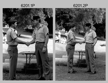 Bendigo Military Museum
Photograph - Army Survey Regiment - Defence Force Service Medal Presentations, Fortuna Villa, Bendigo, 1992
These five photographs were taken at a formal Army Survey Regiment medal presentation at the lakeside of Fortuna on the 11th of December 1992. The CO of the Army Survey Regiment – LTCOL Bob McHenry presented the Defence Force Service Medal to five RA Svy personnel in recognition of 15 years of efficient remunerated service. They were SSGT Greg Byers, SGT Peter Hardy, SGT Garry Kerr, SGT Laurie Justin and WO2 Rhys De Laine. LTCOL Bob McHenry was the CO of the Army Survey Regiment from 1992 to 1993.These five black & white photographs were taken at a Defence Force Service Medal Presentation on the 11th of December 1992 at the Army Survey Regiment, Bendigo. The photographs were printed on photographic paper and are part of the Army Survey Regiment’s Collection. The photographs were scanned at 300 dpi. .1) Photo, black & white, L to R: SSGT Greg Byers and LTCOL Bob McHenry. .2) Photo, black & white, L to R: SGT Peter Hardy and LTCOL Bob McHenry. .3) Photo, black & white, L to R: SGT Garry Kerr and LTCOL Bob McHenry. .4) Photo, black & white, L to R: SGT Laurie Justin and LTCOL Bob McHenry. .5) Photo, black & white, L to R: WO2 Rhys De Laine and LTCOL Bob McHenry..1 to. 5P – annotations identifying personnel and the date provided on paper.royal australian survey corps, rasvy, army survey regiment, army svy regt, fortuna, asr -
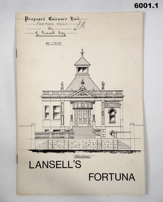 Bendigo Military Museum
Booklet - Lansell's Fortuna, Army Survey Regiment, Circa 1960
History of Fortuna Villa covering owners and occupiers, the building and the tour during Army tenure. Mentions original owner Christopher Balderstedt, George Lansell and Royal Australian Survey Corps tenures. A number of different versions of this booklet were produced. Each version had a different colour cover. This orange covered edition was the last version produced and printed.6001.1 The white covered version is the first edition of the Fortuna Tour booklet. 6001.2 The orange and off-white covered booklet is the final edition of the Fortuna Tour booklet produced by the Army Survey Regiment, 36 pages, contains black and white photos, colour photos, plans, sketches, maps, diagrams, gloss paper, stapled spline 20cm x 29cm 6001.3 The green covered edition is a second variation of the Army Survey Regiment Tour Bookletroyal australian survey corps, rasvy, fortuna, army survey regiment, army svy regt, asr -
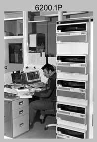 Bendigo Military Museum
Photograph - AUTOMAP 1 Production – Army Survey Regiment, Fortuna, Bendigo, c1980
This collection of five photos was most likely taken in c1980. The AUTOMAP 1 computer assisted cartography and mapping system was introduced in 1975. The components of AUTOMAP 1 were the Input Sub-System of four Wild B8s stereoplotters and three Gradicon digitising tables, the Optical Line Following Sub-System – Gerber OLF, the Verification Sub-System – Gerber 1442 drum plotter, the General Purpose Sub-system – HP21MX computer and the Output Sub-System – Gerber 1232 flatbed plotter). The first map was published in 1978 (Strickland 3665-3, 1:50,000). AUTOMAP 1 was the first computer assisted cartography and mapping system utilised by the Survey Corps and was the first system used by Australian mapping organisations. The history of the AUTOMAP 1 system is covered in more detail with additional historic photographs, in pages 116-118 of Valerie Lovejoy’s book 'Mapmakers of Fortuna – A history of the Army Survey Regiment’ ISBN: 0-646-42120-4. See items 6410.24P, 6122.20P, 6183.19P, 6184.20P and 6222.17P for more photos of the AUTOMAP 1 computer system.This is a set of five photographs of Air Survey Squadron military personnel operating AUTOMAP 1 equipment at the Army Survey Regiment at Fortuna, Bendigo, c1980. Black and white photos are on photographic paper and were scanned at 300 dpi. They are part of the Army Survey Regiment’s Collection. .1) - Photo, black & white, c1980, SGT Cliff Webb operating AUTOMAP 1 terminal. .2) - Photo, black & white, c1980, HP21MX computer General Purpose Sub-system. .3) - Photo, black & white, c1980, Gerber verification drum plotter. .4) and .5) - Photo, black & white, c1980, unidentified personnel operating AUTOMAP 1 terminal. .1P to .5P - No personnel are identified.royal australian survey corps, rasvy, army survey regiment, army svy regt, fortuna, asr, automap 1 -
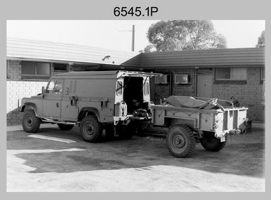 Bendigo Military Museum
Photograph - 4th Field Survey Squadron - Land Rover Perentie Light Vehicles in the Field, 1987
This is a set of nine photographs featuring 4th Field Survey Squadron’s newly introduced Survey variant of the Land Rover Perentie light truck vehicle on a field trip in SA, in 1987. The Land Rover Perentie is a nickname for the Land Rover 110 produced by JRA Limited for the Australian Army, and part manufactured and assembled in Moorebank, New South Wales, during the 1980s and 1990s The name Perentie originates from Land Rover's successful tender to Project Perentie, which was the official Australian Army trial to select new 1 and 2-tonne light vehicles to replace the ageing fleet of Series 2A and 3 Land Rovers. The major differences between the Land Rover Perentie and British Land Rovers were the relocation of the spare wheel to a position under the rear of the load area, a galvanised chassis and the Isuzu engine. The Land Rover Perenties were produced in 4x4 and 6x6 variants and powered by an Isuzu 3.9-litre four-cylinder 4BD1 diesel engine. The Truck, Panel, Lightweight, Survey, FFR, Winch, MC2 model was one of eight 4x4 variants built for the Australian Army. There were 35 Vehicles built to satisfy the operational requirements of RA Svy’s units. Source – Wikipedia. See item 6544.35P for related photos of these vehicles.This is a set of 35 photographs featuring 4th Field Survey Squadron’s newly introduced Survey variant of the Land Rover Perentie light truck vehicle, at Keswick Barracks, Adelaide SA in 1987. The black & white photograThis is a set of nine photographs featuring 4th Field Survey Squadron’s newly introduced Survey variant of the Land Rover Perentie light truck vehicle on a field trip in SA, in 1987. The black & white photographs are on 35mm negative film and are part of the Army Survey Regiment’s Collection. The photographs were scanned at 96 dpi. .1) - Photo, black & white, 1987. Perentie Land Rover with trailer parked outside unknown motel in SA. .2) & .3) - Photo, black & white, 1987. Field trip featuring Perentie Land Rover. .4) - Photo, black & white, 1987. Field trip featuring Perentie Land Rover. Series 3 Land Rover parked behind. Unidentified personnel. .5) & .6) - Photo, black & white, 1987. Field trip featuring Perentie Land Rover. Unidentified personnel. .7) & .8) - Photo, black & white, 1987. Field trip featuring Perentie Land Rover. Typical sandy 4WD track on fence line. .9) - Photo, black & white, 1987. Field trip featuring Perentie Land Rover. Probable gas extraction facility..1P to .9P – There are no personnel identified. ‘PERENTI MOTOR VEHICLES JUL 87’ annotated on negatives sleeve.tified. royal australian survey corps, rasvy, 4 fd svy sqn