Showing 621 items
matching william box
-
 Ballarat Heritage Services
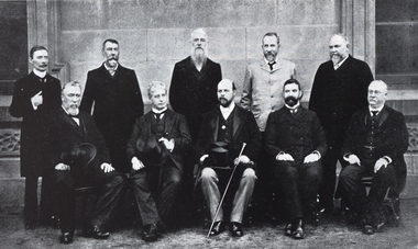
Photograph - Image, First Australian Federal Cabinet, 1901
Australia became a federation of States in 1901.Ten men of the first Australian Federal Cabinet Standing left to right: J.G. Drake, R.E. O'Connor, Sir P.O. Fysh, C.C. Kingston, Sir John Forrest. Seater left to right: Sir Wiliam Lyne, Prime Minister Edmund Barton, Governor-General Lord Tennyson. Alfred Deakin, Sir George Turner. j.g. drake, r.e. o'connor, sir p.o. fysh, c.c. kingston, sir john forrest., prime minister edmund barton, sir george turner., afred deakin, lord tennyson, william lyne -
 Ballarat Heritage Services
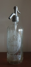
Domestic object - Soda Syphon, Joe's Soda Water Syphon
James Lawrence opened The South Gippsland Cordial Co. in Mine Rd, Korumburra, in 1895. It passed through a number of hands in the first half of the 20th century, from William Dobell to Mr Ebsworth, then finally to Colin Malcolm McLean in 1946. McLean dropped what he considered to be the old fashioned Lyrebird label, and in 1948 introduced the new, modern “Joe’s” label.Glass botte with metal soda syphon. The glass is etched with "Joe's Soda Water, South Gippsland Cordial Co Korumburra. This syphon remains the property of South Gippsland Cordial Co, Kurumburra and its use by others is illegal."joe's soda water, south gippsland cordial co. korumburra, soda syphon -
 Ballarat Heritage Services
Domestic object - Soda Syphon, Joe's Soda Water Syphon, c1950
James Lawrence opened The South Gippsland Cordial Co. in Mine Rd, Korumburra, in 1895. It passed through a number of hands in the first half of the 20th century, from William Dobell to Mr Ebsworth, then finally to Colin Malcolm McLean in 1946. McLean dropped what he considered to be the old fashioned Lyrebird label, and in 1948 introduced the new, modern “Joe’s” label.Glass botte with metal soda syphon. The glass is etched with "Joe's Soda Water, South Gippsland Cordial Co Korumburra. Net contents 30.FL.OZS This syphon remains the property of South Gippsland Cordial Co, Kurumburra and its use by others is illegal. British Syphon Company"joe's soda water, south gippsland cordial co. korumburra, soda syphon -
 Ballarat Heritage Services
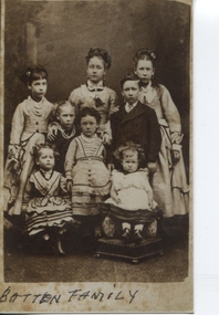
Photograph - Black and White, Batten Family, 1870+
Children of William Henry Batten L to R back: Lucy Alice, Anne, Florence Ellen Centre: Agnes, Margaret, Robert (Their mother Anna Maria Brommell died 1869) Sitting: Sarah Amy, Mabel Jessie (mother Kate Taylor - 9 more children came later)Photograph sepiaBATTEN FAMILY verso "2"william batten, william henry batten, lucy batten, anne batten, florence batten, agnes batten, anna batten, anna brommell, mabel batten -
 Ballarat Heritage Services
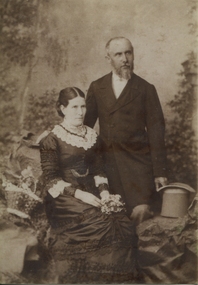
Photograph - Photograph - Black and White, William Henry Batten and second wife Kate Taylor, 1870+
William Henry Batten and Kate Taylor were married Church of England Buninyong on 1 October 1870.Black and white photograph of William Henry Batten and second wife Kate Taylor.verso 1/william batten, kate taylor, kate batten -
 Ballarat Heritage Services
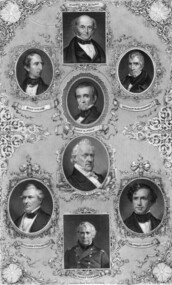
Image, Cameo portraits of Eminent Americans, 1857, 1857
Black and white portraits of eminent Americans.america, martin van buren, john tyler, james k. polk, william h. harrison, james buchanan, millard fillmore, zachary taylor, franklin pierce -
 Ballarat Heritage Services
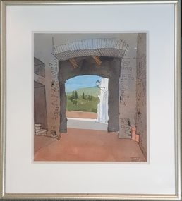
Painting - Artwork - painting, William Gribble, "Medieval Alleyway, Perugia, Italy" by William Gribble
Photograph of a framed pen and water colour painting of a scene in Italy.william gribble, bill gribble, perugia, italy, artwork, watercolour -
 Ballarat Heritage Services
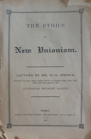
Booklet, William Guthrie Spence, The Ethics of New Unionism, 1892, 1892
Ten page booklet of a lecture given by William Guthrie Spence. -
 Ballarat Heritage Services
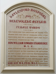
Photograph - Photograph - colour, Clare Gervasoni, Daylesford Hospital Benevolent Asylum Memorial Plaque for Female Wards, 1897, c1897
Daylesford Hospital was opened in 1862.Marble plaque on the stairwell in Daylesford Hospital.Daylesford Hospital and Benevolent Asylum Female Wards The funds for the erection of these two wards for the use of females only were provided out of a legacy left for that especial purpose by the Hon. William Edward Stanbridge M.L.C. who departed thislife 5th April 1894 after residence in the district of upwards of 40 years and having represented it in the Legislative Council from the 15th December 1881 to the 26rh August 1892 opened on the 26th May 1897 by the Hon Sir W.A. Zeal M.L.C. President of the Legislative Council of Victoria. daylesford hospital, daylesford benevolent asylum, daylesford hospital and benevolent asylum, william edward stanbridge, w.a. zeal, legislative council -
 Ballarat Heritage Services
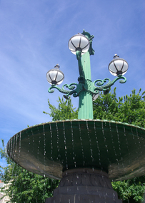
Photograph - Colour, Burke and Wills Fountain, Sturt Street Gardens, 2011, 29/12/2011
Colour photographs of the Burke and Wills Fountain in Sturt Street Balllarat.Plaque "Robert O'hara Burke, Leader. Died 30th June, 1861. William John Wills, Second. Died 30th June, 1861. Ludwig Becker, Naturalist. Died 29th April, 1861. Charles Grey, Assistant. Sied 17th April, 1861."burke and wills, burke and wills memorial, sturt street, ballarat, explorers, john king, robert o'hara burke -
 Ballarat Heritage Services
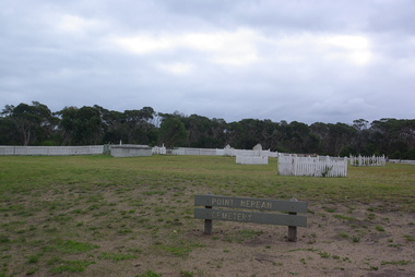
Photograph - Photograph - Colour, Clare Gervasoni, Point Nepean Cemetery, 24/05/2011
Colour photographs of the Potin Nepean Cemetery.point nepean, point nepean cemetery, jennie o'hara, john o'hara, edjar james taylor, frederick hicowe, george walker, edward skelton, harriet skelton, hannah ford, margaret ford, peter purves, elizabeth bowie, robert bowie, edward pike, john fercus, mary jane fercus, charles hugh fercus, ticonderoga, helen mcrae, sarah mcdonald, angus mcdonald, margaret mcdonald, william henry boyle, quarantine station -
 Ballarat Heritage Services
Photograph - Photograph - Colour, Former Homestead of William Rutledge at Port Fairy, 2017, 01/01/2017
In 2017 the building was used as the Port Fairy Youth Hostel.Photographs of a house in Port Fairy.Plaque "Emoli Original portion erected 1844 for merchant William Rutledge"william rutledge, port fairy, emoli, belfast, victoria -
 Ballarat Heritage Services
Photograph - Colour, Toilets, Old Sarum, England, English Heritage Site, 2016, 01 November 2016
William the Conqueror inherited Old Sarum from the last Saxon king of England. It was an ideal site for a royal castle. It was here in 1070 that William paid off his army after a long and bitter campaign in northern England. It was here in 1086 that he called together all the major landholders in England so they could swear allegiance to him. It was a crucial moment. The Domesday Book was being written, a threatened Viking invasion had only just been averted and William's eldest son was in armed rebellion. Old Sarum was an important place where this Norman king of England held power. In 1794 the Ordnance Survey set out to check the accuracy of the first mapping of Southern England, which had begun ten years earlier. From a point just below Old Sarum Lieutenant William Mudge laid out a base-line 36,574 feet (11,253 metres) long. From each end of the line the positions of distant places were plotted using a huge theodolite made in 1791 by Jesse Ramsden. The accuracy of the process, which was repeated all over England, depended on Jesse Ramsden's craftsmanship and on William Mudge's surveying skill in setting out this first base-line from Old Sarum. The nearer end of Mudge's line is marked by an inscribed stone beside the modern A345 at Old Sarum. ordnance survey, william mudge, jesse ramsden, william the conqueror, old sarum, saxon, 1086, england -
 Ballarat Heritage Services
Photograph - Colour, Stonework, Old Sarum, England, English Heritage Site, 2016, 01 November 2016
William the Conqueror inherited Old Sarum from the last Saxon king of England. It was an ideal site for a royal castle. It was here in 1070 that William paid off his army after a long and bitter campaign in northern England. It was here in 1086 that he called together all the major landholders in England so they could swear allegiance to him. It was a crucial moment. The Domesday Book was being written, a threatened Viking invasion had only just been averted and William's eldest son was in armed rebellion. Old Sarum was an important place where this Norman king of England held power. In 1794 the Ordnance Survey set out to check the accuracy of the first mapping of Southern England, which had begun ten years earlier. From a point just below Old Sarum Lieutenant William Mudge laid out a base-line 36,574 feet (11,253 metres) long. From each end of the line the positions of distant places were plotted using a huge theodolite made in 1791 by Jesse Ramsden. The accuracy of the process, which was repeated all over England, depended on Jesse Ramsden's craftsmanship and on William Mudge's surveying skill in setting out this first base-line from Old Sarum. The nearer end of Mudge's line is marked by an inscribed stone beside the modern A345 at Old Sarum. ordnance survey, william mudge, jesse ramsden, william the conqueror, old sarum, saxon, 1086, england -
 Ballarat Heritage Services
Photograph - Colour, looking from Stonework towards earth mounds, Old Sarum, England, English Heritage Site, 2016, 01 November 2016
William the Conqueror inherited Old Sarum from the last Saxon king of England. It was an ideal site for a royal castle. It was here in 1070 that William paid off his army after a long and bitter campaign in northern England. It was here in 1086 that he called together all the major landholders in England so they could swear allegiance to him. It was a crucial moment. The Domesday Book was being written, a threatened Viking invasion had only just been averted and William's eldest son was in armed rebellion. Old Sarum was an important place where this Norman king of England held power. In 1794 the Ordnance Survey set out to check the accuracy of the first mapping of Southern England, which had begun ten years earlier. From a point just below Old Sarum Lieutenant William Mudge laid out a base-line 36,574 feet (11,253 metres) long. From each end of the line the positions of distant places were plotted using a huge theodolite made in 1791 by Jesse Ramsden. The accuracy of the process, which was repeated all over England, depended on Jesse Ramsden's craftsmanship and on William Mudge's surveying skill in setting out this first base-line from Old Sarum. The nearer end of Mudge's line is marked by an inscribed stone beside the modern A345 at Old Sarum. ordnance survey, william mudge, jesse ramsden, william the conqueror, old sarum, saxon, 1086, england -
 Ballarat Heritage Services
Photograph - Colour, Looking from Stonework towards people walking on earth mounds, Old Sarum, England, English Heritage Site, 2016, 01 November 2016
William the Conqueror inherited Old Sarum from the last Saxon king of England. It was an ideal site for a royal castle. It was here in 1070 that William paid off his army after a long and bitter campaign in northern England. It was here in 1086 that he called together all the major landholders in England so they could swear allegiance to him. It was a crucial moment. The Domesday Book was being written, a threatened Viking invasion had only just been averted and William's eldest son was in armed rebellion. Old Sarum was an important place where this Norman king of England held power. In 1794 the Ordnance Survey set out to check the accuracy of the first mapping of Southern England, which had begun ten years earlier. From a point just below Old Sarum Lieutenant William Mudge laid out a base-line 36,574 feet (11,253 metres) long. From each end of the line the positions of distant places were plotted using a huge theodolite made in 1791 by Jesse Ramsden. The accuracy of the process, which was repeated all over England, depended on Jesse Ramsden's craftsmanship and on William Mudge's surveying skill in setting out this first base-line from Old Sarum. The nearer end of Mudge's line is marked by an inscribed stone beside the modern A345 at Old Sarum. ordnance survey, william mudge, jesse ramsden, william the conqueror, old sarum, saxon, 1086, england -
 Ballarat Heritage Services
Photograph - Colour, Stairs, Old Sarum, England, English Heritage Site, 2016, 01 November 2016
William the Conqueror inherited Old Sarum from the last Saxon king of England. It was an ideal site for a royal castle. It was here in 1070 that William paid off his army after a long and bitter campaign in northern England. It was here in 1086 that he called together all the major landholders in England so they could swear allegiance to him. It was a crucial moment. The Domesday Book was being written, a threatened Viking invasion had only just been averted and William's eldest son was in armed rebellion. Old Sarum was an important place where this Norman king of England held power. In 1794 the Ordnance Survey set out to check the accuracy of the first mapping of Southern England, which had begun ten years earlier. From a point just below Old Sarum Lieutenant William Mudge laid out a base-line 36,574 feet (11,253 metres) long. From each end of the line the positions of distant places were plotted using a huge theodolite made in 1791 by Jesse Ramsden. The accuracy of the process, which was repeated all over England, depended on Jesse Ramsden's craftsmanship and on William Mudge's surveying skill in setting out this first base-line from Old Sarum. The nearer end of Mudge's line is marked by an inscribed stone beside the modern A345 at Old Sarum. ordnance survey, william mudge, jesse ramsden, william the conqueror, old sarum, saxon, 1086, england -
 Ballarat Heritage Services
Photograph - Colour, Public toilets hidden in earth mound, Old Sarum, England, English Heritage Site, 2016, 01 November 2016
William the Conqueror inherited Old Sarum from the last Saxon king of England. It was an ideal site for a royal castle. It was here in 1070 that William paid off his army after a long and bitter campaign in northern England. It was here in 1086 that he called together all the major landholders in England so they could swear allegiance to him. It was a crucial moment. The Domesday Book was being written, a threatened Viking invasion had only just been averted and William's eldest son was in armed rebellion. Old Sarum was an important place where this Norman king of England held power. In 1794 the Ordnance Survey set out to check the accuracy of the first mapping of Southern England, which had begun ten years earlier. From a point just below Old Sarum Lieutenant William Mudge laid out a base-line 36,574 feet (11,253 metres) long. From each end of the line the positions of distant places were plotted using a huge theodolite made in 1791 by Jesse Ramsden. The accuracy of the process, which was repeated all over England, depended on Jesse Ramsden's craftsmanship and on William Mudge's surveying skill in setting out this first base-line from Old Sarum. The nearer end of Mudge's line is marked by an inscribed stone beside the modern A345 at Old Sarum. ordnance survey, william mudge, jesse ramsden, william the conqueror, old sarum, saxon, 1086, england -
 Ballarat Heritage Services
Photograph - Colour, Entrance to Public toilets hidden in earth mound, Old Sarum, England, English Heritage Site, 2016, 01 November 2016
William the Conqueror inherited Old Sarum from the last Saxon king of England. It was an ideal site for a royal castle. It was here in 1070 that William paid off his army after a long and bitter campaign in northern England. It was here in 1086 that he called together all the major landholders in England so they could swear allegiance to him. It was a crucial moment. The Domesday Book was being written, a threatened Viking invasion had only just been averted and William's eldest son was in armed rebellion. Old Sarum was an important place where this Norman king of England held power. In 1794 the Ordnance Survey set out to check the accuracy of the first mapping of Southern England, which had begun ten years earlier. From a point just below Old Sarum Lieutenant William Mudge laid out a base-line 36,574 feet (11,253 metres) long. From each end of the line the positions of distant places were plotted using a huge theodolite made in 1791 by Jesse Ramsden. The accuracy of the process, which was repeated all over England, depended on Jesse Ramsden's craftsmanship and on William Mudge's surveying skill in setting out this first base-line from Old Sarum. The nearer end of Mudge's line is marked by an inscribed stone beside the modern A345 at Old Sarum. ordnance survey, william mudge, jesse ramsden, william the conqueror, old sarum, saxon, 1086, england -
 Ballarat Heritage Services
Photograph - Colour, Masons' Marks, Old Sarum, England, English Heritage Site, 2016, 01 November 2016
William the Conqueror inherited Old Sarum from the last Saxon king of England. It was an ideal site for a royal castle. It was here in 1070 that William paid off his army after a long and bitter campaign in northern England. It was here in 1086 that he called together all the major landholders in England so they could swear allegiance to him. It was a crucial moment. The Domesday Book was being written, a threatened Viking invasion had only just been averted and William's eldest son was in armed rebellion. Old Sarum was an important place where this Norman king of England held power. In 1794 the Ordnance Survey set out to check the accuracy of the first mapping of Southern England, which had begun ten years earlier. From a point just below Old Sarum Lieutenant William Mudge laid out a base-line 36,574 feet (11,253 metres) long. From each end of the line the positions of distant places were plotted using a huge theodolite made in 1791 by Jesse Ramsden. The accuracy of the process, which was repeated all over England, depended on Jesse Ramsden's craftsmanship and on William Mudge's surveying skill in setting out this first base-line from Old Sarum. The nearer end of Mudge's line is marked by an inscribed stone beside the modern A345 at Old Sarum. ordnance survey, william mudge, jesse ramsden, william the conqueror, old sarum, saxon, 1086, england -
 Ballarat Heritage Services
Photograph - Colour, Masons' Marks, Old Sarum, England, English Heritage Site, 01 November 2016
William the Conqueror inherited Old Sarum from the last Saxon king of England. It was an ideal site for a royal castle. It was here in 1070 that William paid off his army after a long and bitter campaign in northern England. It was here in 1086 that he called together all the major landholders in England so they could swear allegiance to him. It was a crucial moment. The Domesday Book was being written, a threatened Viking invasion had only just been averted and William's eldest son was in armed rebellion. Old Sarum was an important place where this Norman king of England held power. In 1794 the Ordnance Survey set out to check the accuracy of the first mapping of Southern England, which had begun ten years earlier. From a point just below Old Sarum Lieutenant William Mudge laid out a base-line 36,574 feet (11,253 metres) long. From each end of the line the positions of distant places were plotted using a huge theodolite made in 1791 by Jesse Ramsden. The accuracy of the process, which was repeated all over England, depended on Jesse Ramsden's craftsmanship and on William Mudge's surveying skill in setting out this first base-line from Old Sarum. The nearer end of Mudge's line is marked by an inscribed stone beside the modern A345 at Old Sarum. ordnance survey, william mudge, jesse ramsden, william the conqueror, old sarum, saxon, 1086, england -
 Ballarat Heritage Services
Photograph - Colour, Masons' Marks, Old Sarum, England, English Heritage Site, 2016, 01 November 2016
William the Conqueror inherited Old Sarum from the last Saxon king of England. It was an ideal site for a royal castle. It was here in 1070 that William paid off his army after a long and bitter campaign in northern England. It was here in 1086 that he called together all the major landholders in England so they could swear allegiance to him. It was a crucial moment. The Domesday Book was being written, a threatened Viking invasion had only just been averted and William's eldest son was in armed rebellion. Old Sarum was an important place where this Norman king of England held power. In 1794 the Ordnance Survey set out to check the accuracy of the first mapping of Southern England, which had begun ten years earlier. From a point just below Old Sarum Lieutenant William Mudge laid out a base-line 36,574 feet (11,253 metres) long. From each end of the line the positions of distant places were plotted using a huge theodolite made in 1791 by Jesse Ramsden. The accuracy of the process, which was repeated all over England, depended on Jesse Ramsden's craftsmanship and on William Mudge's surveying skill in setting out this first base-line from Old Sarum. The nearer end of Mudge's line is marked by an inscribed stone beside the modern A345 at Old Sarum. ordnance survey, william mudge, jesse ramsden, william the conqueror, old sarum, saxon, 1086, england -
 Ballarat Heritage Services
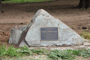
Photograph - Photograph - Colour, L.J. Gervasoni, Geoffrey William Powers Memorial, Avoca, 2011, 06/08/2011
Geoffrey Powers who was tireless worker for the Avoca community and a playground was named in his honour.Colour photograph of the Geoffrey William Powers Memorial in Avoca.This playground is dedicated to the memory of Geoffrey William Powers Geoff worked tirelessly for the Avoca community. Through his efforts many similar projects have been accomplished. Officially opened 2nd October 1994. From the citizens of Avoca. avoca, memorial, plaque, geoffrey william powers -
 Ballarat Heritage Services
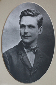
Photograph - Photograph - Black and White, William Ellis
Photographic portrait of William Elliswilliam ellis -
 Ballarat Heritage Services
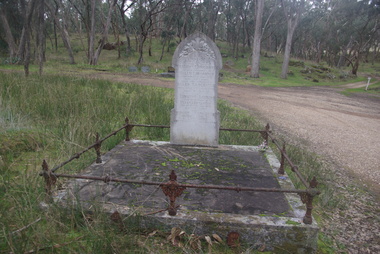
Photograph - Colour, Grave in Vaughan Cemetery, 2017, 16/07/2017
vaughan, vaughan cemetery, william lancaster, ellen lancaster, timothy larkins, bridget lancaster, e. lancaster -
 Ballarat Heritage Services
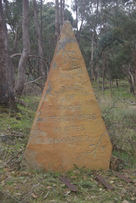
Photograph - Colour, Vaughan Cemetery, 2017, 16/07/2017
vaughan, vaughan cemetery, william lancaster, ellen lancaster, timothy larkins, bridget lancaster, e. lancaster -
 Ballarat Heritage Services
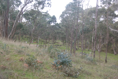
Photograph - Colour, Vaughan Cemetery, 2017, 16/07/2017
Colour photograph of the Vaughan Cemetery. vaughan, vaughan cemetery, william lancaster, ellen lancaster, timothy larkins, bridget lancaster, e. lancaster