Showing 10391 items
matching plan
-
 Canterbury History Group
Ephemera - Discover the secret, c.2000
Real estate advertisement for the sale of 10 Myrtle Grove Canterbury . Includes coloured photogarphs of the interior and exterior of the house, detail of leadlight window and floor and site planscanterbury, myrtle grove, edwardian style, leadlights -
Canterbury History Group
Ephemera - "The Mews" 6/24 Rochester Road Canterbury, [1992]
Real estate advertisement for the sale by auction of 6/24 Rochester Road Canterbury, on Saturday 13 June [1992] .Includes a sketch of the property and a floor and site plan.canterbury, rochester road, the mews -
Canterbury History Group
Ephemera - "Wyvenhoe" 40 Victoria Avenue Canterbury, 1991
Real estate advertisement for the sale by auction of "Wyvenhoe" 40 Victoria Avenue Canterbury on Saturday 7 September 1991. Includes a sketch of the exterior of the house and floor plan.canterbury, victoria avenue, wyvenhoe -
Canterbury History Group
Ephemera - 8/5 Willow Grove Canterbury, [1997]
Real estate advertisement for the sale by auction of 8/5 Willow Grove Canterbury on Saturday November 15 [1997]. Includes a sketch of the exterior of the building and a floor plan.canterbury, willow grove, home units -
Canterbury History Group
Ephemera - 36 Balwyn Road Canterbury, 1998
Real estate advertisement for the sale by auction of 36 Balwyn Road Canterbury on 14 March 1998.Includes coloured photograph of the exterior of the house and floor and site plans.canterbury, balwyn road -
Canterbury History Group
Ephemera - Excellence in design and presentation, {1997 or 2003}
Real estate advertisement for the sale by auction of 27 Hopetoun Avenue Canterbury on Saturday 13 September [1997 or 2003]. Includes a sketch of the house and floor and site planscanterbury, hopetoun avenue, townhouses -
 Falls Creek Historical Society
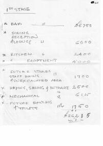
Document - Motel Planning - Hand-Written Figures - 1st Stage; 2nd Stage; Deletions, 30.04.1963
Bob (Herman) Hymans (a former member of the Royal Netherlands Navy) was born in Bloemendaal, Holland on 30th September 1922. During World War II he fought against the Japanese in the Dutch East Indies (now Indonesia) and was imprisoned in Changi and on the Burma Railway. After gaining qualifications as a Ski Instructor, Bob arrived in Falls Creek in July 1950. Working as an Instructor and Supervisor at Bogong Lodge, Bob decided his future was in accommodation. He was successful in negotiating an indenture for land from the State Electricity Commission (SEC). It took Bob two years to build his Grand Coeur Chalet but, tragically, it was burned down in August 1961. Bob also built the first Chairlift in Australia. This was a single chairlift and the structure was built from wooden electricity poles. He was constantly full of new ideas and proposals for the village. Bob Hymans die on 7th July 2007. This Collection of documents and letters tells the story of Bob's endeavours to develop Falls Creek into the ski village it is today.This Collection of documents and letters tells the story of Bob’s endeavours to develop Falls Creek into the ski village it is today. 6 sheets of handwritten notes recording cost estimates for different stages of Mr Hymans' plans for a new chalet on Site 4, Christie Street, Falls Creek.falls creek tourist area management committee, bob hymans, falls creek administration -
 Bacchus Marsh & District Historical Society
Map, Bacchus Marsh Region Parish Plans: Folded set of maps
Set of Victorian Lands Department Parish Plans covering the township of Bacchus Marsh and surrounding districts. Folded. BMDHS Location: AR/SU27/D2: Map Drawersmaps bacchus marsh region, bacchus marsh victoria maps, interim record -
Ringwood and District Historical Society
Plastic packet, PTC - Maroondah City Council, Public Transport Commission, Ringwood Railway Station Development Study, Interchange Upgrade, Community Workshops - various printed documents 1995-2013, 1995 to 2013
The urban consulting group commissioned Maroondah City Council and the Public Transport Feasibility Study, Ringwood Railway Station to be upgraded October 1995Various printed documents relating to PTC (Public Transport Commission), Maroondah City Council, Department of Transport - Ringwood Railway Station Redevelopment Study October 1995, Ringwood Station Bus interchange upgrade, designing new look Ringwood Station. Workshops were held for the community. +Additional Keywords: Ringwood Station Bus Interchange upgrade feed back sheet October 2011 / Ringwood Station Precinct Redevelopment Workshop held 26 July 2011 / Ringwood Station and bus upgrade December 2011 / Ringwood Town Centre South Project / Precinct Plans Planning Report. / Ringwood Town Centre Draft Report November 2000 / Ringwood Activities Community Newsletter August 2011 - Ringwood Station Update / State Government to sell Central Ringwood Railway land - Herald Sun 30 December 2013 / Ringwood Town Centre Precinct 4 Station Superblock for Railway Station July 2009 / Media release $66m station 15 April 2015 / Ringwood Station and Interchange Upgrade, Wednesday 27 August 2014 / Lifts left off upgrade plan - Leader Community Paper, 10 December 2013 / How to submit your feedback - Ringwood Station Precinct proposed concept, December 2011 / Designing a new look Ringwood Station workshop handout / State Government announces $66 million redevelopment of Ringwood Train Station, Herald Sun 6 June 2013 / Ringwood Station and bus interchange upgrade project update July 2012 / Set Concept design plans of $66 million Ringwood Railway Station over the years / Set photos of Ringwood Station taken between 2004 to 2005 / A3 drawing - Plan of Ringwood Station / A3 drawing - Ringwood Station proposed layout / A3 drawing - Old Station, Ringwood / A3 drawing - Proposed plan 2011 / A4 drawing - Final plan of Ringwood Station 2014 / A4 drawing - Proposed plan 2010 Ringwood Railway Station / A3 drawing - Proposed plan Ringwood Station with bridge across Maroondah Highway -
 Melbourne Tram Museum
Drawing, VR Sandringham Tram Depot, 1921
Set of 8 drawings, prints from original VR drawings of the Victorian Railways Sandringham Railway station, tram depot, bus depot and alterations between 1921 and 1958.\ .1 - VR Sandringham to Black Rock, Electric Street Railway – Car shed at Sandringham – Locality Plan – shows car depot layout, substation, track location for both the railway and tramway, including the platform, goods shed and coal stage. Not dated. Consists of two sheets of paper joined in the middle – 420H x 1210W. Minor creases at end of rolled sheet. .2 - Drawing 1907.21 - Sandringham car shed proposed extension – with note “Not carried out” – dated 2-8-21 Second copy has stamp – Drawer 2, Folio 1, plan 2 in bottom left hand corner. 480H x 630W .3 - Sandringham Station – station layout showing proposed extension to passenger platforms for both 7 and 10 car trains, buildings shops as the southern end of the yard, rail and tramway tracks, streets, dated 12.2.1923. Drawing 582.22. 420H x 590W. .4 - Locker Room for Bus Drivers – plan 264-46, dated 2-5-1946, 295H x 420W. .5 - Shower for Bus Drivers, Plan No. 815-50, dated 15/12/1950, 295H x 420W. Has a note on the drawing – “not carried out”. .6 - Tramcar shed – Site Plan – Entrance Gates – shows conversion arrangements of the depot from trams to buses, including entrance way gates. Plan 456-56. 295H x 420W. .7 - Conversion of sub-station into New Amenities Block - plan number 51-57, dated 22.2.1957 - Detail architectural drawings for the above work. 295H x 420W .8 - Conversion of sub-station into New Amenities Block - plan number 51-57, dated 22.2.1957 - Detail architectural drawings for the above work. 295H x 420W. .9 - Proposed Improvements to Bus Depot - Plan No. 455-52 - not dated. 420H x 595Wtrams, tramways, vr, sandringham, tramways, buses, railways, black rock -
 Greensborough Historical Society
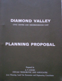
Planning Document, Diamond Valley Civic Centre and Neighbourhood Unit: Planning Proposal, 1960s
This document proposes the change of land use from farming and quarrying to residential. This also includes the proposal for a Civic Centre in the (then) Shire of Diamond Valley. The plans listed in the 'Schedule of Plans' on last page are missing.Includes proposal for the Aqueduct to be converted to an underground system. Includes statistics relating to population increase. Dark brown plastic folder. 23 foolscap-size pages. Maps, Application for Permits to subdivide land in the Greensborough area.partington family, mitchell family, whittingham family, albion reid, diamond valley civic centre, shire of diamond valley -
Glen Eira Historical Society
Plan - Monkleigh, Gladstone Parade, 12, Elsternwick
This file contains three items, the first a typed evaluation of Monkleigh to J.C. Ellis, Esq. from A.E. Lillie dated 02/12/1907. Also included is an original memo to J.C. Ellis, Esq. from A.E.Lillie dated 14/05/1908 with description and condition of house. Also included is a plan with outline dimensions of Monkleigh Land Unattributed, undated, handwritten note that Colin Wimberley lived at Monkleigh according to Sands and McDougall directory 1911.glenhuntly road, elsternwick, ellis j. c., lillie a.e., caulfield, gladstone parade, architectural features, monkleigh, trevelyan street, mansions -
 Ringwood and District Historical Society
Newspaper, Scrapbook Clipping, Library Collection, Ringwood, Victoria, `
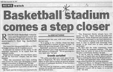
``Newspaper clipping from "The Mail" 28-9-93, P 3. NEWS watch. "Basketball stadium comes a step closer" by Jodie Haythorne Ringwood Basketball Association and Ringwood Council are forging ahead with plans for the municipality's first big basketball complex. The council has allocated $400,000 in its 1993-1994 budget towards the $1.3 million project.` -
 Kiewa Valley Historical Society
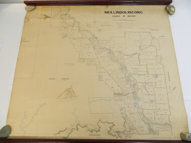
Map - Kiewa Valley, Parish Map of Mullindolingong, 12/10/1906
The map shows the names of people living in the parish of Mullindolingong in 1906. These people had leases or licences giving the reader an insight into the number of people in the area and an understanding of the size of their holdings. Infrastructure is also given including shops, schools, churches etc. Presumably it was used by the Ryder family.This map gives an historical insight into the parish of Mullindolingong as it names people and the infrastructure - roads, buildings etc. as it was in 1906. This enables the reader to compare the area at the time with other times and other places and to have an understanding of the early settlers in the area.This is a very old paper or parchment map with wooden rods top and bottom. The top rod has ribbons attached to enable hanging. The map shows the current leases and licences and when they were held by during this period, circa 1906.Mullindolingong County of Bogong. This plan has been prepared by The Most Reliable Data in the Possession of the Department up to the date of its Compilation. Information respecting Leases or Licences which await Final Completion is not recorded.parish of mullindolingong map; ryder family; early settlers; -
 Warrnambool and District Historical Society Inc.
Original Document, Map: Agricultural area of Ballangeich 1865, 1865
George Eddington arrived in Australia in 1839 and named and established property in 1841 calling the property Ballangeich after a Pass near his home town of Stirling in Scotland. It is situated 151 miles west of Melbourne and to the south of Mortlake and was originally part of the Mortlake shire, which was proclaimed 26th Jan 1864. Nearest streams are the Hopkins Riverand Lyall and Drysdale creek running through good agricultural land. This map relates to the breaking up of large runs which the Victorian government enabled through selection acts of the 1860's. The previously larger runs which were mainly cattle and sheep based were now more open to closer settlement and a greater variety in farming.The lots range in size from approximately 50 acres to around 600 acres.Some areas are set aside for reserves. By 1886 the population of Ballangeich had grown to around 600 with an hotel, three state schools and a church.Tri weekly coaches ran to Colac, Warrnambool and Camperdown providing access to supplies mail and communication. This map is typical of many which were produced in the 1860's in Victoria during a significant period of Victoria's and Warrnambool district history.Rectangular light card paper with black text showing allotments of land The area is coloured in green with scale at bottom right cornerAt the top: Plan of the Agricultural area of Ballangeich 1865 At the bottom left: Prepared by the Board of Lands & Works in accordance with the Amending Land Act 1865 Lands & Survey Office Melbourne 13th April 1865. With signaturehistory of warrnambool, ballangeich, land surveys victoria 1865, lands act 1865 victoria, ballangeich map 1865 -
 Ringwood and District Historical Society
Flyer, Land Auction Sale Brochure, Proclamation Estate, Ringwood, Victoria - circa 1963
Land sale auction advertisement - Proclamation Estate, Ringwood, with map of subdivision and summary of local features and services. Auction date, Saturday, March 2, (1963?), at 2pm.Subdivision plan includes Maidstone Street, Stanhope Court, Wrights Court, and Watirna Road. (Agents) Blackburn & Lockwood in conjunction with C.E. Carter & Son, 126 Whitehorse Road, Ringwood (Phone) 87 6024. -
 Ringwood and District Historical Society
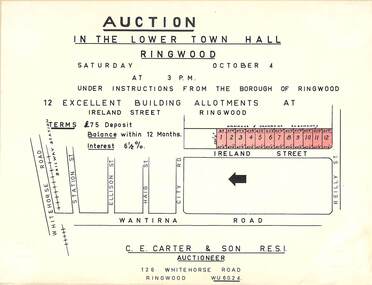
Flyer, Building Allotments Auction Notice - Ireland Street, Ringwood, Victoria - circa 1960
Notice attached to light cardboard backing advertising auction in the lower town hall, Ringwood, at 3pm, Saturday October 4 (1958?) for 12 building allotments in Ireland Street, Ringwood. Locality plan with red shading highlighting sites for auction in Ireland Street under instructions from the Borough of Ringwood. (Agent) C.E. Carter & Son, 126 Whitehorse Road, Ringwood (Phone) WU 6024. -
 Eltham District Historical Society Inc
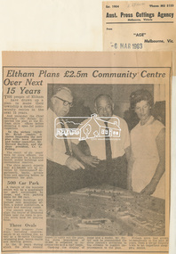
Newspaper Clipping, Eltham Plans £2.5m Community Centre Over Next 15 Years, The Age, 6 March 1963 page 7, 1963
Eltham Plans £2.5m Community Centre Over Next 15 Years THE people of Eltham have drawn up a plan to make their township a model community centre in the next 15 years. And yesterday the Chief Secretary (Mr Rylah) inspected the plan at the Eltham shire offices before declaring it open for public inspection In the picture (right) Mr. Rylah (centre) is shown inspecting the new plan with town planner and former councillor, Mr. Howard Bartlett, and the shire president, Cr. C. Pelling. The result of six years' work by shire officers, the plan provides for a business centre, public buildings and recreational reserves. The shire council expects that £2,500,000 will be invested by Government departments, banks, private firms and sporting bodies to implement the plan. 500 Car Park A feature of the business centre will be a quadrangle car park surrounded by shops, and with parking space for 500 cars. The public buildings will include new municipal offices, a public auditorium, a library and meeting rooms. The council plans to realign the course of Diamond Creek near the town to provide extra land for playing fields. Three Ovals The plan proposes three ovals, including improvements to an existing one, as well as a 50-metre Olympic swimming pool, tennis courts and bowling greens. In the 15 years which the shire council hopes to carry out the plan, the shire population of 18,000 is expected to increase two and a half times. Opening the display of maps and a model, Mr. Rylah said he commended the shire council's invitation to the citizens to suggest improvements to the plan. Eltham shire had grown tremendously in the past 20 years, from a sleepy country town to an important shopping centre. Digital file only of copy provided on loanauditorim, bowlong green, charis pelling, eltham community centre, rylah, howard bartlett, car park, library, forward plan -
Lakes Entrance Regional Historical Society (operating as Lakes Entrance History Centre & Museum)
Photograph, Lakes Post Newspaper, 1/12/1999 12:00:00 AM
Proposed plan shown on notice boardColour photograph showing Matt Martino Bill Daniel Mike Hurst and Gary Jeal at the launch of Golf Houses residential development Golf Links Road Lakes Entrance Victoriatourism -
Moorabbin Air Museum
Document (Item) - CAC F/A-18 Program Report on Visit by A. Pugh regarding Engine Bay Doors and Aft Nozzle Fairing Manufacture, Overseas Visit by: A. Pugh Period: 2 Weeks Task: Engine Bay Doors and Aft Nozzle Fairing
Overseas visit relates to N.T.F. Planning -
Glen Eira Historical Society
Document - Service Street, 9, Caulfield
Plan, hand drawn, 9 Service Street Caulfield c.1952, selling price written on plan. Includes hand written research by Claire Barton indicating that in 1948 the house was occupied by Albert B. Williams.service street, caulfield north, houses, outbuildings, williams albert b. -
 Glen Eira City Council History and Heritage Collection
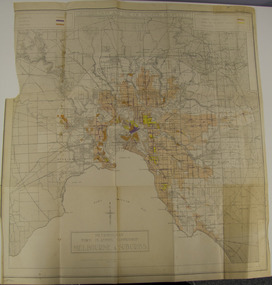
Map - Map, zoning, Metropolitan Town Planning Commission, "DISTRIBUTION AND USE OF EXISTING PROPERTY. MAP NO. 6.", 1929
The map titled: “Distribution and use of Existing property map No. 6” (Metropolitan Town Planning Commission Melbourne and Suburbs) is of historical significance. It is listed on page 168 of Chapter 4 the Zoning section of the "Plan of General Development Melbourne Report of the Metropolitan Town Planning Commission 1929" - Melbourne's first strategic plan. Map No. 6 is mentioned throughout Chapter 4 of the 1929 Report. It states on page 156 that this Map was created to graphically illustrate the data collected by the Planning Commission. The Map illustrates the general distribution of uses of existing property throughout the metropolitan area. The coloured sections show the areas which were developed or were in the process of development in 1929. The colours indicate the distribution of uses in the developed areas. The pink coloured areas, which include Caulfield, were almost completely residential.1929, metropolitan town planning commission, melbourne, suburbs -
Bendigo Historical Society Inc.
Document - STATE RIVERS AND WATER SUPPLY COMMISSION : KIMBOLTON RECREATIONAL AREA SEWERAGE PLAN
State Rivers and Water Supply Commission. Eppalock Project. Plan document titled: Kimbolton Recreational Area Committee. Sewerage of 'C' Section club sites. Rising Mains. Number 101378A is in bottom right corner. Diagrams: Detail pipe inlet at Lagoons, Detail pipe outlet. Plan scale: 1 inch = 6 chns. (The item referred to in this description has NOT BEEN SCANNED, due to the size of the item.state infrastructure, water supply, coliban system, state rivers and water supply commission. coliban system. eppalock. -
Bendigo Historical Society Inc.
Map - CAMPBELL COLLECTION: BENDIGO AND DISTRICT MAPS
Map. Eppalock, Sedgwick and Strathfieldsaye, scale 20 chains to 1 inch. Road to Bendigo 13 1/2 miles at top right of map, Longlea Railway Station 5 1/2 miles, Bendigo 11 miles, Strathfieldsaye 5 miles on left of map. Total area 3972 acres. Prepared in W.P.B. from Assessment Plan and Parish Plans. H.A. Darby 14-6-29.H.A.Darbymap, bendigo, agricultural lands -
Bendigo Historical Society Inc.
Map - UNITED HUSTLER'S & REDAN & K. K. MINES - PLAN OF UNITED HUSTLER'S & REDAN & K. K. MINES
Plan of the United Hustler's & Redan & K. K. Mines on the Hustler's Line of Reefs Bulletin No 33 Plate No XXVII. Plan shows depth of levels, Long Gully, Hustler's Line of Reefs, Lightning Hill Line of Reefs and approximate Boundary of Lease. Also mentions Comet Co. Geological Survey of Victoria emblem and signed by H S Whitelaw, Underground Survey Office Bendigo September 1913.mining, parish map, united hustler's & redan & k. k. mines, long gully, hustler's line of reefs, lightning hill line of reefs, comet co, h s whitelaw, geological survey of victoria, underground survey office -
Bendigo Historical Society Inc.
Document - LANDS OFFICE BENDIGO LITHO REGISTER, Jan. 1952 - Feb. 1978
Document: hard cover journal, black cover with buff spine and corners. Contains register of land maps sold by Bendigo Lands Office. Handwritten entries on ruled pages. LH page: date, number received, name of plan, litho number, price, amount, date, name of plan, price, number sold, amount, number used in office, amount. Rh page: repeat of LH page.Lands Office Bendigocottage, miners, bendigo, lands office, litho register -
Kew Historical Society Inc
Archive (series) - Subject File, McDonalds (Fast Food Restaurant)
Kew Historical SocietySince its foundation in 1958, members of the Kew Historical Society have been compiling and storing information about subjects relating to the history of Kew and its environs, of which this file is an example. Arranged by Secondary Values (value of records to users)Subject file created by researchers of the Kew Historical Society containing information about the McDonald's fast food franchise in High Street, Kew. The file contains a number of primary and secondary sources including newspaper cuttings, planning objections, correspondence between KHS, the City of Kew, the Administrative Appeals Tribunal, and the Department of Conservation and Natural Resources etc. The file also includes copies of the plans for the proposed restaurant. mcdonalds fast food franchises, mcdonalds restaurant -- kew (vic.), administrative affairs tribunalmcdonalds fast food franchises, mcdonalds restaurant -- kew (vic.), administrative affairs tribunal -
 Melbourne Tram Museum
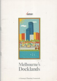
Document - Report, Ministry for Planning and Environment, "Melbourne's Docklands - A Strategic Planning Framework", 1989
Report - 32 A4 pages centre stapled colour printed on gloss paper, titled "Melbourne's Docklands - A Strategic Planning Framework", dated August 1989. Has a foreword by Tom Roper Minster for Planning and Environment. The report with a table of contents looks at the development of the Victoria Docklands area to the west of the railway yards. Has a good colour photograph of the area. Includes public transportation links using trams.trams, tramways, docklands, planning, melbourne, new track, public transport -
 Federation University Historical Collection
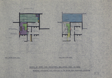
Plans, Preliminary Measured Drawings of the Former Gaol Governor's Residence Lydiard St, 1977
Four measured drawings on paper, with coloured shading: .1) Plan ground floor and first floor level .2) Proposed alterations and additions .3) as above .4) as abovegaol governor's residence, g. hewitt, smb, ballarat school of mines, architectural plans -
 Glenelg Shire Council Cultural Collection
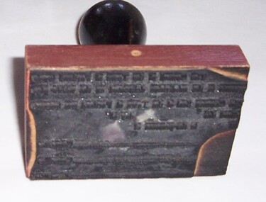
Functional object - Stamp - Subdivision Permit Stamp, n.d
Portland Town Council