Showing 6299 items
matching september
-
 Bendigo Military Museum
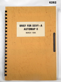
Administrative record - Brief for DSVY-A Automap 2 - March 1986, RJ McHenry Major for CO, 14 September 1987
Automap 2 is the second phase of a 3 phase project to introduce a computer assisted cartographic drafting system into service capable of capturing, storing and manipulating and outputting topographic data in digital form.A4 Folder, Orange Cardboard Cover, plastic ring bounding, "Arnos" fastener, text and diagramsroyal australian survey corps, rasvy, fortuna, army survey regiment, army svy regt, asr -
 Warrnambool and District Historical Society Inc.
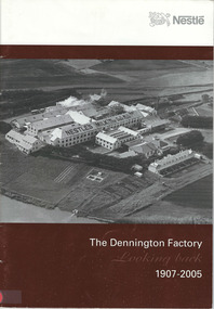
Document - Booklet, The Dennington Factory Looking back, 1907-2005, September 2005
This booklet records in brief the history of the Nestles Factory at Dennington, Victoria from its opening in 1911 to its sale in 2005 to Fonterra Milk, Australia and the closing of the Nestles association with the Warrnambool district. The factory initially produced Sweetened Condensed Milk and by 1918 was the largest Milk Condensery in the world. In later years there were productions of cheese, Sunshine Powdered Milk and Nescafe Instant Coffee. Six two-storey residences were built for employees and there were twice-daily trains from Warrnambool to the factory and back for many years. The Nestanglo Social and Sports Club, established in 1923, was important in the community life of Dennington and beyond. This booklet will be of great use as it gives a very good summary of the history of Nestles Factory at Dennington and reveals how important the factory was to the Warrnambool region and to Australia.This is a paperback booklet of 37 pages. The cover is white with a black and white photograph of the Nestles Factory (Alex Wilkins photograph) set in a brown background. The pages contain printed material and photographs and blank pages at the back for autographs. The pages are stapled.Front cover: Nestle (with logo), The Dennington Factory, Looking Back, 1907-2005 Back cover: Nestle (with logo) dennington nestles factory,, dennington, milk condensery, sweetened condensed milk manufacturing -
 Kiewa Valley Historical Society
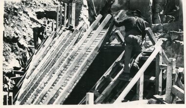
Photo - Junction Dam, September 1941
Junction Dam was part of the Hydro Electric Scheme during the 1940'sState Electricity Commission of Victoria construction of the Kiewa Hydro Electric SchemeBlack & white photo of Junction Dam constructionjunction dam, secv, bogong -
 Kiewa Valley Historical Society
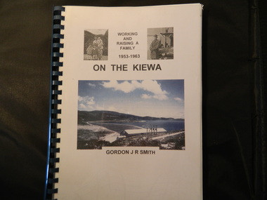
Book - On the Kiewa, Working & Raising a Family 1953 - 1963 by Gordon J. R. Smith, 9th September 2005
Personal account of Gordon Smith's life when living in Mt Beauty and Bogong townships while working for the SECV on the Kiewa Hydro Electric Scheme.Gordon gives an account of both working and living during the 1950s and early 1960s in a remote part of Victoria - the Kiewa Valley and in 2 small construction towns. He gives a lot of detail eg. the weather, his work, the people, the activities, his family and leisure time.Plastic threaded spine holding 282 pages with black and white photos. Front Cover includes 2 small black and white photos either side of the title at the top and below the title a larger colored photo of Rocky Valley Dam. Author's name is underneath. "Dick Puttyfoot" on cover page.kiewa hydro electric scheme, state electricity commission of victoria., gordon smith -
 Eltham District Historical Society Inc
Photograph, Fay Bridge, Warrandyte cool store, 9 September 2019
Remains of the old Warrandyte Dairy — Originally constructed to store milk for delivery from Mapleoak Dairies, delivered by the Bellinger family, up until the early 1970s. The Warrandyte Dairy closed in 1987 before the land and building was purchased by Melbourne Water in 1988 to reduce flood risk to the community and preserve riverside land from development on the site which sits on the Yarra River flood plain. In 2017, through a partnership with Manningham City Council, Warrandyte Historical Society and the Warrandyte Community Association, Melbourne Water renovated the 73-year-old site and installed interpretive signs detailing its history for the community.2019-09-09, fay bridge collection, warrandyte cool store, warrandyte dairy -
 Eltham District Historical Society Inc
Photograph, Fay Bridge, Allwood House, Hurstbridge, 9 September 2019
fay bridge collection, 2019-09-09, allwood house, hurstbridge -
 Eltham District Historical Society Inc
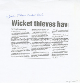
Document - Folder, Cricket, Diamond Valley Leader, Wicket thieves, 15 September 2004
A synthetic turf practice pitch has been stolen from the Eltham Cricket Club located at Eltham Central Park.Part photocopy of newspaper articlenon-fictionA synthetic turf practice pitch has been stolen from the Eltham Cricket Club located at Eltham Central Park. crime, theft, eltham central park, eltham cricket club, lionel draper -
 Eltham District Historical Society Inc
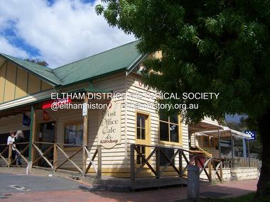
Photograph - Digital Photograph, Marguerite Marshall, Post Office, Hurstbridge, 27 September 2007
The Post Office building was built in 1918 by printer, Robert Charles Harris, owner of The Evelyn Observer newspaper. In 2007 a Post Office, cafe and giftshop operated from here. Covered under Heritage Overlay, Nillumbik Planning Scheme. Published: Nillumbik Now and Then / Marguerite Marshall 2008; photographs Alan King with Marguerite Marshall.; p13This collection of almost 130 photos about places and people within the Shire of Nillumbik, an urban and rural municipality in Melbourne's north, contributes to an understanding of the history of the Shire. Published in 2008 immediately prior to the Black Saturday bushfires of February 7, 2009, it documents sites that were impacted, and in some cases destroyed by the fires. It includes photographs taken especially for the publication, creating a unique time capsule representing the Shire in the early 21st century. It remains the most recent comprehenesive publication devoted to the Shire's history connecting local residents to the past. nillumbik now and then (marshall-king) collection, hurstbridge, post office, post office cafe -
 Eltham District Historical Society Inc
Photograph - Digital Photograph, Marguerite Marshall, Former Head Teacher's residence, Eltham Primary School, Dalton Street, Eltham, 7 September 2008
Built in 1891 for Head Teacher John Brown. His predecessor and the school's first Head Teacher, John Clark, lived in his own house 'Shoestring' in Metery Road, adjacent to the school. At the time of this photograph, the building was being used for before and after school care. Its present-day (2023) use is for school administration offices. Covered under Heritage Overlay, Nillumbik Planning Scheme. Published: Nillumbik Now and Then / Marguerite Marshall 2008; photographs Alan King with Marguerite Marshall.; p49This collection of almost 130 photos about places and people within the Shire of Nillumbik, an urban and rural municipality in Melbourne's north, contributes to an understanding of the history of the Shire. Published in 2008 immediately prior to the Black Saturday bushfires of February 7, 2009, it documents sites that were impacted, and in some cases destroyed by the fires. It includes photographs taken especially for the publication, creating a unique time capsule representing the Shire in the early 21st century. It remains the most recent comprehenesive publication devoted to the Shire's history connecting local residents to the past. nillumbik now and then (marshall-king) collection, dalton street, eltham, eltham primary school, headmaster's residence, main road, state school no. 209 -
 Eltham District Historical Society Inc
Photograph - Digital Photograph, Marguerite Marshall, St John's Anglican Church, Diamond Creek, 7 September 2008
The building was designed by Charles Maplestone of Heidelberg, son-in-law to Anthony Beale of St Helena. Maplestone was a prominent architect who came out to Australia with his family in 1852. The foundation stone was laid by Mrs Isabella Maplestone on 11th November 1867. The bricklayers for the church were George Stebbing, H Limmer, H Spicer and a Mr Timm while Thomas Day was the stonemason. Another three years were to pass before sufficient money could be raised for its completion. It was opened by Bishop Perry on 1st November, 1870. The church bell which hung under a tree for 50 years until it was incorporated in the parish hall was brought out from England and presented by Charles Orme. In 1916, the estate of George Martin Pizzey left sufficient money to build the red brick hall, which still stands today (2023) though in January 1969 the hall and bell tower were badly damaged by bushfire. Coincidentally the former home of benefactor, George Pizzey was destroyed in the same fire. Of particular significance are the interior and exterior of the church, the Sunday school and hall with emphasis on pre-World War I fabric (excluding the 1990s additions) and the three coloured glass windows currently suspended in the 1990s entry foyer. In 2011 further alterations were made to the front of the Church. The church is historically significant because it was the oldest public building in the former Diamond Valley Shire, is amongst the oldest buildings in the Shire of Nillumbik and is associated with the early settlement of the Diamond Creek district. The church is historically, socially and spiritually significant because it has been a place of worship for over 150 years and continues to be, an important meeting place in the Shire. The church is aesthetically significant for the three stained glass windows executed by the noted stained glass manufacturers, Ferguson & Urie, as well as the supporting coloured glass windows in the church. The Sunday school & parish hall is architecturally significant because the hall is a well executed and preserved example of the work of noted church architects, North & Williams. It is historically significant because it is connected with local parishioner and Melbourne industrialist, George Pizzey, who bequeathed funds for its construction. Covered under Heritage Overlay, Nillumbik Planning Scheme. National Estate Ntionl Trust of Australia (Victoria) Local significance Published: Nillumbik Now and Then / Marguerite Marshall 2008; photographs Alan King with Marguerite Marshall.; p85 References: St Johns Anglican Church complex, Sunday School and Parish Hall 61 Main Street DIAMOND CREEK, NILLUMBIK SHIRE. (2023, June 7). Retrieved from https://vhd.heritagecouncil.vic.gov.au/places/64023 Diamond Creek, VIC. – St John’s Anglican (2023, June 7). Retrieved from https://www.churchhistories.net.au/church-catalog/diamond-creek-vic-st-johns-anglican This collection of almost 130 photos about places and people within the Shire of Nillumbik, an urban and rural municipality in Melbourne's north, contributes to an understanding of the history of the Shire. Published in 2008 immediately prior to the Black Saturday bushfires of February 7, 2009, it documents sites that were impacted, and in some cases destroyed by the fires. It includes photographs taken especially for the publication, creating a unique time capsule representing the Shire in the early 21st century. It remains the most recent comprehenesive publication devoted to the Shire's history connecting local residents to the past. nillumbik now and then (marshall-king) collection, st john's anglican church, diamond creek -
 Eltham District Historical Society Inc
Photograph - Digital Photograph, Marguerite Marshall, Parish Hall, St John's Anglican Church, Diamond Creek, 7 September 2008
The building was designed by Charles Maplestone of Heidelberg, son-in-law to Anthony Beale of St Helena. Maplestone was a prominent architect who came out to Australia with his family in 1852. The foundation stone was laid by Mrs Isabella Maplestone on 11th November 1867. The bricklayers for the church were George Stebbing, H Limmer, H Spicer and a Mr Timm while Thomas Day was the stonemason. Another three years were to pass before sufficient money could be raised for its completion. It was opened by Bishop Perry on 1st November, 1870. The church bell which hung under a tree for 50 years until it was incorporated in the parish hall was brought out from England and presented by Charles Orme. In 1916, the estate of George Martin Pizzey left sufficient money to build the red brick hall, which still stands today (2023) though in January 1969 the hall and bell tower were badly damaged by bushfire. Coincidentally the former home of benefactor, George Pizzey was destroyed in the same fire. Of particular significance are the interior and exterior of the church, the Sunday school and hall with emphasis on pre-World War I fabric (excluding the 1990s additions) and the three coloured glass windows currently suspended in the 1990s entry foyer. In 2011 further alterations were made to the front of the Church. The church is historically significant because it was the oldest public building in the former Diamond Valley Shire, is amongst the oldest buildings in the Shire of Nillumbik and is associated with the early settlement of the Diamond Creek district. The church is historically, socially and spiritually significant because it has been a place of worship for over 150 years and continues to be, an important meeting place in the Shire. The church is aesthetically significant for the three stained glass windows executed by the noted stained glass manufacturers, Ferguson & Urie, as well as the supporting coloured glass windows in the church. The Sunday school & parish hall is architecturally significant because the hall is a well executed and preserved example of the work of noted church architects, North & Williams. It is historically significant because it is connected with local parishioner and Melbourne industrialist, George Pizzey, who bequeathed funds for its construction. Covered under Heritage Overlay, Nillumbik Planning Scheme. National Estate Ntionl Trust of Australia (Victoria) Local significance Published: Nillumbik Now and Then / Marguerite Marshall 2008; photographs Alan King with Marguerite Marshall.; p85 References: St Johns Anglican Church complex, Sunday School and Parish Hall 61 Main Street DIAMOND CREEK, NILLUMBIK SHIRE. (2023, June 7). Retrieved from https://vhd.heritagecouncil.vic.gov.au/places/64023 Diamond Creek, VIC. – St John’s Anglican (2023, June 7). Retrieved from https://www.churchhistories.net.au/church-catalog/diamond-creek-vic-st-johns-anglican This collection of almost 130 photos about places and people within the Shire of Nillumbik, an urban and rural municipality in Melbourne's north, contributes to an understanding of the history of the Shire. Published in 2008 immediately prior to the Black Saturday bushfires of February 7, 2009, it documents sites that were impacted, and in some cases destroyed by the fires. It includes photographs taken especially for the publication, creating a unique time capsule representing the Shire in the early 21st century. It remains the most recent comprehenesive publication devoted to the Shire's history connecting local residents to the past. nillumbik now and then (marshall-king) collection, st john's anglican church, diamond creek, parish hall -
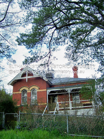
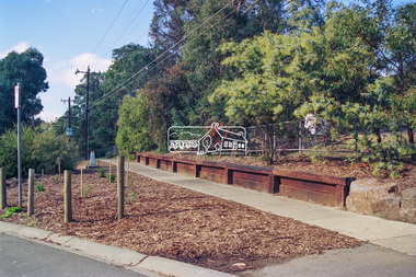
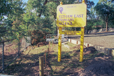
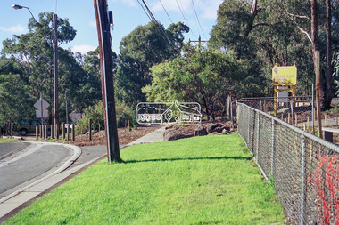 Eltham District Historical Society Inc
Photograph - Colour Print, Peter Pidgeon, Eltham East Primary School, Grove Street, Eltham, September 1999
These photos were taken to support an application regarding 'greening' in school landscapes. The school went on to win a voucher for education supplies from 'Windmill'. Eltham East Primary School was opened in August 1963.eltham east primary school, grove street -
 Eltham District Historical Society Inc
Photograph - Colour Print, Peter Pidgeon, Eltham East Primary School, Grove Street, Eltham, September 1999
These photos were taken to support an application regarding 'greening' in school landscapes. The school went on to win a voucher for education supplies from 'Windmill'. Eltham East Primary School was opened in August 1963.eltham east primary school, luck street, wildlife sanctuary -
 Eltham District Historical Society Inc
Photograph - Digital Photograph, Marguerite Marshall, Sutherland Home for Children, Diamond Creek, 27 September 2007
The Sutherland Homes for Children on Yan Yean Road, Diamond Creek cared for thousands of children from when it was opened in 1912. The site closed for this purpose in 1991 and was sold and later developed for commercial and office purposes. Covered under Heritage Overlay, Nillumbik Planning Scheme. Published: Nillumbik Now and Then / Marguerite Marshall 2008; photographs Alan King with Marguerite Marshall.; p107This collection of almost 130 photos about places and people within the Shire of Nillumbik, an urban and rural municipality in Melbourne's north, contributes to an understanding of the history of the Shire. Published in 2008 immediately prior to the Black Saturday bushfires of February 7, 2009, it documents sites that were impacted, and in some cases destroyed by the fires. It includes photographs taken especially for the publication, creating a unique time capsule representing the Shire in the early 21st century. It remains the most recent comprehenesive publication devoted to the Shire's history connecting local residents to the past. nillumbik now and then (marshall-king) collection, diamond creek, sutherland home for children -
 Eltham District Historical Society Inc
Photograph - Digital Photograph, Marguerite Marshall, Smith Dam, Karingal Drive, Eltham, 19 September 2006
The dam at the entrance to the Nerreman Gateway in Eltham was built according to an internationally acclaimed theory developed by the builder's father. In 1920, Victorian engineer B.A. Smith was awarded the American Society of Civil Engineers J. James R. Cross Gold Medal for his Technical Paper titled 'Arched Dams'. It was the first time this medal had been awarded outside the United States. The concrete arched dam across the Eltham West Drain was built in 1940 by B.A. Smith's son and engineer, D. B. (Bernie) Smith to water the 24 acre (9.75 ha) hobby farm owned by himself and new wife, Isa Smith. Upon completion of the dam a pump-house was constructed beside the creek but before the water could be pumped up the hill they had to dig a trench and lay 500m of 100mm water main to an elevated holding tank. The Smiths made the pump-house their home for several years until they constructed their home at the top of the hill overlooking Eltham and views extending to Kinglake. Following Bernie's death in 1983, Nerreman Park was subdivided between 1993 and 1995. Gordon Ford designed the landscaping and the pump-house was demolished. Covered under Heritage Overlay, Nillumbik Planning Scheme. Published: Nillumbik Now and Then / Marguerite Marshall 2008; photographs Alan King with Marguerite Marshall.; p137This collection of almost 130 photos about places and people within the Shire of Nillumbik, an urban and rural municipality in Melbourne's north, contributes to an understanding of the history of the Shire. Published in 2008 immediately prior to the Black Saturday bushfires of February 7, 2009, it documents sites that were impacted, and in some cases destroyed by the fires. It includes photographs taken especially for the publication, creating a unique time capsule representing the Shire in the early 21st century. It remains the most recent comprehenesive publication devoted to the Shire's history connecting local residents to the past. nillumbik now and then (marshall-king) collection, eltham, karingal drive, smiths dam, bernie smith, gordon ford, isa smith, nerreman gateway, nerreman park estate, dams -
 Eltham District Historical Society Inc
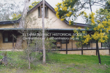
Photograph - Digital Photograph, Jim Connor, River Bend House, 130 Laughing Waters Road, Eltham, 7 September 2013
Laughing Waters Walk, 7 Sep 2013 This Society excursion was a follow up to the Laughing Waters Story told to us by Jane Woollard at our Annual General Meeting in March 2013. It involved a walk commencing from the corner of Laughing Waters and Overbank Roads along Laughing Waters Road to its eastern end and returning partly over the same route - a total distance of about 2.5km. On the way we visited the two artist in residence properties, River Bend and Birrarung, to view the houses on them that are associated with Alistair Knox, Gordon Ford and others in the local mud brick and artistic community. We also able to walk around the derelict ruin which was once home to Gordon and Sue Ford, Boomerang House. An unexpected afternoon tea was offered to us by the artists in residence at Birrarung House and we had a brief opportunity to view inside the house. River Bend was designed and built by Alistair Knox for Rosemary and Bill Cuming in 1968. It sits in a deep cutting on a steep slope above the Yarra River and features floor to ceiling windows and glass doors set into mission brown timber frames and walls of reclaimed bricks in pinkish hue. Rosemary laid the brick paving around the house, a copy of the shell paving found in the ancient French town of Colmar, where the family had lived for a period. The kitchen was equipped with a 1960s stove as well as a cast iron wood stove reclaimed from Rosemary's sister's home in Armadale. Max and Tini Huygens, migrants from Holland, purchased the property in 1975 and named it Tilwinda from an Aboriginal word meaning 'hole in a rock'. In late 1981 Tini died after a short illness, but Max continued to live at Tilwinda until he moved to a retirement village in 2000 and the property was sold to Parks Victoria. Renamed River Bend, the property became part of the Laughing Waters Artist in Residency Program in 2008. Nillumbik Shire Council upgraded the property in 2012 with solar panels, a heat pump for hot water and double glazing to improve the comfort of the artists in residence and make the house more energy efficient. For a more in-depth description of the property and biographies of the various artists in residence commencing from 2008 to 2015, see Jane Woollard's book, "Laughing Waters Road; Art, Landscape & Memory in Eltham" published 2016.2013-09-07, activities, artists in residence, eltham district historical society, heritage excursion, jim connor collection, laughing waters road, river bend house -
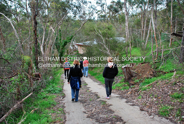
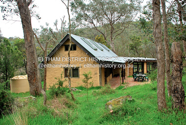 Eltham District Historical Society Inc
Photograph - Digital Photograph, Jim Connor, Birrarung House, 195 Laughing Waters Road, Eltham, 7 September 2013
Laughing Waters Walk, 7 Sep 2013 This Society excursion was a follow up to the Laughing Waters Story told to us by Jane Woollard at our Annual General Meeting in March 2013. It involved a walk commencing from the corner of Laughing Waters and Overbank Roads along Laughing Waters Road to its eastern end and returning partly over the same route - a total distance of about 2.5km. On the way we visited the two artist in residence properties, River Bend and Birrarung, to view the houses on them that are associated with Alistair Knox, Gordon Ford and others in the local mud brick and artistic community. We also able to walk around the derelict ruin which was once home to Gordon and Sue Ford, Boomerang House. An unexpected afternoon tea was offered to us by the artists in residence at Birrarung House and we had a brief opportunity to view inside the house. Birrarung is situated near the end of Laughing Waters Road. It was built in 1974 by Graeme Rose for Gordon Ford who he had asked to build him a small ‘bach’. Builder Peter Jarvis who did his apprenticeship with Alistair Knox for a couple of years recalled there were no drawings. It evolved as more funds became available. Graeme would source second-hand building materials around which he would shape the house. The fireplace was built with chicken wire over which it was rendered with faro cement. A brick floored glass studio, added later, faces a wall of boulders pressed into a manmade cliff, a large pond the link between the rock wall and glass studio. A waterfall, fed by river water, no longer functions. The property became part of the Laughing Waters Artist in Residency Program with the first artist taking up residency in 2001. For a more in-depth description of the property and biographies of the various artists in residence commencing from 2001 through to 2015, see Jane Woollard's book, "Laughing Waters Road; Art, Landscape & Memory in Eltham" published 2016.2013-09-07, activities, artists in residence, eltham district historical society, heritage excursion, jim connor collection, laughing waters road, birrarung house -
 Eltham District Historical Society Inc
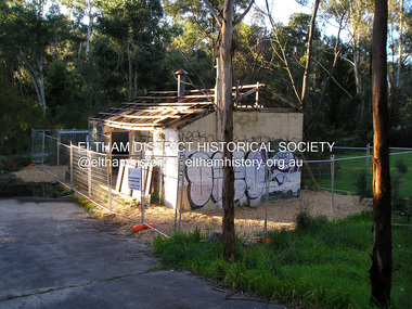
Photograph - Digital Photograph, Jim Connor, Boomerang House, 195 Laughing Waters Road, Eltham, 7 September 2013
Laughing Waters Walk, 7 Sep 2013 This Society excursion was a follow up to the Laughing Waters Story told to us by Jane Woollard at our Annual General Meeting in March 2013. It involved a walk commencing from the corner of Laughing Waters and Overbank Roads along Laughing Waters Road to its eastern end and returning partly over the same route - a total distance of about 2.5km. On the way we visited the two artist in residence properties, River Bend and Birrarung, to view the houses on them that are associated with Alistair Knox, Gordon Ford and others in the local mud brick and artistic community. We also able to walk around the derelict ruin which was once home to Gordon and Sue Ford, Boomerang House. An unexpected afternoon tea was offered to us by the artists in residence at Birrarung House and we had a brief opportunity to view inside the house. Gordon Ford and photographer Sue Winslow were married in 1965. They set up home in an old log cabin on the property Gordon had purchased in 1954 on Laughing Waters Road. Situated between the Yarra River and Overbank Road, Gordon had built a small mud-brick shack on the river and a pontoon. Over the decades the shack has been locally referred to as “the love shack”, the “rooting shack” or simply “Gordon’s shack”. Gordon and Sue commissioned local builder Graeme Rose to do a wattle and daub renovation and extension to the old log cabin on the north side of Laughing Waters Road. The work had only just been completed in 1965 when a bushfire swept through the area and destroyed the cabin. Gordon and Sue relocated to his property, Fulling, in Pitt Street, Eltham. In 1970 work started on a new house at the Laughing Waters property. Originally known as the Banana House, it is now known as Boomerang. Designed by Alistair Knox, the mud-brick house includes iron window grilles made by Matcham Skipper that puncture the curved mud walls. The grilles were made from ‘off-pressings’ from the Sidchrome tool works in Heidelberg. Gordon, Sue and family moved into the house in 1972. Their marriage fell apart and Sue moved to Sydney with the children around the same time Gordon commenced building Birrarung just below Boomerang on the Laughing Waters Road block. After the Fords moved out, Boomerang it was rented out to various share households of students, musicians, artists and environmentalists for twenty-four years. Gordon Ford sold Birrarung and Boomerang to Melbourne Water in 1999. The Laughing Waters Artist in Residence Program was developed as a partnership between Parks Victoria and Nillumbik Shire Council. Boomerang was deemed unfit for habitation so was used as a day studio only. By 2001 Boomerang was in a poor state of repair and by 2002 the last artist in residence was to use the house as a studio. Nillumbik Shire Council had been granted funds from the Melbourne Community Fund to restore both Boomerang and Birrarung but it was apparent in early 2003 that the funds would be insufficient to restore both houses. Boomerang was infested with termites which presented a risk to any occupants and so the decision was made to close Boomerang and concentrate funding on Birrarung. Boomerang was fenced off for safety and to prevent intrusion and remains ‘caged’ today (2023). However, it is readily apparent the property has been occupied by squatters over the years. By 2023 it was clear that the squatters had abandoned the property and sections of the roof structure have given away in some areas and collapsed internally. For a more in-depth description and history of the property and that of Gordon and Sue Ford, see Jane Woollard's book, "Laughing Waters Road; Art, Landscape & Memory in Eltham" published 2016.2013-09-07, activities, eltham district historical society, heritage excursion, jim connor collection, laughing waters road, boomerang house, gordon ford -
 Eltham District Historical Society Inc
Photograph - Digital Photograph, Jim Connor, The Love Shack, 195 Laughing Waters Road, Eltham, 7 September 2013
Laughing Waters Walk, 7 Sep 2013 This Society excursion was a follow up to the Laughing Waters Story told to us by Jane Woollard at our Annual General Meeting in March 2013. It involved a walk commencing from the corner of Laughing Waters and Overbank Roads along Laughing Waters Road to its eastern end and returning partly over the same route - a total distance of about 2.5km. On the way we visited the two artist in residence properties, River Bend and Birrarung, to view the houses on them that are associated with Alistair Knox, Gordon Ford and others in the local mud brick and artistic community. We also able to walk around the derelict ruin which was once home to Gordon and Sue Ford, Boomerang House. An unexpected afternoon tea was offered to us by the artists in residence at Birrarung House and we had a brief opportunity to view inside the house. Gordon Ford and photographer Sue Winslow were married in 1965. They set up home in an old log cabin on the property Gordon had purchased in 1954 on Laughing Waters Road. Situated between the Yarra River and Overbank Road, Gordon had built a small mud-brick shack on the river and a pontoon. Over the decades the shack has been locally referred to as “the love shack”, the “rooting shack” or simply “Gordon’s shack”. Gordon and Sue commissioned local builder Graeme Rose to do a wattle and daub renovation and extension to the old log cabin on the north side of Laughing Waters Road. The work had only just been completed in 1965 when a bushfire swept through the area and destroyed the cabin. Gordon and Sue relocated to his property, Fulling, in Pitt Street, Eltham. In 1970 work started on a new house at the Laughing Waters property. Originally known as the Banana House, it is now known as Boomerang. Designed by Alistair Knox, the mud-brick house includes iron window grilles made by Matcham Skipper that puncture the curved mud walls. The grilles were made from ‘off-pressings’ from the Sidchrome tool works in Heidelberg. Gordon, Sue and family moved into the house in 1972. Their marriage fell apart and Sue moved to Sydney with the children around the same time Gordon commenced building Birrarung just below Boomerang on the Laughing Waters Road block. After the Fords moved out, Boomerang it was rented out to various share households of students, musicians, artists and environmentalists for twenty-four years. Gordon Ford sold Birrarung and Boomerang to Melbourne Water in 1999. The Laughing Waters Artist in Residence Program was developed as a partnership between Parks Victoria and Nillumbik Shire Council. Boomerang was deemed unfit for habitation so was used as a day studio only. By 2001 Boomerang was in a poor state of repair and by 2002 the last artist in residence was to use the house as a studio. Nillumbik Shire Council had been granted funds from the Melbourne Community Fund to restore both Boomerang and Birrarung but it was apparent in early 2003 that the funds would be insufficient to restore both houses. Boomerang was infested with termites which presented a risk to any occupants and so the decision was made to close Boomerang and concentrate funding on Birrarung. Boomerang was fenced off for safety and to prevent intrusion and remains ‘caged’ today (2023). However, it is readily apparent the property has been occupied by squatters over the years. By 2023 it was clear that the squatters had abandoned the property and sections of the roof structure have given away in some areas and collapsed internally. For a more in-depth description and history of the property and that of Gordon and Sue Ford, see Jane Woollard's book, "Laughing Waters Road; Art, Landscape & Memory in Eltham" published 2016.2013-09-07, activities, eltham district historical society, heritage excursion, jim connor collection, laughing waters road, boomerang house, gordon ford, gordon's shack, love shack -
 Eltham District Historical Society Inc
Photograph, Fay Bridge, Birrarung House, 195 Laughing Waters Road, Eltham, 7 September 2013
Laughing Waters Walk, 7 Sep 2013 This Society excursion was a follow up to the Laughing Waters Story told to us by Jane Woollard at our Annual General Meeting in March 2013. It involved a walk commencing from the corner of Laughing Waters and Overbank Roads along Laughing Waters Road to its eastern end and returning partly over the same route - a total distance of about 2.5km. On the way we visited the two artist in residence properties, River Bend and Birrarung, to view the houses on them that are associated with Alistair Knox, Gordon Ford and others in the local mud brick and artistic community. We also able to walk around the derelict ruin which was once home to Gordon and Sue Ford, Boomerang House. An unexpected afternoon tea was offered to us by the artists in residence at Birrarung House and we had a brief opportunity to view inside the house. Birrarung is situated near the end of Laughing Waters Road. It was built in 1974 by Graeme Rose for Gordon Ford who he had asked to build him a small ‘bach’. Builder Peter Jarvis who did his apprenticeship with Alistair Knox for a couple of years recalled there were no drawings. It evolved as more funds became available. Graeme would source second-hand building materials around which he would shape the house. The fireplace was built with chicken wire over which it was rendered with faro cement. A brick floored glass studio, added later, faces a wall of boulders pressed into a manmade cliff, a large pond the link between the rock wall and glass studio. A waterfall, fed by river water, no longer functions. The property became part of the Laughing Waters Artist in Residency Program with the first artist taking up residency in 2001. For a more in-depth description of the property and biographies of the various artists in residence commencing from 2001 through to 2015, see Jane Woollard's book, "Laughing Waters Road; Art, Landscape & Memory in Eltham" published 2016.2013-09-07, activities, artists in residence, eltham district historical society, heritage excursion, laughing waters road, birrarung house, fay bridge collection -
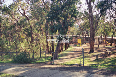
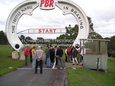 Eltham District Historical Society Inc
Photograph, Fay Bridge, Rob Roy Hill Climb Circuit, Clintons Road, Christmas Hills, 7 September 2013
Rob Roy-EDHS visit 12 May 2016 On 12th May 2016 some members of the Eltham District Historical Society and others were fortunate to have the opportunity to visit and explore the Rob Roy Hillclimb in Clintons Road, Christmas Hills. This followed an invitation from Don Kinsey and Wayne Ruston, members of the MG Car Club, which operates Rob Roy. At the time, both men were actively involved in the running of the meetings there, Don, an EDHS member, as a course commentator, with a wide range of motorsport experiences, and Wayne as the main organiser of the meetings. Don Kinsey welcomed the group and spoke about the historical background of the property and the hillclimb, then led those interested around the site and up the hillclimb track, stopping at spots along the way to provide additional information. Everyone enjoyed their experiences, including inspecting Wayne Ruston’s MGBV8. The Rob Roy Hill Climb originated in 1935 on the property of former Heidelberg Mayor, William Clinton, where he reared the Rob Roy breed of miniature ponies. He established Pleasure Grounds on part of the property attracting groups of Sunday visitors from Melbourne's inner suburbs. Visitors enjoyed a picnic area, pony rides, a dance hall and a tap room. Young men would ride their BSA or Harley Davidson motorcycles to the property which led to regular club-organised hillclimb meetings between 1930 and 1936. In 1935 Clinton offered the use of his property to the Light Car Club of Australia for their hillclimbs. The track was sealed that same year and the hillclimb at Clintons Road was one of only three specially designed bitumen surface hillclimbs in the world, the others being Shelsey Walsh and Prescott Hillclimbs in the UK. The first Light Car Club of Australia hillclimb was held at Rob Roy in February 1937.activities, eltham district historical society, heritage excursion, fay bridge collection, 2016-05-12, christmas hills, clintons road, rob roy hill climb -
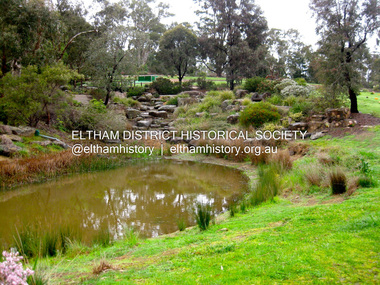 Eltham District Historical Society Inc
Photograph - Digital Photograph, Jim Connor, Lake, Eltham Cemetery, 40 Mount Pleasant Road, Eltham, 9 September 2009
Robert Boyle Landscape Design created the original design and construction of the lake in 1993. They are renowned local landscape designers and have carried out numerous projects at the Cemetery, including the major upgrades to the lakeside design in 2020.jim connor collection, eltham, eltham cemetery, lake, mount pleasant road -
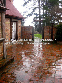 Eltham District Historical Society Inc
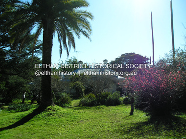
Photograph - Digital Photograph, Jim Connor, Residents Gallery, Montsalvat, 5 September 2010
jim connor collection, montsalvat, residents gallery