Showing 10953 items matching " land"
-
 Hume City Civic Collection
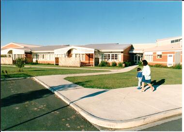
Photograph, early 1980s
Goonawarra Primary School was opened in the early 1980s to accommodate children who were living in the Goonawarra Housing Estate. Prior to development this area was known as Goonawarra Farm and John McMahon grazed his dairy cattle on the land.A coloured photograph of the recently completed Goonawarra Primary School. A lady and little boy are walking along the footpath in front of the building. There is an expanse of lawn between the path and the building.state education, schools, goonawarra primary school, goonawarra housing estate, goonawarra farm, ministry of education, george evans collection -
 Hume City Civic Collection
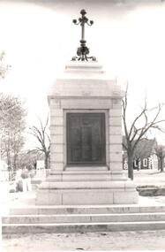
Photograph, post 1972
The Sunbury War Memorial is situated on a triangular section of land which was once at the intersection of Barkly and Stawell Streets. The precinct is also the site of the Rupertswood Gun and the Starkey Fountain. All are important historical exhibits related to Sunbury's history.A black and white photograph of a front view of the Sunbury War Memorial. The memorial has been placed on 3 steps at the base with a metal tablet set in a stone surround. There is a decorative metal pole at the top of the memorial. St. Mary's Church is in the background.war memorials, village green, st. mary's church, george evans collection -
 Stawell Historical Society Inc
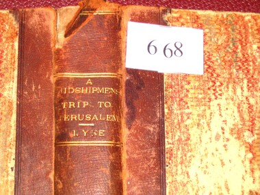
Book, Augustus A. Lyne R.N, A Midshipman’s Trip to Jerusalem, 1871
This book at one time belonged to the Pleasant Creek Library and Mechanic Insititute, Quartz Reefs. The Adventures of a cavalcade of British Naval Officers in the Holy Land. Dedicated by permission to: Captain George Lethbridge R.N. and the Officers of H.M.S. TrafalgarBrown Spine and Cornors, front and back patterned paper cover, part missing, clear tape on spine top and bottom. Top Right Inside Cover J.W. Evans & Co. Binders 11A Flinders Way. Notice pasted on inside of front Cover. No. 1313. Pleasant Creek Library and Mechanics Institute Quartz Reef. Members will be held responsible for any damage done to books in their possession.stawell education -
 Whitehorse Historical Society Inc.
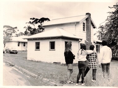
Photograph - Black and white photo, Winlaton Youth Training Centre
A house on the site was originally owned by successful businessman , Joseph Tweedle before being sold to the government. For many years it was the Winlaton Training Centre for girls. When the institution was closed the buildings were demolished and the land subdivided for housing.Four girls standing in the grounds of Winlaton outside a building.winlaton youth training centre, nunawading -
 Brimbank City Council
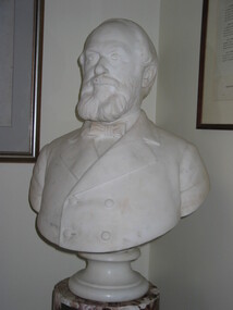
Marble bust on pedestal, W Taylor JP. The late executive coroner, 1934
William Taylor was one of the original white settlers in the area around modern day Keilor. He had a large amount of land and ran sheep in the area. Taylors Lake and Taylors Creek now bear his name. Figure of local historical significanceMarble bust on pedestalInscription on plinthwilliam taylor -
 Kew Historical Society Inc
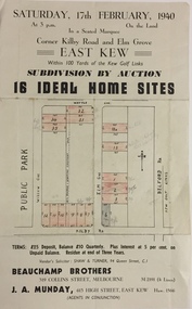
Plan - Subdivision Plan, Subdivision by Auction: 16 Ideal Home Sites, East Kew, 1940, 1940
An advertisement for the sale of a subdivision by Auction: of 16 Ideal Home Sites, East Kew, 1940. This significant sale of land between the Kew Golf Course and Willsmere Park led to the streets having a high degree of architectural uniformity.The subdivision in the second year of the war indicates that land sales for homes and speculation continued from the 1930s into the period of the Second World War. There is no indication on the plan that a war is occurring.Single page subdivision plan advertising the sale by Auction of 16 Ideal Home Sites, in East Kew, on 17 February 1940. Streets named in the plan include: Kilby Road, Belford Road, Elm Grove, Willow Grove. Willsmere Park is indicated but not named. The auction was conducted by Beauchamp Brothers. A number of lots are coloured pink on the plan indicating those lots for sale and/or those already sold.subdivision plans - kew east (vic) -
 Whitehorse Historical Society Inc.
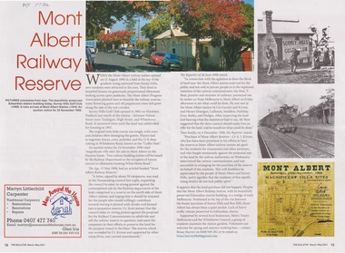
Article - The Bulletin article, The Bulletin, Mont Albert Railway Reserve, March-may 2021
After the Mont Albert Railway Station opened in 1890, 50 ratepayers petitioned the Nunawading Council to oppose the sale of the railway reserve to the north in order for it to become a recreation reserve.After the Mont Albert Railway Station opened in 1890, 50 ratepayers petitioned the Nunawading Council to oppose the sale of the railway reserve to the north in order for it to be a recreation reserve.non-fictionAfter the Mont Albert Railway Station opened in 1890, 50 ratepayers petitioned the Nunawading Council to oppose the sale of the railway reserve to the north in order for it to become a recreation reserve.mont albert, railway stations, surrey hills golf club -
 Bendigo Historical Society Inc.
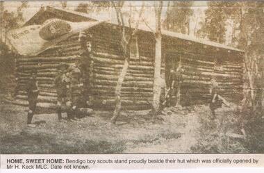
Newspaper - JENNY FOLEY COLLECTION: HOME SWEET HOME
Herbert Keck was a big supporter of the boy scouts and girl guides, often allowing them to camp on his property. It is likely that this hut was built in Spring Gully on land provided by Mr Keck. It opened 24/11/1930.Bendigo Advertiser '' The way we were'' from 2002. Home, sweet home: Bendigo boy scouts stand proudly beside their hut which was officially opened by Mr. H. Keck MLC. Date unknown. The clip is in a folder.newspaper, bendigo advertiser, the way we were -
 Eltham District Historical Society Inc
Photograph, View at Eltham, Vic, c.1924
Copy of possible Rose Stereograph Co. postcard “View at Eltham, Vic.”, c.1924 looking southwest from Main Road near York Street to Bridge Street and the original 1875 bridge across what is now the Alistair Knox Park The land in the foreground was first bought from the Crown by J.M. Holloway in 1851. The land was sub-divided and called "Little Eltham". Bridge Street was created as part of the sub-division. Most of the sub-division was residential lots but the creek valley was divided into lots for small farms. Council started to buy the land for the Eltham Town park in the early 1960s. The area was used as a garbage tip and filled above the flood plain of the creek. Development of the land for a park began in the early 1970s. The house on the right was owned for many years by the Hill family until Council bought it in the early 1960s. The house was built in the 1850s or 60s. The house on the left stood on what is now the southwest corner of Susan and Bridge Streets. The Braithwaite family was associated with this house. The double line of fencing in the foreground was a continuation of York Street to the creek. The Bridge Street bridge was built in 1875 and replaced in 1958. (Ref: Early view of Little Eltham; Byways of History by Colleen Ison, Publication unk, 24 August 1982) Reproduced on p61 of 'Pioneers & Painters' Date estimated on same as View at Hurstbridge featuring Wattle Valley EstateThis photo forms part of a collection of photographs gathered by the Shire of Eltham for their centenary project book,"Pioneers and Painters: 100 years of the Shire of Eltham" by Alan Marshall (1971). The collection of over 500 images is held in partnership between Eltham District Historical Society and Yarra Plenty Regional Library (Eltham Library) and is now formally known as the 'The Shire of Eltham Pioneers Photograph Collection.' It is significant in being the first community sourced collection representing the places and people of the Shire's first one hundred years.Digital image 120 format B&W negative Prints 17 x 25 cm and 10 x 15 cmsepp, shire of eltham pioneers photograph collection, eltham, bridge street, bridge, alistair knox park, braithwaite, bridge street bridge, eltham town park, hill family home, main road, pioneers and painters, york street -
 City of Moorabbin Historical Society (Operating the Box Cottage Museum)
Photograph, B&W Francis Box 1836-1912, c1900
Francis Box was born in Withyham, Sussex and came to Australia with his parents George and Mary Box and siblings in 1856. He was assigned to work in Beaufort and had various jobs including ‘gold miner’ at Heathcoat where he married Eliza Jane Thompson. Francis decided to return to market gardening after the death of his 1st child Francis George Box in 1875 aged 13months. The child was buried in Brighton Cemetery and Francis then rent/leased the land on the corner of Tucker Road and Elizabeth Street East Brighton ( now Bentleigh) owned by his brother Henry who with another brother John helped Francis clear the land, and establish a market garden. They had 4 children and began to prosper until in 1882 their 2year old child Lena Caroline Box was killed in a fire that destroyed their house. Francis was burned trying to rescue the child. The local community raised money to assist the family. The land boom brought prosperity again and Francis bought more land around Tucker Road which was bequeathed to his children. Francis and Eliza Jane had four more children but one died in infancy and another aged 2 years. Only 5 of their 9 children survived. Francis and Eliza Jane, who died in 1922, are also buried in Brighton CemeteryBox Cottage Museum, a reconstruction of an early settler hut, is named after the Box family who resided there 1865 -1913 . William Box who with his wife Elizabeth Avis Box and 13 children lived and farmed on the block of land in Jasper Road, East Brighton ( now McKinnon / Ormond) that was part of the Henry Dendy Special Survey 1841 Francis Box was born in Withyham, Sussex 1836 and came to Australia with his parents George and Mary Box and siblings in 1856. Francis, a brother of William Box, and his wife Eliza Jane Thompson had 9 children and established market gardens in Tucker Road, BentleighA black and white photograph of Francis Box 1836-1912FERRY ... Elizabeth St Melbournebox george, box mary, box william, box elizabeth honor, box alonzo, box mary louisa, dendy henry, were j b, dendy's special survey 1841, brighton, moorabbin, bentleigh, mckinnon, ormond, market gardeners, dairy farms, early settlers, pioneers, tucker road, box francis , thompson eliza jane, box william henry george, box charles francis, box-hembrow mable alma, box jessie melinda, box edith florence -
 Melton City Libraries
Photograph, Melton Shire Councillors, 1924
J.T Minns was president of the Shire Council from 1923-24 Isaac Robinson was president of the Shire Council from 1924-25. The Robinson family lived in the area. The following is from 100 Years at Melton: Isaac and Henrietta Robinson. Jeanette nee Rohner Robinson 1985. Creighton Melton. The Robinsons of Wyndham William Robinson married Ann Bee in 1952, Weardale, Durham England. They arrived in Australia on the ship “Ben Nevis” in 1852. They settled in Wyndham in 1855 and began dairying and haygrowing. They bought 50 acres and rented 300 acres until buying 300 acres in 1872 – Mt Pleasant Farm. Their children were sent to school even though Ann had been a school teacher in England. The older boys had to travel 5 ½ miles to Mt Cotterell school before one was built at Tarneit, a mile from their home. The children of William and Ann: George, Thomas, William, Isaac, Mary Ann, Mary Ann , John and Thomas. Thomas moved to Melton aged 19. When Ann died in 1898 Mt Pleasant farm was let then sold about 1920. In 1872 William Snr bought more land in Melton. William, Isaac and George worked on the land until 1887 when George and Isaac bought more land in Melton Creighton. Thomas and John also bought adjoining land. Outside Shire Offices, High Streetcouncil, local identities -
 Bendigo Historical Society Inc.
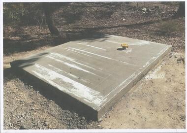
Photograph - Kangaroo Flat Gold Mine Collection: Catherine Reef South shaft
Kralcopic Pty Ltd, was a subsidiary of Bendigo-based company GBM Gold and had previously held mining licences around Bendigo, which incorporated sites including Kangaroo Flat, New Moon, Eaglehawk and the associated Woodvale Evaporation Ponds Complex. In August 2019, the Earth Resources Regulator decided not to renew Kralcopic’s three mining licences, due to the company’s inability to provide surety that it could finance its mining activities and site rehabilitation obligations. In October 2020, the company filed legal proceedings in the Supreme Court challenging the decision not to renew these licences. The Supreme Court later upheld the regulator’s decision not to renew the licences. On 23 April 2021, the Federal Court of Australia appointed KPMG as Kralcopic’s liquidators. On 14 May 2021, the liquidator lodged papers with the Australian Securities and Investment Commission (ASIC) to disclaim Kralcopic’s freehold land at Woodvale and parcels of land around the company’s former Bendigo sites, with the land to subsequently become Crown land. The Earth Resources Regulator has put a statutory exemption in place to preclude new mining licence applications on the sites while we undertake rehabilitation. The exemption also provides an opportunity for government to consider future uses of the sites in consultation with the City of Greater Bendigo and the local community. The Earth Resources Regulator holds rehabilitation bonds totalling $5.9 million, which it will use to rehabilitate the former sites.Colour photocopy of original photo. Image shows Catherine Reef South shaft with rectangular concrete capping. Ventilation pipe in concrete capping. On back in pencil: Catherine Reef South shaft with cap - Kralcopicwestern mining corporation, goldmining, capping, shaft, mining regulations, williams united shaft, kralcopic -
 Warrnambool and District Historical Society Inc.
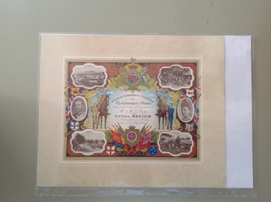
Certificate - Royal Review 1901 G Rolfe, 1901
This certificate was sent to those who had been present at one of the celebrations in connection with the Federation of the six States of Australia in 1901 – The Royal Review at Flemington Racecourse on 10th May 1901. The invitation to attend the event was issued by the Government of Victoria. The certificate was intended to be kept as a souvenir of the event and framed. This particular certificate was issued to George Rolfe and his wife of Warrnambool. George Rolfe (1836-1919), a tea merchant from Melbourne, began buying blocks of land near the mouth of the Hopkins River in Warrnambool in the 1870s. By the early 1880s he had acquired 50 acres of land in the town and several farming properties. He used the buildings on the land near the mouth of the Hopkins River as holiday accommodation and called the property, Lyndoch. He improved the property by adding stables, chaff and bone sheds, jetty, boathouse, reservoir, water well and windmill and extensive gardens and he spent most of his later life in the Warrnambool area. Lyndoch today is the site of an aged care facility. This certificate is of considerable importance for two reasons: 1. It is an important memento of a signal event on Australia’s history – the Federation of the six States in 1901 and the subsequent celebrations. 2. The certificate was issued to a prominent Warrnambool person, George Rolfe and his wife.This is multi-coloured sheet of paper mounted on card. There are four black and white photographs of the Royal Review at Flemington and photographs of the Duke and Duchess of Cornwall and York. The images include the Royal Crest, the shields of the six Australian States, a shield of Victoria with a background of flags, cannon and ammunition, two mounted soldiers with a soldier and sailor standing nearby and swords and bayonets. There is also much colour decoration around the edges of the certificate. The names of Mr and Mrs Rolfe are handwritten in black ink. ‘Australian Commonwealth Celebrations’ ‘The Government of Victoria requests the honour of the presence of Mr & Mrs G. Rolfe at the Royal Review at Flemington on Friday the 10th of May 1901’ federation of australian states, george rolfe of lyndoch, history of warrnambool, george rolfe -
 Warrnambool and District Historical Society Inc.
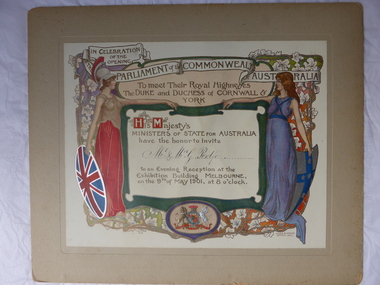
Certificate, Duke of Cornwall
This certificate is an invitation to the Evening Reception in Melbourne in 1901, an event which was part of the celebrations in Melbourne to commemorate the Federation of the six colonies into the six States of Australia in January 1901. The certificate was sent to the invitees after the event as a souvenir of the occasion. The certificate was designed by the artists Julian and Howard Ashton and lithographed and issued by Sands and McDougall Limited of Melbourne. This particular certificate was sent to George Rolfe and his wife Annie. George Rolfe (1836-1919), a tea merchant from Melbourne, began buying blocks of land near the mouth of the Hopkins River in the 1870s. By the early 1880s he had acquired 50 acres of land in the town and several nearby farming properties. He used the buildings on the land at the mouth of the River Hopkins as holiday accommodation and called this property Lyndoch. Rolfe improved this property adding stables, jetty, boathouse, bone and chaff sheds, reservoir and windmill and extensive gardens. Rolfe spent most of his later life at Lyndoch. Today the property is the site of an Aged Care Facility. This certificate is of considerable importance for two reasons: 1. It is an attractive and valuable memento of a signal event in Australia’s history – the Federation of the States in 1901. 2. The certificate was an invitation to Mr and Mrs George Rolfe. Rolfe was a prominent person in Warrnambool in the late 19th and early 20th centuries. This is a multi-coloured certificate mounted on a piece of grey cardboard. The certificate is highly embossed and has a figure of Britannia in a red dress and a mailed vest holding a shield with the Union Jack emblem. Britannia is extending her hand to a figure of a younger woman representing Australia. This figure is dressed in blue and holds a shield which has a blue cross with white stars. The borders have vines and vine leaves and the Royal Crest is at the base of the certificate. The names of the invitees are handwritten in black ink. ‘In Celebration of the Opening of the Parliament of the Commonwealth of Australia, To Meet Their Royal Highnesses, the Duke and Duchess of Cornwall and York, His Majesty’s Ministers of State for Australia have the honor to invite Mr & Mrs G. Rolfe to an Evening Reception at the Exhibition Building, Melbourne on the 9th of May 1901, at 8 0’clock’. george rolfe of lyndoch, warrnambool, federation of australia, history of warrnambool, george rolfe -
 City of Moorabbin Historical Society (Operating the Box Cottage Museum)
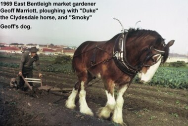
Photograph - Photograph: Horse-drawn Plough at Work, 1969 Geoff Marriott ploughing in his Market Garden, 1969
Members of the Marriott family arrived in Port Phillip in 1857. However it was John and Jane Marriott who in 1876, (after toiling hard since their arrival in1871, for very little gain), first leased, then purchased in 1882, 30 acres with a four-roomed house in East Boundary Road, in the area then called East Brighton. (Now known as East Bentleigh). The land they purchased had previously been a part of the 1841 Dendy Survey. Over the following years, John and his four sons with hard work and determination became prosperous vegetable growers and purchased further land in the area. Following John's retirement and subsequent death in 1903, the land was passed to his sons, and then onto the Marriott grandchildren. The family continued to remain very prosperous and successful vegetable growers. This lovely photo of Geoff Marriott bears testament to just one of the many families steeped in the tradition of vegetable growing which significantly contributed to the prosperity of the Shire, and its subsequent development into the City of Moorabbin. The photograph of Geoff Marriott of the Marriott family represents a typical example of the MANY early market gardening families, some names less prominent, but who with their labours contributed to the prosperity and the development of the community of the Shire of Moorabbin. This group of early pioneers, over many years, were a singularly important group responsible for the growth of schools, churches, the Mechanic's Hall, and were active in local government. Large coloured photograph, taken in 1969, showing Mr Geoff Marriott with his horse-drawn plough pulled by "Duke" the Clydesdale horse, and accompanied by "Smoky", his dog, working in his market garden, Brady Road, East Bentleighhorse, brighton, moorabbin, pioneers, settlers, fruit, markets, vegetables, plough, mayors, moorabbin shire, moorabbin roads board, marriott geoff, marriott john, marriott jane, market gardens, horse drawn plough, city of moorabbin -
 City of Kingston
Photograph - Digital image, Black and white, c. 1900
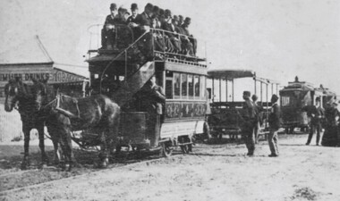
The availability of reliable regular and frequent public transport was very important to the land speculators of the 1880s. Charles H James, an early land speculator, had large holdings in the Shire of Moorabbin at Black Rock, Sandringham and Mentone. In 1884 he was advertising the auction of 109 blocks of land at ‘Picnic Point’ in the Brighton Southern Cross.[1] He provided free railway passes and conveyance to the grounds to prospective buyers. A proposal to extend the Brighton Railway to Sandringham and Black Rock seemed remote in 1884 so James acted to resolve the lack of public transport by forming his own tramway company. From the discussion between the Council and James it was agreed that the Council would apply for permission to construct a tramway on Beach Road. By February 8, 1889 the horse drawn trams were running from Cheltenham Station to Rickett’s Point and from Sandringham Station to ‘Blackrock Corner’. Although stricken with financial problems for its entire existence, Beaumaris Tramway Company continued until 1915.Black and white image of two horses. harnessed to a double decker tram, being pulled along the tram tracks laid in the street. There are men sitting on the top level of the tram, in the open air. Other trams are lined up behind this one, although with no people in them. The tram belongs to the Beaumaris Tramway Company. -
 Surrey Hills Historical Society Collection
Photograph, Holy Trinity Tennis Club, 1941, 1941
Holy Trinity originally held their first organised services during 1885 in the recreation hall in Albany Crescent, Surrey Hills with the Reverend H E Taylor, then Vicar of St Barnabas, Balwyn, conducting the services. Mr E D Dyer donated the land for a church on the corner of Mont Albert Road and St George's Road, Mont Albert with the foundation stone being laid on 17 July 1886. The first church service was held on Sunday, January 30, 1887 with eighty people present. A new site on Union Road, Surrey Hills was acquired (lots 3 & 4) and a wooden church was erected and opened in 1907 on lot 4. It became known as Holy Trinity Surrey Hills. In November 1939 two tennis courts and a pavilion were erected on land acquired by the parish in a lane off Balmoral Crescent. The Holy Trinity Tennis Club had 80 years of distinguished success in match play until it closed in 2014. That land was sold in 2015 and the parish's real estate holdings diversified.Black and white photo of 9 ladies, in tennis dresses and shoes, and 8 men, also in tennis attire. They are posed next to a light coloured building on the right and a paling fence along the back left side. There are 5 men standing at back, 6 ladies and 1 man standing in the next row, 4 ladies sitting in front and 2 men sitting on the ground. Three ladies sitting are holding tennis racquets. There are trees behind the paling fence. Black and white photo mounted on card; photo measures W 11.1 cm x H 6.7 cm.sporting clubs, sports people, tennis, holy trinity anglican church, 1940 - 1949, mrs mary clucas -
 Phillip Island and District Historical Society Inc.
Photograph, Newhaven punt and Nobbies tea house, 1928, 1929
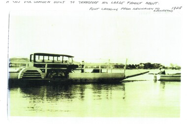
Historical4 A4 photocopies of black & white photos. A large bus on a punt with a person onboard. A small boat with 2 men towing the punt. Land in the background. Wooden building with a group of 6 people standing outside, one looking through telescope.with sloping roof and sign Ye Olde Tea House. Set on barren headland, sea in background with 2 small outbuildngs and a car parked beside building. Other photos show group of cars parked near the same building or on barren headland.A bus Dick Grayden built to transport his large family about 1928. Punt crossing from Newhaven to San Remo. Original tea house at Nobbies. 1929phillip island punt, richard grayden, the nobbies kiosk, point grant, motor car -
Ringwood and District Historical Society
Voters' Roll, "Mail" Print Ringwood (Tel 65), Voters' Roll 1924, Borough of Ringwood, South Eastern Province, Ringwood Division, c.1924
Arthur Fisher was the grandfather of Arthur G Lunt, RDHS cataloguer.Voters' Roll 1924, Borough of Ringwood, South Eastern Province, Ringwood Division. Names are marked with red crayon, presumably as vote is made. Brown cover, 39 pages, 703 names. E.Winterbottom, Returning Officer, Borough of Ringwood. Typical examples:Entry 202, Fisher, Arthur, Mullum Road, Orchardist, Owner, House and land, Warrandyte, �40, Votes 1Entry 558, Schwerkolt, Francisco, Mitcham, Owner, House, Ringwood, �22, Votes 1 +Additional Keywords: Fisher, Arthur / Winterbottom, E. / Schwerkolt, Francisco -
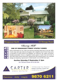 Ringwood and District Historical Society
Memorabilia - Booklet, Real Estate history of "Cherry Hill", 19 Wonga Road, Ringwood North, with property titles and subdivision plans of the 35 acres in the triangle bounded by Oban, Wonga and Warrandyte Roads
16 plastic pockets containing the history of "Cherry Hill". Titles and subdivision plans of the 35 acres in the triangle bounded by Oban, Wonga and Warranyte Roads, Ringwood North. Multi pocket burgundy coloured spiral binder containing 34 pages of the property history, subdivisions, land titles and photographs of the house, compiled by Richard Carter pre-auction 9 September 2006. Includes architectural descriptions of "Cherry Hill" from original allotment in 1872 to 2006. Also history of well known residents who lived in it. -
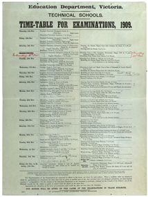 Federation University Historical Collection
poster, J. Kemp, Education Department Victoria Technical School Timetable for Examinations, 1910, 1910
Large printed timetable for Technical School examinations in 1901. Subjects included Chemistry, Geology, Asssaying, Hydraulics, Agriculture, Engineering , Mine Surveying, Algebra, Mineralogy, petrology, Botany, Trigonometry, Euclid, Land Surveying, Steam and gas Engines, Applied Mechanics, Drawing, painting, engineering drawing, building construction, architecture, drapery, modelled design, casting clay models, composition of form and colour, Lettering, Wood Carving, historic ornament, Wood Carving. .1) Trade Subjects .2) Other subjects, including artexaminations, technical schools, trades, art, technical art school, timetable, clay modelling, ceramics -
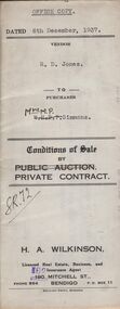 Bendigo Historical Society Inc.
Document - H.A. & S.R. WILKINSON COLLECTION: CONTRACT OF SALE
Conditions of sale by private contract dated 6th December, 1937 between R.D. Jones (seller) and Mrs. M.P. Simmons (buyer) for land situate in Thisle Street, Bendigo, being part of Crown allotment 17 section 17B described in conveyance no. 793, book 555, part of Crown allotment 18A described in certificate of title volume 6145 folio 1228836. Also the south eastern portion of allotment 18 section 17B described in residence area No. 7757. Price 120 pounds. Office copy.organization, business, h.a. & s.r wilkinson real estate -
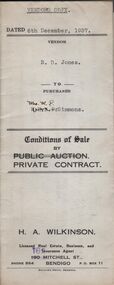 Bendigo Historical Society Inc.
Document - H.A. & S.R. WILKINSON COLLECTION: CONTRACT OF SALE
Conditions of sale by private contract dated 6th December, 1937 between R.D. Jones (seller) and Mrs. M.P. Simmons (buyer) for land situate in Thisle Street, Bendigo, being part of Crown allotment 17 section 17B described in conveyance no. 793, book 555, part of Crown allotment 18A described in certificate of title volume 6145 folio 1228836. Also the south eastern portion of allotment 18 section 17B described in residence area No. 7757. Price 120 pounds. Vendor's copy.organization, business, h.a. & s.r wilkinson real estate -
 Bendigo Historical Society Inc.
Document - H.A. & S.R. WILKINSON COLLECTION: CONDITION OF SALE
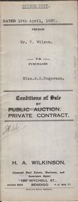
Conditions of sale by private contract dated 19th April, 1937 between Mr. T. Wilson (seller) and Miss E.E. Rogerson (buyer) for land situate 118 Violet Street, Bendigo, having a frontage of 100 links by a depth of 121.8 links on the South side and 132.4 links on the North side, being part of Crown allotment 14 section 12B described in Crown grant volume 2560 folio 515867, together with 5-roomed weatherboard dwelling and all sundry. Price 290 pounds.organization, business, h.a. & s.r wilkinson real estate -
 Bendigo Historical Society Inc.
Document - H.A. & S.R. WILKINSON COLLECTION: CONDITION OF SALE
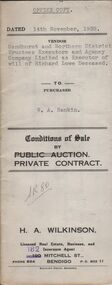
Conditions of sale by private contract dated 14th November, 1938 between Sandhurst and Northern District Trustees Executors and Agency Company Limited as Executor of will of Richard Lowe deceased (seller) and W. A. Rankin (buyer) for land situate No. 139 Olinda Street, Bendigo being part of Crown allotment 5 and 6 section 96C described in certificate of title volume 2367 folio 473243 and having 100 links to Olinda Street by a depth as fenced, together with 4-roomed weatherboard dwelling and all sundry. Price 800 pounds.organization, business, h.a. & s.r wilkinson real estate -
 Bendigo Historical Society Inc.
Document - H.A & S.R. WILKINSON COLLECTION: CONDITION OF SALE
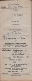
Conditions of sale by private contract issued by Bishop & Earl and H.A. Wilkinson and dated 25th July, 1949 between C.M. Taylor(seller) and F.W. Rogers + D.J. Rogers (buyers) land situate No. 47 Reginald Street Bendigo at present occupied by the purchaser as tenant, being part of Crown allotment 23 section 104C described in Crown grant volume 2052 folio 410334 as per plan of subdivision approved by the Bendigo Council, together with 4-roomed weatherboard dwelling and all sundry. Price 1,100 poundsorganization, business, h.a. & s.r wilkinson real estate -
 Bendigo Historical Society Inc.
Document - H.A. & S.R. WILKINSON COLLECTION: CONDITION OF SALE
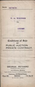
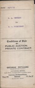
Conditions of sale by private contract issued by George Pethard Auctioneer and dated 10th October 1924 between H. A. Wilkinson as seller and H. A. Lindsay as buyer. Land situate corner of Peel and Hamlet Streets Bendigo being Crown allotment 2 section 145C Parish of Sandhurst City and county of Bendigo described in certificate of title volume 2935 folio 566916, together with 5-roomed weatherboard house and electric fittings, copper, bath and all sundry. Price 312 pounds and 10 shillings.organization, business, h.a. & s.r wilkinson real estate -
 Bendigo Historical Society Inc.
Document - H.A. & S.R. WILKINSON COLLECTION: CONDITION OF SALE
Conditions of sale by private contract dated 20th April 1925 between G. A. Pethard as seller and H. A. Wilkinson as buyer. Contract issued by George Pethard Auctioneer for sale of land situate in Elizabeth Street Nyah West being lot 100 on plan of subdivision No. 6415 lodged in the office of titles and being part of Crown Allotment 11 Parish of TynTynder West County of Tatchera described in certificate of title volume 4642 Folio 928297, together with 4-roomed weatherboard dwelling. Price 518 pounds.organization, business, h.a. & s.r wilkinson real estate -
 Bendigo Historical Society Inc.
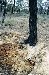
Photograph - DWYER COLLECTION: STONE WELL, MAIDEN GULLY
Photograph: image of stone well, Biffins Track, Maiden Gully. Circular structure lined with sandstone type stones. Measures 3.7 mt. across at widest point and is approx. 2.7 mt. deep. Large Ironbark on RH side of well. File contains letter from Mrs. Michele Dwyer, 27 Katherine Cres., Maiden Gully, dated 19th. Feb. 2003. Inspection by Kay MacGregor and Phil Wilkin in 2012 revealed well still intact, and on private property, not Crown Land. No heritage listing for well.bendigo, buildings, stone well, maiden gully, stone well, stonework, stone cutter. -
 Bendigo Historical Society Inc.
Document - H.A. & S.R. WILKINSON COLLECTION: CONTRACT OF SALE
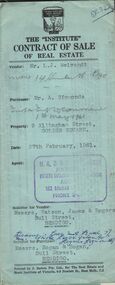
Contract of sale of real estate dated 27th February, 1961 between Mr. L. J. Neivandt (vendor) and Mr. A. Simmonds (purchaser). Solicitor for vendor: Messrs. Watson, James & Rogers, Bull Street, Bendigo. Solicitor for purchaser: Messrs. Hogan& Hogan, Bull Street, Bendigo. Property: 9 Allingham Street, Golden Square land described in right to occupy residence area No. 032 together with all linos, window blinds, electric light fittings and shades and cupboard in vestibule as inspected. Price 2,000 pounds.organization, business, h.a. & s.r wilkinson real estate