Showing 11126 items
matching planning
-
 Ringwood and District Historical Society
Capsule List, List of items in Maroondah Time Capsule. (undated), Unknown
List of local publications, plans, programmes, currency, maps etc., identified with the Maroondah area.List of items in Maroondah Time Capsule. Pale lemon coloured A4 page -
 Kiewa Valley Historical Society
Maps - Tawonga and Feathertop
Plan of Tawonga showing roads etc, rivers, use of land in 1968 and of Feathertop in 1969.Historical use of land in Tawonga and Feathertop.1. Topographical Map - Tawonga 803 Forests Commission of Victoria 1968. Cream paper with black print. Legend: Roads, tracks etc, rivers, Parishes and use of land. 2. Feathertop 813. 1969tawonga map 1968, tawonga parishes, feathertop map 1969 -
 Greensborough Historical Society
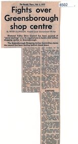
Article - Newspaper Clipping, The Herald, Fights over Greensborough shop centre, 03/02/1977
This article covers some of the issues when the development of Greensborough Plaza was in the planning stages in 1977.Shows local resistance to the building of a large shopping complex in Greensborough.News article, black textgreensborough plaza, shire of diamond valley, bob fell -
 Greensborough Historical Society
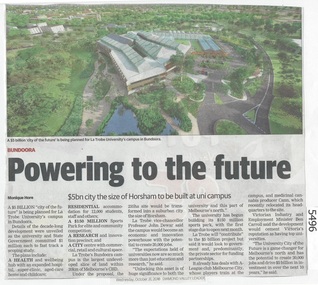
Newspaper Clipping, Diamond Valley Leader, Powering to the future: La Trobe University, 31/10/2018
A $5 billion city of the future is being planned for La Trobe University's campus in BundooraNews article 1 page, black text and colour image .bundoora, la trobe university -
 Greensborough Historical Society
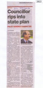
Newspaper Clipping, Diamond Valley Leader, Councillor rips into state plan, 09/03/2016
Cr Wayne Phillips comments on the Victorian government's planning issues regarding residential zones.News clipping, black text, colour image.wayne phillips, residential planning, banyule councillors, banyule city council -
 Eltham District Historical Society Inc
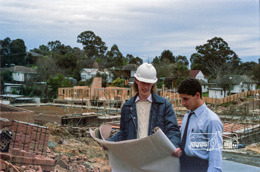
Photograph, Building site inspections, Shire of Eltham, c.1989, 1989c
Building inspectors (Danny Hick on left) from the Shire of Eltham review plans on site.Roll of 35mm colour negative film, 6 stripsFuji 100council staff, eltham shire council, shire of eltham, building construction, building inspector, danny hick, infrastructure -
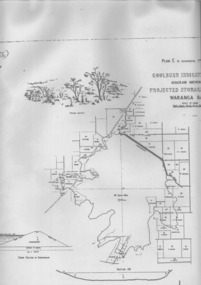 Tatura Irrigation & Wartime Camps Museum
Plan, Waranga Basin Project, c.1890
Original plan held at Tatura Office og Murray Goulburn Water, electronically copied.waranga basin, irrigation, agriculture, rural, industry -
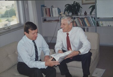 Vision Australia
Photograph - Image, John Moule and John Cook looking at the 1992 business plan, 1992
John Moule and John Cook sit in the CEO's office, looking at the 1992 business plan.3 coloured photograph of John Moule and John Cookjohn moule, john cook, association for the blind -
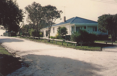 Lakes Entrance Historical Society
Photograph, Frank Price, Ninety Mile Beach Caravan Park Lake Tyers Beach Victoria, 1983 c
Building moved from Esplanade Lakes Entrance 1970 c. Floor plan in binderColour photograph of family residence of Frank and Wendy Price of Ninety Mile Beach Caravan Park Lake Tyers Beach Victoriaboats and boating, tourism, caravan parks -
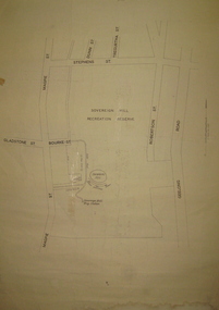 Federation University Historical Collection
Plan, Sovereign Hill Recreation Reserve and Surrounds
This map was probably produced around the time that the Sovereign Hill Museums Association was established. A simple plan with black marking on paper. It shows the Sovereign Hill Recreation Rerserve, including the swimming pool located near the Sovereign Hill Trig Point, showers, toilets, kiosk, bandstand and pine trees. The plan also depicts the Ballarat East streets surrounding Sovereign hill, including Geelong Road, Magpie Street, Stephens Street, Tregurtha Street, Dunn Street, Bourke Street, Gladstone Street and Robertson Street. The scale is 2 chains to 1 inch.sovereign hill, swimming pool -
 Federation University Historical Collection
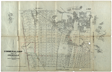
Plan, Commeralghip, County of Grenville, 1905, 03/02/1905
The Township of Kaleno is in the Pitfield Plains. The Cape Clear Cemetery T contains the graves of miners and local pioneering families from the Cape Clear, Hollybush, Kaleno, Pitfield Plains, Pitfield, Illabarook, Berringa, Springdallah, Wallinduc, Glenfine, Happy Valley and Western Creek districts.Plan of allotments in Commeralghip, County of Grenville, Victoria. The plan includes the township of Kaleno, Dereel Pre-Emptice Right (John Cullen), Commeralghip Pre-Emptive Right (John Gordon McMillan and Glenfine Pre-Emptive Right (William Rowe). It also includes landholders such as Robert mcPherson, C. Cameron. John Boyd, John Cullen, W.T. Rowe, George Currie, J.P. Mackay, T. McCaffery, G. Hawkins, Alexander McPherson, C. Cameron. Gift of the Squire Family, 2014commeralghip, pitfield plains, kaleno, dereel, glenfine, squire, richard squire, w.t. rowe, john cullen, alexander mcpherson, george currie, mt misery, william rowe, mindai, john gordon mcmillan -
 Federation University Historical Collection
Photograph - Photograph and Documents, Anne Beggs Sunter, Latta/Downing Family, Mount Helen
The Federation University Mt Helen Campus was once the farm of John Latta and his wife Elizabeth Ann Dean. The couple married in 1867 and had three children at the time of John Latta's death (Elizabeth Ann b.1870; Mary b.1873; John b.1875). Elizabeth later married George Downing, and had another six children. The house was situated in the vicinity of the current Administration and Caro Conference Centre buildings, surrounded by an orchard, and a well under the current Albert Coates Building (Union Building). The land was purchased by the Ballarat School of Mines for their tertiary division from the Stapleton family.Various items relating to the Federation University Mount Helen Campus, and the early settlers on the land, the Latta Family. .1) Parish Plan, including E. Latta, M. Fiscalini, R. Wynne, R. Nixon, J.U. Smith, J. Davis .2) Part of a 1930s ordinance map showing Ballarat, Buninyong and Greenhill .3) Contour Map with the first two Mt Helen Campus buildings included. .4) Drawing a a proposed campus plan .5) Latta Family negativemount helen campus, latta family, greenhill, e. latta, m. fiscalini, r. wynne, r. nixon, j.u. smith, j. davis, parish plan, john latta, elizabeth latta, george downing, elezabeth downing, green hill, pontresina, abraham baxter, g. dean, market gardens, jim downing, bob thornton, j. hateley, martin fanning, toll keeper, anne beggs sunter -
Bendigo Historical Society Inc.
Map - YALLOOK : COUNTY OF BENDIGO, 1957
Map. Yallook, County of Bendigo, Talambe, Neilborough, Yarraberb, Salisbury, Pompapiel. Drawn and reproduced at the Department of Lands and Survey, Melbourne,1957. Distances shown on the plan are derived from original surveys of varying dates and whilst approximately correct do not necessarily conform to modern standards of accuracy. For survey information application should be made to the central plan office, or to the office of titles. Some ink scibbles appear at the right top of this map. Price 2/-. (number 14 in map cupboard 1)By Authority W.M.Houston, Govt.Printer,Melbourne.map, bendigo, yallook -
 Bendigo Historical Society Inc.
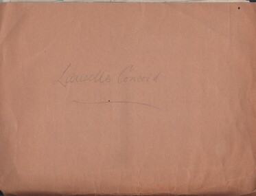
Document - MCCOLL, RANKIN AND STANISTREET COLLECTION: LANSELLS CONCORD GOLD MINING, 1934/1939
Documents: folder contains - Prospectus, Rent notices from Dept. of Mines, draft notes for prospectus, Dept. Mines, suspension of the Labour Covenant Lease No. 10024 Bendigo for three months expired 24/10/1934, application for shares forms, correspondence with Dept. of Mines re : Lease 10024, correspondence re Lease 10819, plans for Lease No. 10554, 10024, Dept letter - lease 10819 covers area of lease 10024, prospectus and plan of Bendigo Goldfields showing Lansells Concord Leases.MCCOLL RANKIN AND STANSISTREETorganization, business, gold mining, mccoll rankin and stansistreet, lansells concord gold mining. -
Whitehorse Historical Society Inc.
Newspaper - Article, 5 Longland Road, Heatherdale, 22/02/1984
Article in Nunawading Gazette re sale of 100 year old home at 5 Longland Road, Heatherdale. Double brick Victorian on bluestone foundations. Originally land was owned by Mr Witt who later became an M.P., later a master butcher. Mr Purches built the bluestone foundations. It was planned to have a village nearby to be called New Brunswick between Emery's Hill (now Mitcham) and what is now Ringwood. The only evidence of the once planned village is the existence of Brunswick Road nearby.longland road, mitcham, witt, william, purches (mr), brunswick road, mitcham, heatherdale, mitcham, emery's hill, real estate, auctions -
 Ballarat Tramway Museum
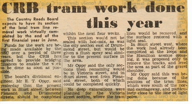
Newspaper, The Courier Ballarat, "CRB tram work done this year", 16/05/1972 12:00:00 AM
Newspaper clipping from The Courier, Ballarat, dated Tuesday 16/5/1972, titled "CRB tram work done this year". Item reporting on the plans of the CRB regarding the pace of removing the tram track on their roads. Quotes Divisional Engineer, Mr. E. T. Oppy that work should be completed by the end of the financial year. Reports on plans for Victoria St., Sturt St., Sturt St. West. One of a large group of newspaper cuttings from John Bainbridge, 7/4/02.track removal, crb, sturt st, sturt st west, victoria st -
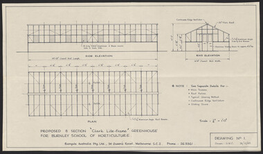 University of Melbourne, Burnley Campus Archives
Plan, "Clark Lite-Frame" Greenhouse, 1965
Plans for new greenhouse by Banyule Australia Pty. Ltd. (1) Drawing No 1 G.W.C. Proposed 8 Section "Clark Lite-Frame" Greenhouse for Burnley School of Horticulture, Plan Side Elevation, End Elevation. (2) Drawing No 2 Typical Glazing Detail, End Corner Detail, Typical Section Thru' Greenhouse. (3) Drawing No 3. Continuous Ridge Ventilator detail. Drawing No. 4. Sliding Door Arrangement. Drawing No 5. Framing Arrangement. Dated 24.10.1965 - 29.10.1965.banyule, greenhouse -
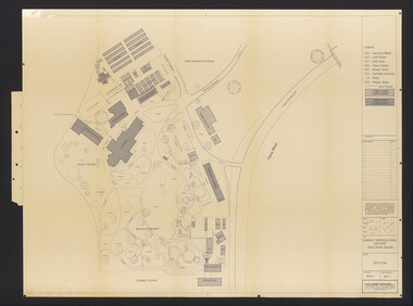 University of Melbourne, Burnley Campus Archives
Plan, Burnley Horticultural College: Site Plan, 1983-1984
Plans of the Burnley Campus, Ornamental Gardens from Plan 11.0715 by Alexander Metherell Pty. Ltd. Dated November 1983. Scale 1:500. (1) 5 copies, buildings shaded showing construction type. Job No BHC/1 Drawing No SP/1. Tree placements stamped on, includes legend. (2) 2 copies No SP/1c. In Description column, "A" Building Names 7/02/1984. Also see B15.0352 full report. B11.0715 originals. B11.0599 SP/3.ornamental gardens, burnley campus, burnley horticultural college, alexander metherell p/l -
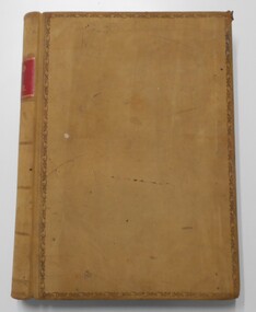 Bendigo Historical Society Inc.
Document - LANDS OFFICE: CERTIFIED PLAN REGISTER
Document: hard cover journal. Buff cover with embossed edges. Spine has red insert with 'Certified Plan Register' printed in gold. 250 pages, with index in front of register. LH page: number, date of receipt, name, parish, tracing book, plan, decision of Board of land and works, gazette page, name of surveyors, date of survey, sent to, date. RH page: précis of minute. Dated 1878 - 1893, includes areas in central and northern Victoria.plan register, lands office, bendigo, plans, surveyed, victoria, northern victoria -
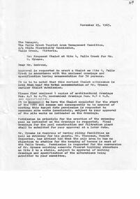 Falls Creek Historical Society
Document - Proposed Chalet At Site 4
Bob (Herman) Hymans (a former member of the Royal Netherlands Navy) was born in Bloemendaal, Holland on 30th September 1922. During World War II he fought against the Japanese in the Dutch East Indies (now Indonesia) and was imprisoned in Changi and on the Burma Railway. After gaining qualifications as a Ski Instructor, Bob arrived in Falls Creek in July 1950. Working as an Instructor and Supervisor at Bogong Lodge, Bob decided his future was in accommodation. He was successful in negotiating an indenture for land from the State Electricity Commission (SEC). It took Bob two years to build his Grand Coeur Chalet but, tragically, it was burned down in August 1961. Bob also built the first Chairlift in Australia. This was a single chairlift and the structure was built from wooden electricity poles. He was constantly full of new ideas and proposals for the village. Bob Hymans died on 7th July 2007. This Collection of documents and letters tells the story of Bob's endeavours to develop Falls Creek into the ski village it is today.This item is significant because it documents proposals put forward by Bob Hymans to develop facilities in the Falls Creek Tourist Area.A letter from J. Dale Fisher, an architect acting on behalf of Mr Hymans. The letter accompanied plans submitted to the SEC and the Management Committee for approval of the development of SIte 4, Christie Street, Falls Creek. The plans had been modified in response to earlier concerns related to cost. The new chalet would provide accommodation and a swimming pool and stables. Mr Hymans aimed to build a chalet which operated year round and would rival any of the resorts in New South Wales.falls creek tourist area management committee, bob hymans, falls creek administration -
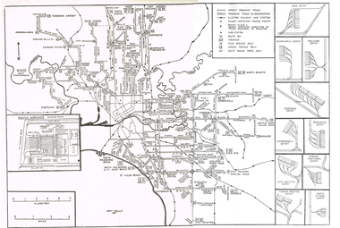 Melbourne Tram Museum
Map, Track plan or track map or layout of the Melbourne system, c1973
Track plan or track map or layout of the Melbourne system showing track layout, crossovers, depots, workshops and route numbers, terminus, substations, Bundy clocks, layout of Preston works. On the rear is a detailed layout of the city area. Shows railway stations but not the station names and rivers. Printed on cartridge paper. No details of to who prepared the plan or the drawing or date. Wattle Park line has been duplicated (Sept 1970), but the Essendon Airport line remains (closed Oct. 1976).trams, tramways, mmtb, track layout, junction, depots, substation, plans, trackwork, route numbers, terminus, map, bundy clock -
 Melbourne Tram Museum
Document - Report, Melbourne & Metropolitan Tramways Board (MMTB), "Melbourne and Metropolitan Tramways Board General Scheme", late 1950's
Report - 33 pages, duplicated, stapled within a grey "Roneo Numeralpha System" folder, titled "Melbourne and Metropolitan Tramways Board General Scheme" dated 30/11/1922 giving details of the Board's proposals for tramways to serve the Melbourne metropolis, gives details of the existing system, population, proposals for extensions, special services with a sheet on statistics and an appendix listing five plans and three graphs - not with this document. See Reg Item 2088 for another copy and 2089 for Plan A referred to.Stamped on report and cover "Chief Engineer"trams, tramways, mmtb, general scheme, tramways, development, parliament, brighton, railways, finances, construction -
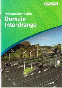 Melbourne Tram Museum
Document - Instruction Book, Yarra Trams, "New Operations Plan - Domain Interchange", 2013
Instruction book - 20 pages, printed on gloss paper, full colour, A5 centre stapled titled "New Operations Plan - Domain Interchange", outlining the change to the Domain Junction tram stop and track arrangements, that were built during March and April 2013. Has a table of contents, map, summary of changes, stop features, operations plan for St Kilda Road and Route 55 service, arrangements while being built, and general rules. Signed by Dennis Griffiths, Director of Operations.trams, tramways, yarra trams, domain junction, route 8, route 55, road works, st kilda rd, tram stops -
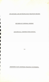 Melbourne Tram Museum
Document - Report, "Revision of General Scheme and Special Construction Scheme for Proposed East Burwood Tramway Extension", 1974
Report - Foolscap bound with black comb binder, 10 pages + two fold out drawings + card covers titled "Revision of General Scheme and Special Construction Scheme for Proposed East Burwood Tramway Extension", not formally dated (1974). Continuing information on the proposal such as route, existing services bus and rail, General Scheme, type of track construction, overhead, costs, fares, resumptions, plans. Includes plans P14604 (shows track arrangement) P14605 general location including the City of Melbourne.trams, tramways, east burwood, new tramways, general scheme, construction -
 University of Melbourne, Burnley Campus Archives
Plan, Plan Survey Perennial Border and environs and Spring Display, 1982-1990
(1) Tracing paper plan of bed. (2) Perennial Border Spring Display Planted 1982, plantings numbered but no names. (3) Pencil on paper, names of plants, some in pen. Area now known as the Grey Garden. Old Storage Shed cleared in 1979. (4) Tracing paper copy, VCAH Burnley Plan Survey: Perennial Border and Environs, dated 8.11.90. Scale 1:100. This might be where the Herbaceous Border is in 2012. (Also see 11.0615).gardens, vcah burnley, perennial border, spring flowers -
 Bendigo Historical Society Inc.
Map - FORTUNA HUSTLER'S MINE - PLAN OF FORTUNA HUSTLER'S MINE
Map and plan of the Fortuna Hustler's Mine on the Hustler's Line of Reefs. Bulletin No 33, Plate No 1. Plan gives depth of the different levels. Bendigo Railway Station is on the map and also a number of the streets. Carpenter Street is called Cemetery Road. Also on the Hustler's Line of Reef is the Summer Hill Shaft. Shown is the Hustler's Royal Reserve No 2 Lease. Map has the Geological Survey of Victoria crest. It is signed by H Whit ? an Underground Survey Office Bendigo, September 1913. map, fortuna hustler's mine, hustler's royal reserve no 2 lease, summer hill shaft, hustler's line of reef -
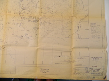 Kiewa Valley Historical Society
Plan - Kiewa Scheme General Plan 1958, S.E.C.V. Design & Construction Dept. Civil Branch, Dec. 1958
The Kiewa Hydro Electric Scheme was constructed by the State Electricity Commission of Victoria. Draftsmen drew up the plan of the layout as per the instructions from the engineers. The plan was drawn up on a transparency sheet and paper prints run off on a 'dyeline' copier. The 'Chief draftsman' and 'Design engineer' and 'Civil engineers recommended it and approved it. Historic: This plan gives a time line for the work on the Kiewa Hydro Electric Scheme. It is a good example of the work of a draftsman and the copying process in 1958.Large topography map of the area covered by the Kiewa Hydro Electric Scheme in 1958. Mountain peaks are marked in red and named. Rivers, roads, construction infrastructure as well as the main areas / names of construction are named. Signed and dated by employees of the S.E.C.V. working on the scheme.state electricity commission of victoria., kiewa hydro electric scheme, plan, engineer, draftsman -
 Eltham District Historical Society Inc
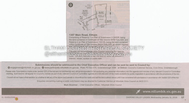
Document - Property Binder, 1307 Main Road, Eltham
Newspaper notice: Diamond Valley Leader, 31 January 2018, Calls for submissions re removal of reserve status and rezoning, Reserve 1 on Plan of Subdivision 213452R, Certificate of Title Volume 9879 Folio 829 and Reserve 2 on Plan of Subdivision 134133 Certificate of Title Volume 09434 Folio 620.main road, eltham, property -
 Melbourne Legacy
Document - Minutes, Minutes of meeting of Steering Committee (Future of Residences)
Minutes of the meeting held on 20 June 1974 to discuss the in-depth study authorised by the Board of Management. Items considered included the development of plans, forward planning, and funding of the project to look at options for Blamey House, Stanhope and Harelands. See also Cat Nos. 01689 and 01690. Further investigations were called for. Gives an insight into Legacy thinking about the way in which the residences should be used.White foolscap photocopy, with black type. Two holes punched for filing. Double sided.Page 2: 'L/tee H.C.G. Rodgers' hand written in blue biro.residences, review, blamey house, harelands, stanhope -
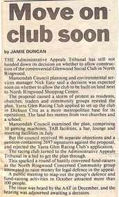 Ringwood and District Historical Society
Newspaper, Scrapbook Clipping, Library Collection, Ringwood, Victoria, `
``Newspaper clipping from "The Mail", 21-1-97, P11, Move on club soon. By Jamie Duncan The Administrative Appeals Tribunal has still not handed down its decision on whether to allow construction of the controversial Glenwood Social Club in North Ringwood. The proposal caused a storm of protest as residents, churches, traders and commumnity groups resisted the plan.`