Showing 55760 items
matching documents-maps
-
 Bendigo Historical Society Inc.
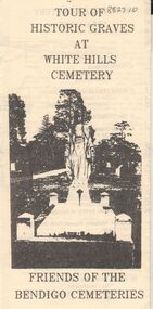
Document - BENDIGO CEMETERIES COLLECTION: SELF GUIDED TOUR HISTORIC GRAVES WHITE HILLS CEMETERY DOCUMENT
BHS CollectionLemon coloured trifold document : Tour of Historic Graves at White Hills Cemetery. Friends of the Bendigo Cemeteries. Map of White Hills Cemetery (1854 - 1993 ) showing marked grave sites with descriptions. E.g. Charles Merri Bux - 'Black Charlie' Indian hawker of Bendigo. History of White Cemetery on back page.Friends of Bendigo Cemeteriesbendigo, cemetery, white hills cemetery -
 Warrnambool and District Historical Society Inc.
Booklet - Warrnambool Visitor's Handbooks 1979-2024, Collett, Bain and Gaspar, Printers, 1979-2014
This is a collection of eight Warrnambool Visitor handbooks produced between 1979 and 2014 by the City of Warrnambool Tourist Information Centre. They contain maps of Warrnambool, lists of services, accommodation and tourist attractions as well as many advertisements for local businesses.These handbooks give a useful snapshot of businesses and tourist attractions in Warrnambool for each of the years covered. (1979, 1980, 1986, 1990, 1993, 1994, 1995, 2014)[.1a] A 48 page booklet with white pages and blue printing. The front cover has a coloured photograph of Flagstaff Hill with boats on a man made lake in the foreground looking across Lake Pertobe toward South Warrnambool. [.1b] A coloured bifold brochure. The front cover has a fisherman on a cray-boat holding a crayfish in the lower section. The top quarter has a blue back ground with white printing. The rear cover is red and has small photos of the Hopkins River and the Framlingham Forest. [.2] A 48 page booklet with white pages and black printing. The front cover is white with black writing on the left hand side and a colour photograph of the Loch Ard peacock. The Warrnambool Premier Town stylised logo of seven Norfollk pines above blue waves is in the top right hand corner. There is a blank ink Warrnambool Library stamp underneath the logo. The rear cover has photographs of The Twelve Apostles and the Hopkins Falls and the Premier Town Logo [.3] A 40 page booklet with mainly black printing on white paper. There are three fold out maps of Warrnambool and the surrounding district. The glossy cover has a black background with a colour photograph of the Twelve Apostles taken at sunset. The rear cover has three small of Proudfoot's boathouse on the Hopkins River, Flagstaff Hill, and the main beach area. The front cover has black writing inside to peach coloured rectangles. The inside rear cover has a fold out coloured tour map of Western Victoria. [.4] A 40 page booklet printed on glossy white paper with coloured photographs and black and red printing. The front cover has a photograph of The Twelve Apostles surrounded by a white border. There is red writing in the upper border. There is a sandy coloured writing superimposed across the bottom of the photograph and a Victoria's Shipwreck Coast logo in the bottom right hand corner. [.5] A 44 page booklet printed on white paper with black printing. The cream coloured cover has a pale red rectangle with blue writing on the right hand facing edge and includes two stylised Norfolk pines and with waves underneath. There is is an intersecting blue rectangle with cream printing. [.6] A 48 page booklet printed on white paper with black printing. The cover is brown with a cream vertical strip containing black writing on the right hand side. There is a stylised map from Geelong to Mount Gambier showing the Great Ocean Road across the cover. [.7] A 48 page booklet printed on white paper with black print. The glossy colour cover has a photograph of a Southern Right whale fluke. There is white printing on a the blue background of the sky and sea. The bottom left hand side of the front cover has a Tourism Victoria logo made of jigsaw puzzle pieces. The back cover has a stylised coloured map of The Great Ocean Road located in a white rectangle at the top of the page. Within the rectangle is a small map of Australia locating Victoria and the part of Victoria covered by the map. [.8] A 64 page A5 coloured booklet printed on white pages with black print. The white front cover has black and grey print with a colour photograph of two people holding coffee cups watching four race horses being exercised on the beach and in the water of Lady Bay in the early morning. The bottom right hand corner has a Tourism Victoria logo. The rear cover has a mainly blue back ground with a pink orange and green colour splats contains words advertising the 2015 Fun 4 Kids Festival [.1a] Warrnambool The Heart of Victoria's Great Southwest Visitor's Handbook [.1b] Warrnambool City for all seasons; The Heart of Victoria's Great Southwest [.2] Warrnambool visitor's handbook Warrnambool Premier Town 1979-1982 [.3] Warrnambool Handbook Victoria [.4] Warrnambool The Shipwreck Coast [.5] Welcome to Warrnambool Warrnambool Visitors Handbook 1993-1994 [.6] Welcome to Warrnambool Visitors Handbook 1994-95 Rear cover: Warrnambool Centre of Victoria's Shipwreck Coast on Australia's Great Ocean Road [.7] Warrnambool Shipwreck Coast - Great Ocean Road; You'll love every piece of Victoria; Visitors Handbook [.8] Warrnambool Great Ocean Road Official Visitor Guide; It's a wonderful Warrnambool; You'll love every piece of Victoria visitvictoria.com. Rear Cover Live entertainment.Workshops.Creativity.Action 28 June - 5 July 2015 Australia's Best Children's Festival F4K The ultimate winter school holiday adventure Fun 4 kids festival Warrnambool For more information visit Fun4kids.com.au Warrnambool great Ocean Road Victoriawarrnambool, visitor handbooks, tourist information guides, warrnambool maps -
 Bacchus Marsh & District Historical Society
Map, Balliang Parish Map, County of Grant c.1907
A single page paper map showing parish plan map for Balliang. This parish area contains the localities of Balliang and Balliang East and is located south of the township of Bacchus Marsh. The map is pasted into a bound volume containing 76 maps or plans in total. High resolution digital image stored on BMDHS computer network. balliang victoria maps, balliang parish maps -
 Glenelg Shire Council Cultural Collection
Map - Map - Portland, Victoria, n.d
Map of Portland, produced as an advertising medium by Portland Chicken Inn. Green card, dark blue print. Image of Portland Harbour on front, street index on back, open to Portland map, Chicken Inn marked on map. -
 Bendigo Historical Society Inc.
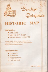
Document - BENDIGO GOLFIELDS HISTORIC MAP
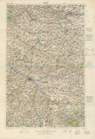
Bendigo goldfields historic map showing streets, lines of reef, principal shafts. Original map (dept of Mines) with additional material by members of RHSV (Bendigo Branch) . Price 30c. Map; is folded into envelope for sale and storage.place, bendigo, map -
 Bacchus Marsh & District Historical Society
Map, Gorrockburkchap Parish Map, County of Grant c.1915
The parish of Gorrockburkchap (sometimes spelled Gorrockburkghap) lies to the west and south west of the township of Bacchus Marsh. The locality of Rowsley is situated within this parish area.A single page paper map showing the parish plan for Gorrockburkchap in the County of Grant. The map is pasted into a bound volume containing 76 maps or plans in total. High resolution digital image stored on BMDHS computer network. gorrockburkchap parish maps, rowsley victoria maps -
 Bacchus Marsh & District Historical Society
Map, Gorrockburkchap Parish Map, County of Grant
The parish of Gorrockburkchap (sometimes spelled Gorrockburkghap) lies to the west and south west of the township of Bacchus Marsh. The locality of Rowsley is situated within this parish area.A single page paper map showing the parish plan for Gorrockburkchap in the County of Grant. The map is pasted into a bound volume containing 76 maps or plans in total. High resolution digital image stored on BMDHS computer network. gorrockburkchap parish maps, rowsley victoria maps -
 Bendigo Military Museum
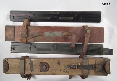
Instrument - Plane Table Surveying - Simple Alidade, ER Watts and Son, London, 1938
The Plane Table Alidade was used as the sighting Instrument in the production of historical manual hand drawn maps. A Plane Table Board mounted on a tripod is levelled and the Alidade is placed on the table with the vanes perpendicular to the it. Each sighting vane has a central thread lined up on the target and the angle to that target point is then drawn on the map sheet using the beveled fiducial edge. Plane Table Surveying is used as a quick method where less accuracy is required or needed. Plane table Surveying is a relatively portable and inexpensive method and was used extensively before the advent of sophisticated surveying instruments. The photo at 6489.2 is an Australian Army Survey Corps Party using a Plane Table Alidade in Syria during WWII. See also item 6580 which is the Plane Table with tripod legs that was used with the Alidade.Two Plane Table sighting instruments (Alidade) used for historical manual map making housed in wooden transit boxes. A brass instrument with folding sights at each end and a beveled fiducial edge in one edge. The front sight is the object vane and the rear sight is the sight vane. There is a sliding arm attached to the base to draw parallel lines to the fiducial edge. Very slight differences in model between these two instruments.First Instrument, "ER Watts and Son, London, 1938, MkII, Box Label 423. Second Instrument - R. E-Co, Mk.II, stamped E686, Box Label 686.royal australian survey corps, rasvy, fortuna, army survey regiment, army svy regt, asr -
 City of Kingston
Pamphlet - Colour, W. H. Wood Estate Agent, Subdivisional Land Auction Barker's Estate Cheltenham, 1919
Sales plan for land in the suburb of Cheltenham, along Barker StreetThe developing urban area of Cheltenham within the City of Kingston. This land sale pamphlet illustrates the subdivision of land within the municipality and the changing demographic of the district as new houses are constructed.Colour pamphlet advertising subdivisional land auction of Barker's estate, on Barker Street Cheltenham.Handwritten in grey pencil on the subdivision map: a series of numbers on each block possibly indicating the sale price. Handwritten in grey pencil on the subdivision map: Roy- joined to subdivision 6 Handwritten in grey pencil on the subdivision map: x on the border between subdivision 17 and 16, and again on the border between subdivision 12 and 11.cheltenham, land sales, estate -
 Kiewa Valley Historical Society
Maps - Bogong x2, Tawonga, Omeo, Dargo, Victoria and others, 1. Bogong Alpine Area; 2. Bogong 8324; 3. Tawonga Topographical; 4. Omeo 8433; 5. Dargo 8323; 6. Victoria State
... maps ...1. Bogong Alpine Area (outdoor Leisure Map. survey & Mapping Victoria, Government of Victoria, Edition 2, reprinted 1991 with an image of Mt. Feathertop on the front. Information for tourist in the Alpine National Park: Bogong Area. Including: recreational activities, history, weather and vegetation and a list of walks together with locality maps and photographs. The front cover has an image of Mt Feathertop against a blue sky with yellow writing 'Bogong Alpine Area', there is a yellow triangular block on the right hand top corner with black writing 'Outdoor Leisure Map. On the bottom edge is a block of yellow with black writing 'Survey & Mapping Victoria' and a light green map of Victoria with 'VICMSP' printed in white. 2. 8324 Bogong Victoria, Edition 1, Commonwealth of Australia 1981. A topographical Map: 1:100,000 scale (1 cm to 1 KM). Map has a red cover with white writing together with a white block and black writing and a map insert. 3. Tawonga Topographical Map - Forests Commission Victoria, / revised 5/9/77, DEG No. 68-G/399. A Tawonga 803 folded map in a beige colour with the back blank. 4. Omeo 8433 Victoria, Edition 1, Department of Natural Resources. The map has a red and white cover with black writing and a simple map of Australia at the bottom. 5. 8323 Dargo, Edition 1, Commonwealth of Australia. A red and white cover with a map insert. 6. Victoria State Map, Hema Maps, 2002. Hema Maps, State Map, colourful cover with a map of Australia and four tourism photographs. Scale 1: 850,000 An inscription handwritten in blue pen "Trappers Gap to Mitta Mitta 1" to 1 mile". There are some pen markings and notations of tracks.maps, bogong, omeo, tawonga, dargo, victoria, bogong alpine area -
 Lara RSL Sub Branch
Book, Australia in the War of 1939-1945 - Air War Against Germany and Italy 1939-1943. AIR Author John Herington, First published 1954
Australian contribution to air fighting against Germany and Italy with Australia being a small force against the larger, stronger air forces. The smaller Australian Airmen were merged into the Royal Air Force.Historical record of the AIR effort 1939-1943Australia in the War of 1939-1945 - Air War Against Germany and Italy 1939-1943 Illustrations, Maps, Diagrams and Graphs, MapsAustralian War Memorialgermany, italy, the battle of britain, syria, western desert, fighter squadrons in 1941, bomber command 1941, radar bombing, air war, tunisia, pathfinder raids, invasion of sicily, night fighters -
 Warrnambool RSL Sub Branch
Map, 1:100,000 LENS Edition 2, 1915, Minor Corrections 27/10/1916
Topographical Map. Full colour. Attached by glue to matching copy of 1:100,000 map sheet, 'Amiens' (as per 9002-Bob).snape collection -
Bendigo Historical Society Inc.
Map - CAMPBELL COLLECTION: BENDIGO AND DISTRICT MAPS
Map. Sedgwick. Parishes of Strathfieldsaye, Lyell and Sedgwick. Scale 20 chains to 1 inch. (number 359 in map cupboard 1)map, bendigo, agricultural lands -
Bendigo Historical Society Inc.
Map - CAMPBELL COLLECTION: BENDIGO AND DISTRICT MAPS
Map. Lyell, Parishes of Sedgwick, Eppalock and Lyell. Scale 20 chains to 1 inch. (number 348 in map cupboard 1)map, bendigo, agricultural lands -
Bendigo Historical Society Inc.
Map - MANDURANG, November 6th 1854
Map: The village of Mandurang situated about 6 miles from Sandhurst, Parish of Mandurang ( number 155 in Map Cupboard 1)map, bendigo, village, mandurang -
Bendigo Historical Society Inc.
Map - BENDIGO WEST IRRIGATION SETTLEMENT, 27/07/1910
Map: bendigo West Irrigation Settlement, Parish of Sandhurst, County of Bendigo. Parish plan ( number 193 in Map Cupboard 1)map, bendigo, irrigation settlement, bendigo west irrigation settlement -
Bendigo Historical Society Inc.
Map - BENDIGO WEST IRRIGATION SETTLEMENT, 13/02/1909
Map: Bendigo West Irrigation Settlement, Parish of Sandhurst, County of Bendigo. Parish plan. ( number 191 in Map Cupboard 1)map, bendigo, irrigation settlement, bendigo west irrigatioon settlement -
Bendigo Historical Society Inc.
Map - GEOLOGICAL MAP BENDIGO GOLDFIELD, See above
Map: Geological map of the Bendigo Goldfield comprising 2 sheets , Numbered 9358a and 9358b. Prepared in 1923 re-issued in 1936map, bendigo, geological, geological map, bendigo goldfield -
Bendigo Historical Society Inc.
Map - BENDIGO, October 1st 1893
Map: Bendigo, Plan of the whole county of Bendigo showing areas now available for selection (number 256 in map cupboard 1)map, bendigo, lands available for selection, bendigo, land available for selection -
Bendigo Historical Society Inc.
Map - TOWNSHIP OF HEAHCOTE SHEET 1, 29/07/1935
Map: Township of Heathcote sheet 1, parish of Heathcote, County of Dalhousie. Parish plan (number 253 in map cupboard 1)map, dalhousie, township, heathcote, conty of dalhousie -
Bendigo Historical Society Inc.
Map - PARISH OF EGERTON, 19/03/1894
Map: Parish of Egerton, Settlement on Lands Act 1893, County of Bendigo. Parish plan ( number 245 in Map Cupboard 1)map, bendigo, settlement on lands act 1893, egerton, settlement on lands act 1893. -
Bendigo Historical Society Inc.
Map - SANDHURST (PART), Circa 1880's
Map: Parish plan showing an area from McKenzie/View streets to Long Gully ( number 232 in Map Cupboard 1)map, bendigo, parish plan, sandhusrt, mckenzie street , view street, long gully -
Bendigo Historical Society Inc.
Map - LOCKWOOD, November 25th 1855
Map: Garden Allotments within the Town Reserve of Lockwood on the Bullock Creek. Parish plan (number 273 in map cupboard 1)map, bendigo, parish plan, lockwood, garden allotments, bullock creek -
Koorie Heritage Trust
Document - Printed Sheets, McBryde, I et al, The Distribution of Greenstone Axes in Southeastern Australia: preliminary report: Mankind Vol. 10 No. 3 June 1976: 163-174 "Wil-im-ee Moor-ring" or Where do axes come from? Mankind Vol. 11 1978: 354-82, 1976
Two papers outlining the greenstone sites in Victoria, their distribution and role in exhange in the communities.163-174 P.; maps; figs.refs.; bib. and vol 11 354-382 P.; maps; notes; graphs;tables; bib. Two papers outlining the greenstone sites in Victoria, their distribution and role in exhange in the communities. greenstone - quarry sites - victoria., aboriginal greenstone ?xes - south-eastern australia - sites., exchanged - greenstone - aborighinals, victoria. mount camel. -
 Ballarat Tramway Museum
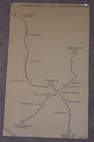
Map, "Bendigo Tramway Routes and Section Destinations", c1970
Demonstrates the layout of the Bendigo tramways, extracted from the Fare Schedule. Basis of production, source unknown. Associated with Eildon Hogan.Plastic coated, card mounted map showing diagrammatic routes of map of Bendigo routes, extracted from the SEC Fare Schedule.trams, tramways, bendigo, map -
 Bendigo Historical Society Inc.
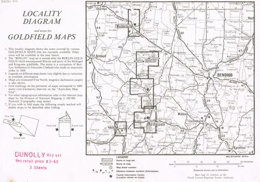
Document - JOAN O'SHEA COLLECTION: LOCALITY DIAGRAM AND NOTES FOR DUNNOLLY GOLDFIELD MAPS
Joan O'Shea Collection. Locality diagram and notes for goldfield maps. Dunolly map set. Wedderburn, Berlin, Dunolly, Maryborough, Avoca.mining, company exploration, dunolly map set. -
 Bendigo Historical Society Inc.
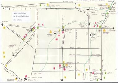
Map - MAP OF HISTORICAL SITES OF STRATHFIELDSAYE
On one side a map of the historical sites of Strathfieldsaye (not to scale) and on the other ten photographs of people and sites and a list of the sites marked on the map.bendigo, history, strathfieldsaye -
Camberwell Historical Society
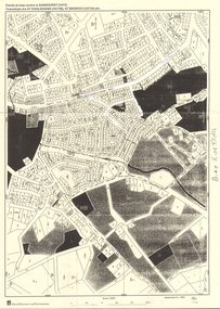
Ephemera - Objects, John Niemann et al, Camberwell Urban Conservation Study, 1989-1992
Letters re: Urban Conservation Study with map, Conserving Camberwell questionnaire, Urban Conservation Study booklet, and City of Camberwell mapcamberwell, urban conservation study -
 Bendigo Historical Society Inc.
Map - LONG GULLY HISTORY GROUP COLLECTION: MAP - EAGLEHAWK ROAD
BHS CollectionMap of part of Eaglehawk Road showing a Bike Ride Trail. Map is dated September 01, 1998, Scale 1:5000.bendigo, history, long gully history group, the long gully history group - map - eaglehawk road, natural resources and environment, bike ride trail -
 National Wool Museum
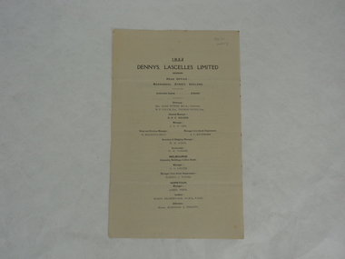
Annual Report, Dennys, Lascelles Limited Annual Report 1922
From a family who had three generations that worked for Dennys Lascelles. This is a balance sheet and annual report for the year 1922. Names of note featured in the document include DPC Wilson, WF Volum and JSB Orr.Off-white two page folded paper booklet with black text. Front page lists the directors and staff of Dennys Lascelles responsible for compiling the report. The inside pages state numbers and figures for the previous financial year. The back cover has a short paragraph about the document.