Showing 10536 items
matching lander
-
 Glen Eira Historical Society
Document - Bramerton, Bambra Road, Caulfield
One page undated, unattributed, typed note about Bramerton, Bambra Road, listing owner, date, property description and acreage. The file also includes a one page handwritten, undated note about Bramerton, Bambra Road, built for Arthur Palmer Blake, mentioning the property’s possible use as a military convalescent hostel in 1918. This was researched from book Land Boom and Bust by Cannon.bramerton, bambra road, blake arthur palmer, crotonhurst, stables, military hospital, nursing home, armed forces, caulfield -
Glen Eira Historical Society
Document - Caulfield City Rifle Club No. 119, 294 Glen Huntly Road, Elsternwick
Two pages of typed notes on the history of the Caulfield City Rifle Club by Kevin Armstrong, undated. The notes contain a timeline ranging from 1928 to 1969 with emphasis on the cost of ammunition an firearms over time. The file also includes two pages of handwritten research notes, undated and unattributed, about the various changes undergone throughout the early history, 1915 to 1941, of the land and the club.horsey h r, armstrong kevin, elsternwick, elsternwick rifle range, world war 1939-1945, caulfield city rifle club, caulfield city council, glen huntly road, riddell parade, commonwealth defence department, volunteer defence corps, caulfield small bore rifle club, lewis constructions, elsternwick post office -
 Greensborough Historical Society
Article - Article, Newsletter, Janeen O'Connell, William and Margaret Blay, by Janeen O'Connell, 2022
The Blays moved from their farm in New Norfolk, Van Diemens Land to an allotment at Greenhills on the Plenty River in 1841, but William was injured in a fall and was unable to work this farm, which was repossessed by the bank, causing him to fall into a severe depression and subsequently admitted to Yarra Bend Insane Asylum, where he died in 1849. Article first published in "Pioneer Echo" no 226, Oct-Nov 2022.1 p. typescript, copied from newsletterblay family, william blay, greenhills -
![Newspaper clipping [copy], Greensborough farm 8500 [pounds], 23/12/1947](/media/collectors/4f729f5697f83e03086015b8/items/5d1d78dc21ea6a1138d1fd4a/item-media/5d1dcff421ea6b11381717d8/item-fit-380x285.jpg) Greensborough Historical Society
Greensborough Historical SocietyNewspaper clipping [copy], Greensborough farm 8500 [pounds], 23/12/1947
Corrabert Park was owned by Francis Flintoff, sold c. 1924 to Mr. E. Fullwood, who sold the property in December 1947 to Mr. W. M. Bamford for 8500 pounds. The land had frontage to the Plenty River and water from the MMBW aqueduct which passed through the property. There was a residence and two small rented cottages on the property. The area is currently known as Apollo Parkways.Copy of news clipping.Corrabert Park sold - newspapers.comcorrabert park, apollo parkways -
 Halls Gap & Grampians Historical Society
Photograph - B/W, 14/04/1931
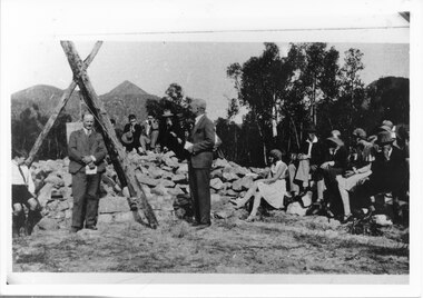
The photo shows the opening ceremony of Henham Township by Lord Stradbroke (the man on the right of the structure). A strip of land 2 kilometres long and half a kilometre wide had been approved as suitable for subdivision into 591 quarter acre blocks valued at 30-35 pounds each. Unfortunately it turned out to be a "fizzer". For further information see Victoria's Wonderland pp 93-95, 103.Photo shows a group of people sitting on and standing behind a low pile of rocks that sweeps around a wooden structure, which is three rough logs standing and lashed together to form a rough pyramid. A pulley is attached to the apex of the pyramid and a large stone block is suspended from it. Two men stand, one in front of and one beside the structure, both wear suits and are holding pieces of paper. A young boy sits in the left foreground in front of one of the poles.events, ceremonies -
 Halls Gap & Grampians Historical Society
Photograph - B/W, 14/04/1931
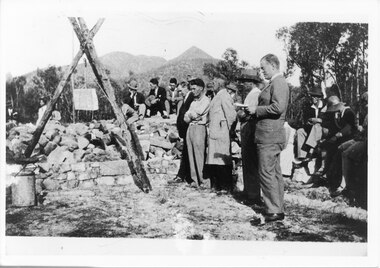
The photo shows the opening ceremony of Henham Township by Lord Stradbroke (the man on the right of the structure). A strip of land 2 kilometres long and half a kilometre wide had been approved as suitable for subdivision into 591 quarter acre blocks valued at 30-35 pounds each. Unfortunately it turned out to be a "fizzer". For further information see Victoria's Wonderland pp 93-95, 103.`Photo shows five men, middle foreground all standing, with others seated and standing in the background. The man stranding closest to the camera is holding a piece of paper in his hand. A rock pile and low stone fence can be seen middle foreground. A pulley is attached to a tripod of tree posts and is holding up a large cut stone. Mountains are visible in the background.events, ceremonies -
 Friends of the Cerberus Inc
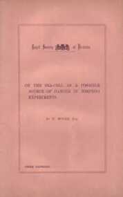
Sea-Cell Pamphlet, Henry Moors, On the Sea-Cell as a Possible Source of Danger in Torpedo Experiments, 1881
The Sea-Cell pamphlet was written by Captain Henry Moors of the Land Forces Signal & Torpedo Corps. In the pamphlet Captain Moors investigates the theory that the zinc case of the torpedo, the iron hull of Cerberus and the sea water combined to form a sea-cell. (battery) Captain Moors investigates whether this sea-cell could have resulted in a current being produced that was strong enough to detonate the torpedo.Eleven page pamphlet measuring 137 mm x 215 mm exploring the possibility that the Cerberus torpedo accident was caused by a Sea-Cell effect.sea-cell torpedo -
 Eltham District Historical Society Inc
Newsletter, Newsletter, No. 223 July 2015
Contents: • The Eltham Racing Club • July Meeting • July Excursion - Montmorency - the farm on the Plenty • Building and Completion of Saint Margaret's Church 1860-2014 by Geoff Sandy • Miss Bessie Wingrove - that Queer Creature Called a Land Lover by Maureen Jones • Eltham Avenue of Honour - Launch of New Markers by Jim Connor • Membership Subscriptions • ....and also • Contacts for the Eltham District Historical Society The Shire of Eltham Historical Society was formed in October 1967. The first newsletter of the Society was issued May 1978 and has been published continuously ever since on a bi-monthly basis. With the cessation of the Shire of Eltham in late 1994, the Society's name was revised to Eltham District Historical Society and this name first appeared with issue No. 103, July 1995. The collection of the Society's newsletters provides a valuable resource on the history of the Society's activities, office bearers and committee members, guest speakers and subjects of historical interest pertinent to the former Shire of Eltham and the Eltham District.A4 photocopied newsletter distributed to membersnewsletter, eltham district historical society, shire of eltham historical society -
 Eltham District Historical Society Inc
Negative - Photograph, St. Andrew's Hotel
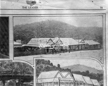
Queenstown (St. Andrews) District. Originally published in The Leader, Nov. 2nd, 1929, with the title "Relics of the Old Mining days in the Queenstown District," a series of eigth numbered photographs. 'The Leader'; a weekly journal of news, politics, agriculture, literature, science and sport. Shows a man on horseback and various people stand out the front with bush land in the background. In 1929, St Andrews was known as Queenstown.This photo forms part of a collection of photographs gathered by the Shire of Eltham for their centenary project book, "Pioneers and Painters: 100 years of the Shire of Eltham" by Alan Marshall (1971). The collection of over 500 images is held in partnership between Eltham District Historical Society and Yarra Plenty Regional Library (Eltham Library) and is now formally known as 'The Shire of Eltham Pioneers Photograph Collection.' It is significant in being the first community sourced collection representing the places and people of the Shire's first one hundred years.Digital image 4 x 5 inch B&W Negsepp, shire of eltham pioneers photograph collection, queenstown, st andrews hotel, st. andrews -
 Eltham District Historical Society Inc
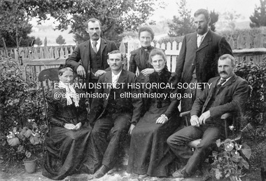
Photograph, Gulf Station, Yarra Glen. Members of the Bell Family, 1905c
Mrs Bell and her adult children of Gulf Station, Yarra Glen. Standing Jack (John), Jemima, Andrew. Seated Mary Ann (mother of all the others), Frank (Francis), Dinah and Bill (William). Scottish settlers Agnes and William Bell were the first to lease the land where the property was established in the 1850s. Gulf Station was farmed for nearly 100 years by the Bell family.This photo forms part of a collection of photographs gathered by the Shire of Eltham for their centenary project book,"Pioneers and Painters: 100 years of the Shire of Eltham" by Alan Marshall (1971). The collection of over 500 images is held in partnership between Eltham District Historical Society and Yarra Plenty Regional Library (Eltham Library) and is now formally known as 'The Shire of Eltham Pioneers Photograph Collection.' It is significant in being the first community sourced collection representing the places and people of the Shire's first one hundred years.Digital imagesepp, shire of eltham pioneers photograph collection, yarra glen, bell family, gulf station, dianah bell, frank bell, jack bell, jimima bell, mary ann bell, william bell -
 Federation University Historical Collection
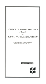
Programme, Release of Technology Park Plans and Laying of Foundation Stone, 1995, 02/1995
The Ballarat Technology Park site consists of 28.8 hectares of freehold land zoned for technology Purposes. The development plan for the Park was prepared by the City of Ballarat. The construction of the ISSC Southern Regional Data Centre was the first stage of the project. ISSC Southern Regional Data centre is a $12.5 million building development at the corner of Geelong Road and gear Avenue. The building was constructed by H. Troon Pty Ltd. White card program for the Release of Technology Park Plans and Laying of Foundation Stone. ballarat technology park, issc southern region data centre, troon, david james, geoffrey blainey, bruce clark, john bligh, roger hallam, campus plan -
 Ringwood and District Historical Society
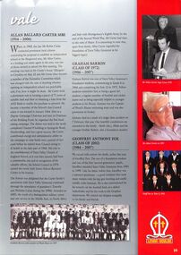
Print, Tribute to Allan Ballard Carter MBE (1924-2006) in the Yarra Valley Grammar , Kalinda Road, Ringwood, magazine
Allan Carter, Richard Carter's Father was a prominent business man and resident of Ringwood . The article describes how he was intrumental in obtaining the land for the school as one of the Formative Committee members. Also a member of the school's first Council and then the Chairman of the Building Fund. Richard Carter followed in his Father's footsteps in the Real Estate business. He was also the President of the Ringwood Historical Society for many years.Grey page with text and photographs torn from the school magazine. No date -
 City of Moorabbin Historical Society (Operating the Box Cottage Museum)
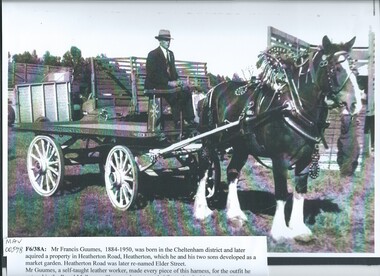
Photograph - Black & White, Mr F. Guumes 1884-1950 & Hand made Harness outfit c1947, c1947
Mr Francis Guumes1884-1950, was born in the Cheltenham district and later bought land in Heatherton Rd, Heatherton, where he and his two sons developed a market garden. Mr Guumes , a self taught leather worker, made every piece of this harness. He entered this outfit in the Royal Melbourne Show c1947 and was awarded 1st Prize in his section. ( H. Stanley 2005)Early settlers in Moorabbin Shire had to be resourceful and self sufficient as they developed market gardens and farms. The community learned to make, repair and invent tools and equipment that was needed on their properties. Black & White photograph, enlarged, showing Mr Francis Guumes, with the rig and leather work that he entered and won 1st prize in the Royal Melbourne Show c 1947guumes francis, royal melbourne show 1947, leatherwork, saddles, harness, draught horses, horse drawn carts, smith j l; smith mary ann, stanley helen, smith vic, , chaff cutter, horse drawn carts, toll gates brighton, motor cars 1900, steam engines, early settlers, bentleigh, mckinnon, parish of moorabbin, city of moorabbin, county of bourke, moorabbin roads board, shire of moorabbin, henry dendy's special survey 1841, were j.b.; bent thomas, o'shannassy john, king richard, charman stephen, highett william, ormond francis, maynard dennis, market gardeners, vineyards, orchards -
 City of Moorabbin Historical Society (Operating the Box Cottage Museum)
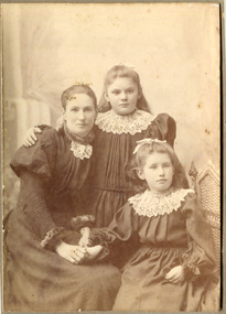
Photograph - Photograph, Mrs Carroll c1910, Mrs Carroll c1910, possibly c1910
Date unknown: Mrs Caroll and children. In 'Moorabbin A Pictorial History 1862 - 1994 ' by John Cribbin, The Carroll family migrated from Ireland and purchased land in the East Brighton ( now Bentleigh ) area of Henry Dendy's Special Survey 1841. Edward, J.W. & Daniel are shown in the Rate Book 1862 as owner occupiers and owner of property in Tuckers Road, Bryants Road and Centre Road.Photograph is black and white. There are three women in this photograph, a mother and her two children. The mother is sitting down on a chair to the left and her daughter sitting next to her, on the right (they are both holding hands), and her other daughter (child) right in between her mother and sister, with he arm around the mother's shoulder. All three of them are wearing their best dresses that have lace collars. As the clothes are similar to MAV Cat No. 00519 the photo may have been taken c 1910Front of Mount : Yeoman Co 287 Chapel St. Prahran, Victoria.children, chapel st, 287, prahran, carroll edward, carroll, j.w., carroll daniel, ireland, brighton, henry dendy's special survey 1841, market gardeners, pioneers, early settlers, dairy farmers, poultry farmers, bentleigh, mckinnon, ormond, prahran, yeoman photographers co. -
 Puffing Billy Railway
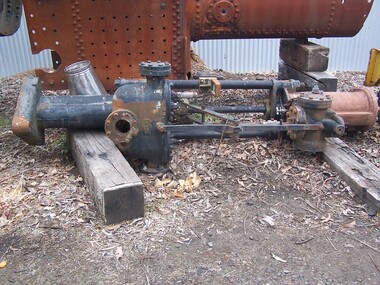
Weir Pump ( no. 2 ), Vertical ( no. 2 )
Weir Vertical Pump Weir Pumps - these types of vertical pumps were used extensively with both land and marine steam pumps. The pumps were also used for various duties from pumping oil fuel and feed water for boilers, to draining bilges on steam ship[s single cylinder, double acting vertical pumps used by G. & J. Weir Ltd. , of Cathcart, Glasgow .Weir Vertical Pump ( no. 2 ) - Steel vertical pumpWeirpuffing billy, fluid pump, weir, vetical pump -
 Wangaratta RSL Sub Branch
Framed Documents, Japanese Surrender - 9 September 1945
LIEUTENANT GENERAL (LT GEN) FUSATARO TESHIMA, COMMANDER-IN-CHIEF, JAPANESE SECOND ARMY, SURRENDERED TO GENERAL SIR THOMAS A. BLAMEY, COMMANDER-IN-CHIEF, ALLIED LAND FORCE, SOUTH WEST PACIFIC AREA. A SURRENDER CEREMONY WAS HELD ON SEPTEMBER 9 1945 AT 1 CORPS SPORTS GROUND ON MOROTAI. LT GEN TESHIMA WAS ACCOMPANIED BY CAPTAIN TOYIMA, WHO SIGNED FOR THE JAPANESE NAVY. The surrender of Imperial Japan was announced on August 15 and formally signed on September 2, 1945, bringing the hostilities of World War II to a close. There were a number of surrender ceremonies including Morotai on September 9 1945,Black plastic frame containing cream coloured paper documents x 3 on black background.Donated by Jean Hughes of Wangaratta on behalf of her husband ROWLAND J HUGHES VX 51510morotai, japanese surrender, ww2 -
 Wangaratta RSL Sub Branch
Photograph, c1944
RAVENSHOE, QLD. 1944-06-19. THE COMMANDER-IN-CHIEF, ALLIED LAND FORCES, SOUTH WEST PACIFIC AREA, VX1 GENERAL SIR THOMAS BLAMEY, GBE., KCB., CMG., DSO., ED., AND HIS STAFF WATCHING PERSONNEL OF HEADQUARTERS COMPANY, 2/24TH INFANTRY BATTALION ENGAGED IN THEIR 3" MORTAR DRILL DURING HIS TOUR OF INSPECTION OF ARMY UNITS IN THE ATHERTON AREAThe 2/24th Battalion was an infantry battalion of the Australian Army, which served during World War II .A unit of all-volunteers, it was formed in July 1940 from primarily Victorian volunteers and was known as "Wangaratta's Own" because of the time the battalion spent in the town during its formative period prior to deployment overseas. It served in North Africa in 1941–1942 as part of the 26th Brigade, which was assigned to the 7th Division, before being reassigned to the 9th Division. In early 1943, the battalion returned to Australia and later took part in campaigns against the Japanese in New Guinea in 1943–1944 and Borneo in 1945, before being disbanded in 1946. The 2/24th suffered the highest number of casualties of any 2nd AIF infantry battalion. The Unit was granted the Freedom of the City by the Rural City of Wangaratta in 1990 and one of the first, if not the first, to receive this type of honourReproduced black and white photograph of soldiers and Army Officer watching on as two soldiers in foreground demonstrate equipment2/24th battalion, ww2, ravenshoe, blamey -
 Lake Bolac & District Historical Society
Black and white photograph, E & M Rowley, pioneers at Lake Bolac, 1862
Edward and MaryAnn Rowley were pioneer settlers at Lake Bolac, taking up land in 1862. Their children were Sarah, Elizabeth, Maryanne, Deborah, Emily, Ellen, Eliza, Emma, Martha and Edward. The change-over station for stage coaches, including Cobb and C., and paddocks for resting horses, were on their property. The farm was later bought by J.T. Murray. The family are interred in the Lake Bolac Cemetery.lake bolac, rowley, pioneer settlers, 1862, murray, cobb and co. -
 Hume City Civic Collection
Photograph
'Glenara' is situated along the Deep Creek at Bulla and was built on an original government grant of land by Walter Clark. His fourth child, Alistair, spent much of his life there and with the help of his gardener, W.Peers, gained world recognition for introducing 150 new rose species which included the Black Boy and Lorraine Lee. He was also founder of the Moonee Valley Racing Club.A black and white photograph of a Victorian home with a return verandah across the front and side. Vines are growing up the metal verandah posts and across the front of the verandah.glenara', rose gardens, roses, clark, alistair, walter, moonee valley racing club, george evans collection -
 Hume City Civic Collection
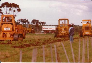
Photograph, 1/08/1978
On 4th of August 1978 work began on the construction of the Goonawarra Estate on land that was the former Goonawarra Farm which overlooked the town of Sunbury abnd the Jacksons Creek valley. Plans for the new development included a golf course, houses, community and recreational facilities.The golf course openrd in 1980 and housing construction continued throughout the last two decades of the twentieth century and into the twentieth first century.A coloured photograph of the first sod being turned at the Goonawarra Estate. Four large pieces of earth-moving machinery and a large semi-trailer are in picture. A man is standing in the foreground.goona warra golf club, goonawarra farm, goonawarra housing estate, housing developments, sharkey, robert b., killkenny homes, australian ideas homes pty.ltd., craftsmen homes., glamor homes, villa bella homes, george evans collection -
 Stawell Historical Society Inc
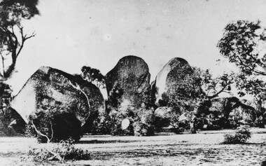
Photograph, Sister Rocks looking North c1860's
Sister Rocks. Looking North c1860's. This photo is of a well known land mark along the Western Highway. They take their name from 3 sisters named Levy, who camped there with their parents during the early days of Stawell. In 2011 photos were taken to update and add to our "Sister Rock" collection. Direction of photos has been identified and are catalogued as on the updated index card. Black & White print of a photograph depicting large granite boulders with trees in foreground. c1900Looking North from Western Highwaystawell scenery -
 Whitehorse Historical Society Inc.
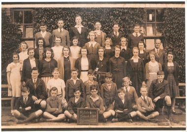
Photograph - Large sepia photo, Mitcham State School 1937
1888 school opened. 1890 children attend (50ft x 20ft room. 90 children, 3 teachers)1922 land purchased on Tirana St. site. 1930 brick building built for upper grades. 1950's timber rooms added, later burnt down. 1967 Junior classes to brick extension Tirana St. 2008 2 large learning spaces built.Sepia photograph of Mitcham school (Grade 7 and 8) taken outside in front of a plant covered wall. The photograph was taken in 1937. This is a class of 37 children. Teacher on the right.mitcham state school no 2094, class photo, 1937 -
 Sunbury Family History and Heritage Society Inc.
Photograph
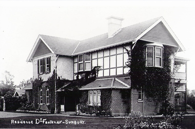
The house, known as 'Ardcloney' was built by Dr. Faulkner in 1911. The land on which it is built was The Dell which was previously owned by Mr. Austin. Dr. Faulkner had a medical practice in Sunbury in until his death in 1922 when he was run over by a train while holidaying in Adelaide. Over the years the mansion has had a number of owners and today it functions as a day hospital for Sunbury residents.A dark sepia photograph with a cream border of a two storey Californian Bungalow style building seat in a large garden.RESIDENCE DR. FAULKNER - SUNBURYardcloney -
 Sunbury Family History and Heritage Society Inc.
Photograph, St. Mary's Anglican Church, Pre1910
This is an early photograph of St. Mary's Anglican Church in Sunbury. On 13th October 1863, the Government granted one acre of land on the corner of Stawell and O'Shanassy Streets for the building of a church. he first service was held on 24th November 1867. After that date subsequent additions were made. The gas lamp outside the church indicates that the photograph was taken before electric power was installed in Sunbury. St. Mary's Anglican Church is one of the earliest places of worship to be built in Sunbury.A non-digital sepia post card photograph of a small bluestone church with a slate roof with a wooden picket fence and two gates across the front. A gas lamp is on the pathway. Peter Collett's signature is on the back as well as a sticker with number 7 written on itst. mary's church of england., o'shanassy street, stawell street -
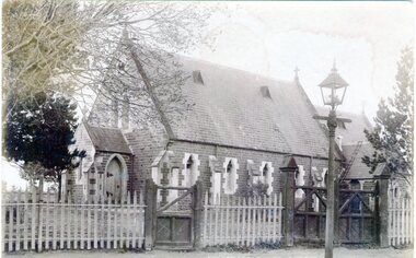
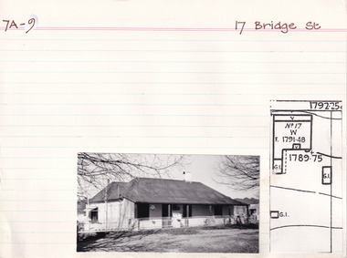 The Beechworth Burke Museum Research Collection
Card (Series) - Index Card, George Tibbits, 17 Bridge Street, Beechworth, 1976
George Tibbits, University of Melbourne. Faculty of Architecture, Building and Town & Regional PlanningIndex system that support the research for Beechworth : historical reconstruction / [by] George Tibbits ... [et al]Arranged by street names of BeechworthEach index card includes: street name and number of property, image of property, allotment and section number, property owners and dates of ownership, description of the property according to rate records, property floor plan with dimensions.beechworth, george tibbitsbeechworth, george tibbits -
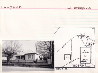 The Beechworth Burke Museum Research Collection
Card (Series) - Index Card, George Tibbits, 26 Bridge Street, Beechworth, 1976
George Tibbits, University of Melbourne. Faculty of Architecture, Building and Town & Regional PlanningIndex system that support the research for Beechworth : historical reconstruction / [by] George Tibbits ... [et al]Arranged by street names of BeechworthEach index card includes: street name and number of property, image of property, allotment and section number, property owners and dates of ownership, description of the property according to rate records, property floor plan with dimensions.beechworth, george tibbitsbeechworth, george tibbits -
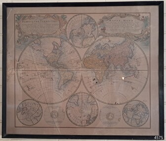 Flagstaff Hill Maritime Museum and Village
Map - World Map, Mappe Monde [Medieval Map of the World], 1910
This map from the mid-18th century doesn't include the finer details of land and sea masses that we know today. The map was produced by German cartographer and publisher, Johann Baptist Homann (1663-1724) and published in 1746, after his death. Earlier versions were published, such as 1707 and 1716. The date can be calculated from the Roman numerals on the top left text area. This print of a map is significant for its connection with early world explorers. A comparison of maps over the centuries shows the progression of navigational technology, the countries who claimed the land they explored. The naming of even some Australian locations shows who had already made their mark on Australia in the early 18th century. The print shows the fine details included by the cartographer and the beauty included that makes it attractive and interesting even today. The map is also significant for its connection with German cartographer, Johann Baptist Homann, whose Homann publishing company was renewed in Germany for producing high quality maps and atlases. Map behind glass in dark brown wooden frame on beige paper. The Coloured hand drawn line drawings show different hemispheres of the known world in the mid-18th century. Beautifully drawn figures and decorative embellishments enhance the map. The text on the top right has an explanation of the Figures I, II, III, and IV. This print of the 1746 map was produced in England by Leisure Arts Ltd. "PLANIGLOBIL TERRESTRIS" "MDCCXXXXVI" [1746] "MAPPE_MONDE" [Medieval Map of the World] "LEISURE ARTS LTD" "Printed in England"flagstaff hill, warrnambool, flagstaff hill maritime museum, flagstaff hill maritime village, flagstaff hill maritime museum and village, shipwreck coast, world map, french map, 18th century map, leisure arts ltd, cartography, early exploration, cartographer, johann homann (1663-1724), exploration, naviagtion, 1746 planiglobil terrestris -
 Bendigo Military Museum
Photograph - RA Svy Project C4 Aerodist Operation, Eastern Arnhem Land, NT, 1967
This is a set of 30 photographs of Royal Australian Survey Corps (RA Svy) personnel from Central Comd Fd Svy Unit (Adelaide) on Aerodist survey operation - Project C4 in Eastern Arnhem Land, Northern Territory in 1967. Photos of personnel were taken either at the operations base at Numbulwar or the main base at Gove (Nhulunbuy). RA Svy conducted nineteen Aerodist operations for 12 years from 1964 to 1975. Aerodist MRC2 was a tellurometer-based system adapted for aircraft to accurately measure distances between non-intervisible ground survey stations, using the aircraft as an intermediate station. Lower order geodetic results could be achieved by survey network trilateration. The measured distances between stations formed survey networks from which each station’s latitude and longitude was computed. Aerodist MRC2 was RA Svy’s major horizontal control survey tool for mainly medium scale topographic mapping (scale 1:100,000 Class A being spatially accurate to within 50 metres) in PNG, northern NT, north-west WA, Kalimantan Barat (West) Indonesia, Sumatra Indonesia, Gulf of Carpentaria and Cape York, QLD. In 1967, the Aerodist MRC2 Master equipment was installed in the aircraft featured in this set of photos, Executive Air Services’ (Essendon VIC) Grand Aero Commander VH-EXX. It was the same aircraft type and company contracted to Division of National Mapping for Aerodist MRC2 surveys. From July to October 1967 the aircraft was attached to Central Comd Fd Svy Unit (Adelaide - Major Don Ridge) on Project C4 eastern-Arnhem Land NT, where 317 Aerodist lines measuring 17,300 line miles were successfully completed. This was the most productive Aerodist project thus far. The most common helicopter used by RA Svy up to 1972 was the civilian Bell 47G-2 and the Sioux Light Observation Helicopters (LOH), the Australian Army’s equivalent featured in this photo set. These light observation helicopters had a limiting load carrying capacity of up to about 500 pounds. By comparison, one Aerodist team including two people weighed up to 1,500 pounds. Source: Royal Australian Survey Corps – Aerodist Years 1964-1975 by Peter Jensen. This is a set of 30 photographs of Royal Australian Survey Corps (RA Svy) personnel on Aerodist survey operations in Eastern Arnhem Land, Northern Territory in 1967. The photographs are on 35mm negative film and scanned at 96 dpi. They are part of the Army Survey Regiment’s Collection. .1) to .4) - black & white, 20th August 1967, Project C4 Aerodist Operations Base - Numbulwar, NT. .5) - Photo, black & white, 1967. Probable wrecked Indonesian fishing vessel. .6) to .8) - Photo, black & white, 1967. Unidentified survey operations base, L to R: unidentified personnel. .9) - Photo, black & white, 1967. Unidentified survey operations base, unidentified soldier driving a Haflinger 4x4 Light utility vehicle. .10) - Photo, black & white, 1967. Unidentified survey operations base, L to R: unidentified technician. .11) - Unidentified technician reading two survey altimeters to compute corrections to the measured distances for atmospheric refraction and to compute the sea level distances from the slope distances aircraft to the ground stations. .12) - Photo, black & white, 1967. Unidentified survey operations base, L to R: unidentified personnel. .13) to .16) - Photo, black & white, 1967. Unidentified personnel operating remote Aerodist MRC2 ground instruments. .17) to .18) - Photo, black & white, 1967. Unknown RA Svy office location. .19) to .20) - Photo, black & white, 1967. Aerodist MRC2 Master equipment. .21) to .22) - Photo, black & white, 1967. Aero Commander VH-EXX probably at Gove, NT, Central Comd Fd Svy Unit (Adelaide) – OC Major Don Ridge. .23) to .25) - Photo, black & white, 1967. Aero Commander VH-EXX probably at Gove, NT. Unidentified personnel. .26) - Photo, black & white, 1967. Aero Commander VH-EXX probably at Gove, NT. Aerodist antenna pods are visible on the aircraft. .27) to .29) - Photo, black & white, 1967. Australian Army Sioux Light Observation Helicopter (LOH) probably at Gove, NT. .30) - Photo, black & white, 1967. Panelled U337 survey station, visible as a white cross on aerial identification photo..1P to .2P – date and location on edge of film negative. .5P to .28P – no annotations .29P - annotated in white ‘RW-JEP Gove NT’ .30P - annotated in white ‘U337 Spool No1 Jun67’royal australian survey corps, rasvy, army survey regiment, army svy regt, fortuna, asr, aerodist, surveying, central comd fd svy unit -
 The Beechworth Burke Museum Research Collection
Card - Index Card, George Tibbits, Ford Street, Beechworth, 1976
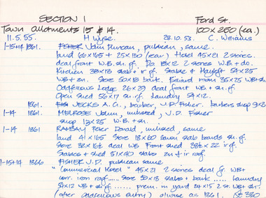
Property - Ford Street Beechworth - Section 1, Town Allotment 14 & 15 - 100' x 250' each Ownership details and history - 28 Oct 1853 - C. Williams - 11 Nov 1855 - H. Wyse 1-15&14 - 1861 - Fisher, John Duncan - publican, same. Land 66'x165' + 25'x130' (rear) Hotel 45'x21' 2 stories, deal front WB. sh. rf. Do 18'x12' 2 stories WB & Do. Kitchen 38'x13' slab + ir rf. Stable & Hayloft 54'x25' WB & sh. Store 50'x18' bark. Billiard room 35'x25' WB + sh. Oddfellows Lodge 26'x29' deal front WB + sh. rf. Open shed. 56'x17' sh. rf. Laundry 54'x12'. 1861 - Jecks A.G. barber, J.D. Fisher barbers shop 9'x8' 1-14 - 1861 - Melrose, John, unlisted J.D. Fisher shop 13'x25' WB + sh. 1-14 - 1861 - Ramsay, Peter Donald, unlisted, same, land 41'x165' store 18'x60' sawn slab boards sh. rf. store 32'x 16'6"deal WB Front Shed 38'6"x 22' ir rf. 1-15+14 - 1863/4 J.D. Fisher, Hotel as 1861 except store 50'x18' is detached and a shop above De Jecks & Kaliton of a 2 storey residence. 1863/4 - Jecks as above 1-14 - 1863/4 Ramsay - as 1866 1-14 - 1866 - Fisher J.D. - publican, same, "Commercial Hotel" 45'x21' 2 stories deal fr. WB+ corr. Iron roof..... store 50'x18' slabs + bark .... laundry 54'x12' WB + sh. rf. ..... prem. in yard 24'x15' 2 stories WB = sh. (after Oddfellows entry) 0/wise as 1861. £330 1-14 - Jecks A.G. barber, J.D. Fisher, barbers shop 9'x8' £28 1-14 - 1866 - Muirhead, George, Tailor, J.D.Fisher prem 13'x12' WB + Sh. £26 1-14 - 1866 - Ramsay P.D. Spirit dealer, same land 41'x165' front prem 23'x54' bk & ir. rf. Do in rear 32'x16'6" deal fr. WB + sh. rf. Do 8'x8' do---do. Stables + shed 51'x40' slabs, sh+ir. rf. (as1861) £35 1-15+14 1871 - Tanwell, Thomas, publican, same - Hotel as above except. Kitchen 40'x15' bk+iron roof as 1863/4 1861 1-14 - 1871 - Jecks, A.G., T. Tanswell, shop 11'x9' £15 1-14 - 1871 - Goodwin, George, watchmaker, T. Tanswell, sh. 12'x11' £19 [these two were actually entered before 1-14+15] 1-14 - 1871 - Scott, Robert, Wine & Spirit Merchant, P.D. Ramsay land 41'x165' deal fr. WB + sh. rf. Stable & shed 51'x40' slabs + iron roof. 1-15+14 - Tanswell, Thomas, publican, same, land 66'x135' + 25'x130' Hotel front buildings. 65'x35' brick, Back do. 42'x30' brick 2 stories iron roof. Kitchen 40'x15' bk. iron roof. Club room 26'x29' WB. sh. rf. Billiard room 35'x25' WB ir. rf. Prem in yard 24'x15' 2 stories WB sh. rf. Laundry 54'x12' WB sh. rf. Store 50'x18' slabs bark rf. Stables 54'x25' WB sh. rf. Shed 56'x17' £250 1-14 - 1876 - Jecks, A.G. barber T. Tanswell shop £15 1-14 - 1876 - Tanswell, T. publican, same, shop & room in rear £20 1-14 - 1876 - Crawford, Hiram Allen, Connelly, Michael, coach proprietors, Beechworth U.S. Council. Weighbridge £10 1-14 - 1876 - Crawford & Connolly, as above, T. Tanswell. prem as 1871. "23'x55'" & no deal fr. ou prem in rear £52 1-15+14 - 1884 - Tanswell E. Tanswell T. Hotel as above, hotel, billiard clubrooms etc. 1-14 - 1884 - Crawford H.A. - Jackson P.W. - McCurdy W. coach props., B.U.S.C., Weighbridge 1-15+14 - 1884 - Crawford H.A. coach props, T. Tanswell, Commercial stable (at rear) 1-14 - 1884 - Crawford H.A. coach prop, same, office, store, cellar & prem. 1-15+14 - 1889 - Tanswell, Edward. Hotel keeper, T. Tanswell, Comm Hotel Billiard Club + sample rooms, prem + land £175 1-15+14 - 1889 - Crawford, H.A. - Connolly, Thomas - McCurdy, William, coach props, same, Stables, Coach sheds, prems + land £80 1-14 - 1889 - Crawford & Co Ltd., coach props, T. Tanswell, office, store, prem + land £50 1-14 - 1889 - As above. B.U.S.C. Weighbridge £10 1-15+14 - 1900 - Crawford & Co ltd. coach proprietors, excecutors of Tanswell's, stables, offices, coach sheds, factory, land £130 1-15+14 - 1906 - Tanswell, Jane, hotelkeeper, same, hotel, prem + land £150 1-15+14 - 1906 - Tanswell, Jane, Clubrooms, Comm. Hotel £20 1-15+14 - 1906 - Crawford & Co LTD. coach props, Jane Tanswell, stables offices, coach sheds, factory + land £85 Architectural Index Card - Brian Pump and Tony Dugan - Photographers beechworth, george tibbits -
 Eltham District Historical Society Inc
Document - Newspaper clipping, "The lap of luxury; Blending into Eltham environ", Property Age, The Age, Wednesday 24 June 1998, p5, June 1998
Both of the architects involved in the 2.4-hectare Kinloch Gardens parkland development in Arthur Street, Eltham, are now living on the estate. The project was conceived by Eltham architect Ian Jelbart, whose family has owned the land for more than 100 years, and fellow architect Graeme Gunn, who in the 1960s was one of the creators of the Merchants Builders concept that set new trends in Melbourne housing. The $5 million project is based around two of the original buildings, on what was once a 100-hectare farm owned by the Jelbart family. Ian Jelbart always intended to continue living in the original homestead building, and now Graeme Gunn has moved into the big residence that once was the barn. Kinloch Gardens is designed to combine the more manageable land sizes increasingly demanded by buyers with ample "internal space, flexible floorplans, privacy and individuality of designs. Individual houses are placed on small separate allotments around an area of private parkland. The aim is to ensure total privacy, offer virtually unlimited views and parkland vistas, and remain aesthetically compatible with the local environment. Homes in four basic designs over either two or three levels are being sold off the plan, with prices ranging from the high $200,000s to the high $300,000s. Two have already been sold. Indication of land-only values The prices being asked for some vacant blocks offered for private sale provides an enlightening comparison of the relative "land only" values for homes sites in various areas. A 751 sq metre block on a new residential estate in Bentleigh/Carnegie is offered at $235,000, equivalent to $312/square metre; while in Merrett Drive, Williamstown, a 561 sq metre allotment offered for $169,000 carries a rate of $301/sq metre. In Barnsbury Road, Balwyn, the $450,000 price tag on a 584 sq metre allotment equates to $770 sq metre; and in York Street, Richmond, a 198 sq metre postage stamp is priced at $230,000 or $1162/sq metre. - Rex BookerDigital file only; created from scan undertaken by EDHS of item on loanarthur street, eltham, graeme gunn, houses, ian jelbart, jelbart property, kinloch gardens, rob maclellan, robert marshall, woodridge estate