Showing 7089 items matching "snowy-river"
-
 Greensborough Historical Society
Photograph - Digital Image, Pioneer descendants, 28/3/2009
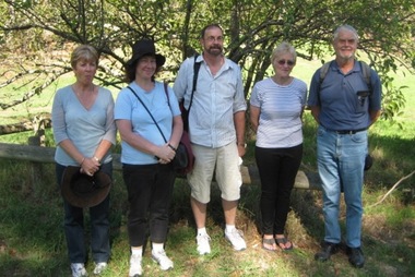
Photograph of descendants of the Whatmough family. The Whatmoughs settled and farmed along the Plenty River in Greensborough. Pictured are Denise Anderson and sister Barbara, Steve Whatmough, Faye Fort (nee Partington) and Brian Poulter. Photograph taken at the unveiling of a plaque at the site of "Happy Hollow".Digital copy of colour photograph.happy hollow, poulter, partington, whatmough -
 Greensborough Historical Society
Photograph - Digital Image, Blackjack, 1954_
Blackjack. The Blackjack property, house and acres of fruit orchards ran down to the Plenty River off Hume Street Greensborough and was the home of the Robinson family to late 1956. The photographs were taken as slides by Frank Robinson and digitised by his son James in 2015.Digital copy of colour photograph.robinson family, blackjack -
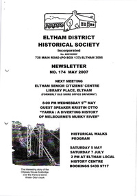 Eltham District Historical Society Inc
Newsletter, Newsletter, No. 174 May 2007
Contents: • Next meeting, guest speaker; Kristin Otto: Yarra; A Diverting History of Melbourne’s Murky River • May Meeting • President’s Report • Pat Baddeley’s Story (continued) • Fortieth Anniversary Celebrations • Office Bearers 2007-8 • Subscriptions • Other News The Shire of Eltham Historical Society was formed in October 1967. The first newsletter of the Society was issued May 1978 and has been published continuously ever since on a bi-monthly basis. With the cessation of the Shire of Eltham in late 1994, the Society's name was revised to Eltham District Historical Society and this name first appeared with issue No. 103, July 1995. The collection of the Society's newsletters provides a valuable resource on the history of the Society's activities, office bearers and committee members, guest speakers and subjects of historical interest pertinent to the former Shire of Eltham and the Eltham District.A4 photocopied newsletter distributed to membersnewsletter, eltham district historical society, shire of eltham historical society -
 Kiewa Valley Historical Society
Photos - SECV Gateway at Mt Beauty to the High Plains and x2 Mt Beauty Camp Extensions
There were two gateways at Mt Beauty. One at the West Kiewa River closing off entry to Mt Beauty township and another leading to the High Plains from Mt Beauty. These were put in by the SECV to control operations for the Kiewa Hydro Electric Scheme.Black and white photos - A. Gateway at Mt Beauty to the Bogong High Plains. B. a panorama photo of the Mt Beauty Camp Extensions 1950 taken in two shots thus spitting the middle photo.mt beauty gateway, mt beauty camp extensions -
 Eltham District Historical Society Inc
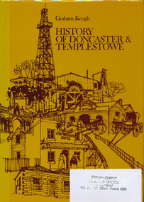
Book, City of Doncaster and Templestowe, History of Doncaster & Templestowe by Graham Keogh, 1975
History of the City of Doncaster and Templestowe, beginning with first settlers on Bulleen and Templestowe rivers, including gold seekers, general development 1900-1945, expansion, road problem, disaster of 1962, traffic problems, Warrandyte State Park, historical research. photos index466 p.ISBN 0959948716doncaster, templestowe, bulleen, warrandyte -
 Eltham District Historical Society Inc
Photograph, Main Road-Fitzsimons Lane Roundabout, c. Oct 1987, 1987
Fitzsimons Lane was originally known as the Eltham-Templestowe Road north of the Yarra and Fitzsimons Lane south of the Yarra River. Date based on other similar display panels visible in images of the Shire of Eltham display at the Eltham Community Festival, 7 November 1987Colour photographdisplay panel, eltham festival, infrastructure, shire of eltham, main road, roundabouts, fitzsimons lane -
 Bendigo Historical Society Inc.
Photograph - Historical Society Field Trip to Coliban Water Assets, Dec 2009
The original Coliban Water Works were designed in 1863 by the Irish engineer Joseph Brady. The system included 70 kilometres of open water channels, aqueducts, syphons and tunnels to carry water (by gravity) from the Coliban River at Malmsbury, north to Castlemaine and Bendigo.One hundred and nineteen photos taken on a field trip by the Bendigo Historical Society to Coliban Water Supply assets.history, bendigo, coliban water, joseph brady, irrigation -
 Hume City Civic Collection
Photograph, c. 1870s - 1880s
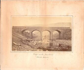
The phtograph was taken by Alfred Sinel who was the local photgrapher in Sunbury. The four arched bridge spans the river at Deep Creek, Bulla. The bridge replaced the forde crossing which is in the foreground of the photograph. Alfred Sinel is listed in the 1874 rate book as a photographer - artist.A mounted sepia photograph of the four-arched bluestone bridge over Deep Creek at Bulla. A man is standing under the 3rd arch from the LHS. The cream mount has a ruled ink frame around the photo. The caption has been hand-written under the photograph.BRIDGE OVER THE DEEP CREEK / BULLA BULLAdeep creek, bridges, bulla, sunbury, sinel, alfred, photographers, george evans collection -
 Hume City Civic Collection
Photograph, Early 1970s
The Kaolin Quarry at Bulla supplied Kaolin to the Northcote and Brunswick Pottery Works until it ceased operation at that site in the 1950s. The three arched bluestone bridge r3placed a ford crossing across Deep Creek, which along with Jacksons Creek flows into the Maribyrnong River.A black and white photograph of the Deep Creek and three arched bluestone bridge in the Bulla Township with the Kaolin Quarry in the background. One truck is crossing the bridge with a tanker approaching the bridge at the bottom of the Bulla Hill.deep creek, bridges, kaolin quarries, quarries, george evans collection -
 Port Melbourne Historical & Preservation Society
Pamphlet - The Pubs of Port 2001, Pat Grainger, Walks around Vintage Port No.6, 2001
Update and reprint of Pubs in Port Walk (No 7). Project Assisted by CoPP. The original Pubs in Port Walk was No 7 with No 6 reserved for Bend on the River: Westgate Park. The Westgate Park walk was not produced so on this updated version the Pub walk became No 6.Port Melbourne Historical and Preservation Society publication, "Walks around Vintage Port", "No.6 Pubs of Port" 2001 Edition.built environment - commercial, business and traders - hotels -
 Greensborough Historical Society
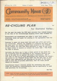
Newsletter, Greenhills and North Greensborough Progress Association, Community News: official journal of the Greenhills and Nth. Greensborough Progress Association. 27th June, 1973. Edition No. 5/73, 27/06/1973
This edition includes a report on the Progress Association's June 1973 meeting, Councillor's report, Re-cycling Plan for Diamond Valley, Diamond Valley Repertory, Eltham Film Society, School and Kinder news, The Plenty River: Fricker Avenue Reserve, Open forum,.Newsletter, 24 p., illus.greenhills and north greensborough progress association, greenhills -
 The Beechworth Burke Museum
Photograph
Taken on 25 October 1930, various houses with the Hume Dam under construction are depicted in the background. The construction of the Hume Dam took place from 1919 to 1936. At the time of construction, it was the second largest dam in the world. It was also one of the earliest civil projects developed after the Federation. Some of the Dam workers consisted of World War I veterans. Dam workers often settled their families in Mitta Junction Village and Wodonga. Archaeological surveys were completed by Austral Archaeology, which was done when the Department of Land & Water Conservation was doing work to improve Hume Dam. The archaeological report that came out of the survey recommended three sites of interest where archaeological excavation should be done: Camp Ganger’s Quarters, Stableman’s Quarters, and the Industrial Dump. The excavation uncovered artefacts. Mitta Mitta: Mitta Mitta is situated between Mount Welcome and Mount Misery. It is named after the river that explorers Hume and Hovell discovered in 1824. The town would eventually become a huge gold mining town. Mitta Mitta is called Midamodunga by the local Indigenous peoples Wodonga: Wodonga is situated on the Murray River and is part of North East Victoria. Hume and Hovell: Hamilton Hume (1979-1873) and William Hilton Hovell (1786-1875). W. H. Hovell was born in Norfolk England and Hume was born in Parramatta, New South Wales Hovell and Hume undertook an exploration journey in 1824 and thought they discovered a river, which turned out to be the Murray River. They returned home in 1825, but returned to the area in 1826 and discovered coal in the area. This photo is historically significant as it shows the Hume Dam under construction in 1930. The Dam was named after Hamilton Hume, who is an important historical figure for this area as he helped discover the area where resources were found.Sepia rectangular photograph printed unmountedReverse: 84-19-5 / 1997.3185/ Values & spillway. / When completed the wall / will be as high as the / scaffolding. [featuring trademark: kodak print]construction, houses, veterans, mitta junction village, hume dam, world war i, federation, wodonga, archaeological survey, excavation, austral archaeology, department of land & water conservation, camp ganger's quarter's, stableman's quarters, industrial dump, artefacts, mitta mitta, mount welcome, mount misery, murray river, hamilton hume, william hilton hovell, hume and hovell expedition -
 The Beechworth Burke Museum
Photograph, c1930
Taken on 25 October 1930, various houses with the Hume Dam under construction are depicted in the background. The construction of the Hume Dam took place from 1919 to 1936. At the time of construction, it was the second largest dam in the world. It was also one of the earliest civil projects developed after the Federation. Some of the Dam workers consisted of World War I veterans. Dam workers often settled their families in Mitta Junction Village and Wodonga. Archaeological surveys were completed by Austral Archaeology, which was done when the Department of Land & Water Conservation was doing work to improve Hume Dam. The archaeological report that came out of the survey recommended three sites of interest where archaeological excavation should be done: Camp Ganger’s Quarters, Stableman’s Quarters, and the Industrial Dump. The excavation uncovered artefacts. Mitta Mitta: Mitta Mitta is situated between Mount Welcome and Mount Misery. It is named after the river that explorers Hume and Hovell discovered in 1824. The town would eventually become a huge gold mining town. Mitta Mitta is called Midamodunga by the local Indigenous peoples Wodonga: Wodonga is situated on the Murray River and is part of North East Victoria. Hume and Hovell: Hamilton Hume (1979-1873) and William Hilton Hovell (1786-1875). W. H. Hovell was born in Norfolk England and Hume was born in Parramatta, New South Wales Hovell and Hume undertook an exploration journey in 1824 and thought they discovered a river, which turned out to be the Murray River. They returned home in 1825, but returned to the area in 1826 and discovered coal in the area.This photo is historically significant as it shows the Hume Dam under construction in 1930. The Dam was named after Hamilton Hume, who is an important historical figure for this area as he helped discover the area where resources were found.Sepia rectangular photograph printed unmountedReverse: 84-19-2/ 1997.3188/ These are the four / release valves they are / not always open (illegible) this / when closed the water flows / over the spillway. [featuring trademark: kodak print] photograph number: 354construction, houses, veterans, mitta junction village, hume dam, world war i, federation, wodonga, archaeological survey, excavation, austral archaeology, department of land & water conservation, camp ganger's quarter's, stableman's quarters, industrial dump, artefacts, mitta mitta, mount welcome, mount misery, murray river, hamilton hume, william hilton hovell, hume and hovell expedition -
 The Beechworth Burke Museum
Photograph, 25 October 1930
Taken on 25 October 1930, various houses with the Hume Dam under construction are depicted in the background. The construction of the Hume Dam took place from 1919 to 1936. At the time of construction, it was the second largest dam in the world. It was also one of the earliest civil projects developed after the Federation. Some of the Dam workers consisted of World War I veterans. Dam workers often settled their families in Mitta Junction Village and Wodonga. Archaeological surveys were completed by Austral Archaeology, which was done when the Department of Land & Water Conservation was doing work to improve Hume Dam. The archaeological report that came out of the survey recommended three sites of interest where archaeological excavation should be done: Camp Ganger’s Quarters, Stableman’s Quarters, and the Industrial Dump. The excavation uncovered artefacts. Mitta Mitta: Mitta Mitta is situated between Mount Welcome and Mount Misery. It is named after the river that explorers Hume and Hovell discovered in 1824. The town would eventually become a huge gold mining town. Mitta Mitta is called Midamodunga by the local Indigenous peoples Wodonga: Wodonga is situated on the Murray River and is part of North East Victoria. Hume and Hovell: Hamilton Hume (1979-1873) and William Hilton Hovell (1786-1875). W. H. Hovell was born in Norfolk England and Hume was born in Parramatta, New South Wales Hovell and Hume undertook an exploration journey in 1824 and thought they discovered a river, which turned out to be the Murray River. They returned home in 1825, but returned to the area in 1826 and discovered coal in the area.This photo is historically significant as it shows the Hume Dam under construction in 1930. The Dam was named after Hamilton Hume, who is an important historical figure for this area as he helped discover the area where resources were found.Sepia rectangular photograph printed unmountedReverse: 84-19-6/ 1997.3187/ The spillway [featuring trademark: kodak print] construction, houses, veterans, mitta junction village, hume dam, world war i, federation, wodonga, archaeological survey, excavation, austral archaeology, department of land & water conservation, camp ganger's quarter's, stableman's quarters, industrial dump, artefacts, mitta mitta, mount welcome, mount misery, murray river, hamilton hume, william hilton hovell, hume and hovell expedition -
 The Beechworth Burke Museum
Photograph, 25 October 1930
Taken on 25 October 1930, various houses with the Hume Dam under construction are depicted in the background. The construction of the Hume Dam took place from 1919 to 1936. At the time of construction, it was the second largest dam in the world. It was also one of the earliest civil projects developed after the Federation. Some of the Dam workers consisted of World War I veterans. Dam workers often settled their families in Mitta Junction Village and Wodonga. Archaeological surveys were completed by Austral Archaeology, which was done when the Department of Land & Water Conservation was doing work to improve Hume Dam. The archaeological report that came out of the survey recommended three sites of interest where archaeological excavation should be done: Camp Ganger’s Quarters, Stableman’s Quarters, and the Industrial Dump. The excavation uncovered artefacts. Mitta Mitta: Mitta Mitta is situated between Mount Welcome and Mount Misery. It is named after the river that explorers Hume and Hovell discovered in 1824. The town would eventually become a huge gold mining town. Mitta Mitta is called Midamodunga by the local Indigenous peoples Wodonga: Wodonga is situated on the Murray River and is part of North East Victoria. Hume and Hovell: Hamilton Hume (1979-1873) and William Hilton Hovell (1786-1875). W. H. Hovell was born in Norfolk England and Hume was born in Parramatta, New South Wales Hovell and Hume undertook an exploration journey in 1824 and thought they discovered a river, which turned out to be the Murray River. They returned home in 1825, but returned to the area in 1826 and discovered coal in the area.This photo is historically significant as it shows the Hume Dam under construction in 1930. The Dam was named after Hamilton Hume, who is an important historical figure for this area as he helped discover the area where resources were found.Black and white rectangular photograph printer unmountedReverse: 84-20-1/ 1997.3147construction, houses, veterans, mitta junction village, hume dam, world war i, federation, wodonga, archaeological survey, excavation, austral archaeology, department of land & water conservation, camp ganger's quarter's, stableman's quarters, industrial dump, artefacts, mitta mitta, mount welcome, mount misery, murray river, hamilton hume, william hilton hovell, hume and hovell expedition -
 The Beechworth Burke Museum
Photograph, 25 October 1930
Taken on 25 October 1930, various houses with the Hume Dam under construction are depicted in the background. The construction of the Hume Dam took place from 1919 to 1936. At the time of construction, it was the second largest dam in the world. It was also one of the earliest civil projects developed after the Federation. Some of the Dam workers consisted of World War I veterans. Dam workers often settled their families in Mitta Junction Village and Wodonga. Archaeological surveys were completed by Austral Archaeology, which was done when the Department of Land & Water Conservation was doing work to improve Hume Dam. The archaeological report that came out of the survey recommended three sites of interest where archaeological excavation should be done: Camp Ganger’s Quarters, Stableman’s Quarters, and the Industrial Dump. The excavation uncovered artefacts. Mitta Mitta: Mitta Mitta is situated between Mount Welcome and Mount Misery. It is named after the river that explorers Hume and Hovell discovered in 1824. The town would eventually become a huge gold mining town. Mitta Mitta is called Midamodunga by the local Indigenous peoples Wodonga: Wodonga is situated on the Murray River and is part of North East Victoria. Hume and Hovell: Hamilton Hume (1979-1873) and William Hilton Hovell (1786-1875). W. H. Hovell was born in Norfolk England and Hume was born in Parramatta, New South Wales Hovell and Hume undertook an exploration journey in 1824 and thought they discovered a river, which turned out to be the Murray River. They returned home in 1825, but returned to the area in 1826 and discovered coal in the area. This photo is historically significant as it shows the Hume Dam under construction in 1930. The Dam was named after Hamilton Hume, who is an important historical figure for this area as he helped discover the area where resources were found. Black and white rectangular photograph printer unmountedReverse: 1997.3145/ 84-20-2construction, houses, veterans, mitta junction village, hume dam, world war i, federation, wodonga, archaeological survey, excavation, austral archaeology, department of land & water conservation, camp ganger's quarter's, stableman's quarters, industrial dump, artefacts, mitta mitta, mount welcome, mount misery, murray river, hamilton hume, william hilton hovell, hume and hovell expedition -
 Bendigo Military Museum
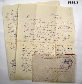
Letter - LETTER HOME FROM CAIRO WW1, 14.3.1916
George Stockett Gerrans No 2336 28 BN AIF. Enlist 20.7.15 RTA 23.8.19 Final rank Lieutenant The letter was writte when he was a Sgt with Postal Corps AIf.1) .2)Two page letter with envelope. The paper is lined and handwriting in blue ink. Written by George Stockett Gerrans No 2336 to his sister Lizzie. He mentions he is leaving soon to “Another place- near where mum was born” .3) Envelope On the envelope has has written “ On active service- no stamps available “ Envelope, one postage rubber stamp is marked Cairo. The other river stamp marked Abbassia, Artillery Barracks Addressed to P. Gerrans Esq. C/o G.R. Chart Esq Pyramid Hill Victoria Australia letters home, cairo, pyramid hill -
 Kiewa Valley Historical Society
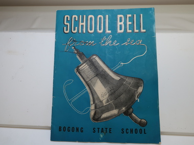
Booklet - Bogong State School x2, School Bell from the Sea
The Story of S.S. "Santhia" sank while in service as a troopship, of her subsequent salvage, and of how her bell came to Bogong School. Bogong State School was built and used from the 1940s when the SECV was constructing the KHES. The school bell was unique having originated from the ship "Santhia'. Teal colored background with the title printed in white at the top and the 'Bogong State School' printed in black at the bottom. 9 pages back to back with information about the School Bell. Published in March-April, 1947Inscribed on the bell - "Presented to G. G. Jobbins, Esq., Chairman, State Electricity Commission by Captain J. P. Williams for Bogong School, on December 6th, 1946. This bell was recovered from the wreck of the S. S. Santhia sunk in the Houghly River, Calcutta, and raised by an Australian salvage party."bogong state school bell, s.e.c. magazine 1947 -
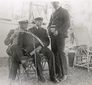 Mission to Seafarers Victoria
Photograph - Photograph, Black and white, Group of Swedes - Boxing Day 1920, 26 December 1920
Supporters of the Mission often made their homes and gardens available as venue for Christmas Boxing day and Cup day events or picnics. On Boxing Day 1920 around 100 men were welcomed by Mr and Mrs Duckett on the grounds of the home Riversdale. They went there on a river excursion.A record of just one group of international sailors a long way from their home an country attending a Mission event. Black and white photograph of a trio of sailors in dress uniform – 2 seated on cane garden chairs one with piano-accordion being played. The standing sailor holds a cameraPencil inscription on verso in pencil handwritten :" Boxing day 1920 / Group of Swedes" ; at right angles a number "893"camera, uniforms, accordeon, accordion, picnic, seamen, swedish, 1920, boxing day, riversdale, edward duckett -
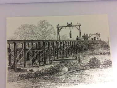 Port of Echuca
A black and white photograph of a drawing, Black and white photograph of a drawing depicting the construction of the iron Murray Bridge, at Echuca, showing Surveyor, bridge workers, hoists, a crane, and much activity, 1981
Original negative and photograph held by The Age, before by Orm Cook, Echuca. Photo is of a drawing of Bridge work taking place in 1877, across Murray River at Echuca. Orm Cook gave The Age the photograph in 1981 as the round arches on the bridge were about to be removed.A bridge crossing of the Murray River was needed by 1877. It linked Echuca and Moama in a more tangible way. The bridge was funded privately and public use of it was discussed for the next several years.A black and white photograph of a drawing, depicting the construction of the iron Murray Bridge at Echuca, showing the Surveyor, the bridge workers, hoists , a crane, and much activity.Written in pen on the back, "Murray Bridge at Echuca under construction. Original to 'Age' came from Orm Cook. Also the numbers 6530 written in pen. Also on the back is a rectangular stamp with these words inside the rectangle. "COPYRIGHT. This photograph may not be reproduced without permission in writing from the Editor of "The Age" 250 Spencer Street, Melbourne, and 39/41 York St, Sydney.murray river, bridge work, bridge construction, bridge workers., the age newspaper., orm cook. -
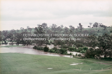 Eltham District Historical Society Inc
Slide, Floodwater, west from Clubhouse of Rosanna Golf Club, Lower Plenty, November 1971, 1971
Many parts of Melbourne flooded including Rosanna Golf Club, Lower Plenty in Novembere 1971. Many surburban roads, including the new south-eastern freeway were cut by flood waters. Here the level of the Plenty River floods onto the golf course. 35 mm colour positive transparency Mount - Agfacolor Service (Blue)floods, lower plenty, rosanna golf club, flooding, plenty river -
 Greensborough Historical Society
Article - Journal - Excerpt, Victorian Government Gazette, Melbourne water supply 1879, 25/04/1879
An historical account from the Victorian Government Gazette 25/04/1879: Contract accepted - Melbourne Water Supply - B. Barnes & Co. Masonry abutments and piers, also construction and erection of wrought iron aqueduct over Plenty River at Morang. 5250 pounds.History of the Maroondah aqueduct1 p., photocopy of article, downloaded from State Library of Victoriamelbourne water, mmbw, maroondah aqueduct, plenty river -
 Greensborough Historical Society
Map, Melbourne and Metropolitan Board of Works. Survey Division, MMBW, Yarra 2500 / 13.26. Yarrambat, Worns Lane, 1978_02
Melbourne and Metropolitan Board of Works. Yarra 2500 [base map] 13.26. Yarrambat, Worns Lane. Municipalities of Diamond Valley 257 and Whittlesea 239. Prominent streets include: Worns Road, North Oatlands Road and Licola Street. Features include Plenty River.MMBW Map in 1:2500 [scale] series. Cream parchment with green tape reinforcing on edges and punched holes on left edge.mmbw, melbourne and metropolitan board of works, shire of diamond valley, whttlesea, yarrambat - maps -
![Photograph - Digital Image, Johannes Adem Bosch [John Adam Bush], 1910c](/media/collectors/4f729f5697f83e03086015b8/items/5441c12a2162f10c081edebc/item-media/5441c15c2162f10c081ee01a/item-fit-380x285.jpg) Greensborough Historical Society
Greensborough Historical SocietyPhotograph - Digital Image, Johannes Adem Bosch [John Adam Bush], 1910c
Photograph of Johannes Bosch cropped from larger photograph. Johannes Bosch and family migrated from Southern Germany to Greensborough district c1889. They farmed along the Plenty River having purchased land from Flintoff. They later changed their surname from Bosch to Bush.Digital copy cropped from black and white photograph.johannes bosch, john adam bush, bosch family, bush family -
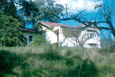
 Greensborough Historical Society
Photograph - Digital Image, The grounds at Blackjack, 1956_
The grounds at Blackjack, the home of the Robinson family to late 1956. The Blackjack property, house and acres of fruit orchards ran down to the Plenty River off Hume Street Greensborough. The photographs were taken as slides by Frank Robinson and digitised by his son James in 2015.Digital copy of colour photograph.blackjack, robinson family -
 Greensborough Historical Society
Photographs, Photographs by Maria Barbaro, 2009_
A collection of over 170 photographs taken by artist Maria Barbaro as studies for her paintings. Taken in the Greensborough area, photos cover a wide range of natural and built landscapes, including the Plenty River; parks and gardens; the Greensborough Hotel; Ashmead; Greensborough railway station.A variety of photographs of the Greensborough area in the early 21st Century.Folder containing approx 150 colour photographs of Greensborough area. Each photograph 10x15cmmaria barbaro, greensborough -
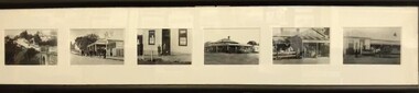 Greensborough Historical Society
Postcards (framed), Greensborough Historical Society, Greensborough Historical Society Postcards. Series One, 2011_08
Set of 6 postcards produced for sale by Greensborough Historical Society. Postcards Left to right: Plenty River Bridge; Quirk's Tea Rooms; Commercial Bank; Farmer's Arms Hotel, all Main Street; Medhurst Fruit Store, and, Greensborough Hotel, Grimshaw Street.6 black and white postcards in black timber frame, under glass.greensborough historical society, main street greensborough, grimshaw street greensborough -
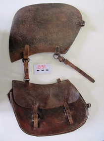 Uniting Church Archives - Synod of Victoria
Saddlebag
This small saddle bag was carried on the off-side (right hand side) of the saddle. Nyah West is a town in Victoria, near the Murray River. It is near the Murray Valley Highway, 371 kilometres north-west of Melbourne and 27 kilometres north-west of Swan Hill.Dark brown leather single small saddlebag. The bag is secured with two buckles. -
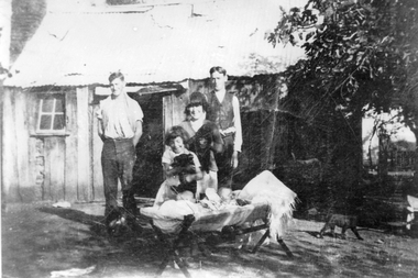 Stawell Historical Society Inc
Photograph, Mr Fred Howard & Mrs Laura Howard nee Unknown at their Dadswell Bridge Home
Home of Fred & Laura Howard married 1902. Standing in front of Slab hut home are four people. Jack Howard, Alan (Ike) Howard. Rene Howard, Sorrie Howard and the twins in the crib Rodger and Andrew Howard. Little Wimmera River Dadswell's Bridge.Black and white photograph of a family group in front of a timber slab home with a corrugated iron roof. The family group consists of two standing and two closer to a crib with two young babies. Two of the females look to be holding animals and a cat can be seen nearby. Jack Howard, Alan (Ike) Howard, Rene Howard, Dorrie Howard and the twins in the crib, Rodger Howard and Andrew Howard. house -
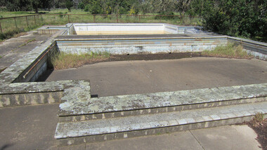 Ballarat Heritage Services
digital photographs, Lisa Gervasoni, Cocoroc pre olympic pool, c2010-2017
In 1892 the Melbourne and Metropolitan Board of Works established the Metropolitan Sewage Farm on the western bank of the Werribee River, to treat the effluent from Melbourne's new sewerage system.This area was isolated and too far from Melbourne, so the Cocoroc village was built to house the workers.Colour photograph of the Cocoroc Swimming Pool. This pool was built by the town's residents.swimming pool, sport, swimming, pre olympic, concrete, cocoroc, cocoroc swimming pool