Showing 11460 items matching " maps"
-
 Bendigo Historical Society Inc.
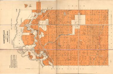
Map - JACK FLYNN COLLECTION: KANYAPELLA, 22/05/1939
Map: Parish of Kanyapella, Counties of Rodney and Moira. Parish plan.By Authority, T. Rider Acting Govt, Printer Melbourne. Drawn and Reproduced at the Dept. of Lands and Survey, Melbourne, Victoria.map, moira, parish plan, kanyapella, counties of rodney and moira -
 Bendigo Historical Society Inc.
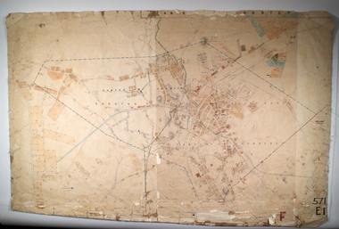
Map - EAGLEHAWK, Circa 1870's
Map: Eaglehawk, Compilation of 2 parish plans covering Eaglehawkmap, bendigo, parish plan, eaglehawk -
 Bendigo Historical Society Inc.
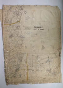
Map - SANDHURST SHEET 1, 27/05/1925
Map: Sandhurst ,County of Bendigo, sheet 1. Parish planmap, bendigo, parish plan, sandhurst -
 Bendigo Historical Society Inc.
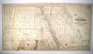
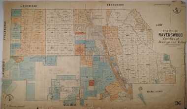
Map - PARISH OF RAVENSWOOD, Circa 1908
Map: Parish of Ravenswood, Counties of Bendigo and Talbot. Parish planmap, bendigo, parish plan, ravenswood, county of talbot -
 Ballarat Tramway Museum
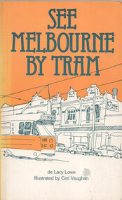
Book, de Lacy Lowe et al, "See Melbourne by Tram", 1982
Book titled "See Melbourne by Tram" written by de Lacy Lowe, illustrated by Ceri Vaughan, published 1982. Gives a description of 22 Melbourne tram routes with a stop description (not all stops covered) and sketches associated with the location. Has an index in the rear pages.Yields information about Melbourne Trams, their routes and what to see in 1982.Book - 160 pages + card cover with maps on inside covers.Has a handwritten gift notation of 1982 on page 2.trams, tramways, melbourne, tram routes, tram stops, tourist guides, illustrations -
 Bendigo Historical Society Inc.
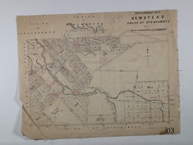
Map - NEWSTEAD ALLOTMENTS, 10/06/1886
Map: Town ans Suburban Lots, Newstead, Parish of Strangwaysmap, allotments, newstead , allotments, parish of strangways -
 Stawell Historical Society Inc
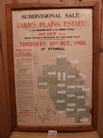
Memorabilia - Realia, 1905
Carr’s Plains Estate Subdivision Sale Poster with Subdivision Mapstawell -
 Stawell Historical Society Inc
Map, Department of Lands and Survey Melbourne, Swinton Estate. Parish of Riachella. County of Borong, 3-08-1921
Shows part of Warranook TrainwayA1 Printed Map With Cloth Backing. Annotations in Red Ink W.J. Butson 3-8-21farming -
 Bendigo Historical Society Inc.
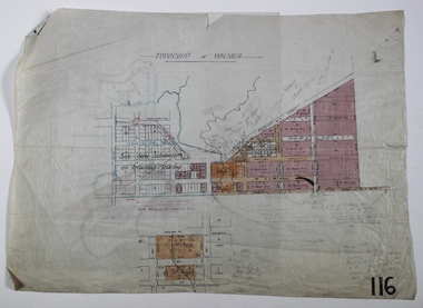
Map - WALMER, Circa 1900
Map: Township of Walmer, 2 hand Draughted Parish plansmap, township, walmer -
 Bendigo Historical Society Inc.
Map - PARISH OF RAVENSWOOD, 3/04/1875
Map: Parish of Ravenswood, Counties of Bendigo and Talbot. Parish planmap, bendigo, parish plan, ravenswood, county of talbot, county of bendigo -
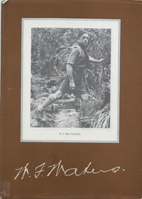 Falls Creek Historical Society
Book - W.F. Waters - A Biography - A Man of the Mountains, Harry Stephenson, 1982
A biography of William Francis Waters which outlines his earlier life and sporting success. It details his exploits in hiking and skiing, including being member of the first party to ski across the Bogong High Plains. Becoming a Rover Scout in 1928, his contribution to the scouting movement led to the award of the Silver Wolf, the highest scouting honour in 1961.A book of 96 pages including maps, illustrations, facsimiles and indexnon-fictionA biography of William Francis Waters which outlines his earlier life and sporting success. It details his exploits in hiking and skiing, including being member of the first party to ski across the Bogong High Plains. Becoming a Rover Scout in 1928, his contribution to the scouting movement led to the award of the Silver Wolf, the highest scouting honour in 1961.william francis waters, hiking victoria, scouting victoria -
 Bendigo Historical Society Inc.
Map - CAMPBELL COLLECTION: BENDIGO AND DISTRICT MAPS
Map. Parish of Sandhurst, Shire of Strathfieldsaye, Mandurang Parish, Junortoun.map, bendigo, city streets -
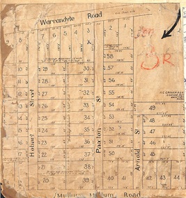 Ringwood and District Historical Society
Map, Residential Subdivision Allotment Layout on Mullum Mullum Road, Hobart Street, Paxton Street, Arnold Street and Warrandyte Road, Ringwood, Vic. circa 1920
One of 3 unrelated land subdivision maps on cardboard backing.H.C. Crouch, Licensed Surveyor, 443 Lt Collins Street, Melbourne. -
 Bendigo Historical Society Inc.
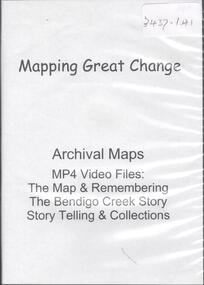
Map - MAPPING GREAT CHANGE
DVD. Mapping Great Change. Archival Maps. Two copies. -
 Falls Creek Historical Society
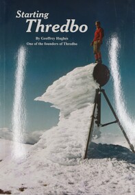
Book - Starting Thredbo, Geoffrey Hughes, 2008
Geoffrey Hughes, one of the original founders of Thredbo first laid eyes on the vast, rich forest of Thredbo Valley in 1955 and envisioned a ski resort for all. This book documents the transformation and development of the area to become one of Australia's most popular holiday destinations, Thredbo Ski Resort.A publication of 44 pages including colour photos, illustrations and maps.non-fictionGeoffrey Hughes, one of the original founders of Thredbo first laid eyes on the vast, rich forest of Thredbo Valley in 1955 and envisioned a ski resort for all. This book documents the transformation and development of the area to become one of Australia's most popular holiday destinations, Thredbo Ski Resort.thredbo ski resort, alpine resorts australia -
 Ringwood and District Historical Society
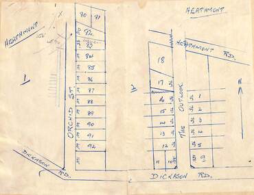
Map - Subdivision Plans, Residential allotments in Orchid Street and The Outlook, between Heathmont Road and Dickason Road, Heathmont, Victoria - (Undated - circa 1930s)
Two adjoing hand-drawn maps on light cardboard backing. -
 Warrnambool and District Historical Society Inc.
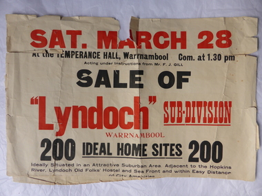
Poster, Lyndoch Sub-Division
This is a poster advertising the sale of the Lyndoch sub-division in Warrnambool with the sale of 200 housing sites. The sale took place about 1958 with the land sold by Frederick Gill, a Warrnambool jeweller. The land was previously owned by George Rolfe who had acquired the land near the mouth of the Hopkins River in the 1880s and named the property ‘Lyndoch’. He bought the surrounding land at a later time. This sub-division came to be known as the Gill Estate. It was a valuable site as many of the allotments fronted the sea and others were adjacent to the Hopkins River. This poster, although tattered, is of interest as it has many details of the Gill Estate sub-division and will be useful to researchers. This is a cream-coloured paper poster with black and red printing. The poster has a small map in a circle shape showing the location of the streets and a larger map section showing the streets and the allotments to be sold. The poster is in two pieces and the edges are torn and, in some sections, missing. The streets map has some pencil annotations. history of warrnambool, lyndoch, warrnambool, george rolfe, frederick gill -
Warrnambool and District Historical Society Inc.
Document - Documents (3) of Farnham Cheese and Butter factory, 1890s (originals)
These three sheets are copies of the originals and relate to the establishment of the Farnham Cheese and Butter Factory in Dennington (Warrnambool). The name 'Farnham' is the name of the Special Survey in the area first purchased by William Rutledge and also the name of the Rutledge property at Dennington. In 1889 WIlliam Rutledge (Junior) and Thomas Palmer established the Farnham Cheese and Butter Factory on the banks of the Merri River at Dennington. In 1890 they sold the factory to a farmers' co-operative. Farnham had a high reputationfor butter=making when the factory was in existence. The factory was bought out by Nestles about 1909 with that company establishing its factory on the same area.in 1911. These documents are of interest as the Farnham Cheese and Butter Factory was one of the earliest of its type in the Western District and won a Gold Medal in 1909 for butter-making at the Islington Dairy Show in competition with other butter-making countries in the world..1 sheet of paper with black and white map showing location of factory in Dennington (copy) .2 An A3 size piece of paper with a sketch map and typed material showing a Certificate of Title (copy) .3 An 3 size piece of paper with a sketch map and typed material showing a Certificate of Title (copy)farnham cheese and butter factory, nestles factory warrnambool -
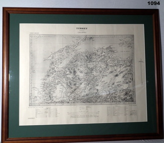 Bendigo Military Museum
Map - MAP GALLIPOLI, FRAMED
Brown, wooden frame with glass front, white cardboard backing, map mounted with green border. Map of Gallipoli area in black & light grey with white border. A detailed map of Turkey area around Dardanelles with references & scale charts at bottom. Reprinted for the Department of Defence, Commonwealth of Australia, May 1915.Front Top Centre: Turkey, Gallipoli. Rear: Bethany Gallery stamp.documents - maps, military history, gallipoli -
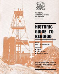 Bendigo Historical Society Inc.
Book - HISTORIC GUIDE TO BENDIGO
Five copies of ' The Royal Historical Society of Victoria Bendigo Branch Historic Guide to Bendigo with map of goldfields showing streets, lines of reef, principal shafts. Recommended for tourists, students, prospectors and historians.' Cambridge Press, Bendigo. Third Edition. Maps, photos, illustratons. Only four copies have maps.bendigo, history, gold mining, book, books, bendigo, bendigo history, history, victorian history, victoria, australian history, gold fields, gold, gold discoveries, the royal historical society of victoria -
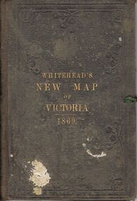 Bendigo Historical Society Inc.
Book - WHITEHEAD'S NEW MAP OF VICTORIA 1869, 1869
A brown/grey embossed book, with gold lettering titled 'Whitehead's New Map of Victoria 1869' containing a cloth bound map of Victoria, with coloured regions, with an alphabetical key of towns. Markings - ?(possibly J C) Bailey written on reverse of map in pen. In pencil inside book is marked 'W C'victoria, history, map -
University of Melbourne, Burnley Campus Archives
Map, Photo Mapping Services Pty. Ltd, Burnley College Burnley Gardens, 1995
HistoricalMap compiled by Photo Mapping Services Pty. Ltd., using aerial photography, dated 9th July, 1995. (1) Coloured proof. Scale 1:500. Aerial views, with and without trees marked, of Burnley Gardens: (2) Map with trees (3) Map without trees, sections numbered but no legend.burnley college, gardens, trees -
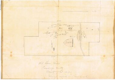
 Bacchus Marsh & District Historical Society
Map, Plan of Land at Bacchus Marsh, the Property of James Young, 1868
James Young was a prominent businessman, land owner and public figure in the early colonial period of Bacchus Marsh. In February 1868 he offered for sale through the agent W. Anderson 38 blocks of land which ran from the Lerderderg RIver westwards beyond Gisborne Road in the vicinity of the present day Masons Land. The land for sale was described as, 'unsurpassed Agricultural Land, in the immediate vicinity of Bacchus Marsh, varying in size from 2 to 12 acres each'. The sale notice in the Bacchus Marsh Express of 1st February 1868 page 2, also noted that, ' Plans can be seen at Mr. Young's Border Mills Store, and at the Border Inn'. One of the largest and most important land sales in the early colonial period of Bacchus Marsh.A single page paper map showing 38 blocks of land for sale in 1868 in the vicinity of Masons Lane Bacchus Marsh. Scale 11 chains to 1 inch. The map is pasted into a bound volume containing 76 maps or plans in total. High resolution digital image stored on BMDHS computer network. land sales bacchus marsh, bacchus marsh victoria maps, james young 1816-1871, masons lane bacchus marsh land sales -
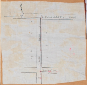 Bacchus Marsh & District Historical Society
Map, Lord Street, Bacchus Marsh. Undated
A small single page map showing the line of Lord Street Bacchus Marsh between Ballarat Road (Main Street) and Simpson Street. Part of a set of maps which are pasted into a bound volume containing 76 maps or plans in total. High resolution digital image stored on BMDHS computer network. bacchus marsh victoria maps, lord street bacchus marsh maps -
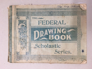 Warrnambool and District Historical Society Inc.
Booklet, The Federal Drawing Book Scholastic Series, C 1930
This school book which was owned by George Mathieson contains maps and information on different countries around the world. It is handwritten and is probably of secondary school level. The maps appear to have been traced and hand-drawn and coloured. There is a loose newspaper map of the Dardenelles loose in the book. This book as an example of school work and geography in the early 20th century, has social and historical significance.Pale green light card cover with dark green pattern and text. Back cover is plain. It contains alternate pages of tracing paper in between normal pages. Bound with cotton? threadGeorge mathieson, written in ink on front cover.federal drawing book, george mathieson, school drawing book 1920's, warrnambool -
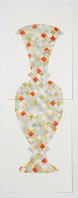 Federation University Art Collection
Artwork, other - Handcut & Collaged maps on paper, 'Survey Vessel I' by Carole Wilson, 2008
... maps ...Carole WILSON (1960- ) Born Canberra, Australia Carole Wilson undertook undergraduate studies at the Canberra School of Arts and Phillip Institute of Technology. She completed a Graduate Diploma in Education at the University of Ballarat in 1987, and a Doctor of Philosophy in 2000. She has chosen central motifs in her work, which she incorporates throughout a series. The urn has been a unifying motif in Wilson's map work and testifies to the way in which function drives form across cultures. Carole's work is held in many public collections including the National Gallery of Australia, the Powerhouse Museum, State Library of Victoria and a number of regional Victorian galleries. Her posters are in museum collections in Finland, Moscow and Poland. In 2001 Dr Wilson was awarded a Doctor of Philosophy (Visual Art) from the University of Ballarat (Now Federation University). She graduated with a Graduate Diploma in Education from University of Ballarat in 1987, and a Diploma of Art from the Phillip Institute of Technology (RMIT) in 1984. Carole Wilson lectures at Federation University Australia: 2010- Senior Lecturer in Visual Arts, Honours and Research Degrees Co-ordinator 2009-2011 Lecturer in Studio Practice and Postgraduate Co-ordinator 1999-2008 Lecturer in Visual Arts (Sessional) This item is part of the Federation University Art Collection. The Art Collection features over 2000 works and was listed as a 'Ballarat Treasure' in 2007. Donated through the Australian Government's Cultural Gifts Program by Anne M. Drum, 2011art, artwork, carole wilson, maps, urn, alumni, available, staffmember -
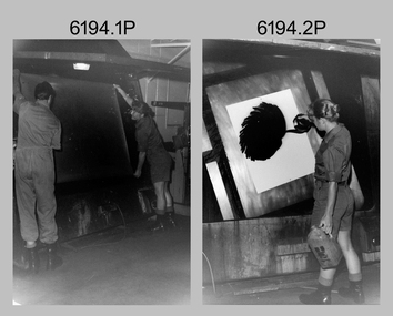 Bendigo Military Museum
Photograph - Lithographic Technicians and Equipment at the Army Survey Regiment, Fortuna Villa Bendigo, c1990s
These 10 photographs were most likely taken in the 1990s in Lithographic Squadron at the Army Survey Regiment, Fortuna, Bendigo. In photos .1P to .2P the technicians are applying a UV-sensitive pigmented dye emulating one of the print colours to a white opaque polyester sheet mounted on a rotating table in a whirler. The coated sheet was dried before placement in a vacuum light frame beneath a stud registered map negative. They were then exposed to a carbon arc lamp. For more photos and details on the process, see item 6059.5P. In photos .3P to .5P the technician is preparing a orthophotomap film positive. Photo .6P is the rear view of the tri-linear film punch. In photos .7P and .8P the technician is operating a heavy-duty guillotine to trim bulk printed map stock. Cartographers normally provided trim marks to specified map dimensions as guidance to the printer. The trimming stage, like all the other printing processes required high levels of accuracy. These guillotines were extremely powerful to cut through bulk quantities of printed maps. For more photos and details on this process, see item 6069.6P. In photo .9P the technician is operating a daylight film contacting frame. In photo .10P LT Ian Stoddart is taking a well-earned break.This is a set of 10 photographs of lithographic technicians undertaking tasks at the Army Survey Regiment, Bendigo c1990s. Photos .1P to .7P and .9P to .11P are on 35mm negative film and scanned at 96 dpi. Photo .8P is printed on photographic paper and scanned at 300 dpi. They are part of the Army Survey Regiment’s Collection. .1) and .2) - Photo, black & white, c1990s, unidentified printer technician and SPR Janet Murray using the map proof whirler. .3) to .5) - Colour, c1990s, Mick ‘Buddha’ Ellis preparing an orthophotomap film positive. .6) - Photo, Colour, c1990s, rear view of tri-linear film punch. .7) & .8) - Photo, Colour, c1990s, unidentified technician operating a heavy-duty guillotine. .9) - Photo, Colour, c1990s, printer technician SPR Shona Hastie operating a daylight film contacting frame. .10) - Photo, Colour, c1990s, LT Ian Stoddart taking a well-earned break. .1P to .10P– no annotationroyal australian survey corps, rasvy, army survey regiment, army svy regt, fortuna, asr, litho -
 Bendigo Historical Society Inc.
Map - OLD TOM MINE, WHIPSTICK
2 copies ( A4 and A3) of Old Tom lease. Map shows Old Tom Reef, old working open cutting, shaft 150 ft., Easter Reef, dam sand heap, water race, 3 other shafts, 120ft., 90ft., and 500 ft. marked on map. Stamped on map '64.3.34' Written on bottom of map in handwriting ' Old Tom Lease, Parish of Huntly, County of Bendigo, Mining district of Sandhurst'bendigo, mining, old tom lease map -
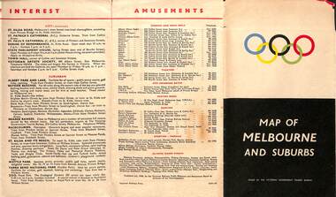 Melbourne Tram Museum
Map, Victorian Government Tourist Bureau, "Map of Melbourne and Suburbs", Jul. 1956
Map - .folded 12 sections full colour titled "Map of Melbourne and Suburbs". Issued at the time of the Melbourne Olympics by the Victorian Government Tourist Bureau. Has an index of Melbourne's suburbs, transport links, Places of Interest, Amusements, Facts of interest about Victoria. Major map shows the rail and tram lines, the detailed map of the CBD shows the buildings or locations referenced in the Tourist Guide to the City. Printed by the Victorian Railways - 2133-56trams, tramways, map, olympics, public transport, melbourne -
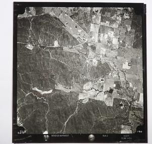 Bendigo Historical Society Inc.
Map - CAMPBELL COLLECTION: BENDIGO AND DISTRICT MAPS
Map. Two aerial photographs of Kangaroo Flat and Lockwood (part). Crusoe Reservoir bottom right corner on Crusoe Road, shows Merindah Road running between Lockwood and Crusoe Roads. Map Name : Bendigo Mapsheet Run 2. 14-2-71, 13,200 A.S.L.. Map shown with NORTH at bottom of page, VIC 2479 at corner. Map 2 continues to the west. A joined copy of both photographs is also included.map, bendigo, agricultural lands